A multipart geometry can be densified by adding interpolated points at regular intervals. Generalizing a multipart geometry simplifies it while preserving its general shape. Densifying a multipart geometry adds more vertices at regular intervals.
Use case
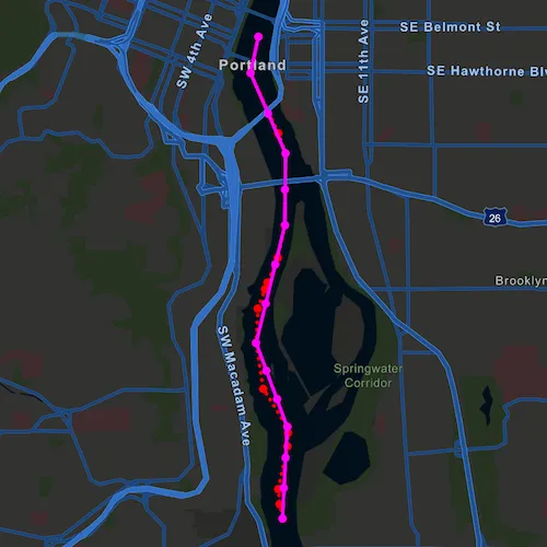
The sample shows a polyline representing a ship’s location at irregular intervals. The density of vertices along the ship’s route is appropriate to represent the path of the ship at the sample map view’s initial scale. However, that level of detail may be too great if you wanted to show a polyline of the ship’s movement down the whole of the Willamette river. Then, you might consider generalizing the polyline to still faithfully represent the ship’s passage on the river without having an overly complicated geometry.
Densifying a multipart geometry can be used to more accurately represent curved lines or to add more regularity to the vertices making up a multipart geometry.
How to use the sample
Use the sliders to control the parameters of the densify and generalize methods. You can deselect the checkboxes for either method to remove its effect from the result polyline.
How it works
- Use the static method
GeometryEngine::densify(polyline, maxSegmentLength)to densify the polyline object. The resulting polyline object will have more points along the line, so that there are no points greater thanmaxSegmentLengthfrom the next point. - Use the static method
GeometryEngine::generalize(polyline, maxDeviation, true)to generalize the polyline object. The resulting polyline object will have points shifted from the original line to simplify the shape. None of these points can deviate farther from the original line thanmaxDeviation. The last parameter,removeDegenerateParts, will clean up extraneous parts of a multipart geometry. This will have no effect in this sample as the polyline does not contain extraneous parts. - Note that
maxSegmentLengthandmaxDeviationare in the units of the geometry’s coordinate system. In this example, a cartesian coordinate system is used and at a small enough scale that geodesic distances are not required.
Relevant API
- GeometryEngine
- Multipoint
- Point
- PointCollection
- Polyline
- SimpleLineSymbol
- SpatialReference
Tags
densify, Edit and Manage Data, generalize, simplify
Sample code
// [WriteFile Name=DensifyAndGeneralize, Category=Geometry]// [Legal]// Copyright 2018 Esri.//// Licensed under the Apache License, Version 2.0 (the "License");// you may not use this file except in compliance with the License.// You may obtain a copy of the License at// http://www.apache.org/licenses/LICENSE-2.0//// Unless required by applicable law or agreed to in writing, software// distributed under the License is distributed on an "AS IS" BASIS,// WITHOUT WARRANTIES OR CONDITIONS OF ANY KIND, either express or implied.// See the License for the specific language governing permissions and// limitations under the License.// [Legal]
#ifdef PCH_BUILD#include "pch.hpp"#endif // PCH_BUILD
// sample headers#include "DensifyAndGeneralize.h"
// ArcGIS Maps SDK headers#include "Envelope.h"#include "GeometryEngine.h"#include "Graphic.h"#include "GraphicListModel.h"#include "GraphicsOverlay.h"#include "GraphicsOverlayListModel.h"#include "ImmutablePart.h"#include "ImmutablePartCollection.h"#include "ImmutablePointCollection.h"#include "Map.h"#include "MapQuickView.h"#include "MapTypes.h"#include "MultipointBuilder.h"#include "Point.h"#include "PointCollection.h"#include "Polyline.h"#include "PolylineBuilder.h"#include "SimpleLineSymbol.h"#include "SimpleMarkerSymbol.h"#include "SpatialReference.h"#include "SymbolTypes.h"
// Qt headers#include <QFuture>
using namespace Esri::ArcGISRuntime;
DensifyAndGeneralize::DensifyAndGeneralize(QQuickItem* parent /* = nullptr */):  QQuickItem(parent){}
void DensifyAndGeneralize::init(){  // Register the map view for QML  qmlRegisterType<MapQuickView>("Esri.Samples", 1, 0, "MapView");  qmlRegisterType<DensifyAndGeneralize>("Esri.Samples", 1, 0, "DensifyAndGeneralizeSample");}
void DensifyAndGeneralize::componentComplete(){  QQuickItem::componentComplete();
  // find QML MapView component  m_mapView = findChild<MapQuickView*>("mapView");
  // Create a map using the streets night vector basemap  m_map = new Map(BasemapStyle::ArcGISStreetsNight, this);
  // Add a GraphicsOverlay  m_graphicsOverlay = new GraphicsOverlay(this);  m_mapView->graphicsOverlays()->append(m_graphicsOverlay);
  // Get Points along the river  PointCollection* pointCollection = createPointCollection();
  // original multipart red graphic  MultipointBuilder multipointBuilder(pointCollection->spatialReference());  multipointBuilder.setPoints(pointCollection);  SimpleMarkerSymbol* originalSms = new SimpleMarkerSymbol(SimpleMarkerSymbolStyle::Circle, QColor("red"), 7.0f /*size*/, this);  m_originalMultipointGraphic = new Graphic(multipointBuilder.toGeometry(), originalSms, this);  m_originalMultipointGraphic->setZIndex(0);  m_graphicsOverlay->graphics()->append(m_originalMultipointGraphic);
  // original red dotted line graphic  PolylineBuilder polylineBuilder(pointCollection->spatialReference());  const int pointCollectionSize = pointCollection->size();  for (int i = 0; i < pointCollectionSize; i++)  {    polylineBuilder.addPoint(pointCollection->point(i));  }  SimpleLineSymbol* originalSls = new SimpleLineSymbol(SimpleLineSymbolStyle::Dot, QColor("red"), 3.0f /*size*/, this);  m_originalLineGraphic = new Graphic(polylineBuilder.toGeometry(), originalSls, this);  m_originalLineGraphic->setZIndex(1);  m_graphicsOverlay->graphics()->append(m_originalLineGraphic);
  // resulting (densified and generalized) multipart magenta graphic  SimpleMarkerSymbol* resultSms = new SimpleMarkerSymbol(SimpleMarkerSymbolStyle::Circle, QColor("magenta"), 7.0f /*size*/, this);  m_resultMultipointGraphic = new Graphic(this);  m_resultMultipointGraphic->setSymbol(resultSms);  m_resultMultipointGraphic->setZIndex(2);  m_graphicsOverlay->graphics()->append(m_resultMultipointGraphic);
  // resulting (densified and generalized) multipart magenta graphic  SimpleLineSymbol* resultSls = new SimpleLineSymbol(SimpleLineSymbolStyle::Solid, QColor("magenta"), 3.0f /*size*/, this);  m_resultLineGraphic = new Graphic(this);  m_resultLineGraphic->setSymbol(resultSls);  m_resultLineGraphic->setZIndex(3);  m_graphicsOverlay->graphics()->append(m_resultLineGraphic);
  // Set map to map view  m_mapView->setMap(m_map);
  // set viewpoint  m_mapView->setViewpointGeometryAsync(m_originalMultipointGraphic->geometry().extent(), 100);}
void DensifyAndGeneralize::updateGeometry(bool densify, double maxSegmentLength, bool generalize, double maxDeviation){  if (!m_originalLineGraphic)    return;
  // Get the initial Geometry  Polyline polyline = geometry_cast<Polyline>(m_originalLineGraphic->geometry());  if (polyline.isEmpty())    return;
  // Generalize the polyline  if (generalize)    polyline = geometry_cast<Polyline>(GeometryEngine::generalize(polyline, maxDeviation, true));
  // Densify the polyline  if (densify)    polyline = geometry_cast<Polyline>(GeometryEngine::densify(polyline, maxSegmentLength));
  // Update the line graphic  m_resultLineGraphic->setGeometry(polyline);
  // Update the multipoint graphic  if (polyline.parts().size() < 1)    return;
  MultipointBuilder multipointBuilder(polyline.spatialReference());  PointCollection* pointCollection = new PointCollection(polyline.spatialReference(), this);
  ImmutablePointCollection polylinePoints = polyline.parts().part(0).points();  const int polylinePointsSize = polylinePoints.size();  for (int i = 0; i < polylinePointsSize; i++)  {    pointCollection->addPoint(polylinePoints.point(i));  }  multipointBuilder.setPoints(pointCollection);  m_resultMultipointGraphic->setGeometry(multipointBuilder.toGeometry());}
PointCollection* DensifyAndGeneralize::createPointCollection(){  SpatialReference sr(32126);  PointCollection* pointCollection = new PointCollection(sr, this);  pointCollection->addPoint(2330611.130549, 202360.002957, 0.000000);  pointCollection->addPoint(2330583.834672, 202525.984012, 0.000000);  pointCollection->addPoint(2330574.164902, 202691.488009, 0.000000);  pointCollection->addPoint(2330689.292623, 203170.045888, 0.000000);  pointCollection->addPoint(2330696.773344, 203317.495798, 0.000000);  pointCollection->addPoint(2330691.419723, 203380.917080, 0.000000);  pointCollection->addPoint(2330435.065296, 203816.662457, 0.000000);  pointCollection->addPoint(2330369.500800, 204329.861789, 0.000000);  pointCollection->addPoint(2330400.929891, 204712.129673, 0.000000);  pointCollection->addPoint(2330484.300447, 204927.797132, 0.000000);  pointCollection->addPoint(2330514.469919, 205000.792463, 0.000000);  pointCollection->addPoint(2330638.099138, 205271.601116, 0.000000);  pointCollection->addPoint(2330725.315888, 205631.231308, 0.000000);  pointCollection->addPoint(2330755.640702, 206433.354860, 0.000000);  pointCollection->addPoint(2330680.644719, 206660.240923, 0.000000);  pointCollection->addPoint(2330386.957926, 207340.947204, 0.000000);  pointCollection->addPoint(2330485.861737, 207742.298501, 0.000000);  return pointCollection;}
void DensifyAndGeneralize::showResults(bool show){  m_resultMultipointGraphic->setVisible(show);  m_resultLineGraphic->setVisible(show);}
// [WriteFile Name=DensifyAndGeneralize, Category=Geometry]// [Legal]// Copyright 2018 Esri.//// Licensed under the Apache License, Version 2.0 (the "License");// you may not use this file except in compliance with the License.// You may obtain a copy of the License at// http://www.apache.org/licenses/LICENSE-2.0//// Unless required by applicable law or agreed to in writing, software// distributed under the License is distributed on an "AS IS" BASIS,// WITHOUT WARRANTIES OR CONDITIONS OF ANY KIND, either express or implied.// See the License for the specific language governing permissions and// limitations under the License.// [Legal]
#ifndef DENSIFYANDGENERALIZE_H#define DENSIFYANDGENERALIZE_H
// Qt headers#include <QQuickItem>
// STL headers#include <PointCollection.h>
namespace Esri::ArcGISRuntime{class Map;class MapQuickView;class GraphicsOverlay;class Graphic;class PointCollection;}
class DensifyAndGeneralize : public QQuickItem{ Q_OBJECT
public: explicit DensifyAndGeneralize(QQuickItem* parent = nullptr); ~DensifyAndGeneralize() override = default;
void componentComplete() override; static void init(); Q_INVOKABLE void updateGeometry(bool densify, double maxSegmentLength, bool generalize, double maxDeviation); Q_INVOKABLE void showResults(bool show);
private: Esri::ArcGISRuntime::Map* m_map = nullptr; Esri::ArcGISRuntime::MapQuickView* m_mapView = nullptr; Esri::ArcGISRuntime::GraphicsOverlay* m_graphicsOverlay = nullptr; Esri::ArcGISRuntime::Graphic* m_originalMultipointGraphic = nullptr; Esri::ArcGISRuntime::Graphic* m_originalLineGraphic = nullptr; Esri::ArcGISRuntime::Graphic* m_resultMultipointGraphic = nullptr; Esri::ArcGISRuntime::Graphic* m_resultLineGraphic = nullptr;
Esri::ArcGISRuntime::PointCollection* createPointCollection();};
#endif // DENSIFYANDGENERALIZE_H// [WriteFile Name=DensifyAndGeneralize, Category=Geometry]// [Legal]// Copyright 2018 Esri.//// Licensed under the Apache License, Version 2.0 (the "License");// you may not use this file except in compliance with the License.// You may obtain a copy of the License at// http://www.apache.org/licenses/LICENSE-2.0//// Unless required by applicable law or agreed to in writing, software// distributed under the License is distributed on an "AS IS" BASIS,// WITHOUT WARRANTIES OR CONDITIONS OF ANY KIND, either express or implied.// See the License for the specific language governing permissions and// limitations under the License.// [Legal]
import QtQuickimport QtQuick.Windowimport QtQuick.Controlsimport Esri.Samples
DensifyAndGeneralizeSample { id: rootRectangle clip: true width: 800 height: 600
// add a mapView component MapView { anchors.fill: parent objectName: "mapView"
Component.onCompleted: { // Set the focus on MapView to initially enable keyboard navigation forceActiveFocus(); } }
Rectangle { anchors { fill: controlColumn margins: -5 } color: "#f9f9f9" radius: 5 }
Column { id: controlColumn anchors { left: parent.left top: parent.top margins: 10 } spacing: 5
CheckBox { id: densifyCheckbox text: "Densify" checked: true }
Text { text: "Max segment length" enabled: densifyCheckbox.checked }
Slider { id: maxSegmentLengthSlider from: 100 to: 500 width: 175 value: 100 onValueChanged: updateGeometry(densifyCheckbox.checked, maxSegmentLengthSlider.value, generalizeCheckbox.checked, maxDeviationSlider.value); }
CheckBox { id: generalizeCheckbox text: "Generalize" checked: true }
Text { text: "Max deviation" enabled: generalizeCheckbox.checked }
Slider { id: maxDeviationSlider from: 1 to: 250 width: 175 onValueChanged: updateGeometry(densifyCheckbox.checked, maxSegmentLengthSlider.value, generalizeCheckbox.checked, maxDeviationSlider.value); }
CheckBox { id: showResultCheckbox text: "Show Result" checked: true onCheckedChanged: showResults(checked); } }}