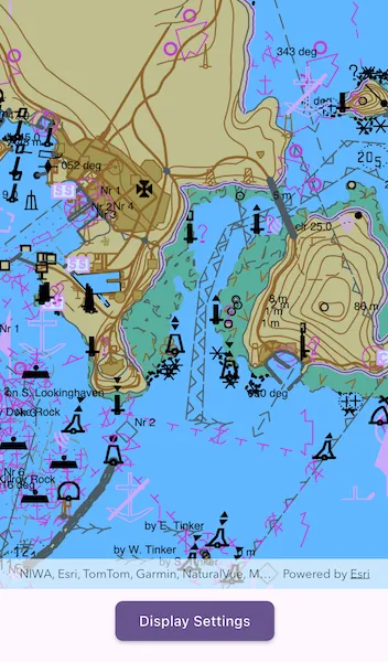
Display and configure electronic navigational charts per ENC specification.
Use case
The S-52 standard defines how Electronic Navigational Chart (ENC) content should be displayed to ensure that data is presented consistently across every charting system. S-52 defines several display options, including variations on symbology to ensure that charts are readable both at night and in direct sunlight.
How to use the sample
When opened, the sample displays an electronic navigational chart. Tap on the map to select ENC features and view the feature’s acronyms and descriptions shown in a callout. Tap “Display Settings” and use the options to adjust some of the ENC mariner display settings, such as the colors and symbology.
How it works
- To display ENC content:
- On
EncLayer.getEnvironmentSettings(), setresourceUrito the local hydrography data directory andsencDataUrito a temporary directory. - Create an
EncExchangeSetusing URIs to the local ENC exchange set files and load it. - Make an
EncCellfor each of theEncExchangeSet.datasetsand then make anEncLayerfrom each cell. - Add the layers to the map using
ArcGISMap.operationalLayers.addAll()and create anArcGISMapViewto display the map.
- On
- To select ENC features:
- Use
ArcGISMapView.onTapto get the screen point from the tapped location. - Use
ArcGISMapViewController.identifyLayers()to identify nearby features to the tapped location. - From the resulting
IdentifyLayerResult, get theEncLayerfromlayerContentand theEncFeaturefromgeoElements. - Use
EncLayer.selectFeature()to select the ENC feature.
- Use
- To set ENC display settings:
- Get the
EncDisplaySettingsinstance fromEncLayer.getEnvironmentSettings().displaySettings. - Use
marinerSettings,textGroupVisibilitySettings, andviewingGroupSettingsto access the settings instances and set their properties. - Reset the display settings using
resetToDefaults()on the settings instances.
- Get the
Relevant API
- EncCell
- EncDataset
- EncDisplaySettings
- EncEnvironmentSettings
- EncExchangeSet
- EncLayer
- EncMarinerSettings
- EncTextGroupVisibilitySettings
- EncViewingGroupSettings
- IdentifyLayerResult
Offline data
This sample automatically downloads the ENC Exchange Set without updates item from ArcGIS Online.
The Hydrography Data is a separate resource from the ENC exchange set. If it is not already provided with your sample data, download it from the Esri Developer downloads. The S57DataDictionary.xml file is included in that download.
Additional information
Read more about displaying and deploying electronic navigational charts on Esri Developer.
Tags
ENC, hydrography, identify, IHO, layers, maritime, nautical chart, S-52, S-57, select, settings, symbology
Sample code
// Copyright 2026 Esri//// Licensed under the Apache License, Version 2.0 (the "License");// you may not use this file except in compliance with the License.// You may obtain a copy of the License at////   https://www.apache.org/licenses/LICENSE-2.0//// Unless required by applicable law or agreed to in writing, software// distributed under the License is distributed on an "AS IS" BASIS,// WITHOUT WARRANTIES OR CONDITIONS OF ANY KIND, either express or implied.// See the License for the specific language governing permissions and// limitations under the License.//
import 'dart:io';
import 'package:arcgis_maps/arcgis_maps.dart';import 'package:arcgis_maps_sdk_flutter_samples/common/common.dart';import 'package:flutter/material.dart';import 'package:go_router/go_router.dart';
class ConfigureElectronicNavigationalCharts extends StatefulWidget {  const ConfigureElectronicNavigationalCharts({super.key});
  @override  State<ConfigureElectronicNavigationalCharts> createState() =>      _ConfigureElectronicNavigationalChartsState();}
class _ConfigureElectronicNavigationalChartsState    extends State<ConfigureElectronicNavigationalCharts>    with SampleStateSupport {  // Create a controller for the map view.  final _mapViewController = ArcGISMapView.createController();  // The ENC layers displayed in the map.  final _encLayers = <EncLayer>[];  // A flag for when the map view is ready and controls can be used.  var _ready = false;  // A temporary directory for generated SENC data.  Directory? _sencDataDirectory;  // The current ENC mariner display setting values.  var _colorScheme = EncColorScheme.day;  var _areaSymbolizationType = EncAreaSymbolizationType.symbolized;  var _pointSymbolizationType = EncPointSymbolizationType.paperChart;
  @override  void dispose() {    final environmentSettings = EncLayer.getEnvironmentSettings();
    // Reset global ENC environment paths and display settings when leaving the sample.    environmentSettings.resourceUri = null;    environmentSettings.sencDataUri = null;    environmentSettings.displaySettings.marinerSettings.resetToDefaults();    environmentSettings.displaySettings.textGroupVisibilitySettings        .resetToDefaults();    environmentSettings.displaySettings.viewingGroupSettings.resetToDefaults();
    // Remove the temporary SENC files created while loading ENC content.    _sencDataDirectory?.deleteSync(recursive: true);    super.dispose();  }
  @override  Widget build(BuildContext context) {    return Scaffold(      body: SafeArea(        top: false,        left: false,        right: false,        child: Stack(          children: [            Column(              children: [                Expanded(                  // Add a map view to the widget tree and set a controller.                  child: ArcGISMapView(                    controllerProvider: () => _mapViewController,                    onMapViewReady: onMapViewReady,                    onTap: onTap,                  ),                ),                Padding(                  padding: const EdgeInsets.all(8),                  // A button to view the settings sheet.                  child: ElevatedButton(                    onPressed: _ready && _encLayers.isNotEmpty                        ? showDisplaySettings                        : null,                    child: const Text('Display Settings'),                  ),                ),              ],            ),            // Display a progress indicator and prevent interaction until state is ready.            LoadingIndicator(visible: !_ready),          ],        ),      ),    );  }
  Future<void> onMapViewReady() async {    try {      final downloadPaths = GoRouter.of(context).state.extra! as List<String>;      final hydrographyDirectory = Directory(downloadPaths[0]);      final exchangeSetFile = File(downloadPaths[1]);
      // Configure the ENC resource directory to point to the downloaded hydrography data, and prepare a temp directory.      final environmentSettings = EncLayer.getEnvironmentSettings();      _sencDataDirectory = Directory.systemTemp.createTempSync('enc_senc_');      environmentSettings.resourceUri = hydrographyDirectory.uri;      environmentSettings.sencDataUri = _sencDataDirectory!.uri;
      // Configure the ENC display settings before creating the ENC layers.      configureEncDisplaySettings();
      // Create a map with an oceans basemap style.      final map = ArcGISMap.withBasemapStyle(BasemapStyle.arcGISOceans);      map.initialViewpoint = Viewpoint.fromCenter(        ArcGISPoint(          x: 60.95,          y: -32.5,          spatialReference: SpatialReference.wgs84,        ),        scale: 67000,      );      // Set the map to the map view controller.      _mapViewController.arcGISMap = map;
      // Create layers from the exchange set's datasets and add them to the map.      final exchangeSet = EncExchangeSet(fileUris: [exchangeSetFile.uri]);      await exchangeSet.load();      _encLayers.addAll(        exchangeSet.datasets.map((dataset) {          final cell = EncCell.withDataset(dataset);          return EncLayer(cell: cell);        }),      );      map.operationalLayers.addAll(_encLayers);    } on ArcGISException catch (e) {      showMessageDialog(        'Failed to load electronic navigational charts: ${e.message}',        title: 'Error',      );    } on Exception catch (e) {      showMessageDialog(        'Failed to configure electronic navigational charts: $e',        title: 'Error',      );    } finally {      // Set the ready state variable to true to hide the loading indicator.      setState(() => _ready = true);    }  }
  Future<void> onTap(Offset localPosition) async {    if (!_ready) return;
    final tapLocation = _mapViewController.screenToLocation(      screen: localPosition,    );    if (tapLocation == null) return;
    // Normalize the tap location before using it to anchor the callout.    final normalizedTapLocation = GeometryEngine.normalizeCentralMeridian(      tapLocation,    );    if (normalizedTapLocation is! ArcGISPoint) return;
    // Dismiss the previous callout and clear any previously selected ENC feature.    _mapViewController.callout.dismiss();    for (final encLayer in _encLayers) {      encLayer.clearSelection();    }
    // Identify ENC features near the tapped screen position.    final identifyLayerResults = await _mapViewController.identifyLayers(      screenPoint: localPosition,      tolerance: 10,    );    if (!mounted) return;
    // Select the first identified ENC feature and show its acronym and description.    final identifiedFeature = findFirstEncFeature(identifyLayerResults);    if (identifiedFeature == null) return;
    identifiedFeature.layer.selectFeature(identifiedFeature.feature);    final title = identifiedFeature.feature.acronym;    final detail = identifiedFeature.feature.description;
    // Anchor the callout at the tap location instead of the ENC feature geometry.    // Some ENC feature geometries include vertical coordinate system metadata    // that can prevent geo-element callout anchoring from resolving correctly.    _mapViewController.callout.showAt(      normalizedTapLocation,      title: title,      detail: detail,      style: ThemedCalloutStyle.themed(context),    );  }
  // Find the first ENC feature in the identify result list, including nested  // sublayer results.  ({EncLayer layer, EncFeature feature})? findFirstEncFeature(    // Results returned from identifyLayers, which may include nested sublayer results.    List<IdentifyLayerResult> identifyLayerResults,  ) {    for (final identifyLayerResult in identifyLayerResults) {      final layerContent = identifyLayerResult.layerContent;
      // Find the first ENC feature identified directly on an ENC layer.      if (layerContent is EncLayer) {        for (final geoElement in identifyLayerResult.geoElements) {          if (geoElement is EncFeature) {            return (layer: layerContent, feature: geoElement);          }        }      }
      // Check sublayer results because identify results can be nested.      final sublayerFeature = findFirstEncFeature(        identifyLayerResult.sublayerResults,      );      if (sublayerFeature != null) return sublayerFeature;    }
    return null;  }
  // Configure the initial ENC display settings for the sample.  void configureEncDisplaySettings() {    final displaySettings = EncLayer.getEnvironmentSettings().displaySettings;
    // Hide text groups that can make the chart display too dense for this view.    final textGroupVisibilitySettings =        displaySettings.textGroupVisibilitySettings;    textGroupVisibilitySettings.geographicNames = false;    textGroupVisibilitySettings.natureOfSeabed = false;
    // Hide selected viewing groups so the main chart symbology is easier to see.    final viewingGroupSettings = displaySettings.viewingGroupSettings;    viewingGroupSettings.depthContours = false;    viewingGroupSettings.lights = false;    viewingGroupSettings.spotSoundings = false;
    // Store the current mariner settings so the settings sheet reflects the    // environment's initial display values.    final marinerSettings = displaySettings.marinerSettings;    _colorScheme = marinerSettings.colorScheme;    _areaSymbolizationType = marinerSettings.areaSymbolizationType;    _pointSymbolizationType = marinerSettings.pointSymbolizationType;  }
  // Show controls for changing ENC mariner display settings.  Future<void> showDisplaySettings() async {    await showModalBottomSheet<void>(      context: context,      showDragHandle: true,      builder: (context) {        return StatefulBuilder(          builder: (context, setSheetState) {            // Use the shared ENC mariner settings so changes apply to all ENC layers.            final marinerSettings = EncLayer.getEnvironmentSettings()                .displaySettings                .marinerSettings;
            // Update both the shared ENC setting and the local sheet selection state.            void updateSetting(VoidCallback update) {              setState(update);              setSheetState(() {});            }
            return SafeArea(              child: ListView(                padding: const EdgeInsets.all(16),                shrinkWrap: true,                children: [                  Text(                    'Display Settings',                    style: Theme.of(context).textTheme.titleLarge,                  ),                  const SizedBox(height: 16),                  Text(                    'Color Scheme',                    style: Theme.of(context).textTheme.titleMedium,                  ),                  const SizedBox(height: 8),                  // Change the S-52 color scheme for day, dusk, or night display.                  SegmentedButton<EncColorScheme>(                    segments: const [                      ButtonSegment(                        value: EncColorScheme.day,                        label: Text('Day'),                      ),                      ButtonSegment(                        value: EncColorScheme.dusk,                        label: Text('Dusk'),                      ),                      ButtonSegment(                        value: EncColorScheme.night,                        label: Text('Night'),                      ),                    ],                    selected: {_colorScheme},                    onSelectionChanged: (selection) {                      updateSetting(() {                        _colorScheme = selection.first;                        marinerSettings.colorScheme = _colorScheme;                      });                    },                  ),                  const SizedBox(height: 16),                  Text(                    'Area Symbolization Type',                    style: Theme.of(context).textTheme.titleMedium,                  ),                  const SizedBox(height: 8),                  // Switch between plain and symbolized area fills.                  SegmentedButton<EncAreaSymbolizationType>(                    segments: const [                      ButtonSegment(                        value: EncAreaSymbolizationType.plain,                        label: Text('Plain'),                      ),                      ButtonSegment(                        value: EncAreaSymbolizationType.symbolized,                        label: Text('Symbolized'),                      ),                    ],                    selected: {_areaSymbolizationType},                    onSelectionChanged: (selection) {                      updateSetting(() {                        _areaSymbolizationType = selection.first;                        marinerSettings.areaSymbolizationType =                            _areaSymbolizationType;                      });                    },                  ),                  const SizedBox(height: 16),                  Text(                    'Point Symbolization Type',                    style: Theme.of(context).textTheme.titleMedium,                  ),                  const SizedBox(height: 8),                  // Switch between paper chart and simplified point symbols.                  SegmentedButton<EncPointSymbolizationType>(                    segments: const [                      ButtonSegment(                        value: EncPointSymbolizationType.paperChart,                        label: Text('Paper Chart'),                      ),                      ButtonSegment(                        value: EncPointSymbolizationType.simplified,                        label: Text('Simplified'),                      ),                    ],                    selected: {_pointSymbolizationType},                    onSelectionChanged: (selection) {                      updateSetting(() {                        _pointSymbolizationType = selection.first;                        marinerSettings.pointSymbolizationType =                            _pointSymbolizationType;                      });                    },                  ),                ],              ),            );          },        );      },    );  }}