<meta name="viewport" content="width=device-width, initial-scale=1, shrink-to-fit=no" />
<title>Editing with coordinate inputs | Sample | ArcGIS Maps SDK for JavaScript</title>
<!-- Load the ArcGIS Maps SDK for JavaScript from CDN -->
<script type="module" src="https://js.arcgis.com/5.0/"></script>
.notice > div[slot="message"] {
box-shadow: 5px 5px 7px rgba(33, 33, 33, 0.7);
transform: rotate(-2deg);
<arcgis-scene item-id="01725b4350d04a2dbe56d395abca01e0">
<arcgis-zoom slot="top-left"></arcgis-zoom>
<arcgis-navigation-toggle slot="top-left"></arcgis-navigation-toggle>
<arcgis-compass slot="top-left"> </arcgis-compass>
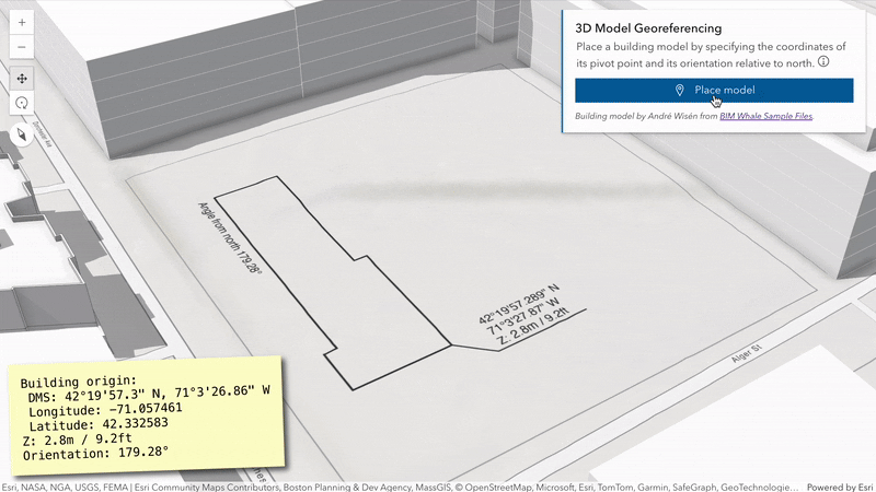
<calcite-notice id="placingComponent" class="notice" open="" slot="top-right">
<div slot="title">3D Model Georeferencing</div>
<div slot="message" style="margin: 0">
Place a building model by specifying the coordinates of its pivot point and its
orientation relative to north.
<calcite-icon icon="information" id="info-icon" scale="s"></calcite-icon>
<calcite-tooltip label="Info" reference-element="info-icon">
>Click the button below to load and place the building model. You can position it
manually, type in the coordinates and orientation from the site plan, or Copy+Paste
the values from the sticky note.<br /><br />
The coordinates can be entered as a latitude+longitude pair in DMS, DDM, or DD
format, or as separate longitude and latitude values.
<calcite-button id="placeModelButton" icon-start="pin-tear">Place model</calcite-button>
>Building model by André Wisén from
href="https://github.com/andrewisen/bim-whale-ifc-samples/tree/main/AdvancedProject"
>BIM Whale Sample Files</a
<div id="stickyNote" slot="bottom-left">
DMS: 42°19'57.3" N, 71°3'26.86" W<br />
Longitude: -71.057461<br />
Latitude: 42.332583<br />
Z: 2.8<span class="units">m</span> / 9.2<span class="units">ft</span><br />
Orientation: 89.28<span class="units">°</span>
const [SketchViewModel, GraphicsLayer, Point, Mesh] = await $arcgis.import([
"@arcgis/core/widgets/Sketch/SketchViewModel.js",
"@arcgis/core/layers/GraphicsLayer.js",
"@arcgis/core/geometry/Point.js",
"@arcgis/core/geometry/Mesh.js",
// Get the Scene component and wait for the view to initialize
const viewElement = document.querySelector("arcgis-scene");
await viewElement.viewOnReady();
// Create a client-side graphics layer for the SketchViewModel we use for uploading the 3D model to.
const graphics = new GraphicsLayer();
viewElement.map.add(graphics);
const sketchViewModel = new SketchViewModel({
sketchViewModel.on("create", (event) => {
if (event.state === "complete") {
sketchViewModel.update(event.graphic);
// Add interactivity to the UI.
const placeModelButton = document.getElementById("placeModelButton");
// Create a new abort controller for the new operation.
let placeModelAbortController = null;
placeModelButton.addEventListener("click", async () => {
// Cancel any pending placing operation.
placeModelAbortController?.abort();
// Reflect that the loading of the model is in process.
const { signal } = (placeModelAbortController = new AbortController());
// Create mesh from the 3D building model.
const mesh = await Mesh.createFromGLTF(
new Point(), // Origin of the model.
"https://developers.arcgis.com/javascript/latest/assets/sample-code/editing-coordinate-inputs/model.glb", // Url pointing to the 3D model file.
}, // In case of scenes in geographic or WebMercator spatial references, the vertexSpace needs to be set to "local".
// Reflect that the loading of the model has finished.
// Add the mesh to the SketchViewModel.
sketchViewModel.place(mesh);
// Updating buttons in UI.
function updateUI(creating) {
placeModelButton.loading = creating;
placeModelButton.disabled = creating;
placeModelButton.textContent = creating ? "Loading..." : "Place model";
placeModelButton.iconStart = creating ? null : "pin-tear";