Find features in a feature table which match an SQL query.
Use case
Query expressions can be used in ArcGIS to select a subset of features from a feature table. This is most useful in large or complicated data sets. A possible use case might be on a feature table marking the location of street furniture through a city. A user may wish to query by a TYPE column to return “benches”. In this sample, we query a U.S. state by STATE_NAME from a feature table containing all U.S. states.
How to use the sample
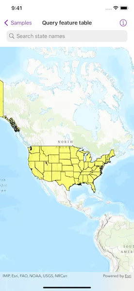
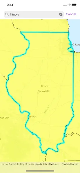
Input the name of a U.S. state into the text field. A query is performed and the matching features are highlighted or an error is returned.
How it works
- Create an
ServiceFeatureTableusing the URL of a feature service. - Create
QueryParameterswith awhereClausespecified. - Perform the query using
FeatureTable.queryFeatures(using:)on the service feature table. - When complete, the query will return a
FeatureQueryResultwhich can be iterated over to get the matching features.
Relevant API
- FeatureLayer
- FeatureQueryResult
- QueryParameters
- ServiceFeatureTable
About the data
This sample uses U.S. State polygon features from the USA 2016 Daytime Population feature service.
Tags
query, search
Sample code
QueryFeatureTableView.swift
// Copyright 2023 Esri//// Licensed under the Apache License, Version 2.0 (the "License");// you may not use this file except in compliance with the License.// You may obtain a copy of the License at////   https://www.apache.org/licenses/LICENSE-2.0//// Unless required by applicable law or agreed to in writing, software// distributed under the License is distributed on an "AS IS" BASIS,// WITHOUT WARRANTIES OR CONDITIONS OF ANY KIND, either express or implied.// See the License for the specific language governing permissions and// limitations under the License.
import ArcGISimport SwiftUI
struct QueryFeatureTableView: View {    @StateObject private var model = Model()
    /// The error shown in the error alert.    @State private var error: (any Error)?
    /// The text in the search bar.    @State private var searchBarText = ""
    var body: some View {        MapViewReader { mapViewProxy in            MapView(map: model.map)                .errorAlert(presentingError: $error)                // Makes the search bar.                .searchable(text: $searchBarText, prompt: "Search state names")                .autocorrectionDisabled()                .onSubmit(of: .search) {                    model.currentQuery = searchBarText                }                // A task that runs when the query text changes.                .task(id: model.currentQuery) {                    // Makes sure we have a query string.                    guard !model.currentQuery.isEmpty else { return }                    // Unselects all selected features.                    model.featureLayer.clearSelection()                    // Makes the query parameters and executes the query.                    let queryParameters = QueryParameters()                    queryParameters.whereClause = "upper(STATE_NAME) LIKE '%\(model.currentQuery.uppercased())%'"                    do {                        let queryResult = try await model.featureTable.queryFeatures(using: queryParameters)                        let queryResultFeatures = Array(queryResult.features())                        if !queryResultFeatures.isEmpty {                            // Displays the selection.                            model.featureLayer.selectFeatures(queryResultFeatures)                            // Zooms to the selected features.                            if let combinedExtent = GeometryEngine.combineExtents(of: queryResultFeatures.compactMap(\.geometry)) {                                await mapViewProxy.setViewpointGeometry(combinedExtent, padding: 25)                            }                        } else {                            // If the query returned no features then zooms                            // to the extent of the layer.                            if let layerExtent = model.featureLayer.fullExtent {                                await mapViewProxy.setViewpointGeometry(layerExtent, padding: 50)                            }                        }                    } catch {                        // Displays the error as an alert.                        self.error = error                    }                }        }    }}
private extension QueryFeatureTableView {    class Model: ObservableObject {        /// A map with a topographic basemap style.        let map: Map = {            let map = Map(basemapStyle: .arcGISTopographic)            map.initialViewpoint = Viewpoint(                center: Point(x: -11e6, y: 5e6, spatialReference: .webMercator),                scale: 9e7            )            return map        }()
        /// The text used in the query.        @Published var currentQuery = ""
        /// A feature table of US Daytime Population Census Tracts.        let featureTable = ServiceFeatureTable(            item: PortalItem(                portal: .arcGISOnline(connection: .anonymous),                id: .daytimePopulation            )        )
        /// A feature layer created from the service feature table.        let featureLayer: FeatureLayer
        init() {            // Creates a feature layer from feature table.            featureLayer = FeatureLayer(featureTable: featureTable)            // Shows the layer at all scales.            featureLayer.minScale = nil            featureLayer.maxScale = nil
            // Sets a new renderer on the feature layer.            let lineSymbol = SimpleLineSymbol(style: .solid, color: .black, width: 1)            let fillSymbol = SimpleFillSymbol(style: .solid, color: .yellow.withAlphaComponent(0.5), outline: lineSymbol)            featureLayer.renderer = SimpleRenderer(symbol: fillSymbol)            // Adds the feature layer to the map.            map.addOperationalLayer(featureLayer)        }    }}
private extension PortalItem.ID {    /// The portal item ID of a USA 2016 Daytime Population feature layer.    static var daytimePopulation: Self { Self("f01f0eda766344e29f42031e7bfb7d04")! }}
#Preview {    NavigationStack {        QueryFeatureTableView()    }}