<meta name="viewport" content="width=device-width, initial-scale=1, shrink-to-fit=no" />
<title>Masking effect using a custom layer view | Sample | ArcGIS Maps SDK for JavaScript</title>
<!-- Load the ArcGIS Maps SDK for JavaScript from CDN -->
<script type="module" src="https://js.arcgis.com/5.0/"></script>
<body class="calcite-mode-dark">
<arcgis-zoom slot="top-left"></arcgis-zoom>
<calcite-panel slot="top-right" id="controls" heading="Halo radius (px)">
<calcite-block expanded label="conrols block">
] = await $arcgis.import([
"@arcgis/core/core/Handles.js",
"@arcgis/core/views/2d/layers/BaseLayerView2D.js",
"@arcgis/core/layers/Layer.js",
"@arcgis/core/layers/FeatureLayer.js",
"@arcgis/core/layers/support/TileInfo.js",
"@arcgis/core/geometry/support/webMercatorUtils.js",
"@arcgis/core/geometry/Polygon.js",
"@arcgis/core/geometry/Polyline.js",
"@arcgis/core/geometry/Point.js",
"@arcgis/core/core/reactiveUtils.js",
const CustomLayerView2D = BaseLayerView2D.createSubclass({
constructor: function () {
// Maps from tile id to the image used by that tile.
this.tileContexts = new window.Map();
// The handles to the property watchers; we need to store them
// so that we can unwatch the properties when the layer view
this.watchHandles = new Handles();
// Set to true when the images in the tiles have become obsolete
// and must be regenerated. This is triggered by a change of
// layer.geometry, layer.color or layer.distance.
this.needsImageUpdate = false;
// Called when the layer is added to the map.
const layer = layerView.layer;
const handler = ([geometry, distance, color], [oldGeometry, oldDistance, oldColor]) => {
layerView.projectedGeometry = null;
layerView.needsImageUpdate = true;
layerView.requestRender();
if (geometry !== oldGeometry) {
if (layer.geometry.spatialReference.wkid === 4326) {
layerView.projectedGeometry = webMercatorUtils.geographicToWebMercator(
layerView.projectedGeometry = layer.geometry;
layerView.needsImageUpdate = true;
layerView.requestRender();
layerView.needsImageUpdate = true;
layerView.requestRender();
// Make sure that the effect is applied automatically at load time.
handler([this.layer.geometry, this.layer.distance, this.layer.color], [null, null, null]);
// Update and reapply the effect every time that the `geometry`, `distance`
// or `color` properties on the layer change.
() => [this.layer.geometry, this.layer.distance, this.layer.color],
// Called to regenerate a tile.
drawGeometry: function (ctx, bounds) {
ctx.globalCompositeOperation = "source-over";
const width = ctx.canvas.width;
const height = ctx.canvas.height;
// No geometry; entire map is unmasked.
if (!this.projectedGeometry) {
ctx.clearRect(0, 0, width, height);
// We mask the entire map; we will "carve" the unmasked area using
// an operation that subtracts opacity iteratively.
const c = this.layer.color;
ctx.fillStyle = "rgba(" + c[0] + ", " + c[1] + ", " + c[2] + ", 1)";
ctx.fillRect(0, 0, width, height);
// Every iteration reduces opacity by a constant term and each iteration acts
// on a progressively smaller region.
// The factor "3" is fairly arbitrary, but it works well with "destination-out".
// Lower values would cause a visible discontinuity between the fully illuminated
// area and the beginning of the shaded area.
const unmaskTerm = 3 / this.layer.distance;
ctx.globalCompositeOperation = "destination-out";
this.projectedGeometry.type === "polygon" ||
this.projectedGeometry.type === "polyline" ||
this.projectedGeometry.type === "extent"
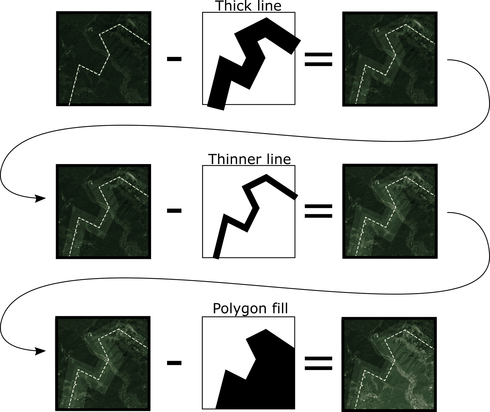
// Polygons, polylines and extents are carved using increasingly thinner lines
// and a single fill operation at the end.
// All geometry types are treated as rings.
this.projectedGeometry.type === "extent"
? Polygon.fromExtent(this.projectedGeometry).rings
: this.projectedGeometry.rings || this.projectedGeometry.paths;
// Rings are transformed to tile coordinates.
const transformed = rings.map((ring) => {
return ring.map((coords) => {
Math.round((width * (coords[0] - bounds[0])) / (bounds[2] - bounds[0])),
Math.round(height * (1 - (coords[1] - bounds[1]) / (bounds[3] - bounds[1]))),
// The rings are drawn as increasingly thinner lines; this produces
// a blurred edge around the unmasked area, so that transition from
// unmasked to masked is gradual.
for (let r = 1; r <= this.layer.distance; ++r) {
ctx.strokeStyle = "rgba(0, 0, 0, " + unmaskTerm + ")";
ctx.lineWidth = this.layer.distance + 1 - r;
for (let i = 0; i < transformed.length; ++i) {
const ring = transformed[i];
ctx.moveTo(ring[0][0], ring[0][1]);
for (let j = 1; j < ring.length; ++j) {
ctx.lineTo(ring[j][0], ring[j][1]);
// If it's not a polyline, meaning it's a polygon or an extent,
this.projectedGeometry.type !== "polyline" && ctx.closePath();
if (this.projectedGeometry.type !== "polyline") {
// If it's not a polyline, meaning it's a polygon or an extent,
// we carve the space occupied by the geometry using a fill
// operation; this is what fully unmask the geometry.
ctx.fillStyle = "rgba(0, 0, 0, 1)";
for (let i = 0; i < transformed.length; ++i) {
const ring = transformed[i];
ctx.moveTo(ring[0][0], ring[0][1]);
for (let j = 1; j < ring.length; ++j) {
ctx.lineTo(ring[j][0], ring[j][1]);
this.projectedGeometry.type === "point" ||
this.projectedGeometry.type === "multipoint"
// Points an multipoints are carved using increasingly smaller circles.
// The "point" case is equivalent to a "multipoint" with a single point.
this.projectedGeometry.type === "multipoint"
? this.projectedGeometry.points
: [[this.projectedGeometry.x, this.projectedGeometry.y]];
// Points are transformed to tile coordinates.
const transformed = points.map((coords) => {
Math.round((width * (coords[0] - bounds[0])) / (bounds[2] - bounds[0])),
Math.round(height * (1 - (coords[1] - bounds[1]) / (bounds[3] - bounds[1]))),
// The points are drawn using increasingly smaller circles.
for (let r = 1; r <= this.layer.distance; ++r) {
const size = this.layer.distance + 1 - r;
ctx.fillStyle = "rgba(0, 0, 0, " + unmaskTerm + ")";
for (let i = 0; i < transformed.length; ++i) {
const point = transformed[i];
ctx.arc(point[0], point[1], Math.round(size / 2), 0, 360);
// Creates the images for new tiles that don't have a texture yet, and destroys the images
// of tiles that are not on screen anymore.
manageTileImages: function () {
const tileIdSet = new Set();
// Create new images as needed.
for (let i = 0; i < this.tiles.length; ++i) {
const tile = this.tiles[i];
let ctx = this.tileContexts.get(tile.id);
if (this.needsImageUpdate) {
this.drawGeometry(ctx, tile.bounds);
const canvas = document.createElement("canvas");
canvas.width = this.layer.tileInfo.size[0];
canvas.height = this.layer.tileInfo.size[1];
ctx = canvas.getContext("2d");
this.tileContexts.set(tile.id, ctx);
this.drawGeometry(ctx, tile.bounds);
// Destroys unneeded images.
this.tileContexts.forEach((_, id) => {
if (!tileIdSet.has(id)) {
this.tileContexts.delete(id);
this.needsImageUpdate = false;
// Example of a render implementation that draws tile boundaries.
render: function (renderParameters) {
const tileSize = this.layer.tileInfo.size[0];
const state = renderParameters.state;
const pixelRatio = state.pixelRatio;
const width = state.size[0];
const height = state.size[1];
const context = renderParameters.context;
context.clearRect(0, 0, width * pixelRatio, height * pixelRatio);
// Apply rotation for everything that will be applied to the canvas.
if (state.rotation !== 0) {
context.translate(width * pixelRatio * 0.5, height * pixelRatio * 0.5);
context.rotate((state.rotation * Math.PI) / 180);
context.translate(-width * pixelRatio * 0.5, -height * pixelRatio * 0.5);
// Set the style for all the text.
context.globalAlpha = this.layer.color[3];
for (let i = 0; i < this.tiles.length; ++i) {
// Retrieve the current tile and its associated texture.
const tile = this.tiles[i];
const ctx = this.tileContexts.get(tile.id);
const screenScale = (tile.resolution / state.resolution) * pixelRatio;
state.toScreenNoRotation(coords, tile.coords);
// Destroy the shader program, the buffers and all the tile images.
this.watchHandles.removeAll();
// Required when using tiling; this methods is called every time that `this.tiles`
// changes, to give the derived class a chance to perform per-tile work as needed;
// This is where, for instance, tile data could be fetched from a server.
tilesChanged: function () {},
const CustomLayer = Layer.createSubclass({
tileInfo: TileInfo.create({ size: 512, spatialReference: { wkid: 3857 } }),
constructor: function () {
this.color = [0, 0, 0, 1];
createLayerView: function (view) {
if (view.type === "2d") {
return new CustomLayerView2D({
const viewElement = document.querySelector("arcgis-map");
const layer = new CustomLayer({
// The polygon geometry of a country is queried from a feature layer.
const countries = new FeatureLayer({
url: "https://services.arcgis.com/P3ePLMYs2RVChkJx/arcgis/rest/services/World_Countries_(Generalized)/FeatureServer/0",
const query = countries.createQuery();
query.where = "ISO = 'IT'";
countries.queryFeatures(query).then((result) => {
result.features[0].geometry,
// Other test geometries.
// Set up an automated loop that switches between the different geometries.
layer.geometry = geometries[i];
viewElement.goTo(layer.geometry).catch((error) => {
if (error.name !== "AbortError") {
// Switch to the next geometry in 3 seconds.
i = (i + 1) % geometries.length;
const slider = document.getElementById("haloSlider");
slider.addEventListener("calciteSliderChange", () => {
layer.distance = slider.value;