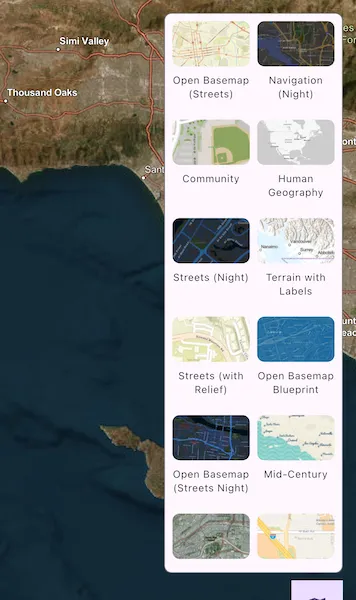
Change a map’s basemap. A basemap is beneath all layers on a map and is used to provide visual reference for the operational layers.
Use case
Basemaps should be selected contextually. For example, in maritime applications, it would be more appropriate to use a basemap of the world’s oceans as opposed to a basemap of the world’s streets.
How to use the sample
Tap the map button to show or hide the basemap gallery. Select a basemap in the gallery to apply it to the map.
How it works
- Create an
ArcGISMapobject with an initial basemap style. - Set the map to the
ArcGISMapViewControllerobject. - Create a
BasemapGalleryControllerand set the map to thegeoModelproperty. - Create a
BasemapGallerywidget using theBasemapGalleryController.
Relevant API
- ArcGISMap
- ArcGISMapViewController
- Basemap
- BasemapGallery
- BasemapGalleryController
Additional information
This sample uses the BasemapGallery toolkit component from the ArcGIS Maps SDK for Flutter Toolkit. The component supports selecting 2D and 3D basemaps from ArcGIS Online, a user-defined portal, or a collection of basemaps.
Tags
basemap, map
Sample code
set_basemap.dart
//// Copyright 2024 Esri//// Licensed under the Apache License, Version 2.0 (the "License");// you may not use this file except in compliance with the License.// You may obtain a copy of the License at////   https://www.apache.org/licenses/LICENSE-2.0//// Unless required by applicable law or agreed to in writing, software// distributed under the License is distributed on an "AS IS" BASIS,// WITHOUT WARRANTIES OR CONDITIONS OF ANY KIND, either express or implied.// See the License for the specific language governing permissions and// limitations under the License.//
import 'package:arcgis_maps/arcgis_maps.dart';import 'package:arcgis_maps_sdk_flutter_samples/common/common.dart';import 'package:arcgis_maps_toolkit/arcgis_maps_toolkit.dart';import 'package:flutter/material.dart';
class SetBasemap extends StatefulWidget {  const SetBasemap({super.key});
  @override  State<SetBasemap> createState() => _SetBasemapState();}
class _SetBasemapState extends State<SetBasemap> with SampleStateSupport {  // Create a controller for the map view and a map with an imagery basemap.  final _mapViewController = ArcGISMapView.createController();  final _arcGISMap = ArcGISMap.withBasemapStyle(BasemapStyle.arcGISImagery);  // Create a controller for the basemap gallery component.  late final BasemapGalleryController _basemapGalleryController;  // Track whether the basemap gallery panel is visible.  var _showBasemapGallery = false;
  @override  void initState() {    super.initState();    // Configure the gallery to update the map's basemap automatically.    _basemapGalleryController = BasemapGalleryController()      ..geoModel = _arcGISMap      ..viewStyle = BasemapGalleryViewStyle.automatic;  }
  @override  void dispose() {    _basemapGalleryController.dispose();    super.dispose();  }
  @override  Widget build(BuildContext context) {    return Scaffold(      body: LayoutBuilder(        builder: (context, constraints) {          // Use half of the available width for the gallery panel.          final galleryWidth = constraints.maxWidth / 2;
          return Stack(            children: [              // Show the map in the background.              ArcGISMapView(                controllerProvider: () => _mapViewController,                onMapViewReady: onMapViewReady,              ),              // Show the basemap gallery as an overlay panel.              if (_showBasemapGallery)                SafeArea(                  child: Align(                    alignment: Alignment.topRight,                    child: Container(                      width: galleryWidth,                      margin: const EdgeInsets.fromLTRB(16, 16, 16, 80),                      decoration: BoxDecoration(                        color: Theme.of(context).colorScheme.surface,                        border: Border.all(                          color: Theme.of(context).colorScheme.outline,                        ),                        borderRadius: BorderRadius.circular(8),                      ),                      child: Theme(                        data: Theme.of(context).copyWith(                          textTheme: Theme.of(context).textTheme.copyWith(                            bodySmall: Theme.of(                              context,                            ).textTheme.bodySmall?.copyWith(fontSize: 11),                          ),                        ),                        child: BasemapGallery(                          controller: _basemapGalleryController,                        ),                      ),                    ),                  ),                ),            ],          );        },      ),      // Toggle the basemap gallery panel.      floatingActionButton: FloatingActionButton(        onPressed: () =>            setState(() => _showBasemapGallery = !_showBasemapGallery),        shape: const RoundedRectangleBorder(),        child: const Icon(Icons.map),      ),    );  }
  void onMapViewReady() {    // Set the map's initial viewpoint.    _arcGISMap.initialViewpoint = Viewpoint.withLatLongScale(      latitude: 33.7,      longitude: -118.4,      scale: 1000000,    );
    // Assign the map to the map view controller.    _mapViewController.arcGISMap = _arcGISMap;  }}