Create a notification every time a given location data source has entered and/or exited a set of features or graphics.
Use case
Geotriggers can be used to notify users when they have entered or exited a geofence by monitoring a given set of features or graphics. They could be used to display contextual information to museum visitors about nearby exhibits, notify hikers when they have wandered off their desired trail, notify dispatchers when service workers arrive at a scene, or more.
How to use the sample
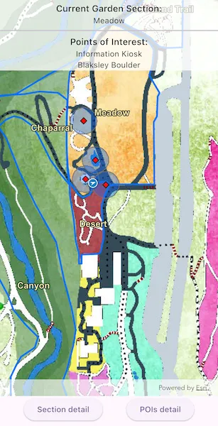
Observe a virtual walking tour of the Santa Barbara Botanic Garden. Information about the user’s current Garden Section, as well as information about nearby points of interest within 10 meters will display or be removed from the UI when the user enters or exits the buffer of each feature.
How it works
- Create a
GeotriggerFeedwith aLocationDataSourceclass (in this case, aSimulatedLocationDataSource). - Create a
FeatureFenceParametersclass from aServiceFeatureTable, a buffer distance at which to monitor each feature, anArcadeExpression, and a name for the specific geotrigger. - Create a
FenceGeotriggerwith the geotrigger feed, aFenceRuleType, and the fence parameters. - Create a
GeotriggerMonitorwith the fence geotrigger and callGeotriggerMonitor.start()to begin listening for events that meet theFenceRuleType. - When a
GeotriggerMonitor.geotriggerNotificationemits, capture theGeotriggerNotificationInfo. - For more information about the feature that triggered the notification, cast the
GeotriggerNotificationInfoto aFenceGeotriggerNotificationInfoand callFenceGeotriggerNotificationInfo.fenceGeoElement. - Depending on the
FenceGeotriggerNotificationInfo.fenceNotificationTypedisplay or hide information on the UI from theGeoElement’s attributes.
Relevant API
- ArcadeExpression
- FeatureFenceParameters
- FenceGeotrigger
- FenceGeotriggerNotificationInfo
- FenceRuleType
- GeoElement
- Geotrigger
- GeotriggerFeed
- GeotriggerMonitor
- GeotriggerNotificationInfo
- ServiceFeatureTable
- SimulatedLocationDataSource
About the data
This sample uses the Santa Barbara Botanic Garden Geotriggers Sample ArcGIS Online Web Map which includes a georeferenced map of the garden as well as select polygon and point features to denote garden sections and points of interest. Description text and attachment images in the feature layers were provided by the Santa Barbara Botanic Garden and more information can be found on the Garden Sections & Displays portion of their website. All assets are used with permission from the Santa Barbara Botanic Garden. For more information, visit the Santa Barbara Botanic Garden website.
Tags
alert, arcade, fence, geofence, geotrigger, location, navigation, notification, notify, routing, trigger
Sample code
// Copyright 2025 Esri//// Licensed under the Apache License, Version 2.0 (the "License");// you may not use this file except in compliance with the License.// You may obtain a copy of the License at////   https://www.apache.org/licenses/LICENSE-2.0//// Unless required by applicable law or agreed to in writing, software// distributed under the License is distributed on an "AS IS" BASIS,// WITHOUT WARRANTIES OR CONDITIONS OF ANY KIND, either express or implied.// See the License for the specific language governing permissions and// limitations under the License.//
import 'dart:async';import 'dart:collection';
import 'package:arcgis_maps/arcgis_maps.dart';import 'package:arcgis_maps_sdk_flutter_samples/common/common.dart';import 'package:flutter/material.dart';
class SetUpLocationDrivenGeotriggers extends StatefulWidget {  const SetUpLocationDrivenGeotriggers({super.key});
  @override  State<SetUpLocationDrivenGeotriggers> createState() =>      _SetUpLocationDrivenGeotriggersState();}
class _SetUpLocationDrivenGeotriggersState    extends State<SetUpLocationDrivenGeotriggers>    with SampleStateSupport {  // Create a controller for the map view.  final _mapViewController = ArcGISMapView.createController();  // A flag for when the map view is ready and controls can be used.  var _ready = false;  // The simulated location data source this sample will use.  final _locationDataSource = SimulatedLocationDataSource();
  // Geotrigger names  final _poiGeotriggerName = 'POI Geotrigger';  final _sectionGeotriggerName = 'Section Geotrigger';
  // Stream subscriptions for the geotrigger event changes.  final _streamSubscriptions =      <StreamSubscription<GeotriggerNotificationInfo>>[];
  // Maps to contain current section and POI features. Keys are the feature  // name, values are the full Feature. Using LinkedHashMaps to maintain insertion order.  final _currentSections =      <String, Feature>{} as LinkedHashMap<String, Feature>;  final _currentPois = <String, Feature>{} as LinkedHashMap<String, Feature>;
  // Service feature tables used for the FenceGeotriggers.  final _gardenSectionsTable = ServiceFeatureTable.withItem(    PortalItem.withPortalAndItemId(      portal: Portal.arcGISOnline(),      itemId: '1ba816341ea04243832136379b8951d9',    ),    layerId: 0,  );  final _gardenPoisTable = ServiceFeatureTable.withItem(    PortalItem.withPortalAndItemId(      portal: Portal.arcGISOnline(),      itemId: '7c6280c290c34ae8aeb6b5c4ec841167',    ),    layerId: 0,  );
  @override  void dispose() {    // Stop the location data source.    _locationDataSource.stop();
    // Cancel the geotrigger event subscriptions.    for (final subscription in _streamSubscriptions) {      subscription.cancel();    }    _streamSubscriptions.clear();
    super.dispose();  }
  @override  Widget build(BuildContext context) {    return Scaffold(      body: SafeArea(        top: false,        left: false,        right: false,        child: Stack(          children: [            Column(              children: [                Expanded(                  // Add a map view to the widget tree and set a controller.                  child: ArcGISMapView(                    controllerProvider: () => _mapViewController,                    onMapViewReady: onMapViewReady,                  ),                ),                Row(                  mainAxisAlignment: MainAxisAlignment.spaceEvenly,                  children: [                    // Button to show the details of the current Section.                    ElevatedButton(                      onPressed: _currentSections.isEmpty                          ? null                          : () => showFeatureDetail(                              context: context,                              feature: _currentSections.values.last,                            ),                      child: const Text('Section detail'),                    ),                    // Button to show the details of the nearby POI.                    ElevatedButton(                      onPressed: _currentPois.isEmpty                          ? null                          : () => showFeatureDetail(                              context: context,                              feature: _currentPois.values.last,                            ),                      child: const Text('POI detail'),                    ),                  ],                ),              ],            ),            // Current Section and POIs display.            Column(              children: [                ColoredBox(                  color: const Color.fromARGB(200, 255, 255, 255),                  child: SafeArea(                    left: false,                    right: false,                    child: Column(                      children: [                        buildCurrentGardenSection(context),                        const Divider(thickness: 2),                        buildCurrentPois(context),                      ],                    ),                  ),                ),              ],            ),            // Display a progress indicator and prevent interaction until state is ready.            LoadingIndicator(visible: !_ready),          ],        ),      ),    );  }
  Future<void> onMapViewReady() async {    // Create the map based on a webmap and add it to the MapView.    final map = ArcGISMap.withUri(      Uri.parse(        'https://www.arcgis.com/home/item.html?id=6ab0e91dc39e478cae4f408e1a36a308',      ),    );    _mapViewController.arcGISMap = map;
    // Set the SimulatedLocationDataSource's simulated path, then add it to the    // MapView's LocationDisplay.    _locationDataSource.setLocationsWithPolyline(_createSamplePath());    _mapViewController.locationDisplay.dataSource = _locationDataSource;    await _locationDataSource.start();
    // Setup the geotriggers.    await _setupGeotriggers();
    // Set the ready state variable to true to enable the sample UI.    setState(() => _ready = true);  }
  // Sets up the Geotriggers, GeotriggerMonitors, and listens for Geotrigger events.  Future<void> _setupGeotriggers() async {    // Setup the points of interest Geotrigger monitor.    await createGeotriggerMonitor(      featureTable: _gardenPoisTable,      bufferSize: 10,      name: _poiGeotriggerName,    );
    // Set up the sections Geotrigger monitor.    await createGeotriggerMonitor(      featureTable: _gardenSectionsTable,      name: _sectionGeotriggerName,    );  }
  // Creates a GeotriggerMonitor using the provided ServiceFeatureTable and  // optional buffer size. The stream for changing events will be listened to,  // and the monitor started.  Future<void> createGeotriggerMonitor({    required ServiceFeatureTable featureTable,    required String name,    double bufferSize = 0.0,  }) async {    // Set up the fence parameters    final fenceParameters = FeatureFenceParameters(      featureTable: featureTable,      bufferDistance: bufferSize,    );
    // Create the geotrigger. The Arcade expression provides a convenient way to    // get the name of the triggering feature.    final geotrigger = FenceGeotrigger(      feed: LocationGeotriggerFeed(locationDataSource: _locationDataSource),      ruleType: FenceRuleType.enterOrExit,      fenceParameters: fenceParameters,      messageExpression: ArcadeExpression(expression: r'$fencefeature.name'),      name: name,    );
    // Create the GeotriggerMonitor and listen to the onGeotriggerNotificationEvent stream.    final monitor = GeotriggerMonitor(geotrigger);    final subscription = monitor.onGeotriggerNotificationEvent.listen(      handleGeotriggerEvent,    );    _streamSubscriptions.add(subscription);
    // Start monitoring the Geotrigger.    await monitor.start();  }
  // Handle geotrigger event changes sent from the monitors.  void handleGeotriggerEvent(GeotriggerNotificationInfo info) {    final fenceInfo = info as FenceGeotriggerNotificationInfo;
    // Set which feature list to update based on which monitor triggered this event.    final featureMap =        fenceInfo.geotriggerMonitor.geotrigger.name == _poiGeotriggerName        ? _currentPois        : _currentSections;
    // Add or remove the feature name from the list based on event type.    setState(() {      switch (fenceInfo.fenceNotificationType) {        case FenceNotificationType.entered:          featureMap[fenceInfo.message] = fenceInfo.fenceGeoElement as Feature;        case FenceNotificationType.exited:          featureMap.remove(fenceInfo.message);      }    });  }
  // Builds the widget to display the current Section.  Widget buildCurrentGardenSection(BuildContext context) {    return Column(      children: [        Text(          'Current Garden Section:',          style: Theme.of(context).textTheme.titleMedium,        ),        Row(          mainAxisAlignment: MainAxisAlignment.center,          children: [            Text(              _currentSections.isEmpty                  ? 'Not currently in a section'                  : _currentSections.keys.last,            ),          ],        ),      ],    );  }
  // Builds the widget showing the list of nearby POIs.  Widget buildCurrentPois(BuildContext context) {    return Column(      children: [        Text(          'Points of Interest:',          style: Theme.of(context).textTheme.titleMedium,        ),        Column(          mainAxisAlignment: MainAxisAlignment.center,          children: _currentPois.isEmpty              ? [const Text('No Points of Interest nearby')]              : _currentPois.keys.map((featureName) {                  return Text(featureName);                }).toList(),        ),      ],    );  }
  // Display the feature details in a Popup view in a modal bottom sheet.  void showFeatureDetail({    required BuildContext context,    required Feature feature,  }) {    if (!mounted) return;
    showModalBottomSheet<void>(      context: context,      isScrollControlled: true,      useSafeArea: true,      builder: (_) => SizedBox(        height: MediaQuery.sizeOf(context).height * 0.7,        child: FeaturePopupView(          feature: feature,          onClose: () => Navigator.of(context).maybePop(),        ),      ),    );  }
  // Creates the path used for the SimulatedLocationDataSource.  Polyline _createSamplePath() {    final polylineCoordinates = [      [-119.709881177746, 34.4570041646846],      [-119.709875813328, 34.4570152227745],      [-119.709869107805, 34.4570240692453],      [-119.709859720074, 34.4570351273326],      [-119.709853014551, 34.4570539260775],      [-119.709847650133, 34.4570760422426],      [-119.709848991238, 34.4570926293626],      [-119.70985569676, 34.4571103222869],      [-119.709873131119, 34.4571202745552],      [-119.709889224373, 34.4571302268223],      [-119.709902635418, 34.4571357558591],      [-119.709910682045, 34.4571600836165],      [-119.709910682045, 34.4571744591062],      [-119.709902635418, 34.4571833055602],      [-119.709889224373, 34.4571910462067],      [-119.70988251885, 34.4571965752394],      [-119.70988251885, 34.4572032100782],      [-119.709889224373, 34.4572175855605],      [-119.709898612104, 34.4572264320099],      [-119.709912023149, 34.4572341726524],      [-119.709901294313, 34.4572419132941],      [-119.709895929895, 34.4572507597409],      [-119.709897271, 34.4572596061868],      [-119.709902635418, 34.4572728758539],      [-119.709902635418, 34.4572828281028],      [-119.70990934094, 34.457294991961],      [-119.709912023149, 34.4573038384022],      [-119.709886542164, 34.4573115790375],      [-119.709861061178, 34.4573248486963],      [-119.709843626819, 34.4573414357669],      [-119.709836921297, 34.4573668692686],      [-119.709843626819, 34.4573934085666],      [-119.709827533565, 34.4574055724087],      [-119.709791323744, 34.4574188420525],      [-119.709749749504, 34.4574332174977],      [-119.709709516369, 34.4574431697275],      [-119.709734997354, 34.4574807670294],      [-119.709748062646, 34.4575248306656],      [-119.709757450378, 34.4575635337324],      [-119.709770861423, 34.457600025179],      [-119.709785613572, 34.4576387282109],      [-119.70980573014, 34.4576730080242],      [-119.709815117871, 34.4577117110223],      [-119.709821823394, 34.4577504140025],      [-119.709821823394, 34.4577869053674],      [-119.709821823394, 34.4578256083127],      [-119.70981780008, 34.4578609938471],      [-119.709819141185, 34.457906331541],      [-119.70981460448, 34.4579890675855],      [-119.709818627793, 34.4580675790658],      [-119.70982667442, 34.4581118108532],      [-119.709832038838, 34.4581471962662],      [-119.709834721047, 34.4581947453913],      [-119.709836062152, 34.4582323423548],      [-119.709834721047, 34.4582787856393],      [-119.709805216748, 34.4583429215611],      [-119.709759619195, 34.4584026342716],      [-119.709700610597, 34.4584612411497],      [-119.709645400048, 34.4585103926263],      [-119.709566274882, 34.4585457778704],      [-119.709493855239, 34.4585944325566],      [-119.709458986522, 34.458622077252],      [-119.709424117805, 34.4586198656767],      [-119.709386566878, 34.4586110193749],      [-119.70935438037, 34.4586110193749],      [-119.709339628221, 34.4586231830396],      [-119.709324876071, 34.4586585682359],      [-119.709306100608, 34.4586862129101],      [-119.709269890786, 34.4587171749343],      [-119.709244409801, 34.4587238096523],      [-119.709229657651, 34.4587293385835],      [-119.709212223293, 34.4587459253751],      [-119.70919076562, 34.4587945799446],      [-119.709174672366, 34.4588503400161],      [-119.709157238008, 34.4589288506865],      [-119.709153214694, 34.4589951976744],      [-119.709155896903, 34.4590449578807],      [-119.70916394353, 34.4590958238387],      [-119.709186742307, 34.4591323146156],      [-119.709218928815, 34.4591621706939],      [-119.709237704278, 34.4591831805204],      [-119.709241727592, 34.4592252001575],      [-119.709238133851, 34.459258658624],      [-119.709219358388, 34.4592796684262],      [-119.709207288447, 34.4592962551085],      [-119.709208629552, 34.4593084186733],      [-119.709271661463, 34.4593791884701],      [-119.709310553494, 34.4594267368937],      [-119.709330670062, 34.4594510639836],      [-119.709353468838, 34.4595008239182],      [-119.70936285657, 34.4595362087426],      [-119.709423221989, 34.4595943612845],      [-119.709455408497, 34.4596297460692],      [-119.709487595005, 34.459665130839],      [-119.709507711573, 34.4596817174446],      [-119.709523804827, 34.4596861405389],      [-119.709557332439, 34.4596894578594],      [-119.709586836739, 34.4596894578594],      [-119.709593542261, 34.4596772943501],      [-119.709590860052, 34.4596496500041],      [-119.709572084589, 34.4595777746615],      [-119.709566720171, 34.4595313320996],      [-119.709578790112, 34.4595136396883],      [-119.709590860052, 34.4594992646013],      [-119.709627069874, 34.4594882068404],      [-119.709675349636, 34.4595567649343],      [-119.709735699339, 34.4596197941001],      [-119.709775932474, 34.4596795058974],      [-119.709802754564, 34.4597126790997],      [-119.709832258863, 34.4597359003334],      [-119.70986712758, 34.4597171021923],      [-119.70986980979, 34.4596839289918],      [-119.709865786476, 34.4596308518435],      [-119.709876515312, 34.4595788804365],      [-119.70988187973, 34.4595346494263],      [-119.709879197521, 34.4594926299449],      [-119.709852375431, 34.4594539277723],      [-119.709806777878, 34.4593953215911],      [-119.709767885847, 34.4593212344729],      [-119.709720947189, 34.4592195028005],      [-119.709708720088, 34.4591478732967],      [-119.709710061193, 34.4591058536206],      [-119.709707378984, 34.459079314867],      [-119.709652393699, 34.4590262373344],      [-119.709617524982, 34.4589499383221],      [-119.709626771268, 34.4588695962162],      [-119.709683097658, 34.4588032491285],      [-119.709730036316, 34.4587391135603],      [-119.709759540615, 34.4586993052518],      [-119.7097850216, 34.4586650258598],      [-119.710059948024, 34.4587744987075],      [-119.710104204473, 34.4587932970608],      [-119.710128443889, 34.4587649224307],      [-119.71019415801, 34.4587096331253],      [-119.710273283176, 34.4586731421637],      [-119.71031619852, 34.4586532379961],      [-119.710367160491, 34.4586023717685],      [-119.710392641477, 34.4585747270665],      [-119.710432874612, 34.4585083797445],      [-119.710471766643, 34.4584453497398],      [-119.710505294256, 34.4584165991955],      [-119.710575487456, 34.4583689119728],      [-119.710705574593, 34.4583136224052],      [-119.710780676446, 34.4582627559707],      [-119.710839685044, 34.4582030431601],      [-119.710895995717, 34.4581546042213],      [-119.710948298793, 34.458095997128],      [-119.710988531928, 34.4580263320391],      [-119.711015354018, 34.4579511379096],      [-119.711011330705, 34.4579102234284],      [-119.710985849719, 34.4578847900921],      [-119.710946957688, 34.4578715205223],      [-119.710779319625, 34.4578847900921],      [-119.71073908649, 34.4578847900921],      [-119.7107122644, 34.4578604625458],      [-119.71069751225, 34.4578295002039],      [-119.710674713473, 34.4578095958352],      [-119.710642526965, 34.4577996436491],      [-119.710614363771, 34.457830606002],      [-119.71057547174, 34.4578571451526],      [-119.710539261918, 34.4578737321174],      [-119.71049500547, 34.4578858958895],      [-119.710452090125, 34.4578836842947],      [-119.710413198095, 34.4578748379149],      [-119.710375647168, 34.4578527219614],      [-119.710336755138, 34.4578350291944],      [-119.710299204211, 34.4578107016336],      [-119.71027506433, 34.4577885856631],      [-119.710269605616, 34.4577886418169],      [-119.710240101317, 34.4577510446536],      [-119.710198527077, 34.4576758502763],      [-119.710154270628, 34.4575984442288],      [-119.710112696389, 34.4575265671206],      [-119.710044300059, 34.4574381029023],      [-119.709978842634, 34.4573543166616],      [-119.709966772693, 34.4573410470074],      [-119.709972137111, 34.4573200367174],      [-119.70997481932, 34.4573023438375],      [-119.709973478216, 34.4572846509538],      [-119.709970796007, 34.457259217427],      [-119.709931903976, 34.4572348896984],      [-119.709914469617, 34.4572337838924],      [-119.709893011945, 34.4572171968005],      [-119.709884965318, 34.4571972922858],      [-119.709902232039, 34.4571821133624],      [-119.70991161977, 34.457167737874],      [-119.709907596457, 34.4571389868898],      [-119.709919666397, 34.4571235055865],      [-119.709922348606, 34.4571047068572],      [-119.709918325293, 34.4570836965077],      [-119.709919666397, 34.4570648977695],      [-119.70992637192, 34.4570516280694],      [-119.709933077442, 34.4570339351326],      [-119.709935759651, 34.4570151363832],      [-119.709927713024, 34.4570062899114],      [-119.70991161977, 34.4570018666751],      [-119.709883456576, 34.4570040782933],    ];
    final polylineBuilder = PolylineBuilder(      spatialReference: SpatialReference.wgs84,    );    for (final coordinate in polylineCoordinates) {      polylineBuilder.addPointXY(x: coordinate.first, y: coordinate.last);    }
    return polylineBuilder.toGeometry() as Polyline;  }}