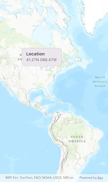
Show a callout with the latitude and longitude of user-tapped points.
Use case
Callouts are used to display temporary detail content on a map. You can display text and arbitrary UI controls in callouts.
How to use the sample
Tap anywhere on the map. A callout showing the WGS84 coordinates for the tapped point will appear.
How it works
- Create an
ArcGISMapand set it on anArcGISMapView. - Configure an
onTapevent handler on theArcGISMapView. - Project the tapped location to WGS84 using
GeometryEngine.project. - Display the tapped location’s coordinates in a callout with
ArcGISMapViewController.callout.showAt.
Relevant API
- ArcGISMapView
- ArcGISMapViewController.callout
- GeometryEngine.project
Tags
balloon, bubble, callout, flyout, flyover, info window, popup, tap
Sample code
show_callout.dart
// Copyright 2026 Esri//// Licensed under the Apache License, Version 2.0 (the "License");// you may not use this file except in compliance with the License.// You may obtain a copy of the License at////   https://www.apache.org/licenses/LICENSE-2.0//// Unless required by applicable law or agreed to in writing, software// distributed under the License is distributed on an "AS IS" BASIS,// WITHOUT WARRANTIES OR CONDITIONS OF ANY KIND, either express or implied.// See the License for the specific language governing permissions and// limitations under the License.//
import 'package:arcgis_maps/arcgis_maps.dart';import 'package:arcgis_maps_sdk_flutter_samples/common/common.dart';import 'package:flutter/material.dart';
class ShowCallout extends StatefulWidget {  const ShowCallout({super.key});
  @override  State<ShowCallout> createState() => _ShowCalloutState();}
class _ShowCalloutState extends State<ShowCallout> with SampleStateSupport {  // Create a controller for the map view.  final _mapViewController = ArcGISMapView.createController();
  @override  Widget build(BuildContext context) {    return Scaffold(      // Add a map view to the widget tree and set a controller.      body: ArcGISMapView(        controllerProvider: () => _mapViewController,        onMapViewReady: onMapViewReady,        onTap: onTap,      ),    );  }
  void onMapViewReady() {    // Create a map with a topographic basemap style.    final map = ArcGISMap.withBasemapStyle(.arcGISTopographic);
    // Set the map on the map view controller.    _mapViewController.arcGISMap = map;  }
  void onTap(Offset offset) {    // Convert screen point to map point.    final mapPoint = _mapViewController.screenToLocation(screen: offset);    if (mapPoint == null) return;
    // Project the tapped point to WGS84 for coordinate formatting.    final tapLocation =        GeometryEngine.project(              mapPoint,              outputSpatialReference: SpatialReference.wgs84,            )            as ArcGISPoint;
    // Format the coordinates using the CoordinateFormatter.toLatitudeLongitude.    final coordinateText = CoordinateFormatter.toLatitudeLongitude(      point: tapLocation,      format: LatitudeLongitudeFormat.decimalDegrees,      decimalPlaces: 2,    );
    // Show the coordinates in a callout.    _mapViewController.callout.showAt(      mapPoint,      title: 'Location',      detail: coordinateText,      style: ThemedCalloutStyle.themed(context),    );  }}