Specify a map’s spatial reference.
Use case
Choosing the correct spatial reference is important for ensuring accurate projection of data points to a map.
How to use the sample
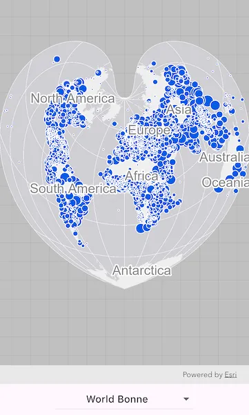
Pan and zoom around the map. Observe how the map is displayed in the World Bonne spatial reference. Pick a different spatial reference and see the map reprojected.
How it works
- Instantiate an
ArcGISMapobject using a spatial reference. - Instantiate a
Basemapobject using anArcGISMapImageLayerobject. - Set the basemap to the map.
- Set the map to an
ArcGISMapViewControllerobject. - Change the map’s spatial reference using the
setSpatialReferencemethod.
The ArcGIS map image layer will reproject into the spatial reference set to the map (such as World Bonne (WKID: 54024)), and not the map service’s default spatial reference.
Relevant API
- ArcGISMap
- ArcGISMapImageLayer
- ArcGISMapView
- ArcGISMapViewController
- Basemap
- SpatialReference
About the data
This sample uses a World Cities Population map service that displays world cities symbolized based on population.
Additional information
Operational layers will automatically project to this spatial reference when possible. There are 3 kinds of layer reprojection behaviors:
- Reprojected on device (on-the-fly reprojection), such as a
FeatureLayercreated from a mobile geodatabase - Reprojected from the service, such as an
ArcGISMapImageLayer - Not able to reproject, such as an
ArcGISTiledLayerwith defined spatial reference in its tile cache. These layers might be able to reproject in a future update.
For more information, check out the API reference doc for setSpatialReference method.
Tags
coordinate system, project, projection, spatial reference, Web Mercator, WGS84, WKID
Sample code
// Copyright 2026 Esri//// Licensed under the Apache License, Version 2.0 (the "License");// you may not use this file except in compliance with the License.// You may obtain a copy of the License at////   https://www.apache.org/licenses/LICENSE-2.0//// Unless required by applicable law or agreed to in writing, software// distributed under the License is distributed on an "AS IS" BASIS,// WITHOUT WARRANTIES OR CONDITIONS OF ANY KIND, either express or implied.// See the License for the specific language governing permissions and// limitations under the License.//
import 'package:arcgis_maps/arcgis_maps.dart';import 'package:arcgis_maps_sdk_flutter_samples/common/common.dart';import 'package:flutter/material.dart';
class SetSpatialReference extends StatefulWidget {  const SetSpatialReference({super.key});
  @override  State<SetSpatialReference> createState() => _SetSpatialReferenceState();}
class _SetSpatialReferenceState extends State<SetSpatialReference>    with SampleStateSupport {  // Create a controller for the map view.  final _mapViewController = ArcGISMapView.createController();
  // A flag for when the map view is ready and controls can be used.  var _ready = false;
  // The spatial reference currently selected in the dropdown.  SpatialReference? _selectedSpatialReference;
  // Stores the spatial references available in the dropdown.  final _spatialReferences = <DropdownMenuEntry<SpatialReference>>[];
  @override  void initState() {    super.initState();
    // Add spatial references to the dropdown menu.    _spatialReferences.addAll([      DropdownMenuEntry(        value: SpatialReference(wkid: 102299),        label: 'Berghaus Star AAG',      ),      DropdownMenuEntry(value: SpatialReference(wkid: 54050), label: 'Fuller'),      DropdownMenuEntry(        value: SpatialReference(wkid: 27200),        label: 'New Zealand Map Grid',      ),      DropdownMenuEntry(        value: SpatialReference(wkid: 102018),        label: 'North Pole Stereographic',      ),      DropdownMenuEntry(        value: SpatialReference(wkid: 54090),        label: 'Peirce Quincuncial',      ),      DropdownMenuEntry(        value: SpatialReference(wkid: 32610),        label: 'UTM Zone 10 N',      ),      DropdownMenuEntry(        value: SpatialReference(wkid: 54024),        label: 'World Bonne',      ),      DropdownMenuEntry(        value: SpatialReference(wkid: 54052),        label: 'World Goode Homolosine',      ),      DropdownMenuEntry(        value: SpatialReference(wkid: 102038),        label: 'World Orthographic',      ),      DropdownMenuEntry(        value: SpatialReference.webMercator,        label: 'Web Mercator',      ),      DropdownMenuEntry(value: SpatialReference.wgs84, label: 'WGS 84'),    ]);  }
  @override  Widget build(BuildContext context) {    return Scaffold(      body: SafeArea(        top: false,        left: false,        right: false,        child: Stack(          children: [            Column(              children: [                Expanded(                  // Add a map view to the widget tree and set a controller.                  child: ArcGISMapView(                    controllerProvider: () => _mapViewController,                    onMapViewReady: onMapViewReady,                  ),                ),                Center(                  // A dropdown button to select the spatial reference.                  child: DropdownMenu(                    dropdownMenuEntries: _spatialReferences,                    textAlign: TextAlign.center,                    onSelected: (spatialReference) {                      // Return if no spatial reference was selected.                      if (spatialReference == null) return;
                      // Update the selected spatial reference.                      setState(() {                        _selectedSpatialReference = spatialReference;                      });
                      // Set the map's spatial reference to the selected value.                      _mapViewController.arcGISMap?.setSpatialReference(                        spatialReference,                      );                    },                    initialSelection: _selectedSpatialReference,                  ),                ),              ],            ),            // Display a progress indicator and prevent interaction until state is ready.            LoadingIndicator(visible: !_ready),          ],        ),      ),    );  }
  void onMapViewReady() {    // Create a map using the World Bonne spatial reference.    final map = ArcGISMap(spatialReference: SpatialReference(wkid: 54024));
    // Create a map image layer.    final mapImageLayer = ArcGISMapImageLayer.withUri(      Uri.parse(        'https://sampleserver6.arcgisonline.com/arcgis/rest/services/SampleWorldCities/MapServer',      ),    );
    // Create a basemap from the map image layer.    map.basemap = Basemap.withBaseLayer(mapImageLayer);
    // Set the map to the map view controller.    _mapViewController.arcGISMap = map;
    // Set the initial selected spatial reference and enable the sample UI.    setState(() {      _selectedSpatialReference = map.spatialReference;      _ready = true;    });  }}