A multipart geometry can be densified by adding interpolated points at regular intervals. Generalizing multipart geometry simplifies it while preserving its general shape. Densifying a multipart geometry adds more vertices at regular intervals.
Use case
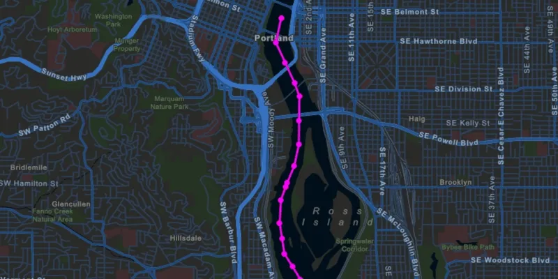
The sample shows a polyline representing a ship’s location at irregular intervals. The density of vertices along the ship’s route is appropriate to represent the path of the ship at the sample map view’s initial scale. However, that level of detail may be too great if you wanted to show a polyline of the ship’s movement down the whole of the Willamette river. Then, you might consider generalizing the polyline to still faithfully represent the ship’s passage on the river without having an overly complicated geometry.
Densifying a multipart geometry can be used to more accurately represent curved lines or to add more regularity to the vertices making up a multipart geometry.
How to use the sample
Use the sliders to control the parameters of the densify and generalize methods. You can deselect the checkboxes for either method to remove its effect from the result polyline. You can also hide the result to only see the original by deselecting the “Show result” checkbox.
How it works
- Use the static method
GeometryEngine.densify(polyline, maxSegmentLength)to densify the polyline object. The resulting polyline object will have more points along the line, so that there are no points greater thanmaxSegmentLengthfrom the next point. - Use the static method
GeometryEngine.generalize(polyline, maxDeviation, true)to generalize the polyline object. The resulting polyline object will have points shifted from the original line to simplify the shape. None of these points can deviate farther from the original line thanmaxDeviation. The last parameter,removeDegenerateParts, will clean up extraneous parts of a multipart geometry. This will have no effect in this sample as the polyline does not contain extraneous parts. - Note that
maxSegmentLengthandmaxDeviationare in the units of the geometry’s coordinate system. In this example, a cartesian coordinate system is used and at a small enough scale that geodesic distances are not required.
Relevant API
- GeometryEngine
- Multipoint
- Point
- PointCollection
- Polyline
- SimpleLineSymbol
- SpatialReference
Tags
densify, Edit and Manage Data, generalize, simplify
Sample code
/* * Copyright 2018 Esri. * * Licensed under the Apache License, Version 2.0 (the "License"); you may not * use this file except in compliance with the License. You may obtain a copy of * the License at * * http://www.apache.org/licenses/LICENSE-2.0 * * Unless required by applicable law or agreed to in writing, software * distributed under the License is distributed on an "AS IS" BASIS, WITHOUT * WARRANTIES OR CONDITIONS OF ANY KIND, either express or implied. See the * License for the specific language governing permissions and limitations under * the License. */
package com.esri.samples.densify_and_generalize;
import javafx.fxml.FXML;import javafx.scene.control.CheckBox;import javafx.scene.control.Slider;import javafx.scene.paint.Color;
import com.esri.arcgisruntime.ArcGISRuntimeEnvironment;import com.esri.arcgisruntime.geometry.GeometryEngine;import com.esri.arcgisruntime.geometry.Multipoint;import com.esri.arcgisruntime.geometry.Point;import com.esri.arcgisruntime.geometry.PointCollection;import com.esri.arcgisruntime.geometry.Polyline;import com.esri.arcgisruntime.geometry.SpatialReference;import com.esri.arcgisruntime.mapping.ArcGISMap;import com.esri.arcgisruntime.mapping.BasemapStyle;import com.esri.arcgisruntime.mapping.view.Graphic;import com.esri.arcgisruntime.mapping.view.GraphicsOverlay;import com.esri.arcgisruntime.mapping.view.MapView;import com.esri.arcgisruntime.symbology.SimpleLineSymbol;import com.esri.arcgisruntime.symbology.SimpleMarkerSymbol;
public class DensifyAndGeneralizeController {
  @FXML private MapView mapView;  @FXML private Slider maxSegmentLengthSlider;  @FXML private Slider maxDeviationSlider;  @FXML private CheckBox resultVisibilityCheckBox;  @FXML private CheckBox densifyCheckBox;  @FXML private CheckBox generalizeCheckBox;
  private Polyline originalPolyline;  private Graphic resultPointsGraphic;  private Graphic resultPolylineGraphic;
  @FXML  public void initialize() {    // authentication with an API key or named user is required to access basemaps and other location services    String yourAPIKey = System.getProperty("apiKey");    ArcGISRuntimeEnvironment.setApiKey(yourAPIKey);
    // create a map with the streets night basemap style    ArcGISMap map = new ArcGISMap(BasemapStyle.ARCGIS_STREETS_NIGHT);
    // set the map to the map view    mapView.setMap(map);
    // create a graphics overlay    GraphicsOverlay graphicsOverlay = new GraphicsOverlay();    mapView.getGraphicsOverlays().add(graphicsOverlay);
    // create some points along a river for the original geometry    PointCollection points = createShipPoints();
    // show the original points as red dots on the map    Multipoint originalMultipoint = new Multipoint(points);    Graphic originalPointsGraphic = new Graphic(originalMultipoint, new SimpleMarkerSymbol(SimpleMarkerSymbol.Style.CIRCLE,      Color.RED, 7));    graphicsOverlay.getGraphics().add(originalPointsGraphic);
    // show a dotted red line connecting the original points    originalPolyline = new Polyline(points);    Graphic originalPolylineGraphic = new Graphic(originalPolyline, new SimpleLineSymbol(SimpleLineSymbol.Style.DOT,        Color.RED, 3));    graphicsOverlay.getGraphics().add(originalPolylineGraphic);
    // show the result (densified and generalized) points as magenta dots on the map    resultPointsGraphic = new Graphic();    resultPointsGraphic.setSymbol(new SimpleMarkerSymbol(SimpleMarkerSymbol.Style.CIRCLE, Color.MAGENTA, 7));    graphicsOverlay.getGraphics().add(resultPointsGraphic);
    // connect the result points with a magenta line    resultPolylineGraphic = new Graphic();    resultPolylineGraphic.setSymbol(new SimpleLineSymbol(SimpleLineSymbol.Style.SOLID, Color.MAGENTA, 3));    graphicsOverlay.getGraphics().add(resultPolylineGraphic);
    // update the densified/generalized parameters when the slider values change    maxSegmentLengthSlider.valueProperty().addListener(o -> updateGeometry());    maxDeviationSlider.valueProperty().addListener(o -> updateGeometry());
    // set initial values    maxSegmentLengthSlider.setValue(100);    maxDeviationSlider.setValue(10);
    // zoom to the original polyline    mapView.setViewpointGeometryAsync(originalPolyline.getExtent(), 100);  }
  /**   * Called when any of the densify/generalize option values are changed. Applies the densify and generalize   * operations to the original polyline and updates the result graphics with the result geometry.   */  @FXML  private void updateGeometry() {    Polyline polyline = originalPolyline;    if (generalizeCheckBox.isSelected()) {      polyline = (Polyline) GeometryEngine.generalize(polyline, maxDeviationSlider.getValue(), true);    }    if (densifyCheckBox.isSelected()) {      polyline = (Polyline) GeometryEngine.densify(polyline, maxSegmentLengthSlider.getValue());    }    resultPolylineGraphic.setGeometry(polyline);    Multipoint multipoint = new Multipoint(polyline.getParts().getPartsAsPoints());    resultPointsGraphic.setGeometry(multipoint);  }
  /**   * Toggles the visibility of the result graphics depending on the state of the result visibility checkbox.   */  @FXML  private void updateResultVisibility() {    resultPolylineGraphic.setVisible(resultVisibilityCheckBox.isSelected());    resultPointsGraphic.setVisible(resultVisibilityCheckBox.isSelected());  }
  /**   * Creates a collection of points along the Willamette River in Portland, OR.   *   * @return points   */  private PointCollection createShipPoints() {    PointCollection points = new PointCollection(SpatialReference.create(32126));    points.add(new Point(2330611.130549, 202360.002957, 0.000000));    points.add(new Point(2330583.834672, 202525.984012, 0.000000));    points.add(new Point(2330574.164902, 202691.488009, 0.000000));    points.add(new Point(2330689.292623, 203170.045888, 0.000000));    points.add(new Point(2330696.773344, 203317.495798, 0.000000));    points.add(new Point(2330691.419723, 203380.917080, 0.000000));    points.add(new Point(2330435.065296, 203816.662457, 0.000000));    points.add(new Point(2330369.500800, 204329.861789, 0.000000));    points.add(new Point(2330400.929891, 204712.129673, 0.000000));    points.add(new Point(2330484.300447, 204927.797132, 0.000000));    points.add(new Point(2330514.469919, 205000.792463, 0.000000));    points.add(new Point(2330638.099138, 205271.601116, 0.000000));    points.add(new Point(2330725.315888, 205631.231308, 0.000000));    points.add(new Point(2330755.640702, 206433.354860, 0.000000));    points.add(new Point(2330680.644719, 206660.240923, 0.000000));    points.add(new Point(2330386.957926, 207340.947204, 0.000000));    points.add(new Point(2330485.861737, 207742.298501, 0.000000));    return points;  }
  /**   * Stops and releases all resources used in application.   */  void terminate() {
    if (mapView != null) {      mapView.dispose();    }  }
}
/* * Copyright 2018 Esri. * * Licensed under the Apache License, Version 2.0 (the "License"); you may not * use this file except in compliance with the License. You may obtain a copy of * the License at * * http://www.apache.org/licenses/LICENSE-2.0 * * Unless required by applicable law or agreed to in writing, software * distributed under the License is distributed on an "AS IS" BASIS, WITHOUT * WARRANTIES OR CONDITIONS OF ANY KIND, either express or implied. See the * License for the specific language governing permissions and limitations under * the License. */
package com.esri.samples.densify_and_generalize;
import java.io.IOException;
import javafx.application.Application;import javafx.fxml.FXMLLoader;import javafx.scene.Parent;import javafx.scene.Scene;import javafx.stage.Stage;
public class DensifyAndGeneralizeSample extends Application {
private static DensifyAndGeneralizeController controller;
@Override public void start(Stage stage) throws IOException { // set up the scene FXMLLoader loader = new FXMLLoader(getClass().getResource("/densify_and_generalize/main.fxml")); Parent root = loader.load(); controller = loader.getController(); Scene scene = new Scene(root);
// set up the stage stage.setTitle("Densify and Generalize Sample"); stage.setWidth(800); stage.setHeight(700); stage.setScene(scene); stage.show(); }
/** * Stops and releases all resources used in application. */ @Override public void stop() { controller.terminate(); }
/** * Opens and runs application. * * @param args arguments passed to this application */ public static void main(String[] args) {
Application.launch(args); }}