Find the union, difference, or intersection of two geometries.
Use case
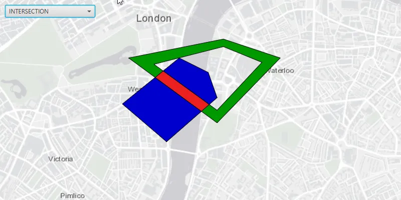
Determining the spatial relationships between points, lines or polygons is a fundamental concept in GIS. For example, a data analyst may need to find the intersection between areas with a high concentration of medical emergency situations and the service area of a hospital.
How to use the sample
The sample provides a drop down on the top, where you can select a geometry operation. When you choose a geometry operation, the application performs this operation between the overlapping polygons and applies the result to the geometries.
How it works
- Get the
Geometryof the features you would like to perform a spatial operation on. - Use the various static methods of
GeometryEngineto determine the spatial relationships between the geometries. For example, useGeometryEngine.intersection(polygon1.getGeometry(), polygon2.getGeometry())to find the intersection between two polygons.
Relevant API
- Geometry
- Graphic
- GraphicsOverlay
- MapView
- Point
- PointCollection
- SimpleLineSymbol
- SimpleFillSymbol
Tags
combine, difference, edit, intersect, intersection, modify, symmetric difference, union
Sample code
SpatialOperationsSample.java
/* * Copyright 2017 Esri. * * Licensed under the Apache License, Version 2.0 (the "License"); you may not * use this file except in compliance with the License. You may obtain a copy of * the License at * * http://www.apache.org/licenses/LICENSE-2.0 * * Unless required by applicable law or agreed to in writing, software * distributed under the License is distributed on an "AS IS" BASIS, WITHOUT * WARRANTIES OR CONDITIONS OF ANY KIND, either express or implied. See the * License for the specific language governing permissions and limitations under * the License. */
package com.esri.samples.spatial_operations;
import javafx.application.Application;import javafx.collections.FXCollections;import javafx.geometry.Insets;import javafx.geometry.Pos;import javafx.scene.Scene;import javafx.scene.control.Alert;import javafx.scene.control.ComboBox;import javafx.scene.layout.StackPane;import javafx.scene.paint.Color;import javafx.stage.Stage;
import com.esri.arcgisruntime.ArcGISRuntimeEnvironment;import com.esri.arcgisruntime.geometry.Geometry;import com.esri.arcgisruntime.geometry.GeometryEngine;import com.esri.arcgisruntime.geometry.Part;import com.esri.arcgisruntime.geometry.PartCollection;import com.esri.arcgisruntime.geometry.Point;import com.esri.arcgisruntime.geometry.PointCollection;import com.esri.arcgisruntime.geometry.Polygon;import com.esri.arcgisruntime.geometry.SpatialReferences;import com.esri.arcgisruntime.loadable.LoadStatus;import com.esri.arcgisruntime.mapping.ArcGISMap;import com.esri.arcgisruntime.mapping.BasemapStyle;import com.esri.arcgisruntime.mapping.view.Graphic;import com.esri.arcgisruntime.mapping.view.GraphicsOverlay;import com.esri.arcgisruntime.mapping.view.MapView;import com.esri.arcgisruntime.symbology.SimpleFillSymbol;import com.esri.arcgisruntime.symbology.SimpleLineSymbol;
public class SpatialOperationsSample extends Application {
  private ArcGISMap map; // keep loadable in scope to avoid garbage collection  private MapView mapView;  private GraphicsOverlay resultGeomOverlay;  private Graphic polygon1;  private Graphic polygon2;
  // geometry operations  private enum OPERATION_TYPE {    NONE, UNION, DIFFERENCE, SYMMETRIC_DIFFERENCE, INTERSECTION  }
  // simple black line symbol  private final SimpleLineSymbol line = new SimpleLineSymbol(SimpleLineSymbol.Style.SOLID, Color.BLACK, 1);
  @Override  public void start(Stage stage) {
    try {      // create stack pane and application scene      StackPane stackPane = new StackPane();      Scene scene = new Scene(stackPane);      scene.getStylesheets().add(getClass().getResource("/spatial_operations/style.css").toExternalForm());
      // set title, size, and add scene to stage      stage.setTitle("Spatial Operations Sample");      stage.setWidth(800);      stage.setHeight(700);      stage.setScene(scene);      stage.show();
      // authentication with an API key or named user is required to access basemaps and other location services      String yourAPIKey = System.getProperty("apiKey");      ArcGISRuntimeEnvironment.setApiKey(yourAPIKey);
      // initialise comboBox items      ComboBox<OPERATION_TYPE> geomOperationBox = new ComboBox<>(FXCollections.observableArrayList(OPERATION_TYPE          .values()));      geomOperationBox.getSelectionModel().select(OPERATION_TYPE.NONE);      geomOperationBox.setMaxWidth(180);      geomOperationBox.setDisable(true);
      // handle ComboBox event to perform the selected geometry operation      geomOperationBox.setOnAction(e -> {        resultGeomOverlay.getGraphics().clear();        Geometry resultPolygon;        switch (geomOperationBox.getSelectionModel().getSelectedItem()) {          case UNION:            resultPolygon = GeometryEngine.union(polygon1.getGeometry(), polygon2.getGeometry());            break;          case DIFFERENCE:            resultPolygon = GeometryEngine.difference(polygon1.getGeometry(), polygon2.getGeometry());            break;          case SYMMETRIC_DIFFERENCE:            resultPolygon = GeometryEngine.symmetricDifference(polygon1.getGeometry(), polygon2.getGeometry());            break;          case INTERSECTION:            resultPolygon = GeometryEngine.intersection(polygon1.getGeometry(), polygon2.getGeometry());            break;          case NONE:          default:            return;        }
        // update result as a red geometry        SimpleFillSymbol redSymbol = new SimpleFillSymbol(SimpleFillSymbol.Style.SOLID, Color.RED, line);        resultGeomOverlay.getGraphics().add(new Graphic(resultPolygon, redSymbol));      });
      // create a map with the light gray basemap style      map = new ArcGISMap(BasemapStyle.ARCGIS_LIGHT_GRAY);
      // enable geometry operations when the map is done loading      map.addDoneLoadingListener(() -> {        if (map.getLoadStatus() == LoadStatus.LOADED) {          geomOperationBox.setDisable(false);        } else {          Alert alert = new Alert(Alert.AlertType.ERROR, "Map Failed to Load!");          alert.show();        }      });
      // create a map view and set the map to it      mapView = new MapView();      mapView.setMap(map);
      // set a viewpoint on the map view centered on London      mapView.setViewpointCenterAsync(new Point(-14153, 6710527, SpatialReferences.getWebMercator()), 30000);
      // create geometry overlays      GraphicsOverlay geomOverlay = new GraphicsOverlay();      mapView.getGraphicsOverlays().add(geomOverlay);
      resultGeomOverlay = new GraphicsOverlay();      mapView.getGraphicsOverlays().add(resultGeomOverlay);
      // create sample polygons      createPolygons();
      geomOverlay.getGraphics().add(polygon1);      geomOverlay.getGraphics().add(polygon2);
      // add the map view and control panel to stack pane      stackPane.getChildren().addAll(mapView, geomOperationBox);      StackPane.setAlignment(geomOperationBox, Pos.TOP_LEFT);      StackPane.setMargin(geomOperationBox, new Insets(10, 0, 0, 10));
    } catch (Exception e) {      // on any error, display the stack trace      e.printStackTrace();    }  }
  /**   * Creates the two intersecting polygons used in the application.   */  private void createPolygons() {
    // create blue polygon    PointCollection pointsPoly = new PointCollection(SpatialReferences.getWebMercator());    pointsPoly.add(new Point(-13960, 6709400));    pointsPoly.add(new Point(-14660, 6710000));    pointsPoly.add(new Point(-13760, 6710730));    pointsPoly.add(new Point(-13300, 6710500));    pointsPoly.add(new Point(-13160, 6710100));
    SimpleFillSymbol fillSymbol = new SimpleFillSymbol(SimpleFillSymbol.Style.SOLID, Color.BLUE, line);    Polygon polygonSymbol = new Polygon(pointsPoly);    polygon1 = new Graphic(polygonSymbol, fillSymbol);
    // create green polygon    // outer ring    PointCollection outerRingSegmentCollection = new PointCollection(SpatialReferences.getWebMercator());    outerRingSegmentCollection.add(new Point(-13060, 6711030));    outerRingSegmentCollection.add(new Point(-12160, 6710730));    outerRingSegmentCollection.add(new Point(-13160, 6709700));    outerRingSegmentCollection.add(new Point(-14560, 6710730));    Part outerRing = new Part(outerRingSegmentCollection);
    // inner ring    PointCollection innerRingSegmentCollection = new PointCollection(SpatialReferences.getWebMercator());    innerRingSegmentCollection.add(new Point(-13060, 6710910));    innerRingSegmentCollection.add(new Point(-14160, 6710630));    innerRingSegmentCollection.add(new Point(-13160, 6709900));    innerRingSegmentCollection.add(new Point(-12450, 6710660));    Part innerRing = new Part(innerRingSegmentCollection);
    PartCollection polygonParts = new PartCollection(outerRing);    polygonParts.add(innerRing);    fillSymbol = new SimpleFillSymbol(SimpleFillSymbol.Style.SOLID, Color.GREEN, line);    polygon2 = new Graphic(new Polygon(polygonParts), fillSymbol);  }
  /**   * Stops and releases all resources used in application.   */  @Override  public void stop() {
    if (mapView != null) {      mapView.dispose();    }  }
  /**   * Opens and runs application.   *   * @param args arguments passed to this application   */  public static void main(String[] args) {
    Application.launch(args);  }}