Get a list of suitable transformations for projecting a geometry between two spatial references with different horizontal datums.
Use case
Transformations (sometimes known as datum or geographic transformations) are used when projecting data from one spatial reference to another when there is a difference in the underlying datum of the spatial references. Transformations can be mathematically defined by specific equations (equation-based transformations), or may rely on external supporting files (grid-based transformations). Choosing the most appropriate transformation for a situation can ensure the best possible accuracy for this operation. Some users familiar with transformations may wish to control which transformation is used in an operation.
How to use the sample
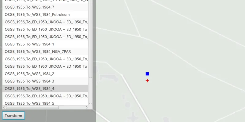
Select a transformation from the list and click ‘Transform’ to see the result of projecting the point from EPSG:27700 to EPSG:3857 using that transformation. The result is shown as a red cross; you can visually compare the original blue point with the projected red cross.
Select ‘Order by extent suitability’ to limit the transformations that are appropriate for the current extent.
If the selected transformation is not usable (has missing grid files) then an error is displayed.
How it works
- Pass the input and output spatial references to
TransformationCatalog.getTransformationsBySuitability()for transformations based on the map’s spatial reference OR additionally provide an extent argument to only return transformations suitable to the extent. This returns a list of ranked transformations. - Use one of the
DatumTransformationobjects returned to project the input geometry to the output spatial reference.
Relevant API
- DatumTransformation
- GeometryEngine
- TransformationCatalog
About the data
The map starts out zoomed into the grounds of the Royal Observatory, Greenwich. The initial point is in the British National Grid spatial reference, which was created by the United Kingdom Ordnance Survey. The spatial reference after projection is in web mercator.
Additional information
Some transformations aren’t available until transformation data is provided.
DatumTransformation has two subclasses, GeographicTransformation and HorizontalVerticalTransformation. GeographicTransformation is used to transform coordinates of geometries between spatial references that have two different geographic coordinate systems. HorizontalVerticalTransformation is used to transform coordinates of z-aware geometries between spatial references that have different geographic and/or vertical coordinate systems.
This sample can be used with or without provisioning projection engine data to your device. If you do not provision data, a limited number of transformations will be available.
To download projection engine data to your device:
- Log in to the ArcGIS for Developers site using your Developer account.
- In the Dashboard page, click ‘Downloads’ and go to the
Projection Engine Datatab. - Click the download button next to
Projection Engine Datato download projection engine data to your computer. - Unzip the downloaded data on your computer.
- Create a
resources/pedatadirectory on your device if it doesn’t already exist in the ArcGIS Maps SDK for Java install directory, and copy the files to this directory.
Tags
datum, geodesy, projection, spatial reference, transformation
Sample code
/* * Copyright 2018 Esri. * * Licensed under the Apache License, Version 2.0 (the "License"); you may not * use this file except in compliance with the License. You may obtain a copy of * the License at * * http://www.apache.org/licenses/LICENSE-2.0 * * Unless required by applicable law or agreed to in writing, software * distributed under the License is distributed on an "AS IS" BASIS, WITHOUT * WARRANTIES OR CONDITIONS OF ANY KIND, either express or implied. See the * License for the specific language governing permissions and limitations under * the License. */
package com.esri.samples.list_transformations_by_suitability;
import java.util.List;
import javafx.application.Application;import javafx.event.ActionEvent;import javafx.geometry.Insets;import javafx.geometry.Pos;import javafx.scene.Scene;import javafx.scene.control.Alert;import javafx.scene.control.Button;import javafx.scene.control.CheckBox;import javafx.scene.control.ListCell;import javafx.scene.control.ListView;import javafx.scene.layout.Background;import javafx.scene.layout.BackgroundFill;import javafx.scene.layout.CornerRadii;import javafx.scene.layout.StackPane;import javafx.scene.layout.VBox;import javafx.scene.paint.Color;import javafx.scene.paint.Paint;import javafx.stage.Stage;
import com.esri.arcgisruntime.ArcGISRuntimeEnvironment;import com.esri.arcgisruntime.geometry.DatumTransformation;import com.esri.arcgisruntime.geometry.GeometryEngine;import com.esri.arcgisruntime.geometry.Point;import com.esri.arcgisruntime.geometry.SpatialReference;import com.esri.arcgisruntime.geometry.TransformationCatalog;import com.esri.arcgisruntime.mapping.ArcGISMap;import com.esri.arcgisruntime.mapping.BasemapStyle;import com.esri.arcgisruntime.mapping.view.Graphic;import com.esri.arcgisruntime.mapping.view.GraphicsOverlay;import com.esri.arcgisruntime.mapping.view.MapView;import com.esri.arcgisruntime.symbology.SimpleMarkerSymbol;
public class ListTransformationsBySuitabilitySample extends Application {
  private ArcGISMap map; // keep loadable in scope to avoid garbage collection  private MapView mapView;
  @Override  public void start(Stage stage) {
    try {      // create stack pane and application scene      StackPane stackPane = new StackPane();      Scene scene = new Scene(stackPane);      scene.getStylesheets().add(getClass().getResource("/list_transformations_by_suitability/style.css").toExternalForm());
      // set title, size, and add scene to stage      stage.setTitle("List Transformations by Suitability Sample");      stage.setWidth(800);      stage.setHeight(700);      stage.setScene(scene);      stage.show();
      // authentication with an API key or named user is required to access basemaps and other location services      String yourAPIKey = System.getProperty("apiKey");      ArcGISRuntimeEnvironment.setApiKey(yourAPIKey);
      // create a map with the light gray basemap style      map = new ArcGISMap(BasemapStyle.ARCGIS_LIGHT_GRAY);
      // create a map view and set the map to it      mapView = new MapView();      mapView.setMap(map);
      // create a graphics overlay to show the original graphic and the the transformed graphic      GraphicsOverlay graphicsOverlay = new GraphicsOverlay();      mapView.getGraphicsOverlays().add(graphicsOverlay);
      // create a blue square graphic located in the Greenwich observatory courtyard in London, UK, the location of the      // Greenwich prime meridian. This will be projected using the selected transformation.      Point originalPoint = new Point(538985.355, 177329.516, SpatialReference.create(27700));      Graphic originalGraphic = new Graphic(originalPoint, new SimpleMarkerSymbol(SimpleMarkerSymbol.Style.SQUARE, Color.BLUE,        10));      graphicsOverlay.getGraphics().add(originalGraphic);
      // create red cross graphic for transformed point      Graphic transformedGraphic = new Graphic();      transformedGraphic.setSymbol(new SimpleMarkerSymbol(SimpleMarkerSymbol.Style.CROSS, Color.RED, 10));      transformedGraphic.setVisible(false);      graphicsOverlay.getGraphics().add(transformedGraphic);
      // zoom to the location of the original graphic      mapView.setViewpointCenterAsync(originalPoint, 5000);
      // create a list of transformations      ListView<DatumTransformation> transformationsListView = new ListView<>();
      // show the transformation name in the list      transformationsListView.setCellFactory(list -> new ListCell<DatumTransformation>() {
        @Override        protected void updateItem(DatumTransformation transformation, boolean isEmpty) {
          super.updateItem(transformation, isEmpty);          if (isEmpty) {            setText(null);          }          else if (transformation != null) {            setText(transformation.getName());          }        }
      });
      // if the checkbox is not selected, transformations should be ordered by suitability for the whole      // spatial reference. If checked, then transformations will be ordered by suitability for the map extent.      CheckBox suitabilityCheckBox = new CheckBox("Order by extent suitability");      suitabilityCheckBox.setOnAction(e -> {        transformationsListView.getItems().clear();        List<DatumTransformation> transformations;        if (suitabilityCheckBox.isSelected()) {          transformations = TransformationCatalog.getTransformationsBySuitability(            originalGraphic.getGeometry().getSpatialReference(), map.getSpatialReference(), mapView.getVisibleArea().getExtent());        } else {          transformations = TransformationCatalog.getTransformationsBySuitability(            originalGraphic.getGeometry().getSpatialReference(), map.getSpatialReference());        }        transformationsListView.getItems().addAll(transformations);      });
      // trigger the event to load the initial transformations list when the map is loaded      map.addDoneLoadingListener(() -> suitabilityCheckBox.fireEvent(new ActionEvent()));
      // create a button that when clicked, shows a new graphic with the selected transformation applied      Button transformButton = new Button("Transform");      transformButton.setOnAction(e -> {        DatumTransformation transformation = transformationsListView.getSelectionModel().getSelectedItem();        if (transformation != null) {          try {            Point projectedPoint = (Point) GeometryEngine.project(originalGraphic.getGeometry(), mapView.getSpatialReference(),              transformation);            transformedGraphic.setVisible(true);            transformedGraphic.setGeometry(projectedPoint);          } catch (Exception ex) {            new Alert(Alert.AlertType.ERROR, ex.getMessage()).show();          }        }      });
      // add the controls to the view      VBox controlsVBox = new VBox(6);      controlsVBox.setBackground(new Background(new BackgroundFill(Paint.valueOf("rgba(0,0,0,0.3)"), CornerRadii.EMPTY,          Insets.EMPTY)));      controlsVBox.setPadding(new Insets(10.0));      controlsVBox.setMaxSize(300, 500);      controlsVBox.getStyleClass().add("panel-region");      controlsVBox.getChildren().addAll(suitabilityCheckBox, transformationsListView, transformButton);
      // add the map view to stack pane      stackPane.getChildren().addAll(mapView, controlsVBox);      StackPane.setAlignment(controlsVBox, Pos.TOP_LEFT);      StackPane.setMargin(controlsVBox, new Insets(10, 0, 0, 10));    } catch (Exception e) {      // on any error, display the stack trace.      e.printStackTrace();    }  }
  /**   * Stops and releases all resources used in application.   */  @Override  public void stop() {
    if (mapView != null) {      mapView.dispose();    }  }
  /**   * Opens and runs application.   *   * @param args arguments passed to this application   */  public static void main(String[] args) {
    Application.launch(args);  }
}