Get the elevation for a given point on a surface in a scene.
Use case
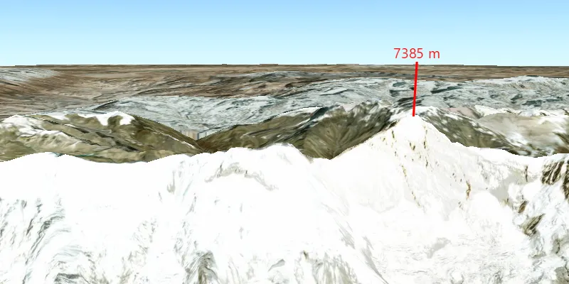
Knowing the elevation at a given point in a landscape can aid in navigation, planning and survey in the field.
How to use the sample
Click anywhere on the surface to get the elevation at that point. Elevation is reported in meters since the scene view is in WGS84.
How it works
- Create a
SceneViewandArcGISScenewith an imagery base map. - Set an
ArcGISTiledElevationSourceas the elevation source of the scene’s base surface. - Use the
screenToBaseSurface(screenPoint)method on the scene view to convert the clicked screen point into a point on surface. - Use the
getElevationAsync(surfacePoint)method on the base surface to asynchronously get the elevation.
Relevant API
- ArcGISTiledElevationSource
- BaseSurface
- ElevationSourcesList
- SceneView
Additional information
getElevationAsync(surfacePoint) retrieves the most accurate available elevation value at a given point. To do this, the method must go to the server or local raster file and load the highest level of detail of data for the target location and return the elevation value.
If multiple elevation sources are present in the surface, the top most visible elevation source with a valid elevation in the given location is used to determine the result.
Tags
elevation, surface
Sample code
/* * Copyright 2019 Esri. * * Licensed under the Apache License, Version 2.0 (the "License"); you may not * use this file except in compliance with the License. You may obtain a copy of * the License at * * http://www.apache.org/licenses/LICENSE-2.0 * * Unless required by applicable law or agreed to in writing, software * distributed under the License is distributed on an "AS IS" BASIS, WITHOUT * WARRANTIES OR CONDITIONS OF ANY KIND, either express or implied. See the * License for the specific language governing permissions and limitations under * the License. */
package com.esri.samples.get_elevation_at_a_point;
import java.util.concurrent.ExecutionException;
import javafx.application.Application;import javafx.geometry.Point2D;import javafx.scene.control.Alert;import javafx.scene.input.MouseButton;import javafx.scene.layout.StackPane;import javafx.scene.Scene;import javafx.scene.paint.Color;import javafx.stage.Stage;
import com.esri.arcgisruntime.ArcGISRuntimeEnvironment;import com.esri.arcgisruntime.concurrent.ListenableFuture;import com.esri.arcgisruntime.geometry.Point;import com.esri.arcgisruntime.geometry.Polyline;import com.esri.arcgisruntime.geometry.PolylineBuilder;import com.esri.arcgisruntime.mapping.ArcGISScene;import com.esri.arcgisruntime.mapping.ArcGISTiledElevationSource;import com.esri.arcgisruntime.mapping.BasemapStyle;import com.esri.arcgisruntime.mapping.Surface;import com.esri.arcgisruntime.mapping.view.Camera;import com.esri.arcgisruntime.mapping.view.Graphic;import com.esri.arcgisruntime.mapping.view.GraphicsOverlay;import com.esri.arcgisruntime.mapping.view.LayerSceneProperties;import com.esri.arcgisruntime.mapping.view.SceneView;import com.esri.arcgisruntime.symbology.TextSymbol;import com.esri.arcgisruntime.symbology.SimpleLineSymbol;
public class GetElevationAtAPointSample extends Application {
  private SceneView sceneView;  private GraphicsOverlay graphicsOverlay;
  @Override  public void start(Stage stage) {
    try {      // create stack pane and application scene      StackPane stackPane = new StackPane();      Scene fxScene = new Scene(stackPane);      fxScene.getStylesheets().add(getClass().getResource("/get_elevation_at_a_point/style.css").toExternalForm());
      // set title, size, and add JavaFX scene to stage      stage.setTitle("Get Elevation at a Point Sample");      stage.setWidth(800);      stage.setHeight(700);      stage.setScene(fxScene);      stage.show();
      // authentication with an API key or named user is required to access basemaps and other location services      String yourAPIKey = System.getProperty("apiKey");      ArcGISRuntimeEnvironment.setApiKey(yourAPIKey);
      // create a scene with a basemap style      ArcGISScene scene = new ArcGISScene(BasemapStyle.ARCGIS_IMAGERY);
      // add the SceneView to the stack pane      sceneView = new SceneView();      sceneView.setArcGISScene(scene);      stackPane.getChildren().add(sceneView);
      // add base surface for elevation data      Surface surface = new Surface();      surface.getElevationSources().add(new ArcGISTiledElevationSource("https://elevation3d.arcgis.com/arcgis/rest/services/WorldElevation3D/Terrain3D/ImageServer"));      scene.setBaseSurface(surface);
      // create a point symbol and graphic to mark where elevation is being measured      SimpleLineSymbol elevationLineSymbol = new SimpleLineSymbol(SimpleLineSymbol.Style.SOLID, Color.RED, 3.0f);      Graphic polylineGraphic = new Graphic();      polylineGraphic.setSymbol(elevationLineSymbol);
      // create a text symbol and graphic to display the elevation of selected points      TextSymbol elevationTextSymbol = new TextSymbol(20, null, Color.RED, TextSymbol.HorizontalAlignment.CENTER, TextSymbol.VerticalAlignment.BOTTOM);      Graphic elevationTextGraphic = new Graphic();      elevationTextGraphic.setSymbol(elevationTextSymbol);
      // create a graphics overlay      graphicsOverlay = new GraphicsOverlay(GraphicsOverlay.RenderingMode.DYNAMIC);      graphicsOverlay.getSceneProperties().setSurfacePlacement(LayerSceneProperties.SurfacePlacement.RELATIVE);      sceneView.getGraphicsOverlays().add(graphicsOverlay);
      // add a camera and initial camera position      Camera camera = new Camera(28.42, 83.9, 10000.0, 10.0, 80.0, 0.0);      sceneView.setViewpointCamera(camera);
      // create listener to handle clicks      sceneView.setOnMouseClicked(event -> {        if (event.getButton() == MouseButton.PRIMARY && event.isStillSincePress()) {          // get the clicked screenPoint          Point2D screenPoint = new Point2D(event.getX(), event.getY());          // convert the screen point to a point on the surface          Point relativeSurfacePoint = sceneView.screenToBaseSurface(screenPoint);
          // check that the point is on the surface          if (relativeSurfacePoint != null) {
            // clear any existing graphics from the graphics overlay            graphicsOverlay.getGraphics().clear();
            // construct a polyline to use as a marker            PolylineBuilder polylineBuilder = new PolylineBuilder(relativeSurfacePoint.getSpatialReference());            Point baseOfPolyline = new Point(relativeSurfacePoint.getX(), relativeSurfacePoint.getY(), 0);            polylineBuilder.addPoint(baseOfPolyline);            Point topOfPolyline = new Point(baseOfPolyline.getX(), baseOfPolyline.getY(), 750);            polylineBuilder.addPoint(topOfPolyline);            Polyline markerPolyline = polylineBuilder.toGeometry();            polylineGraphic.setGeometry(markerPolyline);            graphicsOverlay.getGraphics().add(polylineGraphic);
            // get the surface elevation at the surface point            ListenableFuture<Double> elevationFuture = scene.getBaseSurface().getElevationAsync(relativeSurfacePoint);            elevationFuture.addDoneListener(() -> {              try {                // get the surface elevation                Double elevation = elevationFuture.get();
                // update the text in the elevation marker                elevationTextSymbol.setText(Math.round(elevation) + " m");                elevationTextGraphic.setGeometry(topOfPolyline);                graphicsOverlay.getGraphics().add(elevationTextGraphic);
              } catch (InterruptedException | ExecutionException e) {                new Alert(Alert.AlertType.ERROR, e.getCause().getMessage()).show();              }            });          }        }      });    } catch (Exception e) {      // on any error, display the stack trace.      e.printStackTrace();    }  }
  /**   * Stops and releases all resources used in application.   */  @Override  public void stop() {
    if (sceneView != null) {      sceneView.dispose();    }  }
  /**   * Opens and runs application.   *   * @param args arguments passed to this application   */  public static void main(String[] args) {
    Application.launch(args);  }
}