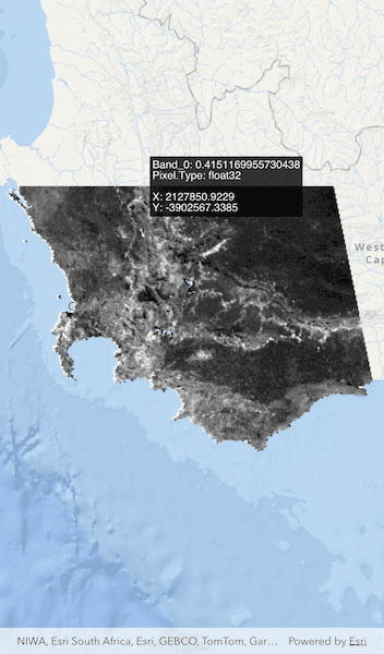
Get the cell value of a local raster at the tapped location and display the result in the UI.
Use case
You may want to identify a raster layer to get its exact cell value in the case the approximate value conveyed by its symbology is not sufficient. The information available for the raster cell depends on the type of raster layer being identified. For example, a 3-band satellite or aerial image might provide 8-bit RGB values, whereas a digital elevation model (DEM) would provide floating point z values. By identifying a raster cell of a DEM, you can retrieve the precise elevation of a location.
How to use the sample
Tap an area of the raster to identify it and see the raw raster cell information displayed in the UI.
How it works
- Get the screen point on the map where a user tapped or long pressed and dragged from the
ArcGISMapView. - On tap:
- Call
ArcGISMapViewController.identifyLayer(...)passing in the screen point, tolerance, and maximum number of results per layer. - Await the result of the identify and then get the
GeoElementfrom the layer result. - Create a
SimpleRendererat the calculated map point and populate the content with text from theGeoElement.attributes.
Relevant API
- ArcGISMapViewController.identifyLayer
- GeoElement
- GeoElement.attributes
- Raster
- RasterLayer
About the data
The data shown is an NDVI classification derived from MODIS imagery between 27 Apr 2020 and 4 May 2020. It comes from the NASA Worldview application. In a normalized difference vegetation index, or NDVI, values range between -1 and +1 with the positive end of the spectrum showing green vegetation.
Tags
band, cell, cell value, continuous, discrete, identify, NDVI, pixel, pixel value, raster
Sample Code
// Copyright 2025 Esri
//
// Licensed under the Apache License, Version 2.0 (the "License");
// you may not use this file except in compliance with the License.
// You may obtain a copy of the License at
//
// https://www.apache.org/licenses/LICENSE-2.0
//
// Unless required by applicable law or agreed to in writing, software
// distributed under the License is distributed on an "AS IS" BASIS,
// WITHOUT WARRANTIES OR CONDITIONS OF ANY KIND, either express or implied.
// See the License for the specific language governing permissions and
// limitations under the License.
//
import 'dart:io';
import 'package:arcgis_maps/arcgis_maps.dart';
import 'package:arcgis_maps_sdk_flutter_samples/common/common.dart';
import 'package:flutter/material.dart';
import 'package:path_provider/path_provider.dart';
class IdentifyRasterCell extends StatefulWidget {
const IdentifyRasterCell({super.key});
@override
State<IdentifyRasterCell> createState() => _IdentifyRasterCellState();
}
class _IdentifyRasterCellState extends State<IdentifyRasterCell>
with SampleStateSupport {
// Create a controller for the map view.
final _mapViewController = ArcGISMapView.createController();
// A flag for when the map view is ready and controls can be used.
var _ready = false;
// Raster layer to display raster data on the map.
late RasterLayer _rasterLayer;
// Graphic to get the raster cell information.
final Graphic _textGraphic = Graphic();
// Graphics overlay to display the text graphic.
final _textGraphicsOverlay = GraphicsOverlay();
@override
Widget build(BuildContext context) {
return Scaffold(
body: Stack(
children: [
ArcGISMapView(
controllerProvider: () => _mapViewController,
onMapViewReady: onMapViewReady,
onTap: onTap,
),
LoadingIndicator(visible: !_ready),
],
),
);
}
Future<void> onMapViewReady() async {
// Create a map with the oceans basemap style.
final map = ArcGISMap.withBasemapStyle(BasemapStyle.arcGISOceans);
// Add map to the map view.
_mapViewController.arcGISMap = map;
// Load the raster layer.
await loadRasterLayer();
// Add the Raster Layer to the map.
map.operationalLayers.add(_rasterLayer);
// Set the viewpoint.
if (_rasterLayer.fullExtent != null) {
await _mapViewController.setViewpointGeometry(_rasterLayer.fullExtent!);
}
// Add the text graphic to the text graphics overlay.
_textGraphicsOverlay.graphics.add(_textGraphic);
// Add the text graphics overlay to the map view.
_mapViewController.graphicsOverlays.add(_textGraphicsOverlay);
// Set the ready state variable to true to enable the sample UI.
setState(() => _ready = true);
}
Future<void> onTap(Offset position) async {
// Get the result for where the user tapped on the raster layer.
final identifyResult = await _mapViewController.identifyLayer(
_rasterLayer,
screenPoint: position,
tolerance: 1,
);
// Get the identified raster cell.
if (identifyResult.geoElements.isNotEmpty) {
// Create a StringBuffer to display information to the user.
final stringBuffer = StringBuffer();
final cell = identifyResult.geoElements.first;
// Loop through the attributes (key/value pairs).
cell.attributes.forEach((key, value) {
stringBuffer.writeln('$key: $value');
});
// Get the x and y values of the cell.
if (cell.geometry != null) {
final x = cell.geometry!.extent.xMin;
final y = cell.geometry!.extent.yMin;
// Add the x & y coordinates where the user clicked raster cell to the string buffer.
stringBuffer.writeln();
stringBuffer.writeln('X: ${x.toStringAsFixed(4)}');
stringBuffer.write('Y: ${y.toStringAsFixed(4)}');
final textSymbol = TextSymbol(
color: Colors.white,
size: 12,
text: stringBuffer.toString(),
horizontalAlignment: HorizontalAlignment.left,
);
textSymbol.backgroundColor = Colors.black.withValues(alpha: 0.8);
_textGraphic.geometry = cell.geometry;
_textGraphicsOverlay.renderer = SimpleRenderer(symbol: textSymbol);
}
} else {
_textGraphicsOverlay.renderer = null;
}
}
Future<void> loadRasterLayer() async {
// Get the application documents directory.
final appDir = await getApplicationDocumentsDirectory();
const downloadFileName = 'SA_EVI_8Day_03May20';
final zipFile = File('${appDir.absolute.path}/$downloadFileName.zip');
// Download the raster file if it does not exist.
if (!zipFile.existsSync()) {
await downloadSampleDataWithProgress(
itemIds: ['b5f977c78ec74b3a8857ca86d1d9b318'],
destinationFiles: [zipFile],
);
}
// Create a Raster from the local tif file.
final raster = Raster.withFileUri(
Uri.file(
'${appDir.absolute.path}/$downloadFileName/$downloadFileName.tif',
),
);
// Create a Raster Layer.
_rasterLayer = RasterLayer.withRaster(raster);
// Load the Raster Layer.
await _rasterLayer.load();
}
}