Analyze the exploratory viewshed for an object (GeoElement) in a scene.
Use case
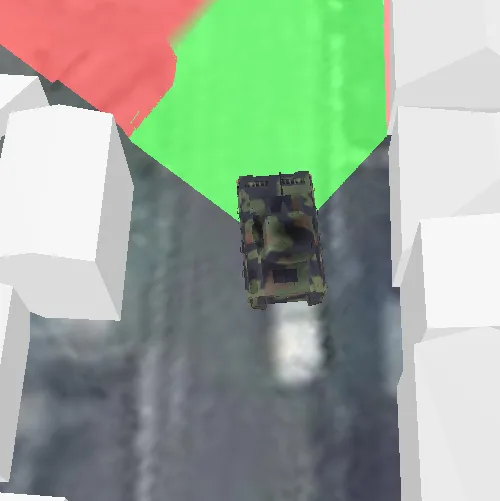
An exploratory viewshed analysis is a type of visual analysis you can perform at the current rendered resolution of a scene. The exploratory viewshed aims to answer the question ‘What can I see from a given location?’. The output is an overlay with two different colors - one representing the visible areas (green) and the other representing the obstructed areas (red).
Note: This analysis is a form of “exploratory analysis”, which means the results are calculated on the current scale of the data, and the results are generated very quickly but not persisted. If persisted analysis performed at the full resolution of the data is required, consider using a ViewshedFunction to perform a viewshed calculation instead.
How to use the sample
Tap to set a destination for the vehicle (a GeoElement). The vehicle will ‘drive’ towards the tapped location. The exploratory viewshed analysis will update as the vehicle moves.
How it works
- Create and show the scene, with an elevation source and a buildings layer.
- Add a model (the
GeoElement) to represent the observer (in this case, a tank).- Use a
SimpleRendererwhich has a heading expression set in theGraphicsOverlay. This way you can relate the viewshed’s heading to theGeoElementobject’s heading.
- Use a
- Create an
ExploratoryGeoElementViewshedwith configuration for the viewshed analysis. - Add the viewshed to an
AnalysisOverlayand add the overlay to the scene. - Configure the SceneView
CameraControllerto orbit the vehicle.
Relevant API
- AnalysisOverlay
- ExploratoryGeoElementViewshed
- GeodeticDistanceResult
- GeometryEngine::distanceGeodetic (used to animate the vehicle)
- ModelSceneSymbol
- OrbitGeoElementCameraController
Offline data
Offline sample data will be downloaded by the sample viewer automatically.
| Link | Local Location |
|---|---|
| Model Marker Symbol Data | <userhome>/ArcGIS/Runtime/Data/3D/bradley_low_3ds/bradle.3ds |
About the data
This sample shows a Buildings in Brest, France Scene from ArcGIS Online. The sample uses a Tank model scene symbol hosted as an item on ArcGIS Online.
Tags
3D, analysis, buildings, exploratory viewshed, model, scene, visibility analysis
Sample code
// [WriteFile Name=ShowExploratoryViewshedFromGeoElementInScene, Category=Analysis]// [Legal]// Copyright 2017 Esri.//// Licensed under the Apache License, Version 2.0 (the "License");// you may not use this file except in compliance with the License.// You may obtain a copy of the License at// http://www.apache.org/licenses/LICENSE-2.0//// Unless required by applicable law or agreed to in writing, software// distributed under the License is distributed on an "AS IS" BASIS,// WITHOUT WARRANTIES OR CONDITIONS OF ANY KIND, either express or implied.// See the License for the specific language governing permissions and// limitations under the License.// [Legal]
#ifdef PCH_BUILD#include "pch.hpp"#endif // PCH_BUILD
// sample headers#include "ShowExploratoryViewshedFromGeoElementInScene.h"
// ArcGIS Maps SDK headers#include "AnalysisListModel.h"#include "AnalysisOverlay.h"#include "AnalysisOverlayListModel.h"#include "AngularUnit.h"#include "ArcGISSceneLayer.h"#include "ArcGISTiledElevationSource.h"#include "AttributeListModel.h"#include "ElevationSourceListModel.h"#include "ExploratoryGeoElementViewshed.h"#include "GeodeticDistanceResult.h"#include "GeometryEngine.h"#include "Graphic.h"#include "GraphicListModel.h"#include "GraphicsOverlay.h"#include "GraphicsOverlayListModel.h"#include "LayerListModel.h"#include "LayerSceneProperties.h"#include "LinearUnit.h"#include "MapTypes.h"#include "ModelSceneSymbol.h"#include "OrbitGeoElementCameraController.h"#include "Point.h"#include "RendererSceneProperties.h"#include "Scene.h"#include "SceneQuickView.h"#include "SceneViewTypes.h"#include "SimpleRenderer.h"#include "SpatialReference.h"#include "Surface.h"#include "SymbolTypes.h"
// Qt headers#include <QList>#include <QStandardPaths>#include <QString>#include <QTimer>#include <QUrl>#include <QVariant>#include <QtCore/qglobal.h>
using namespace Esri::ArcGISRuntime;
// helper method to get cross platform data pathnamespace{  QString defaultDataPath()  {    QString dataPath;
#ifdef Q_OS_IOS    dataPath = QStandardPaths::writableLocation(QStandardPaths::DocumentsLocation);#else    dataPath = QStandardPaths::writableLocation(QStandardPaths::HomeLocation);#endif
    return dataPath;  }} // namespace
ShowExploratoryViewshedFromGeoElementInScene::ShowExploratoryViewshedFromGeoElementInScene(QQuickItem* parent /* = nullptr */) :  QQuickItem(parent){}
void ShowExploratoryViewshedFromGeoElementInScene::init(){  // Register classes for QML  qmlRegisterType<SceneQuickView>("Esri.Samples", 1, 0, "SceneView");  qmlRegisterType<ShowExploratoryViewshedFromGeoElementInScene>("Esri.Samples", 1, 0, "ShowExploratoryViewshedFromGeoElementInSceneSample");}
void ShowExploratoryViewshedFromGeoElementInScene::componentComplete(){  QQuickItem::componentComplete();
  // Create a scene and give it to the SceneView  m_sceneView = findChild<SceneQuickView*>("sceneView");  Scene* scene = new Scene(BasemapStyle::ArcGISImageryStandard, this);
  // Create a surface  Surface* surface = new Surface(this);  surface->elevationSources()->append(    new ArcGISTiledElevationSource(QUrl("https://elevation3d.arcgis.com/arcgis/rest/services/WorldElevation3D/Terrain3D/ImageServer"), this));  scene->setBaseSurface(surface);
  // Add a SceneLayer  ArcGISSceneLayer* sceneLayer =    new ArcGISSceneLayer(QUrl("https://tiles.arcgis.com/tiles/P3ePLMYs2RVChkJx/arcgis/rest/services/Buildings_Brest/SceneServer/layers/0"), this);  scene->operationalLayers()->append(sceneLayer);
  // Add an AnalysisOverlay  m_analysisOverlay = new AnalysisOverlay(this);  m_sceneView->analysisOverlays()->append(m_analysisOverlay);
  // Add a GraphicsOverlay  createGraphicsOverlay();
  // Create a Graphic  createGraphic();
  // Create the GeoElementViewshed  const double horizontalAngle = 90.0;  const double verticalAngle = 25.0;  const double minDistance = 5.0;  const double maxDistance = 250.0;  const double headingOffset = 0.0;  const double pitchOffset = 0.0;  m_viewshed = new ExploratoryGeoElementViewshed(m_tank, horizontalAngle, verticalAngle, minDistance, maxDistance, headingOffset, pitchOffset, this);  m_viewshed->setOffsetY(0.5);  m_viewshed->setOffsetZ(0.5);  m_analysisOverlay->analyses()->append(m_viewshed);
  // Add the Scene to the SceneView  m_sceneView->setArcGISScene(scene);
  // create the camera controller to follow the graphic  OrbitGeoElementCameraController* followingController = new OrbitGeoElementCameraController(m_tank, 200.0, this);  followingController->setCameraPitchOffset(45.0);  m_sceneView->setCameraController(followingController);
  // Create a Timer  m_timer = new QTimer(this);  m_timer->setInterval(100);  connect(m_timer, &QTimer::timeout, this, &ShowExploratoryViewshedFromGeoElementInScene::animate);
  // connect to the mouse clicked signal  connect(m_sceneView, &SceneQuickView::mouseClicked, this, [this](QMouseEvent& event)  {    m_waypoint = m_sceneView->screenToBaseSurface(event.position().x(), event.position().y());    m_timer->start();  });}
void ShowExploratoryViewshedFromGeoElementInScene::createGraphicsOverlay(){  // Add a GraphicsOverlay  m_graphicsOverlay = new GraphicsOverlay(this);  m_sceneView->graphicsOverlays()->append(m_graphicsOverlay);
  // Set the SurfacePlacement  LayerSceneProperties sceneProperties = m_graphicsOverlay->sceneProperties();  sceneProperties.setSurfacePlacement(SurfacePlacement::Relative);  m_graphicsOverlay->setSceneProperties(sceneProperties);
  // Set a Renderer  SimpleRenderer* simpleRenderer = new SimpleRenderer(this);  const QString headingExpression = QString("[%1]").arg(m_headingAttr);  simpleRenderer->setSceneProperties(RendererSceneProperties(headingExpression, "", ""));  m_graphicsOverlay->setRenderer(simpleRenderer);}
void ShowExploratoryViewshedFromGeoElementInScene::createGraphic(){  // Create the Graphic Point  const double x = -4.508708007847015;  const double y = 48.38823243446344;  const double z = 0;  const Point tankPoint(x, y, z, SpatialReference(4326));  const float scale = 10;
  // Create the Graphic Symbol  ModelSceneSymbol* sceneSymbol = new ModelSceneSymbol(QUrl(defaultDataPath() + "/ArcGIS/Runtime/Data/3D/bradley_low_3ds/bradle.3ds"), scale, this);  sceneSymbol->setAnchorPosition(SceneSymbolAnchorPosition::Bottom);  sceneSymbol->setHeading(90.0f);
  // Create the Graphic  QVariantMap attr;  attr[m_headingAttr] = 150.0;  m_tank = new Graphic(tankPoint, attr, sceneSymbol, this);  m_graphicsOverlay->graphics()->append(m_tank);}
void ShowExploratoryViewshedFromGeoElementInScene::animate(){  if (m_waypoint.isEmpty())  {    return;  }
  // get current location and distance from waypoint  Point location = geometry_cast<Point>(m_tank->geometry());  const GeodeticDistanceResult distance =    GeometryEngine::distanceGeodetic(location, m_waypoint, LinearUnit(m_linearUnit), AngularUnit(m_angularUnit), m_curveType);
  // move toward waypoint based on speed and update orientation  location =    GeometryEngine::moveGeodetic(QList<Point>{location}, 1.0, LinearUnit(m_linearUnit), distance.azimuth1(), AngularUnit(m_angularUnit), m_curveType)      .at(0);  m_tank->setGeometry(location);
  // update the heading  const double heading = m_tank->attributes()->attributeValue(m_headingAttr).toDouble();  const QString newHeading = QString::number(heading + (distance.azimuth1() - heading) / 10);  m_tank->attributes()->replaceAttribute(m_headingAttr, newHeading);
  // reached waypoint  if (distance.distance() <= 5)  {    m_waypoint = Point();    m_timer->stop();  }}
// [WriteFile Name=ShowExploratoryViewshedFromGeoElementInScene, Category=Analysis]// [Legal]// Copyright 2017 Esri.//// Licensed under the Apache License, Version 2.0 (the "License");// you may not use this file except in compliance with the License.// You may obtain a copy of the License at// http://www.apache.org/licenses/LICENSE-2.0//// Unless required by applicable law or agreed to in writing, software// distributed under the License is distributed on an "AS IS" BASIS,// WITHOUT WARRANTIES OR CONDITIONS OF ANY KIND, either express or implied.// See the License for the specific language governing permissions and// limitations under the License.// [Legal]
#ifndef ShowExploratoryViewshedFromGeoElementInScene_H#define ShowExploratoryViewshedFromGeoElementInScene_H
// ArcGIS Maps SDK headers#include "GeometryTypes.h"#include "Point.h"
// Qt headers#include <QQuickItem>#include <QTimer>
namespace Esri::ArcGISRuntime{ class SceneQuickView; class AnalysisOverlay; class ExploratoryGeoElementViewshed; class GraphicsOverlay; class Graphic;} // namespace Esri::ArcGISRuntime
class ShowExploratoryViewshedFromGeoElementInScene : public QQuickItem{ Q_OBJECT
public: explicit ShowExploratoryViewshedFromGeoElementInScene(QQuickItem* parent = nullptr); ~ShowExploratoryViewshedFromGeoElementInScene() override = default;
void componentComplete() override; static void init();
private slots: void animate();
private: void createGraphicsOverlay(); void createGraphic();
Esri::ArcGISRuntime::SceneQuickView* m_sceneView = nullptr; Esri::ArcGISRuntime::AnalysisOverlay* m_analysisOverlay = nullptr; Esri::ArcGISRuntime::ExploratoryGeoElementViewshed* m_viewshed = nullptr; Esri::ArcGISRuntime::GraphicsOverlay* m_graphicsOverlay = nullptr; Esri::ArcGISRuntime::Graphic* m_tank = nullptr; Esri::ArcGISRuntime::Point m_waypoint; Esri::ArcGISRuntime::LinearUnitId m_linearUnit = Esri::ArcGISRuntime::LinearUnitId::Meters; Esri::ArcGISRuntime::AngularUnitId m_angularUnit = Esri::ArcGISRuntime::AngularUnitId::Degrees; Esri::ArcGISRuntime::GeodeticCurveType m_curveType = Esri::ArcGISRuntime::GeodeticCurveType::Geodesic;
const QString m_headingAttr = QStringLiteral("HEADING"); QTimer* m_timer = nullptr;};
#endif // ShowExploratoryViewshedFromGeoElementInScene_H// [WriteFile Name=ShowExploratoryViewshedFromGeoElementInScene, Category=Analysis]// [Legal]// Copyright 2017 Esri.//// Licensed under the Apache License, Version 2.0 (the "License");// you may not use this file except in compliance with the License.// You may obtain a copy of the License at// http://www.apache.org/licenses/LICENSE-2.0//// Unless required by applicable law or agreed to in writing, software// distributed under the License is distributed on an "AS IS" BASIS,// WITHOUT WARRANTIES OR CONDITIONS OF ANY KIND, either express or implied.// See the License for the specific language governing permissions and// limitations under the License.// [Legal]
import QtQuickimport Esri.Samples
ShowExploratoryViewshedFromGeoElementInSceneSample { id: rootRectangle clip: true width: 800 height: 600
SceneView { objectName: "sceneView" anchors.fill: parent
Component.onCompleted: { // Set the focus on SceneView to initially enable keyboard navigation forceActiveFocus(); } }}