Create a notification every time a given location data source has entered and/or exited a set of features or graphics.
Use case
Geotriggers can be used to notify users when they have entered or exited a geofence by monitoring a given set of features or graphics. They could be used to display contextual information to museum visitors about nearby exhibits, notify hikers when they have wandered off their desired trail, notify dispatchers when service workers arrive at a scene, or more.
How to use the sample
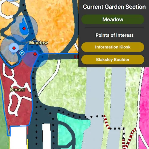
Observe a virtual walking tour of the Santa Barbara Botanic Garden. Information about the user’s current Garden Section, as well as information about nearby points of interest within 10 meters will display or be removed from the UI when the user enters or exits the buffer of each feature.
How it works
- Create a
GeotriggerFeedwith aLocationDataSourceclass (in this case, aSimulatedLocationDataSource). - Create a
FeatureFenceParameterswith aServiceFeatureTableand a buffer distance at which to monitor each feature. - Create a
FenceGeotriggerwith the geotrigger feed, aFenceRuleType, the fence parameters, an Arcade Expression, and a name for the specific geotrigger. - Create a
GeotriggerMonitorwith the fence geotrigger and callGeotriggerMonitor::startAsync()to begin listening for events that meet theFenceRuleType. - When a
GeotriggerMonitor::geotriggerNotificationemits, capture theGeotriggerNotificationInfo. - For more information about the feature that triggered the notification, cast the
GeotriggerNotificationInfoto aFenceGeotriggerNotificationInfoand callFenceGeotriggerNotificationInfo::fenceGeoElement(). - Depending on the
FenceGeotriggerNotificationInfo::fenceNotificationType()display or hide information on the UI from theGeoElement’s attributes.
Relevant API
- ArcadeExpression
- FeatureFenceParameters
- FenceGeotrigger
- FenceGeotriggerNotificationInfo
- FenceRuleType
- GeoElement
- Geotrigger
- GeotriggerFeed
- GeotriggerMonitor
- GeotriggerNotificationInfo
- ServiceFeatureTable
- SimulatedLocationDataSource
About the data
This sample uses the Santa Barbara Botanic Garden Geotriggers Sample ArcGIS Online Web Map which includes a georeferenced map of the garden as well as select polygon and point features to denote garden sections and points of interest. Description text and attachment images in the feature layers were provided by the Santa Barbara Botanic Garden and more information can be found on the Garden Sections & Displays portion of their website. All assets are used with permission from the Santa Barbara Botanic Garden. For more information, visit the Santa Barbara Botanic Garden website.
Tags
alert, arcade, fence, geofence, geotrigger, location, navigation, notification, notify, routing, trigger
Sample code
// [WriteFile Name=Geotriggers, Category=Analysis]// [Legal]// Copyright 2021 Esri.//// Licensed under the Apache License, Version 2.0 (the "License");// you may not use this file except in compliance with the License.// You may obtain a copy of the License at// http://www.apache.org/licenses/LICENSE-2.0//// Unless required by applicable law or agreed to in writing, software// distributed under the License is distributed on an "AS IS" BASIS,// WITHOUT WARRANTIES OR CONDITIONS OF ANY KIND, either express or implied.// See the License for the specific language governing permissions and// limitations under the License.// [Legal]
#ifdef PCH_BUILD#include "pch.hpp"#endif // PCH_BUILD
// sample headers#include "Geotriggers.h"
// ArcGIS Maps SDK headers#include "ArcGISFeature.h"#include "ArcadeExpression.h"#include "Attachment.h"#include "AttachmentListModel.h"#include "AttributeListModel.h"#include "FeatureEditResult.h"#include "FeatureFenceParameters.h"#include "FenceGeotrigger.h"#include "FenceGeotriggerNotificationInfo.h"#include "GeotriggerMonitor.h"#include "GeotriggerNotificationInfo.h"#include "GeotriggersTypes.h"#include "LocationDisplay.h"#include "LocationGeotriggerFeed.h"#include "Map.h"#include "MapQuickView.h"#include "MapViewTypes.h"#include "Polyline.h"#include "PortalItem.h"#include "ServiceFeatureTable.h"#include "SimulatedLocationDataSource.h"#include "SimulationParameters.h"
// Qt headers#include <QDateTime>#include <QFuture>#include <QUuid>
using namespace Esri::ArcGISRuntime;
namespace{  const QString walkingTourPolyineJson(    "{\"paths\":[[[-119.709881177746,34.4570041646846],[-119.709875813328,34.4570152227745],[-119.709869107805,34.4570240692453],[-119.709859720074,"    "34.4570351273326],[-119.709853014551,34.4570539260775],[-119.709847650133,34.4570760422426],[-119.709848991238,34.4570926293626],[-119."    "70985569676,34.4571103222869],[-119.709873131119,34.4571202745552],[-119.709889224373,34.4571302268223],[-119.709902635418,34.4571357558591],[-"    "119.709910682045,34.4571600836165],[-119.709910682045,34.4571744591062],[-119.709902635418,34.4571833055602],[-119.709889224373,34."    "4571910462067],[-119.70988251885,34.4571965752394],[-119.70988251885,34.4572032100782],[-119.709889224373,34.4572175855605],[-119.709898612104,"    "34.4572264320099],[-119.709912023149,34.4572341726524],[-119.709901294313,34.4572419132941],[-119.709895929895,34.4572507597409],[-119."    "709897271,34.4572596061868],[-119.709902635418,34.4572728758539],[-119.709902635418,34.4572828281028],[-119.70990934094,34.457294991961],[-119."    "709912023149,34.4573038384022],[-119.709886542164,34.4573115790375],[-119.709861061178,34.4573248486963],[-119.709843626819,34.4573414357669],[-"    "119.709836921297,34.4573668692686],[-119.709843626819,34.4573934085666],[-119.709827533565,34.4574055724087],[-119.709791323744,34."    "4574188420525],[-119.709749749504,34.4574332174977],[-119.709709516369,34.4574431697275],[-119.709734997354,34.4574807670294],[-119."    "709748062646,34.4575248306656],[-119.709757450378,34.4575635337324],[-119.709770861423,34.457600025179],[-119.709785613572,34.4576387282109],[-"    "119.70980573014,34.4576730080242],[-119.709815117871,34.4577117110223],[-119.709821823394,34.4577504140025],[-119.709821823394,34.4577869053674]"    ",[-119.709821823394,34.4578256083127],[-119.70981780008,34.4578609938471],[-119.709819141185,34.457906331541],[-119.70981460448,34."    "4579890675855],[-119.709818627793,34.4580675790658],[-119.70982667442,34.4581118108532],[-119.709832038838,34.4581471962662],[-119.709834721047,"    "34.4581947453913],[-119.709836062152,34.4582323423548],[-119.709834721047,34.4582787856393],[-119.709805216748,34.4583429215611],[-119."    "709759619195,34.4584026342716],[-119.709700610597,34.4584612411497],[-119.709645400048,34.4585103926263],[-119.709566274882,34.4585457778704],[-"    "119.709493855239,34.4585944325566],[-119.709458986522,34.458622077252],[-119.709424117805,34.4586198656767],[-119.709386566878,34.4586110193749]"    ",[-119.70935438037,34.4586110193749],[-119.709339628221,34.4586231830396],[-119.709324876071,34.4586585682359],[-119.709306100608,34."    "4586862129101],[-119.709269890786,34.4587171749343],[-119.709244409801,34.4587238096523],[-119.709229657651,34.4587293385835],[-119."    "709212223293,34.4587459253751],[-119.70919076562,34.4587945799446],[-119.709174672366,34.4588503400161],[-119.709157238008,34.4589288506865],[-"    "119.709153214694,34.4589951976744],[-119.709155896903,34.4590449578807],[-119.70916394353,34.4590958238387],[-119.709186742307,34.4591323146156]"    ",[-119.709218928815,34.4591621706939],[-119.709237704278,34.4591831805204],[-119.709241727592,34.4592252001575],[-119.709238133851,34."    "459258658624],[-119.709219358388,34.4592796684262],[-119.709207288447,34.4592962551085],[-119.709208629552,34.4593084186733],[-119.709271661463,"    "34.4593791884701],[-119.709310553494,34.4594267368937],[-119.709330670062,34.4594510639836],[-119.709353468838,34.4595008239182],[-119."    "70936285657,34.4595362087426],[-119.709423221989,34.4595943612845],[-119.709455408497,34.4596297460692],[-119.709487595005,34.459665130839],[-"    "119.709507711573,34.4596817174446],[-119.709523804827,34.4596861405389],[-119.709557332439,34.4596894578594],[-119.709586836739,34."    "4596894578594],[-119.709593542261,34.4596772943501],[-119.709590860052,34.4596496500041],[-119.709572084589,34.4595777746615],[-119."    "709566720171,34.4595313320996],[-119.709578790112,34.4595136396883],[-119.709590860052,34.4594992646013],[-119.709627069874,34.4594882068404],[-"    "119.709675349636,34.4595567649343],[-119.709735699339,34.4596197941001],[-119.709775932474,34.4596795058974],[-119.709802754564,34."    "4597126790997],[-119.709832258863,34.4597359003334],[-119.70986712758,34.4597171021923],[-119.70986980979,34.4596839289918],[-119.709865786476,"    "34.4596308518435],[-119.709876515312,34.4595788804365],[-119.70988187973,34.4595346494263],[-119.709879197521,34.4594926299449],[-119."    "709852375431,34.4594539277723],[-119.709806777878,34.4593953215911],[-119.709767885847,34.4593212344729],[-119.709720947189,34.4592195028005],[-"    "119.709708720088,34.4591478732967],[-119.709710061193,34.4591058536206],[-119.709707378984,34.459079314867],[-119.709652393699,34.4590262373344]"    ",[-119.709617524982,34.4589499383221],[-119.709626771268,34.4588695962162],[-119.709683097658,34.4588032491285],[-119.709730036316,34."    "4587391135603],[-119.709759540615,34.4586993052518],[-119.7097850216,34.4586650258598],[-119.710059948024,34.4587744987075],[-119.710104204473,"    "34.4587932970608],[-119.710128443889,34.4587649224307],[-119.71019415801,34.4587096331253],[-119.710273283176,34.4586731421637],[-119."    "71031619852,34.4586532379961],[-119.710367160491,34.4586023717685],[-119.710392641477,34.4585747270665],[-119.710432874612,34.4585083797445],[-"    "119.710471766643,34.4584453497398],[-119.710505294256,34.4584165991955],[-119.710575487456,34.4583689119728],[-119.710705574593,34."    "4583136224052],[-119.710780676446,34.4582627559707],[-119.710839685044,34.4582030431601],[-119.710895995717,34.4581546042213],[-119."    "710948298793,34.458095997128],[-119.710988531928,34.4580263320391],[-119.711015354018,34.4579511379096],[-119.711011330705,34.4579102234284],[-"    "119.710985849719,34.4578847900921],[-119.710946957688,34.4578715205223],[-119.710779319625,34.4578847900921],[-119.71073908649,34.4578847900921]"    ",[-119.7107122644,34.4578604625458],[-119.71069751225,34.4578295002039],[-119.710674713473,34.4578095958352],[-119.710642526965,34."    "4577996436491],[-119.710614363771,34.457830606002],[-119.71057547174,34.4578571451526],[-119.710539261918,34.4578737321174],[-119.71049500547,"    "34.4578858958895],[-119.710452090125,34.4578836842947],[-119.710413198095,34.4578748379149],[-119.710375647168,34.4578527219614],[-119."    "710336755138,34.4578350291944],[-119.710299204211,34.4578107016336],[-119.71027506433,34.4577885856631],[-119.710269605616,34.4577886418169],[-"    "119.710240101317,34.4577510446536],[-119.710198527077,34.4576758502763],[-119.710154270628,34.4575984442288],[-119.710112696389,34."    "4575265671206],[-119.710044300059,34.4574381029023],[-119.709978842634,34.4573543166616],[-119.709966772693,34.4573410470074],[-119."    "709972137111,34.4573200367174],[-119.70997481932,34.4573023438375],[-119.709973478216,34.4572846509538],[-119.709970796007,34.457259217427],[-"    "119.709931903976,34.4572348896984],[-119.709914469617,34.4572337838924],[-119.709893011945,34.4572171968005],[-119.709884965318,34."    "4571972922858],[-119.709902232039,34.4571821133624],[-119.70991161977,34.457167737874],[-119.709907596457,34.4571389868898],[-119.709919666397,"    "34.4571235055865],[-119.709922348606,34.4571047068572],[-119.709918325293,34.4570836965077],[-119.709919666397,34.4570648977695],[-119."    "70992637192,34.4570516280694],[-119.709933077442,34.4570339351326],[-119.709935759651,34.4570151363832],[-119.709927713024,34.4570062899114],[-"    "119.70991161977,34.4570018666751],[-119.709883456576,34.4570040782933]]],\"spatialReference\":{\"wkid\":4326,\"latestWkid\":4326}}");  const QString sectionGeotriggerName = "Section Geotrigger";  const QString poiGeotriggerName = "POI Geotrigger";} // namespace
Geotriggers::Geotriggers(QObject* parent /* = nullptr */) :  QObject(parent){  // This sample uses a web map with a predefined tile basemap, feature styles, and labels  m_map = new Map(new PortalItem("6ab0e91dc39e478cae4f408e1a36a308", this), this);
  // Instantiate the service feature tables to later create GeotriggerMonitors for  m_gardenSections = new ServiceFeatureTable(new PortalItem("1ba816341ea04243832136379b8951d9", this), 0, this);  m_gardenPois = new ServiceFeatureTable(new PortalItem("7c6280c290c34ae8aeb6b5c4ec841167", this), 0, this);}
Geotriggers::~Geotriggers() = default;
void Geotriggers::init(){  // Register the map view for QML  qmlRegisterType<MapQuickView>("Esri.Samples", 1, 0, "MapView");  qmlRegisterType<Geotriggers>("Esri.Samples", 1, 0, "GeotriggersSample");}
// Create READ functions for Q_PROPERTIES like the information about sections and POIsMapQuickView* Geotriggers::mapView() const{  return m_mapView;}
QString Geotriggers::currentSection() const{  if (!m_currentFeaturesEntered[sectionGeotriggerName].isEmpty())  {    return m_currentFeaturesEntered[sectionGeotriggerName].last();  }
  return "N/A";}
QStringList Geotriggers::poisInRange() const{  return m_currentFeaturesEntered[poiGeotriggerName];}
QString Geotriggers::currentDescription() const{  return m_currentFeatureDescription;}
QUrl Geotriggers::currentImageUrl() const{  return m_currentFeatureImageUrl;}
// Set the map view - once that is done we can instantiate the location display and geotrigger monitorsvoid Geotriggers::setMapView(MapQuickView* mapView){  if (!mapView || mapView == m_mapView)  {    return;  }
  m_mapView = mapView;  m_mapView->setMap(m_map);
  emit mapViewChanged();
  // Start the simulated location display data source and create a LocationGeotriggerFeed that will be required in createGeotriggerMonitor()  initializeSimulatedLocationDisplay();
  // Create geotriggers for each of the service feature tables  createGeotriggerMonitor(m_gardenSections, 0.0, sectionGeotriggerName);  createGeotriggerMonitor(m_gardenPois, 10.0, poiGeotriggerName);}
void Geotriggers::initializeSimulatedLocationDisplay(){  m_simulatedLocationDataSource = new SimulatedLocationDataSource(this);
  // Create SimulationParameters starting at the current time, a velocity of 5 m/s, and a horizontal and vertical accuracy of 0.0  SimulationParameters* simulationParameters = new SimulationParameters(QDateTime::currentDateTime(), 5.0, 0.0, 0.0, this);
  // Use the polyline as defined above or from this AGOL GeoJSON to define the path. retrieved from https://https://arcgisruntime.maps.arcgis.com/home/item.html?id=2a346cf1668d4564b8413382ae98a956  m_simulatedLocationDataSource->setLocationsWithPolyline(geometry_cast<Polyline>(Polyline::fromJson(walkingTourPolyineJson)), simulationParameters);
  m_mapView->locationDisplay()->setDataSource(m_simulatedLocationDataSource);  m_mapView->locationDisplay()->setAutoPanMode(LocationDisplayAutoPanMode::Recenter);  m_mapView->locationDisplay()->setInitialZoomScale(1000);  m_mapView->locationDisplay()->start();
  m_simulatedLocationDataSource->start();
  // LocationGeotriggerFeed will be used in instantiating a FenceGeotrigger in createGeotriggerMonitor()  m_geotriggerFeed = new LocationGeotriggerFeed(m_simulatedLocationDataSource, this);}
// This function is used to create two geotrigger monitors in this sample - one for the sections and one for the points of interest// The parameters for this function are the only differences between the two geotrigger monitorsvoid Geotriggers::createGeotriggerMonitor(ServiceFeatureTable* serviceFeatureTable, double bufferSize, const QString& geotriggerName){  FeatureFenceParameters* featureFenceParameters = new FeatureFenceParameters(serviceFeatureTable, bufferSize, this);  // The ArcadeExpression defined in the following FenceGeotrigger returns the value for the "name" field of the feature that triggered the monitor  FenceGeotrigger* fenceGeotrigger = new FenceGeotrigger(m_geotriggerFeed, FenceRuleType::EnterOrExit, featureFenceParameters,                                                         new ArcadeExpression("$fencefeature.name", this), geotriggerName, this);  GeotriggerMonitor* geotriggerMonitor = new GeotriggerMonitor(fenceGeotrigger, this);
  connect(geotriggerMonitor, &GeotriggerMonitor::geotriggerNotification, this, &Geotriggers::handleGeotriggerNotification);
  // startAsync must be explicitly called. It is called after the signal connection is defined to avoid a race condition in Qt.  QFuture<void> future = geotriggerMonitor->startAsync();  Q_UNUSED(future)}
void Geotriggers::handleGeotriggerNotification(GeotriggerNotificationInfo* geotriggerNotificationInfo){  // Create a QScopedPointer so GeotriggerNotificationInfo does not persist outside this scope  QScopedPointer<GeotriggerNotificationInfo> scopedNotification(geotriggerNotificationInfo);
  // GeotriggerNotificationInfo provides access to information about the geotrigger that was triggered  QString geotriggerName = geotriggerNotificationInfo->geotriggerMonitor()->geotrigger()->name();
  // message() returns the evaluated arcade expression defined in the FenceGeotrigger, "$fencefeatue.name" in this case  QString featureName = geotriggerNotificationInfo->message();
  // FenceGeotriggerNotificationInfo provides access to the feature that triggered the notification  FenceGeotriggerNotificationInfo* fenceGeotriggerNotificationInfo = static_cast<FenceGeotriggerNotificationInfo*>(geotriggerNotificationInfo);  GeoElement* fenceGeoElement = fenceGeotriggerNotificationInfo->fenceGeoElement();
  ArcGISFeature* fenceFeature = dynamic_cast<ArcGISFeature*>(fenceGeoElement);
  if (fenceGeotriggerNotificationInfo->fenceNotificationType() == FenceNotificationType::Entered)  {    // If the user enters a given geofence, add the feature's information to the UI and save the feature for querying.    m_currentFeaturesEntered[geotriggerName].append(featureName);
    if (!m_featureQMap.contains(featureName))    {      // Set the parent to the Geotriggers QObject so the feature is still available outside the scope of this function      fenceFeature->setParent(this);      m_featureQMap[featureName] = fenceFeature;    }  }  else  {    // If the user leaves the geofence, remove the information from the UI    m_currentFeaturesEntered[geotriggerName].removeAll(featureName);  }
  emit displayInfoChanged();}
void Geotriggers::getFeatureInformation(const QString& sectionName){  // Recenter the camera on the user if need be  m_mapView->locationDisplay()->setAutoPanMode(LocationDisplayAutoPanMode::Recenter);
  // Clear feature description and image of the previous query  m_currentFeatureImageUrl = QUrl("");
  QMap<QString, ArcGISFeature*>::iterator findIt = m_featureQMap.find(sectionName);
  if (findIt == m_featureQMap.end())  {    m_currentFeatureDescription = "Unable to find information for this Garden feature.";    emit displayInfoChanged();    return;  }
  ArcGISFeature* feature = *findIt;  m_currentFeatureDescription = feature->attributes()->attributeValue("description").toString();
  if (m_featureAttachmentImageUrls.contains(sectionName))  {    m_currentFeatureImageUrl = m_featureAttachmentImageUrls[sectionName];    emit displayInfoChanged();    return;  }
  emit displayInfoChanged();  feature->attachments()->fetchAttachmentsAsync().then(this, [this, sectionName](const QList<Attachment*>& attachments)  {    if (attachments.isEmpty())    {      return;    }
    // Get the first (and only) attachment for the feature    Attachment* sectionImageAttachment = attachments.first();
    sectionImageAttachment->fetchDataAsync().then(this, [this, sectionImageAttachment, sectionName](const QByteArray&)    {      m_featureAttachmentImageUrls[sectionName] = sectionImageAttachment->attachmentUrl();      m_currentFeatureImageUrl = m_featureAttachmentImageUrls[sectionName];      emit displayInfoChanged();    });  });  m_gardenSections->applyEditsAsync(this).then(this, [](QList<FeatureEditResult*> results)  {    qDeleteAll(results);  });}
// [WriteFile Name=Geotriggers, Category=Analysis]// [Legal]// Copyright 2021 Esri.//// Licensed under the Apache License, Version 2.0 (the "License");// you may not use this file except in compliance with the License.// You may obtain a copy of the License at// http://www.apache.org/licenses/LICENSE-2.0//// Unless required by applicable law or agreed to in writing, software// distributed under the License is distributed on an "AS IS" BASIS,// WITHOUT WARRANTIES OR CONDITIONS OF ANY KIND, either express or implied.// See the License for the specific language governing permissions and// limitations under the License.// [Legal]
#ifndef GEOTRIGGERS_H#define GEOTRIGGERS_H
// Qt headers#include <QMap>#include <QObject>#include <QUrl>
namespace Esri::ArcGISRuntime{ class ArcGISFeature; class GeotriggerFeed; class GeotriggerMonitor; class GeotriggerNotificationInfo; class Graphic; class GraphicsOverlay; class Map; class MapQuickView; class Point; class ServiceFeatureTable; class SimulatedLocationDataSource;} // namespace Esri::ArcGISRuntime
Q_MOC_INCLUDE("MapQuickView.h")
class Geotriggers : public QObject{ Q_OBJECT
Q_PROPERTY(Esri::ArcGISRuntime::MapQuickView* mapView READ mapView WRITE setMapView NOTIFY mapViewChanged) Q_PROPERTY(QString currentSection READ currentSection NOTIFY displayInfoChanged) Q_PROPERTY(QStringList poisInRange READ poisInRange NOTIFY displayInfoChanged) Q_PROPERTY(QString currentDescription READ currentDescription NOTIFY displayInfoChanged) Q_PROPERTY(QUrl currentImageUrl READ currentImageUrl NOTIFY displayInfoChanged)
public: explicit Geotriggers(QObject* parent = nullptr); ~Geotriggers();
static void init();
Q_INVOKABLE void getFeatureInformation(const QString& featureName);
signals: void mapViewChanged(); void displayInfoChanged();
private: Esri::ArcGISRuntime::MapQuickView* mapView() const; QString currentSection() const; QStringList poisInRange() const; QString currentDescription() const; QUrl currentImageUrl() const; void setMapView(Esri::ArcGISRuntime::MapQuickView* mapView);
void createGeotriggerMonitor(Esri::ArcGISRuntime::ServiceFeatureTable* serviceFeatureTable, double bufferSize, const QString& geotriggerName); void initializeSimulatedLocationDisplay(); void handleGeotriggerNotification(Esri::ArcGISRuntime::GeotriggerNotificationInfo* geotriggerNotificationInfo);
Esri::ArcGISRuntime::GeotriggerFeed* m_geotriggerFeed = nullptr; Esri::ArcGISRuntime::Map* m_map = nullptr; Esri::ArcGISRuntime::MapQuickView* m_mapView = nullptr; Esri::ArcGISRuntime::ServiceFeatureTable* m_gardenSections = nullptr; Esri::ArcGISRuntime::ServiceFeatureTable* m_gardenPois = nullptr; Esri::ArcGISRuntime::SimulatedLocationDataSource* m_simulatedLocationDataSource = nullptr;
QMap<QString, QStringList> m_currentFeaturesEntered; QString m_currentFeatureDescription; QUrl m_currentFeatureImageUrl; QMap<QString, Esri::ArcGISRuntime::ArcGISFeature*> m_featureQMap; QMap<QString, QUrl> m_featureAttachmentImageUrls;};
#endif // GEOTRIGGERS_H// [WriteFile Name=Geotriggers, Category=Analysis]// [Legal]// Copyright 2021 Esri.//// Licensed under the Apache License, Version 2.0 (the "License");// you may not use this file except in compliance with the License.// You may obtain a copy of the License at// http://www.apache.org/licenses/LICENSE-2.0//// Unless required by applicable law or agreed to in writing, software// distributed under the License is distributed on an "AS IS" BASIS,// WITHOUT WARRANTIES OR CONDITIONS OF ANY KIND, either express or implied.// See the License for the specific language governing permissions and// limitations under the License.// [Legal]
import QtQuickimport QtQuick.Controls
Pane { id: aboutFeaturePane
property var featureName: "" property var description: "" property var imageSourceUrl: ""
anchors { top: parent.top right: parent.right }
width: parent.width < 300 ? parent.width : 300 height: parent.height visible: false clip: true
background: Rectangle { color: palette.base border.color: "black" }
contentItem: ScrollView { id: scrollViewComponent anchors { verticalCenter: parent.verticalCenter horizontalCenter: parent.horizontalCenter }
Column { id: sectionInfoColumn spacing: 20
Image { id: img source: imageSourceUrl fillMode: Image.PreserveAspectFit width: scrollViewComponent.width }
Label { id: sectionNameTextBox anchors.horizontalCenter: parent.horizontalCenter horizontalAlignment: Text.AlignHCenter width: scrollViewComponent.width
text: featureName font { bold: true pointSize: 20 } wrapMode: Text.WordWrap }
Label { id: descriptionTextBox anchors.horizontalCenter: parent.horizontalCenter horizontalAlignment: Text.AlignLeft verticalAlignment: Text.AlignTop width: scrollViewComponent.width
text: description textFormat: Text.RichText wrapMode: Text.WordWrap }
Button { id: closeButton anchors.horizontalCenter: parent.horizontalCenter width: parent.width text: qsTr("Close") onClicked: { aboutFeaturePane.visible = false } } } }}// [WriteFile Name=Geotriggers, Category=Analysis]// [Legal]// Copyright 2021 Esri.//// Licensed under the Apache License, Version 2.0 (the "License");// you may not use this file except in compliance with the License.// You may obtain a copy of the License at// http://www.apache.org/licenses/LICENSE-2.0//// Unless required by applicable law or agreed to in writing, software// distributed under the License is distributed on an "AS IS" BASIS,// WITHOUT WARRANTIES OR CONDITIONS OF ANY KIND, either express or implied.// See the License for the specific language governing permissions and// limitations under the License.// [Legal]
import QtQuickimport QtQuick.Controlsimport QtQuick.Layoutsimport Esri.Samples
Item { id: applicationWindowItem
property var currentFeatureName: ""
// add a mapView component MapView { id: view anchors.fill: parent
Component.onCompleted: { // Set the focus on MapView to initially enable keyboard navigation forceActiveFocus(); } }
// Declare the C++ instance which creates the map etc. and supply the view GeotriggersSample { id: sampleModel mapView: view }
// The featureSelectButtonsColumn displays the current section as well as points of interest within 10 meters // Buttons are added and removed when a feature fence has been entered or exited. Control { id: featureSelectButtonsColumn anchors.right: parent.right padding: 10
visible: !featureInfoPane.visible
background: Rectangle { color: palette.base border.color: "black" }
contentItem: Column { id: column width: 200 spacing: 10
Label { anchors.horizontalCenter: parent.horizontalCenter horizontalAlignment: Text.AlignHCenter padding: 5 text: qsTr("Current Garden Section") font { bold: true pointSize: 20 } }
RoundButton { id: sectionButton padding: 5 width: parent.width - 10 height: buttonText.implicitHeight + (padding * 2)
Label { id: buttonText anchors.centerIn: parent horizontalAlignment: Text.AlignHCenter verticalAlignment: Text.AlignVCenter width: parent.width - 5
text: sampleModel.currentSection font { bold: true pointSize: 18 } wrapMode: Text.WordWrap color: "#F8F8F8" }
background: Rectangle { radius: sectionButton.radius color: "#3B4E1E" }
enabled: buttonText.text !== "N/A"
onClicked: { currentFeatureName = buttonText.text; sampleModel.getFeatureInformation(currentFeatureName); featureInfoPane.visible = true } }
Rectangle { id: dividingLine anchors.horizontalCenter: parent.horizontalCenter width: parent.width - 20 height: 2
color: palette.mid
visible: poiHeader.visible }
Label { id: poiHeader anchors.horizontalCenter: parent.horizontalCenter horizontalAlignment: Text.AlignHCenter padding: 5
text: qsTr("Points of Interest") font { bold: true pointSize: 16 }
visible: sampleModel.poisInRange.length > 0 }
Repeater { model: sampleModel.poisInRange delegate: RoundButton { id: poiButton padding: 5 width: parent.width - 10 height: buttonText.implicitHeight + (padding * 2)
Label { id: poiButtonText anchors.centerIn: parent horizontalAlignment: Text.AlignHCenter width: parent.width - 5
text: modelData wrapMode: Text.WordWrap font.bold: true color: "#F8F8F8" }
background: Rectangle { anchors.fill: parent radius: sectionButton.radius color: "#AC901E" }
onClicked: { currentFeatureName = poiButtonText.text; sampleModel.getFeatureInformation(currentFeatureName); featureInfoPane.visible = true } } } } }
// The FeatureInfoPane displays the name, description, and image retrieved from a fence feature. FeatureInfoPane { id: featureInfoPane
featureName: currentFeatureName description: sampleModel.currentDescription imageSourceUrl: sampleModel.currentImageUrl }}