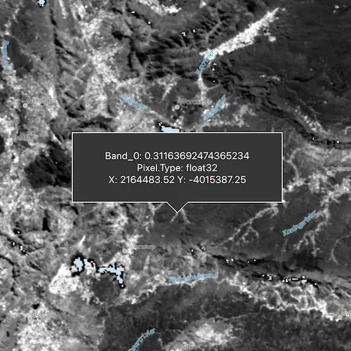
Get the cell value of a local raster at the tapped location and display the result in a callout.
Use case
You may want to identify a raster layer to get its exact cell value in case the approximate value conveyed by its symbology is not sufficient. The information available for the raster cell depends on the type of raster layer being identified. For example, a 3-band satellite or aerial image might provide 8-bit RGB values, whereas a digital elevation model (DEM) would provide floating point z values. By identifying a raster cell of a DEM, you can retrieve the precise elevation of a location.
How to use the sample
Tap on the raster or press on the raster, hold, and move around the raster to identify it and see the raster cell attributes information displayed in a callout.
How it works
- Connect to signals emmited by a
mouseClicked,mousePressedAndHeld, andmouseMovedon theMapView. - On tapped or pressed, held, and dragged:
- Call
identifyLayerAsync(...)passing in the raster layer, screen point, tolerance, whether to return popups only, and maximum number of results per layer. - Connect to the
identifyLayerCompletedto get the result of the identify and then get theGeoElementfrom the layer result and get anyRasterCells from them. - Create a callout at the calculated map point and populate the callout content with text from the
RasterCellattributes. - Show the callout.
- Call
Relevant API
- GeoView::identifyLayerAsync(…)
- IdentifyLayerResult
- RasterCell
- RasterCell::attributes
- RasterLayer
Offline data
To set up the sample’s offline data, see the Use offline data in the samples section of the Qt Samples repository overview.
| Link | Local Location |
|---|---|
| South Africa data | <userhome>/ArcGIS/Runtime/Data/raster/SA_EVI_8Day_03May20 |
About the data
The data shown is an NDVI classification derived from MODIS imagery between 27 Apr 2020 and 4 May 2020. It comes from the NASA Worldview application. In a normalized difference vegetation index, or NDVI, values range between -1 and +1 with the positive end of the spectrum showing green vegetation.
Tags
band, cell, cell value, continuous, discrete, identify, pixel, pixel value, raster
Sample code
// [WriteFile Name=IdentifyRasterCell, Category=Layers]// [Legal]// Copyright 2020 Esri.//// Licensed under the Apache License, Version 2.0 (the "License");// you may not use this file except in compliance with the License.// You may obtain a copy of the License at// http://www.apache.org/licenses/LICENSE-2.0//// Unless required by applicable law or agreed to in writing, software// distributed under the License is distributed on an "AS IS" BASIS,// WITHOUT WARRANTIES OR CONDITIONS OF ANY KIND, either express or implied.// See the License for the specific language governing permissions and// limitations under the License.// [Legal]
#ifdef PCH_BUILD#include "pch.hpp"#endif // PCH_BUILD
// sample headers#include "IdentifyRasterCell.h"
// ArcGIS Maps SDK headers#include "AttributeListModel.h"#include "CalloutData.h"#include "Envelope.h"#include "Error.h"#include "IdentifyLayerResult.h"#include "LayerListModel.h"#include "Map.h"#include "MapQuickView.h"#include "MapTypes.h"#include "Raster.h"#include "RasterCell.h"#include "RasterLayer.h"
// Qt headers#include <QFuture>#include <QStandardPaths>#include <QString>#include <QUuid>
// STL headers#include <memory>
using namespace Esri::ArcGISRuntime;
// helper method to get cross platform data pathnamespace{  QString defaultDataPath()  {    QString dataPath;
#ifdef Q_OS_IOS    dataPath = QStandardPaths::writableLocation(QStandardPaths::DocumentsLocation);#else    dataPath = QStandardPaths::writableLocation(QStandardPaths::HomeLocation);#endif
    return dataPath;  }} // namespace
IdentifyRasterCell::IdentifyRasterCell(QObject* parent /* = nullptr */) :  QObject(parent),  m_map(new Map(BasemapStyle::ArcGISOceans, this)){  // initialize the raster layer  const QString filepath = defaultDataPath() + "/ArcGIS/Runtime/Data/raster/SA_EVI_8Day_03May20/SA_EVI_8Day_03May20.tif";  Raster* raster = new Raster(filepath, this);  m_rasterLayer = new RasterLayer(raster, this);
  m_map->operationalLayers()->append(m_rasterLayer);}
IdentifyRasterCell::~IdentifyRasterCell() = default;
void IdentifyRasterCell::init(){  // Register the map view for QML  qmlRegisterType<MapQuickView>("Esri.Samples", 1, 0, "MapView");  qmlRegisterType<IdentifyRasterCell>("Esri.Samples", 1, 0, "IdentifyRasterCellSample");}
MapQuickView* IdentifyRasterCell::mapView() const{  return m_mapView;}
// Set the view (created in QML)void IdentifyRasterCell::setMapView(MapQuickView* mapView){  if (!mapView || mapView == m_mapView)  {    return;  }
  m_mapView = mapView;  m_mapView->setMap(m_map);
  connectSignals();
  emit mapViewChanged();}
void IdentifyRasterCell::connectSignals(){  connect(m_rasterLayer, &Layer::doneLoading, this, [this](const Error& error)  {    if (!error.isEmpty())    {      qDebug() << error.message() << error.additionalMessage();      return;    }
    m_mapView->setViewpointGeometryAsync(m_rasterLayer->fullExtent());  });
  connect(m_mapView, &MapQuickView::mouseClicked, this, [this](const QMouseEvent& e)  {    m_mapView->identifyLayerAsync(m_rasterLayer, e.position(), 10, false, 1)      .then(this, [this](IdentifyLayerResult* rawIdentifyResult)    {      onIdentifyLayerCompleted_(rawIdentifyResult);    });    m_clickedPoint = m_mapView->screenToLocation(e.position().x(), e.position().y());  });
  connect(m_mapView, &MapQuickView::mousePressedAndHeld, this, [this](const QMouseEvent& e)  {    m_mapView->identifyLayerAsync(m_rasterLayer, e.position(), 10, false, 1)      .then(this, [this](IdentifyLayerResult* rawIdentifyResult)    {      onIdentifyLayerCompleted_(rawIdentifyResult);    });    m_clickedPoint = m_mapView->screenToLocation(e.position().x(), e.position().y());    m_mousePressed = true;  });
  connect(m_mapView, &MapQuickView::mouseReleased, this, [this](QMouseEvent&)  {    m_mousePressed = false;  });
  // if mouse is moved after press-and-hold, then update callout on-the-fly  connect(m_mapView, &MapQuickView::mouseMoved, this, [this](const QMouseEvent& e)  {    if (m_mousePressed)    {      m_mapView->identifyLayerAsync(m_rasterLayer, e.position(), 10, false, 1)        .then(this, [this](IdentifyLayerResult* rawIdentifyResult)      {        onIdentifyLayerCompleted_(rawIdentifyResult);      });      m_clickedPoint = m_mapView->screenToLocation(e.position().x(), e.position().y());    }  });}
void IdentifyRasterCell::onIdentifyLayerCompleted_(IdentifyLayerResult* rawIdentifyResult){  const auto identifyResult = std::unique_ptr<IdentifyLayerResult>(rawIdentifyResult);  const auto elements = identifyResult->geoElements();  for (GeoElement* geoElement : elements)  {    if (RasterCell* rasterCell = dynamic_cast<RasterCell*>(geoElement))    {      QString calloutString;      const AttributeListModel* attributes = rasterCell->attributes();      const QStringList attributeNames = rasterCell->attributes()->attributeNames();
      for (int i = 0; i < attributeNames.size(); ++i)      {        const QString value = QVariant((*attributes)[attributeNames[i]]).toString();        calloutString.append(attributeNames[i] + ": " + value + "\n");      }
      const double xPoint = rasterCell->geometry().extent().xMin();      const double yPoint = rasterCell->geometry().extent().yMin();
      calloutString.append("X: " + QString::number(xPoint, 'f', 2) + " Y: " + QString::number(yPoint, 'f', 2));
      m_mapView->calloutData()->setLocation(m_clickedPoint);      m_mapView->calloutData()->setDetail(calloutString);      m_mapView->calloutData()->setVisible(true);      m_calloutData = m_mapView->calloutData();      emit calloutDataChanged();    }  }}
CalloutData* IdentifyRasterCell::calloutData() const{  return m_calloutData;}
// [WriteFile Name=IdentifyRasterCell, Category=Layers]// [Legal]// Copyright 2020 Esri.//// Licensed under the Apache License, Version 2.0 (the "License");// you may not use this file except in compliance with the License.// You may obtain a copy of the License at// http://www.apache.org/licenses/LICENSE-2.0//// Unless required by applicable law or agreed to in writing, software// distributed under the License is distributed on an "AS IS" BASIS,// WITHOUT WARRANTIES OR CONDITIONS OF ANY KIND, either express or implied.// See the License for the specific language governing permissions and// limitations under the License.// [Legal]
#ifndef IDENTIFYRASTERCELL_H#define IDENTIFYRASTERCELL_H
// ArcGIS Maps SDK headers#include "Point.h"
// Qt headers#include <QObject>
namespace Esri::ArcGISRuntime{ class CalloutData; class IdentifyLayerResult; class Map; class MapQuickView; class RasterLayer;} // namespace Esri::ArcGISRuntime
Q_MOC_INCLUDE("MapQuickView.h")Q_MOC_INCLUDE("CalloutData.h")
class IdentifyRasterCell : public QObject{ Q_OBJECT
Q_PROPERTY(Esri::ArcGISRuntime::MapQuickView* mapView READ mapView WRITE setMapView NOTIFY mapViewChanged) Q_PROPERTY(Esri::ArcGISRuntime::CalloutData* calloutData READ calloutData NOTIFY calloutDataChanged)
public: explicit IdentifyRasterCell(QObject* parent = nullptr); ~IdentifyRasterCell();
static void init();
signals: void mapViewChanged(); void calloutDataChanged();
private: Esri::ArcGISRuntime::MapQuickView* mapView() const; void setMapView(Esri::ArcGISRuntime::MapQuickView* mapView); Esri::ArcGISRuntime::CalloutData* calloutData() const; void connectSignals(); void onIdentifyLayerCompleted_(Esri::ArcGISRuntime::IdentifyLayerResult* rawIdentifyResult);
Esri::ArcGISRuntime::Map* m_map = nullptr; Esri::ArcGISRuntime::MapQuickView* m_mapView = nullptr; Esri::ArcGISRuntime::RasterLayer* m_rasterLayer = nullptr; Esri::ArcGISRuntime::CalloutData* m_calloutData = nullptr; Esri::ArcGISRuntime::Point m_clickedPoint; bool m_mousePressed = false;};
#endif // IDENTIFYRASTERCELL_H// [WriteFile Name=IdentifyRasterCell, Category=Layers]// [Legal]// Copyright 2020 Esri.//// Licensed under the Apache License, Version 2.0 (the "License");// you may not use this file except in compliance with the License.// You may obtain a copy of the License at// http://www.apache.org/licenses/LICENSE-2.0//// Unless required by applicable law or agreed to in writing, software// distributed under the License is distributed on an "AS IS" BASIS,// WITHOUT WARRANTIES OR CONDITIONS OF ANY KIND, either express or implied.// See the License for the specific language governing permissions and// limitations under the License.// [Legal]
import QtQuickimport QtQuick.Controlsimport Esri.Samplesimport Esri.ArcGISRuntime.Toolkit
Item {
// add a mapView component MapView { id: view anchors.fill: parent
Component.onCompleted: { // Set the focus on MapView to initially enable keyboard navigation forceActiveFocus(); }
Callout { id: callout calloutData: view.calloutData implicitWidth: 300 contentItem: Label { id: customComponentText text: view.calloutData.detail wrapMode: Text.WordWrap horizontalAlignment: Qt.AlignHCenter verticalAlignment: Qt.AlignVCenter } } }
// Declare the C++ instance which creates the map etc. and supply the view IdentifyRasterCellSample { id: model mapView: view }}