Control the behavior of the camera in a scene.
Use Case
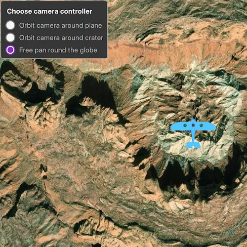
The globe camera controller (the default camera controller in all new scenes) allows a user to explore the scene freely by zooming in/out and panning around the globe. The orbit camera controllers fix the camera to look at a target location or geoelement. A primary use case is for following moving objects like cars and planes.
How to use the sample
The application loads with the default globe camera controller. To rotate and fix the scene around the plane, exit globe mode by choosing the “Orbit camera around plane” option (i.e. camera will now be fixed to the plane). Choose the “Orbit camera around crater” option to rotate and center the scene around the location of the Upheaval Dome crater structure, or choose the “Free pan round the globe” option to return to default free navigation.
How it works
- Create an instance of a class extending
CameraController:GlobeCameraController,OrbitLocationCameraController,OrbitGeoElementCameraController. - Set the scene view’s camera controller with
sceneView.setCameraController(cameraController).
Relevant API
- Scene
- Camera
- GlobeCameraController
- OrbitGeoElementCameraController
- OrbitLocationCameraController
- SceneView
Tags
camera controller, Camera, SceneView, 3D
Sample code
// [WriteFile Name=ChooseCameraController, Category=Scenes]// [Legal]// Copyright 2019 Esri.//// Licensed under the Apache License, Version 2.0 (the "License");// you may not use this file except in compliance with the License.// You may obtain a copy of the License at// http://www.apache.org/licenses/LICENSE-2.0//// Unless required by applicable law or agreed to in writing, software// distributed under the License is distributed on an "AS IS" BASIS,// WITHOUT WARRANTIES OR CONDITIONS OF ANY KIND, either express or implied.// See the License for the specific language governing permissions and// limitations under the License.// [Legal]
#ifdef PCH_BUILD#include "pch.hpp"#endif // PCH_BUILD
// sample headers#include "ChooseCameraController.h"
// ArcGIS Maps SDK headers#include "ArcGISTiledElevationSource.h"#include "Camera.h"#include "ElevationSourceListModel.h"#include "GlobeCameraController.h"#include "Graphic.h"#include "GraphicListModel.h"#include "GraphicsOverlay.h"#include "GraphicsOverlayListModel.h"#include "LayerSceneProperties.h"#include "MapTypes.h"#include "ModelSceneSymbol.h"#include "OrbitGeoElementCameraController.h"#include "OrbitLocationCameraController.h"#include "Point.h"#include "Scene.h"#include "SceneQuickView.h"#include "SceneViewTypes.h"#include "SpatialReference.h"#include "Surface.h"
// Qt headers#include <QFuture>#include <QStandardPaths>#include <QtCore/qglobal.h>
namespace{  const double longitude = -109.929589;  const double latitude = 38.43500;  const double distance = 5000;
  QString defaultDataPath()  {    QString dataPath;
#ifdef Q_OS_IOS    dataPath = QStandardPaths::writableLocation(QStandardPaths::DocumentsLocation);#else    dataPath = QStandardPaths::writableLocation(QStandardPaths::HomeLocation);#endif
    return dataPath;  }} // namespace
using namespace Esri::ArcGISRuntime;
ChooseCameraController::ChooseCameraController(QObject* parent /* = nullptr */) :  QObject(parent),  m_orbitGlobe(new GlobeCameraController(this)),  m_orbitLocation(new OrbitLocationCameraController(Point(longitude, latitude, 0.0, SpatialReference::wgs84()), 100, this)),  m_scene(new Scene(BasemapStyle::ArcGISImageryStandard, this)){  // create a new elevation source from Terrain3D REST service  ArcGISTiledElevationSource* elevationSource =    new ArcGISTiledElevationSource(QUrl("https://elevation3d.arcgis.com/arcgis/rest/services/WorldElevation3D/Terrain3D/ImageServer"), this);
  // add the elevation source to the scene to display elevation  m_scene->baseSurface()->elevationSources()->append(elevationSource);
  m_orbitLocation->setCameraDistance(distance);
  // get the data path  QUrl dataUrl(defaultDataPath() + "/ArcGIS/Runtime/Data/3D/Bristol/Collada/Bristol.dae");  ModelSceneSymbol* planeModel = new ModelSceneSymbol(dataUrl, 10.0f, this);
  Esri::ArcGISRuntime::Graphic* graphic = new Graphic(Point(longitude, latitude, distance / 2), planeModel, this);
  m_overlay = new GraphicsOverlay(this);
  m_overlay->setSceneProperties(LayerSceneProperties(SurfacePlacement::Relative));  m_overlay->graphics()->append(graphic);  m_orbitGeoElement = new OrbitGeoElementCameraController(graphic, distance / 2, this);}
ChooseCameraController::~ChooseCameraController() = default;
void ChooseCameraController::setGlobeController(){  if (m_sceneView != nullptr)  {    m_sceneView->setCameraController(m_orbitGlobe);  }}
void ChooseCameraController::setOrbitLocationController(){  if (m_sceneView != nullptr)  {    m_sceneView->setCameraController(m_orbitLocation);  }}
void ChooseCameraController::setOrbitGeoElementController(){  if (m_sceneView != nullptr)  {    m_sceneView->setCameraController(m_orbitGeoElement);  }}
void ChooseCameraController::init(){  // Register classes for QML  qmlRegisterType<SceneQuickView>("Esri.Samples", 1, 0, "SceneView");  qmlRegisterType<ChooseCameraController>("Esri.Samples", 1, 0, "ChooseCameraControllerSample");}
SceneQuickView* ChooseCameraController::sceneView() const{  return m_sceneView;}
// Set the view (created in QML)void ChooseCameraController::setSceneView(SceneQuickView* sceneView){  if (!sceneView || sceneView == m_sceneView)  {    return;  }
  m_sceneView = sceneView;  m_sceneView->setViewpointCameraAsync(Camera(latitude, longitude, distance, 0.0, 0.0, 0.0));  m_sceneView->setArcGISScene(m_scene);  m_sceneView->graphicsOverlays()->append(m_overlay);
  emit sceneViewChanged();}
// [WriteFile Name=ChooseCameraController, Category=Scenes]// [Legal]// Copyright 2019 Esri.//// Licensed under the Apache License, Version 2.0 (the "License");// you may not use this file except in compliance with the License.// You may obtain a copy of the License at// http://www.apache.org/licenses/LICENSE-2.0//// Unless required by applicable law or agreed to in writing, software// distributed under the License is distributed on an "AS IS" BASIS,// WITHOUT WARRANTIES OR CONDITIONS OF ANY KIND, either express or implied.// See the License for the specific language governing permissions and// limitations under the License.// [Legal]
#ifndef CHOOSECAMERACONTROLLER_H#define CHOOSECAMERACONTROLLER_H
// Qt headers#include <QObject>
namespace Esri::ArcGISRuntime{ class GlobeCameraController; class GraphicsOverlay; class OrbitGeoElementCameraController; class OrbitLocationCameraController; class Scene; class SceneQuickView;} // namespace Esri::ArcGISRuntime
Q_MOC_INCLUDE("SceneQuickView.h")
class ChooseCameraController : public QObject{ Q_OBJECT
Q_PROPERTY(Esri::ArcGISRuntime::SceneQuickView* sceneView READ sceneView WRITE setSceneView NOTIFY sceneViewChanged)
public: explicit ChooseCameraController(QObject* parent = nullptr); ~ChooseCameraController();
Q_INVOKABLE void setGlobeController(); Q_INVOKABLE void setOrbitLocationController(); Q_INVOKABLE void setOrbitGeoElementController();
static void init();
signals: void sceneViewChanged();
private: Esri::ArcGISRuntime::SceneQuickView* sceneView() const; void setSceneView(Esri::ArcGISRuntime::SceneQuickView* sceneView);
Esri::ArcGISRuntime::GlobeCameraController* m_orbitGlobe = nullptr; Esri::ArcGISRuntime::OrbitGeoElementCameraController* m_orbitGeoElement = nullptr; Esri::ArcGISRuntime::OrbitLocationCameraController* m_orbitLocation = nullptr;
Esri::ArcGISRuntime::Scene* m_scene = nullptr; Esri::ArcGISRuntime::SceneQuickView* m_sceneView = nullptr;
Esri::ArcGISRuntime::GraphicsOverlay* m_overlay;};
#endif // CHOOSECAMERACONTROLLER_H// [WriteFile Name=ChooseCameraController, Category=Scenes]// [Legal]// Copyright 2019 Esri.//// Licensed under the Apache License, Version 2.0 (the "License");// you may not use this file except in compliance with the License.// You may obtain a copy of the License at// http://www.apache.org/licenses/LICENSE-2.0//// Unless required by applicable law or agreed to in writing, software// distributed under the License is distributed on an "AS IS" BASIS,// WITHOUT WARRANTIES OR CONDITIONS OF ANY KIND, either express or implied.// See the License for the specific language governing permissions and// limitations under the License.// [Legal]
import QtQuickimport QtQuick.Controlsimport Esri.Samplesimport QtQuick.Layouts
Item {
SceneView { id: view anchors.fill: parent
Component.onCompleted: { // Set the focus on SceneView to initially enable keyboard navigation forceActiveFocus(); } }
// Declare the C++ instance which creates the scene etc. and supply the view ChooseCameraControllerSample { id: chooseCameraControllerSample sceneView: view }
// Create a rectangle to display the GUI Rectangle { width: columnLayout.implicitWidth + 16 height: columnLayout.implicitHeight + 16 color: palette.base radius: 5 anchors { margins: 10 left: parent.left top: parent.top } border { color: "darkgrey" width: 1 }
MouseArea { anchors.fill: parent acceptedButtons: Qt.LeftButton | Qt.RightButton onClicked: mouse => mouse.accepted = true onDoubleClicked: mouse => mouse.accepted = true onWheel: wheel => wheel.accepted = true } ColumnLayout { id: columnLayout anchors.centerIn: parent Label { Layout.margins: 5 Layout.fillWidth: true text: qsTr("Choose camera controller") clip: true font { pointSize: 14 bold: true } }
RadioButton { Layout.fillWidth: true id: orbitAroundAeroplane text: qsTr("Orbit camera around plane") onCheckedChanged: { if (checked) { chooseCameraControllerSample.setOrbitGeoElementController(); } } }
RadioButton { Layout.fillWidth: true id: orbitLocation text: qsTr("Orbit camera around crater") onCheckedChanged: { if (checked) { chooseCameraControllerSample.setOrbitLocationController(); } } }
RadioButton { Layout.fillWidth: true id: orbitAroundGlobe checked: true text: qsTr("Free pan round the globe") onCheckedChanged: { if (checked) { chooseCameraControllerSample.setGlobeController(); } } } } }}