Use annotation sublayers to gain finer control of annotation layer subtypes.
Use case
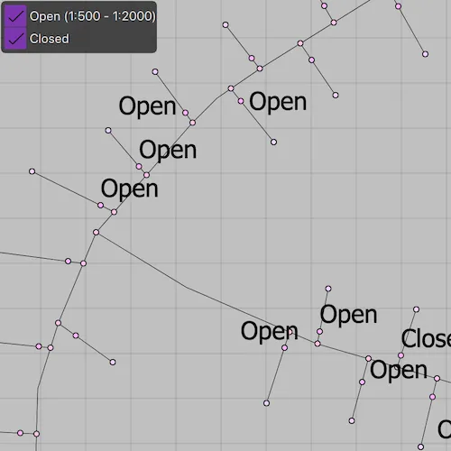
Annotation, which differs from labels by having a fixed place and size, is typically only relevant at particular scales. Annotation sublayers allow for finer control of annotation by allowing properties (like visibility in the map and legend) to be set and others to be read (like name) on subtypes of an annotation layer.
An annotation dataset which marks valves as “Opened” or “Closed”, might be set to display the “Closed” valves over a broader range of scales than the “Opened” valves, if the “Closed” data is considered more relevant by the map’s author. Regardless, the user can be given a manual option to set visibility of annotation sublayers on and off, if required.
How to use the sample
Start the sample and take note of the visibility of the annotation. Zoom in and out to see the annotation turn on and off based on scale ranges set on the data.
Use the checkboxes to manually set “Open” and “Closed” annotation sublayers visibility to on or off.
How it works
- Load a
MobileMapPackagethat containsAnnotationSublayer. - Get the sublayers from the map package’s layers by calling
sublayer::subLayerContents()[i]. - You can toggle the visibility of each sublayer manually using
sublayer::setVisible(). - To determine if a sublayer is visible at the current scale of the
MapView, usesublayer::isVisibleAtScale(), by passing in the map’s current scale.
Relevant API
- AnnotationLayer
- AnnotationSublayer
- LayerContent
Offline Data
Read more about how to set up the sample’s offline data here.
| Link | Local Location |
|---|---|
| Gas Device Anno Mobile Map Package | <userhome>/ArcGIS/Runtime/Data/mmpk/GasDeviceAnno.mmpk |
About the data
The scale ranges were set by the map’s author using ArcGIS Pro:
- The “Open” annotation sublayer has its maximum scale set to 1:500 and its minimum scale set to 1:2000.
- The “Closed” annotation sublayer has no minimum or maximum scales set, so will be drawn at all scales.
Tags
annotation, scale, text, utilities, visualization
Sample code
// [WriteFile Name=ControlAnnotationSublayerVisibility, Category=DisplayInformation]// [Legal]// Copyright 2019 Esri.//// Licensed under the Apache License, Version 2.0 (the "License");// you may not use this file except in compliance with the License.// You may obtain a copy of the License at// http://www.apache.org/licenses/LICENSE-2.0//// Unless required by applicable law or agreed to in writing, software// distributed under the License is distributed on an "AS IS" BASIS,// WITHOUT WARRANTIES OR CONDITIONS OF ANY KIND, either express or implied.// See the License for the specific language governing permissions and// limitations under the License.// [Legal]
#ifdef PCH_BUILD#include "pch.hpp"#endif // PCH_BUILD
// sample headers#include "ControlAnnotationSublayerVisibility.h"
// ArcGIS Maps SDK headers#include "AnnotationSublayer.h"#include "Error.h"#include "Layer.h"#include "LayerListModel.h"#include "Map.h"#include "MapQuickView.h"#include "MapTypes.h"#include "MobileMapPackage.h"
// Qt headers#include <QStandardPaths>#include <QtCore/qglobal.h>
using namespace Esri::ArcGISRuntime;
// helper method to get cross platform data pathnamespace{  QString defaultDataPath()  {    QString dataPath;
#ifdef Q_OS_IOS    dataPath = QStandardPaths::writableLocation(QStandardPaths::DocumentsLocation);#else    dataPath = QStandardPaths::writableLocation(QStandardPaths::HomeLocation);#endif
    return dataPath;  }
  // sample MMPK location  const QString sampleFileAnno{"/ArcGIS/Runtime/Data/mmpk/GasDeviceAnno.mmpk"};
} // namespace
ControlAnnotationSublayerVisibility::ControlAnnotationSublayerVisibility(QObject* parent /* = nullptr */) :  QObject(parent){  const QString dataPath = defaultDataPath() + sampleFileAnno;
  // Load the MMPK  createMapPackage(dataPath);}
ControlAnnotationSublayerVisibility::~ControlAnnotationSublayerVisibility() = default;
void ControlAnnotationSublayerVisibility::init(){  // Register the map view for QML  qmlRegisterType<MapQuickView>("Esri.Samples", 1, 0, "MapView");  qmlRegisterType<ControlAnnotationSublayerVisibility>("Esri.Samples", 1, 0, "ControlAnnotationSublayerVisibilitySample");}
MapQuickView* ControlAnnotationSublayerVisibility::mapView() const{  return m_mapView;}
// Set the view (created in QML)void ControlAnnotationSublayerVisibility::setMapView(MapQuickView* mapView){  if (!mapView || mapView == m_mapView)  {    return;  }
  m_mapView = mapView;  m_mapView->setMap(m_map);
  connect(m_mapView, &MapQuickView::mapScaleChanged, this, [this]()  {    m_mapScale = m_mapView->mapScale();    emit mapScaleChanged();
    recalculateVisibleAtCurrentExtent();  });
  emit mapViewChanged();}
// create map packagevoid ControlAnnotationSublayerVisibility::createMapPackage(const QString& path){  //! [open mobile map package cpp snippet]  // instatiate a mobile map package  m_mobileMapPackage = new MobileMapPackage(path, this);
  // connect to the Mobile Map Package errorOccurred to know when errors occur  connect(m_mobileMapPackage, &MobileMapPackage::errorOccurred, [](const Error& error)  {    if (error.isEmpty())    {      return;    }
    qDebug() << QString("Error: %1 %2").arg(error.message(), error.additionalMessage());  });
  // wait for the mobile map package to load  connect(m_mobileMapPackage, &MobileMapPackage::doneLoading, this, [this](const Error& error)  {    if (!error.isEmpty())    {      qDebug() << QString("Package load error: %1 %2").arg(error.message(), error.additionalMessage());      return;    }
    if (!m_mobileMapPackage || !m_mapView || m_mobileMapPackage->maps().isEmpty())    {      return;    }
    // The package contains a list of maps that could be shown in the UI for selection.    // For simplicity, obtain the first map in the list of maps.    // set the map on the map view to display    m_mapView->setMap(m_mobileMapPackage->maps().at(0));
    m_layerListModel = mapView()->map()->operationalLayers();    for (Layer* layer : *m_layerListModel)    {      if (layer->layerType() == LayerType::AnnotationLayer)      {        m_annoLayer = layer;        connect(m_annoLayer, &Layer::doneLoading, this, [this](const Error& error)        {          if (!error.isEmpty())          {            qDebug() << QString("Package load error: %1 %2").arg(error.message(), error.additionalMessage());            return;          }
          const QList<LayerContent*> contents = m_annoLayer->subLayerContents();          m_annotationSubLayerClosed = dynamic_cast<AnnotationSublayer*>(contents[0]);          m_annotationSubLayerOpen = dynamic_cast<AnnotationSublayer*>(contents[1]);          m_closedLayerText = m_annotationSubLayerClosed->name();          m_openLayerText = QString("%1 (1:%2 - 1:%3)")                              .arg(m_annotationSubLayerOpen->name())                              .arg(m_annotationSubLayerOpen->maxScale())                              .arg(m_annotationSubLayerOpen->minScale());          emit openLayerTextChanged();          emit closedLayerTextChanged();          recalculateVisibleAtCurrentExtent();        });        layer->load();      }    }  });
  m_mobileMapPackage->load();  //! [open mobile map package cpp snippet]}
void ControlAnnotationSublayerVisibility::openLayerVisible(){  if (!m_annotationSubLayerOpen)  {    return;  }
  m_annotationSubLayerOpen->setVisible(!m_annotationSubLayerOpen->isVisible());}
void ControlAnnotationSublayerVisibility::closedLayerVisible(){  if (!m_annotationSubLayerClosed)  {    return;  }
  m_annotationSubLayerClosed->setVisible(!m_annotationSubLayerClosed->isVisible());}
void ControlAnnotationSublayerVisibility::recalculateVisibleAtCurrentExtent(){  const bool visibleAtCurrentExtent = m_annotationSubLayerOpen ? m_annotationSubLayerOpen->isVisibleAtScale(m_mapScale) : false;  if (m_visibleAtCurrentExtent != visibleAtCurrentExtent)  {    m_visibleAtCurrentExtent = visibleAtCurrentExtent;    emit visibleAtCurrentExtentChanged();  }}
// [WriteFile Name=ControlAnnotationSublayerVisibility, Category=DisplayInformation]// [Legal]// Copyright 2019 Esri.//// Licensed under the Apache License, Version 2.0 (the "License");// you may not use this file except in compliance with the License.// You may obtain a copy of the License at// http://www.apache.org/licenses/LICENSE-2.0//// Unless required by applicable law or agreed to in writing, software// distributed under the License is distributed on an "AS IS" BASIS,// WITHOUT WARRANTIES OR CONDITIONS OF ANY KIND, either express or implied.// See the License for the specific language governing permissions and// limitations under the License.// [Legal]
#ifndef CONTROLANNOTATIONSUBLAYERVISIBILITY_H#define CONTROLANNOTATIONSUBLAYERVISIBILITY_H
// Qt headers#include <QObject>
namespace Esri::ArcGISRuntime{ class Map; class MapQuickView; class MobileMapPackage; class AnnotationSublayer; class LayerListModel; class Layer;} // namespace Esri::ArcGISRuntime
Q_MOC_INCLUDE("MapQuickView.h")
class ControlAnnotationSublayerVisibility : public QObject{ Q_OBJECT
Q_PROPERTY(Esri::ArcGISRuntime::MapQuickView* mapView READ mapView WRITE setMapView NOTIFY mapViewChanged) Q_PROPERTY(QString openLayerText MEMBER m_openLayerText NOTIFY openLayerTextChanged) Q_PROPERTY(QString closedLayerText MEMBER m_closedLayerText NOTIFY closedLayerTextChanged) Q_PROPERTY(double mapScale MEMBER m_mapScale NOTIFY mapScaleChanged()) Q_PROPERTY(bool visibleAtCurrentExtent MEMBER m_visibleAtCurrentExtent NOTIFY visibleAtCurrentExtentChanged())
public: explicit ControlAnnotationSublayerVisibility(QObject* parent = nullptr); ~ControlAnnotationSublayerVisibility();
static void init();
Q_INVOKABLE void openLayerVisible(); Q_INVOKABLE void closedLayerVisible();
signals: void mapViewChanged(); void openLayerTextChanged(); void closedLayerTextChanged(); void mapScaleChanged(); void visibleAtCurrentExtentChanged();
private: Esri::ArcGISRuntime::MapQuickView* mapView() const; void setMapView(Esri::ArcGISRuntime::MapQuickView* mapView); void createMapPackage(const QString& path); void recalculateVisibleAtCurrentExtent();
Esri::ArcGISRuntime::Map* m_map = nullptr; Esri::ArcGISRuntime::MapQuickView* m_mapView = nullptr; Esri::ArcGISRuntime::MobileMapPackage* m_mobileMapPackage = nullptr; Esri::ArcGISRuntime::AnnotationSublayer* m_annotationSubLayerOpen = nullptr; Esri::ArcGISRuntime::AnnotationSublayer* m_annotationSubLayerClosed = nullptr; Esri::ArcGISRuntime::LayerListModel* m_layerListModel = nullptr; Esri::ArcGISRuntime::Layer* m_annoLayer = nullptr;
QString m_openLayerText; QString m_closedLayerText; bool m_visibleAtCurrentExtent = false; double m_mapScale = 0.0;};
#endif // CONTROLANNOTATIONSUBLAYERVISIBILITY_H// [WriteFile Name=ControlAnnotationSublayerVisibility, Category=DisplayInformation]// [Legal]// Copyright 2019 Esri.//// Licensed under the Apache License, Version 2.0 (the "License");// you may not use this file except in compliance with the License.// You may obtain a copy of the License at// http://www.apache.org/licenses/LICENSE-2.0//// Unless required by applicable law or agreed to in writing, software// distributed under the License is distributed on an "AS IS" BASIS,// WITHOUT WARRANTIES OR CONDITIONS OF ANY KIND, either express or implied.// See the License for the specific language governing permissions and// limitations under the License.// [Legal]
import QtQuickimport QtQuick.Layoutsimport QtQuick.Controlsimport Esri.Samples
Item { // add a mapView component MapView { id: view anchors.fill: parent
Component.onCompleted: { // Set the focus on MapView to initially enable keyboard navigation forceActiveFocus(); }
Rectangle { id: checkBoxBackground anchors { left: parent.left top: parent.top margins: 2 } width: columnLayout.implicitWidth height: columnLayout.implicitHeight + 16 color: palette.base opacity: .9 radius: 5
ColumnLayout { id: columnLayout spacing: 8 anchors.centerIn: parent Row { CheckBox { id: openBox checked: true onCheckStateChanged: controlAnnotationSublayerVisibilityModel.openLayerVisible(); }
Label { id: openBoxText text: controlAnnotationSublayerVisibilityModel.openLayerText anchors.verticalCenter: openBox.verticalCenter color: scale.color } }
Row { CheckBox { id: closedBox checked: true onCheckStateChanged: controlAnnotationSublayerVisibilityModel.closedLayerVisible(); }
Label { id: closedBoxText text: controlAnnotationSublayerVisibilityModel.closedLayerText anchors.verticalCenter: closedBox.verticalCenter } } } }
Rectangle { id: currentScale anchors { bottom: view.attributionTop horizontalCenter: parent.horizontalCenter } width: childrenRect.width height: childrenRect.height color: palette.base
Label { id: scale text: qsTr("Current map scale: 1:%1".arg(Math.round(controlAnnotationSublayerVisibilityModel.mapScale))) color: controlAnnotationSublayerVisibilityModel.visibleAtCurrentExtent ? palette.text : "grey" padding: 2 } } }
// Declare the C++ instance which creates the map etc. and supply the view ControlAnnotationSublayerVisibilitySample { id: controlAnnotationSublayerVisibilityModel mapView: view }}