Change the style of a Web Map Service (WMS) layer.
Use case
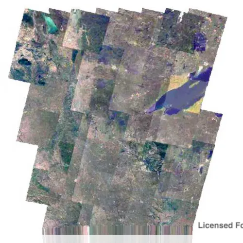
Layers hosted on WMS may have different pre-set styles available to apply to them. Swapping between these styles can help during visual examination of the data. For example, increasing the contrast of satellite images can help in identifying urban and agricultural areas within forested areas.
How to use the sample
Select one of the styles and the map will update the display with the selected style.
How it works
- Create a
WmsLayerspecifying the URL of the service and the layer names you wantnew WmsLayer(url, names). - When the layer is done loading, get it’s list of style strings using
wmsLayer::sublayers()::at(0)::sublayerInfo()::styles(). - Set one of the styles using
wmsLayer::sublayers()::at(0)::setCurrentStyle(styleString).
Relevant API
- WmsLayer
- WmsSublayer
- WmsSublayer::currentStyle
- WmsSublayerInfo
About the data
This sample uses a public service managed by the State of Minnesota and provides composite imagery for the state and the surrounding areas.
Tags
imagery, styles, visualization, WMS
Sample code
// [WriteFile Name=StyleWmsLayer, Category=Layers]// [Legal]// Copyright 2018 Esri.//// Licensed under the Apache License, Version 2.0 (the "License");// you may not use this file except in compliance with the License.// You may obtain a copy of the License at// http://www.apache.org/licenses/LICENSE-2.0//// Unless required by applicable law or agreed to in writing, software// distributed under the License is distributed on an "AS IS" BASIS,// WITHOUT WARRANTIES OR CONDITIONS OF ANY KIND, either express or implied.// See the License for the specific language governing permissions and// limitations under the License.// [Legal]
#ifdef PCH_BUILD#include "pch.hpp"#endif // PCH_BUILD
// sample headers#include "StyleWmsLayer.h"
// ArcGIS Maps SDK headers#include "Envelope.h"#include "Error.h"#include "LayerListModel.h"#include "Map.h"#include "MapQuickView.h"#include "SpatialReference.h"#include "WmsLayer.h"#include "WmsLayerInfo.h"#include "WmsSublayer.h"
// Qt headers#include <QFuture>
using namespace Esri::ArcGISRuntime;
StyleWmsLayer::StyleWmsLayer(QQuickItem* parent /* = nullptr */) :  QQuickItem(parent){}
void StyleWmsLayer::init(){  // Register the map view for QML  qmlRegisterType<MapQuickView>("Esri.Samples", 1, 0, "MapView");  qmlRegisterType<StyleWmsLayer>("Esri.Samples", 1, 0, "StyleWmsLayerSample");}
void StyleWmsLayer::componentComplete(){  QQuickItem::componentComplete();
  // find QML MapView component  m_mapView = findChild<MapQuickView*>("mapView");
  // Create a map with spatial reference appropriate for the WMS service (North American Datum 83)  m_map = new Map(SpatialReference(26915), this);  m_map->setMinScale(7'000'000);
  // Add a WMS Layer  WmsLayer* wmsLayer = new WmsLayer(QUrl("https://imageserver.gisdata.mn.gov/cgi-bin/mncomp?SERVICE=WMS&VERSION=1.3.0&REQUEST=GetCapabilities"),                                    QStringList{"mncomp"}, this);  m_map->operationalLayers()->append(wmsLayer);
  // connect to the doneLoading signal of the WMS Layer  connect(wmsLayer, &WmsLayer::doneLoading, this, [this, wmsLayer](const Error& e)  {    if (!e.isEmpty())    {      return;    }
    // zoom to the layer    m_mapView->setViewpointGeometryAsync(wmsLayer->fullExtent());
    // get the subLayer    if (!wmsLayer->sublayers().empty())    {      m_wmsSublayer = wmsLayer->sublayers().at(0);    }  });
  // Set map to map view  m_mapView->setMap(m_map);}
void StyleWmsLayer::setCurrentStyle(int index){  if (!m_wmsSublayer)  {    return;  }
  // get the styles  const QStringList styles = m_wmsSublayer->sublayerInfo().styles();  if (styles.length() < index + 1)  {    return;  }
  // get the style  const QString style = styles.at(index);
  // set the style on the WMS Sublayer  m_wmsSublayer->setCurrentStyle(style);}
// [WriteFile Name=StyleWmsLayer, Category=Layers]// [Legal]// Copyright 2018 Esri.//// Licensed under the Apache License, Version 2.0 (the "License");// you may not use this file except in compliance with the License.// You may obtain a copy of the License at// http://www.apache.org/licenses/LICENSE-2.0//// Unless required by applicable law or agreed to in writing, software// distributed under the License is distributed on an "AS IS" BASIS,// WITHOUT WARRANTIES OR CONDITIONS OF ANY KIND, either express or implied.// See the License for the specific language governing permissions and// limitations under the License.// [Legal]
#ifndef STYLEWMSLAYER_H#define STYLEWMSLAYER_H
// Qt headers#include <QQuickItem>
namespace Esri::ArcGISRuntime{ class Map; class MapQuickView; class WmsSublayer;} // namespace Esri::ArcGISRuntime
class StyleWmsLayer : public QQuickItem{ Q_OBJECT
public: explicit StyleWmsLayer(QQuickItem* parent = nullptr); ~StyleWmsLayer() override = default;
void componentComplete() override; static void init(); Q_INVOKABLE void setCurrentStyle(int index);
private: Esri::ArcGISRuntime::Map* m_map = nullptr; Esri::ArcGISRuntime::MapQuickView* m_mapView = nullptr; Esri::ArcGISRuntime::WmsSublayer* m_wmsSublayer = nullptr;};
#endif // STYLEWMSLAYER_H// [WriteFile Name=StyleWmsLayer, Category=Layers]// [Legal]// Copyright 2018 Esri.//// Licensed under the Apache License, Version 2.0 (the "License");// you may not use this file except in compliance with the License.// You may obtain a copy of the License at// http://www.apache.org/licenses/LICENSE-2.0//// Unless required by applicable law or agreed to in writing, software// distributed under the License is distributed on an "AS IS" BASIS,// WITHOUT WARRANTIES OR CONDITIONS OF ANY KIND, either express or implied.// See the License for the specific language governing permissions and// limitations under the License.// [Legal]
import QtQuickimport QtQuick.Windowimport QtQuick.Controlsimport Esri.Samples
StyleWmsLayerSample { id: rootRectangle clip: true width: 800 height: 600
// add a mapView component MapView { anchors.fill: parent objectName: "mapView"
Component.onCompleted: { // Set the focus on MapView to initially enable keyboard navigation forceActiveFocus(); } }
Rectangle { anchors { fill: controlColumn margins: -5 } color: palette.base radius: 5
border { width: 1 color: "darkgrey" } }
ButtonGroup { buttons: controlColumn.children }
Column { id: controlColumn anchors { left: parent.left top: parent.top margins: 10 } spacing: 5
RadioButton { text: qsTr("Default") checked: true onCheckedChanged: { if (checked) { // set the style string on the sublayer setCurrentStyle(0); } } }
RadioButton { text: qsTr("Contrast Stretch") onCheckedChanged: { if (checked) { // set the style string on the sublayer setCurrentStyle(1); } } } }}