Find features in a sublayer based on attributes and location.
Use case
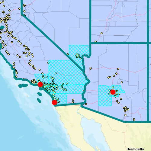
Sublayers of an ArcGISMapImageLayer may expose a ServiceFeatureTable through a table property. This allows you to perform the same queries available when working with a table from a FeatureLayer: attribute query, spatial query, statistics query, query for related features, etc. An image layer with a sublayer of counties can be queried by population to only show those above a minimum population.
How to use the sample
Specify a minimum population in the input field (values under 1810000 will produce a selection in all layers) and click the query button to query the sublayers in the current view extent. After a short time, the results for each sublayer will appear as graphics.
How it works
- Create an
ArcGISMapImageLayerobject using the URL of an image service. - After loading the layer, get the sublayer you want to query with
(ArcGISMapImageSublayer) layer::subLayers()::at(index). - Load the sublayer, and then get its
ServiceFeatureTablewithsublayer::table(). - Create
QueryParameters. You can usequeryParameters::setWhereClause(sqlQueryString)to query against a table attribute and/or setqueryParameters::setGeometry(extent)to limit the results to an area of the map. - Call
sublayerTable::queryFeaturesAsync(queryParameters)to get aFeatureQueryResultwith features matching the query. The result is an iterable of features.
Relevant API
- ArcGISMapImageLayer
- ArcGISMapImageLayer::loadTablesAndLayersAsync
- ArcGISMapImageSublayer
- ArcGISMapImageSublayer::table
- QueryParameters
- ServiceFeatureTable
About the data
The ArcGISMapImageLayer in the map uses the “USA” map service as its data source. This service is hosted by ArcGIS Online, and is composed of four sublayers: “states”, “counties”, “cities”, and “highways”.
Since the cities, counties, and states tables all have a POP2000 field, they can all execute a query against that attribute and a map extent.
Additional information
An ArcGISMapImageSublayer must be loaded before accessing its metadata or table. Use ArcGISMapImageLayer::loadTablesAndLayersAsync to recursively load all sublayers and tables associated with a map image layer. Some sublayers do not have an associated table (group layers, for example) and some may not support specific types of queries. Consult the map service metadata for details.
Tags
MapServer, Query, Sublayer, Table
Sample code
// [WriteFile Name=QueryMapImageSublayer, Category=Layers]// [Legal]// Copyright 2018 Esri.//// Licensed under the Apache License, Version 2.0 (the "License");// you may not use this file except in compliance with the License.// You may obtain a copy of the License at// http://www.apache.org/licenses/LICENSE-2.0//// Unless required by applicable law or agreed to in writing, software// distributed under the License is distributed on an "AS IS" BASIS,// WITHOUT WARRANTIES OR CONDITIONS OF ANY KIND, either express or implied.// See the License for the specific language governing permissions and// limitations under the License.// [Legal]
#ifdef PCH_BUILD#include "pch.hpp"#endif // PCH_BUILD
// sample headers#include "QueryMapImageSublayer.h"
// ArcGIS Maps SDK headers#include "ArcGISMapImageLayer.h"#include "ArcGISMapImageSublayer.h"#include "ArcGISSublayerListModel.h"#include "Basemap.h"#include "Envelope.h"#include "Error.h"#include "Feature.h"#include "FeatureIterator.h"#include "FeatureQueryResult.h"#include "Graphic.h"#include "GraphicListModel.h"#include "GraphicsOverlay.h"#include "GraphicsOverlayListModel.h"#include "LayerListModel.h"#include "Map.h"#include "MapQuickView.h"#include "MapTypes.h"#include "Point.h"#include "QueryParameters.h"#include "ServiceFeatureTable.h"#include "SimpleFillSymbol.h"#include "SimpleLineSymbol.h"#include "SimpleMarkerSymbol.h"#include "SpatialReference.h"#include "SymbolTypes.h"#include "Viewpoint.h"
// Qt headers#include <QFuture>#include <QUuid>
using namespace Esri::ArcGISRuntime;
QueryMapImageSublayer::QueryMapImageSublayer(QQuickItem* parent /* = nullptr */) :  QQuickItem(parent){}
void QueryMapImageSublayer::init(){  // Register the map view for QML  qmlRegisterType<MapQuickView>("Esri.Samples", 1, 0, "MapView");  qmlRegisterType<QueryMapImageSublayer>("Esri.Samples", 1, 0, "QueryMapImageSublayerSample");}
void QueryMapImageSublayer::componentComplete(){  QQuickItem::componentComplete();
  // find QML MapView component  m_mapView = findChild<MapQuickView*>("mapView");
  // Create a map using the streets vector basemap  m_map = new Map(BasemapStyle::ArcGISStreets, this);
  // add map image layer  m_usaImageLayer = new ArcGISMapImageLayer(QUrl("https://sampleserver6.arcgisonline.com/arcgis/rest/services/USA/MapServer"), this);  m_map->operationalLayers()->append(m_usaImageLayer);
  // add a graphics overlay  m_selectionOverlay = new GraphicsOverlay(this);  m_mapView->graphicsOverlays()->append(m_selectionOverlay);
  // create symbols  createSymbols();
  // connect signals  connectSignals();
  // set initial viewpoint  Viewpoint vp(Point(-12716000, 4170400, SpatialReference::webMercator()), 6000000 /*scale*/);  m_map->setInitialViewpoint(vp);
  // Set map to map view  m_mapView->setMap(m_map);}
void QueryMapImageSublayer::connectSignals(){  connect(m_usaImageLayer, &ArcGISMapImageLayer::doneLoading, this, [this](const Error& e)  {    if (!e.isEmpty())    {      return;    }
    // load the sublayers and tables of the map image layer    m_usaImageLayer->loadTablesAndLayersAsync().then(this, [this]()    {      ArcGISSublayerListModel* sublayers = m_usaImageLayer->mapImageSublayers();      if (sublayers->size() < 4)      {        return;      }
      // get the sublayer's tables      m_citiesTable = dynamic_cast<ArcGISMapImageSublayer*>(sublayers->at(0))->table();      m_statesTable = dynamic_cast<ArcGISMapImageSublayer*>(sublayers->at(2))->table();      m_countiesTable = dynamic_cast<ArcGISMapImageSublayer*>(sublayers->at(3))->table();    });  });}
void QueryMapImageSublayer::createSymbols(){  // create symbol for city selection  m_citySymbol = new SimpleMarkerSymbol(SimpleMarkerSymbolStyle::Circle, QColor("red"), 16.0f /*size*/, this);
  // create symbol for county selection  SimpleLineSymbol* countyOutline = new SimpleLineSymbol(SimpleLineSymbolStyle::Dash, QColor("cyan"), 2.0f /*width*/, this);  m_countySymbol = new SimpleFillSymbol(SimpleFillSymbolStyle::DiagonalCross, QColor("cyan"), countyOutline, this);
  // create symbol for state selection  SimpleLineSymbol* stateOutline = new SimpleLineSymbol(SimpleLineSymbolStyle::Solid, QColor("darkcyan"), 6.0f /*width*/, this);  m_stateSymbol = new SimpleFillSymbol(SimpleFillSymbolStyle::Null, QColor("transparent"), stateOutline, this);}
void QueryMapImageSublayer::addResultsAsGraphics(FeatureQueryResult* result, Symbol* symbol){  // get the iterator of features  FeatureIterator iter = result->iterator();
  // Create local parent  QObject localParent;
  // add a graphic for each feature  while (iter.hasNext())  {    Feature* feat = iter.next(&localParent);    Graphic* graphic = new Graphic(feat->geometry(), symbol, this);    m_selectionOverlay->graphics()->append(graphic);  }}
void QueryMapImageSublayer::query(const QString& whereClause){  if (!m_citiesTable || !m_countiesTable || !m_statesTable || !m_mapView || !m_selectionOverlay)  {    return;  }
  // clear & delete previous graphics  GraphicListModel* graphics = m_selectionOverlay->graphics();  const int graphicSize = graphics->size();  for (int i = 0; i < graphicSize; i++)  {    delete graphics->at(i);  }  graphics->clear();
  // create the parameters  QueryParameters queryParams;  queryParams.setGeometry(m_mapView->currentViewpoint(ViewpointType::BoundingGeometry).targetGeometry().extent());  queryParams.setWhereClause(whereClause);
  // query the feature tables  m_citiesTable->queryFeaturesAsync(queryParams)    .then(this, [this](FeatureQueryResult* result)  {    addResultsAsGraphics(result, m_citySymbol);    delete result;  });  m_countiesTable->queryFeaturesAsync(queryParams)    .then(this, [this](FeatureQueryResult* result)  {    addResultsAsGraphics(result, m_countySymbol);    delete result;  });  m_statesTable->queryFeaturesAsync(queryParams)    .then(this, [this](FeatureQueryResult* result)  {    addResultsAsGraphics(result, m_stateSymbol);    delete result;  });}
// [WriteFile Name=QueryMapImageSublayer, Category=Layers]// [Legal]// Copyright 2018 Esri.//// Licensed under the Apache License, Version 2.0 (the "License");// you may not use this file except in compliance with the License.// You may obtain a copy of the License at// http://www.apache.org/licenses/LICENSE-2.0//// Unless required by applicable law or agreed to in writing, software// distributed under the License is distributed on an "AS IS" BASIS,// WITHOUT WARRANTIES OR CONDITIONS OF ANY KIND, either express or implied.// See the License for the specific language governing permissions and// limitations under the License.// [Legal]
#ifndef QUERYMAPIMAGESUBLAYER_H#define QUERYMAPIMAGESUBLAYER_H
// Qt headers#include <QQuickItem>
namespace Esri::ArcGISRuntime{ class Map; class MapQuickView; class ServiceFeatureTable; class ArcGISMapImageLayer; class GraphicsOverlay; class SimpleMarkerSymbol; class SimpleFillSymbol; class Symbol; class FeatureQueryResult;} // namespace Esri::ArcGISRuntime
class QueryMapImageSublayer : public QQuickItem{ Q_OBJECT
public: explicit QueryMapImageSublayer(QQuickItem* parent = nullptr); ~QueryMapImageSublayer() override = default;
void componentComplete() override; static void init(); Q_INVOKABLE void query(const QString& whereClause);
private: Esri::ArcGISRuntime::Map* m_map = nullptr; Esri::ArcGISRuntime::MapQuickView* m_mapView = nullptr; Esri::ArcGISRuntime::ServiceFeatureTable* m_citiesTable = nullptr; Esri::ArcGISRuntime::ServiceFeatureTable* m_countiesTable = nullptr; Esri::ArcGISRuntime::ServiceFeatureTable* m_statesTable = nullptr; Esri::ArcGISRuntime::ArcGISMapImageLayer* m_usaImageLayer = nullptr; Esri::ArcGISRuntime::GraphicsOverlay* m_selectionOverlay = nullptr; Esri::ArcGISRuntime::SimpleFillSymbol* m_stateSymbol = nullptr; Esri::ArcGISRuntime::SimpleFillSymbol* m_countySymbol = nullptr; Esri::ArcGISRuntime::SimpleMarkerSymbol* m_citySymbol = nullptr; void connectSignals(); void createSymbols(); void addResultsAsGraphics(Esri::ArcGISRuntime::FeatureQueryResult* result, Esri::ArcGISRuntime::Symbol* symbol);};
#endif // QUERYMAPIMAGESUBLAYER_H// [WriteFile Name=QueryMapImageSublayer, Category=Layers]// [Legal]// Copyright 2018 Esri.//// Licensed under the Apache License, Version 2.0 (the "License");// you may not use this file except in compliance with the License.// You may obtain a copy of the License at// http://www.apache.org/licenses/LICENSE-2.0//// Unless required by applicable law or agreed to in writing, software// distributed under the License is distributed on an "AS IS" BASIS,// WITHOUT WARRANTIES OR CONDITIONS OF ANY KIND, either express or implied.// See the License for the specific language governing permissions and// limitations under the License.// [Legal]
import QtQuickimport QtQuick.Windowimport QtQuick.Controlsimport Esri.Samples
QueryMapImageSublayerSample { id: rootRectangle clip: true width: 800 height: 600
// add a mapView component MapView { anchors.fill: parent objectName: "mapView"
Component.onCompleted: { // Set the focus on MapView to initially enable keyboard navigation forceActiveFocus(); } }
Rectangle { anchors { fill: controlColumn margins: -5 } color: palette.base radius: 5 border { color: "darkgray" width: 1 } }
Column { id: controlColumn anchors { left: parent.left top: parent.top margins: 10 } spacing: 5
Row { spacing: 5 Label { id: fieldText anchors.verticalCenter: parent.verticalCenter text: "POP2000 >" }
TextField { id: populationText anchors.verticalCenter: parent.verticalCenter width: 100 text: "1100000" selectByMouse: true validator: IntValidator{} } }
Button { anchors.horizontalCenter: parent.horizontalCenter text: qsTr("Query in extent") onClicked: query(fieldText.text + populationText.text); } }}