Use a stretch renderer to enhance the visual contrast of raster data for analysis.
Use case
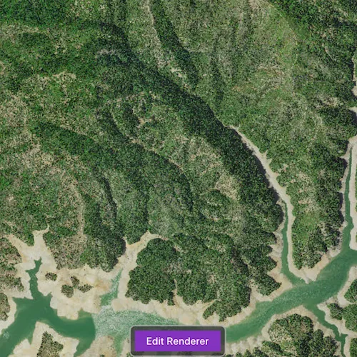
An appropriate stretch renderer can enhance the contrast of raster imagery, allowing the user to control how their data is displayed for efficient imagery analysis.
How to use the sample
Click ‘Edit Renderer’ to open the stretch renderer options. Choose one of the stretch parameter types:
- Standard deviation - a linear stretch defined by the standard deviation of the pixel values
- Min-max - a linear stretch based on minimum and maximum pixel values
- Percent clip - a linear stretch between the defined percent clip minimum and percent clip maximum pixel values
Then configure the parameters and click ‘Render’.
How it works
- Create a
Rasterfrom a raster file. - Create a
RasterLayerfrom theRaster. - Add the layer to the map.
- Create a
StretchRenderer, specifying the stretch parameters and other properties. - Set the
Rendereron theRasterLayerwithrasterLayer::setRenderer(renderer).
Relevant API
- ColorRamp
- MinMaxStretchParameters
- PercentClipStretchParameters
- Raster
- RasterLayer
- StandardDeviationStretchParameters
- StretchParameters
- StretchRenderer
Offline Data
Read more about how to set up the sample’s offline data here.
| Link | Local Location |
|---|---|
| Shasta.tif raster | <userhome>/ArcGIS/Runtime/Data/raster/Shasta.tif |
About the data
This sample uses a raster imagery tile of an area of forested mountainous terrain and rivers.
Additional information
See Stretch function in the ArcMap documentation for more information about the types of stretches that can be performed.
Tags
analysis, deviation, histogram, imagery, interpretation, min-max, percent clip, pixel, raster, stretch, symbology, visualization
Sample code
// [WriteFile Name=RasterStretchRenderer, Category=Layers]// [Legal]// Copyright 2017 Esri.//// Licensed under the Apache License, Version 2.0 (the "License");// you may not use this file except in compliance with the License.// You may obtain a copy of the License at// http://www.apache.org/licenses/LICENSE-2.0//// Unless required by applicable law or agreed to in writing, software// distributed under the License is distributed on an "AS IS" BASIS,// WITHOUT WARRANTIES OR CONDITIONS OF ANY KIND, either express or implied.// See the License for the specific language governing permissions and// limitations under the License.// [Legal]
#ifdef PCH_BUILD#include "pch.hpp"#endif // PCH_BUILD
// sample headers#include "RasterStretchRenderer.h"
// ArcGIS Maps SDK headers#include "Basemap.h"#include "Map.h"#include "MapQuickView.h"#include "MapViewTypes.h"#include "MinMaxStretchParameters.h"#include "PercentClipStretchParameters.h"#include "Raster.h"#include "RasterLayer.h"#include "StandardDeviationStretchParameters.h"#include "StretchRenderer.h"
// Qt headers#include <QStandardPaths>#include <QtCore/qglobal.h>
using namespace Esri::ArcGISRuntime;
// helper method to get cross platform data pathnamespace{  QString defaultDataPath()  {    QString dataPath;
#ifdef Q_OS_IOS    dataPath = QStandardPaths::writableLocation(QStandardPaths::DocumentsLocation);#else    dataPath = QStandardPaths::writableLocation(QStandardPaths::HomeLocation);#endif
    return dataPath;  }} // namespace
RasterStretchRenderer::RasterStretchRenderer(QQuickItem* parent /* = nullptr */) :  QQuickItem(parent),  m_dataPath(defaultDataPath() + "/ArcGIS/Runtime/Data/raster"){}
RasterStretchRenderer::~RasterStretchRenderer() = default;
void RasterStretchRenderer::init(){  // Register the map view for QML  qmlRegisterType<MapQuickView>("Esri.Samples", 1, 0, "MapView");  qmlRegisterType<RasterStretchRenderer>("Esri.Samples", 1, 0, "RasterStretchRendererSample");}
void RasterStretchRenderer::componentComplete(){  QQuickItem::componentComplete();
  // find QML MapView component  m_mapView = findChild<MapQuickView*>("mapView");  m_mapView->setWrapAroundMode(WrapAroundMode::Disabled);
  // Create the raster and raster layer  Raster* raster = new Raster(m_dataPath + "/Shasta.tif", this);  m_rasterLayer = new RasterLayer(raster, this);
  // Add the raster to the map  Basemap* basemap = new Basemap(m_rasterLayer, this);  Map* map = new Map(basemap, this);  m_mapView->setMap(map);}
//! [RasterStretchRenderer cpp set renderers]void RasterStretchRenderer::applyMinMax(double min, double max){  MinMaxStretchParameters stretchParams(QList<double>{min}, QList<double>{max});  QList<double> gammas;  bool estimateStats = true;  StretchRenderer* renderer = new StretchRenderer(stretchParams, gammas, estimateStats, PresetColorRampType::None, this);
  m_rasterLayer->setRenderer(renderer);}
void RasterStretchRenderer::applyPercentClip(double min, double max){  PercentClipStretchParameters stretchParams(min, max);  QList<double> gammas;  bool estimateStats = true;  StretchRenderer* renderer = new StretchRenderer(stretchParams, gammas, estimateStats, PresetColorRampType::None, this);
  m_rasterLayer->setRenderer(renderer);}
void RasterStretchRenderer::applyStandardDeviation(double factor){  StandardDeviationStretchParameters stretchParams(factor);  QList<double> gammas;  bool estimateStats = true;  StretchRenderer* renderer = new StretchRenderer(stretchParams, gammas, estimateStats, PresetColorRampType::None, this);
  m_rasterLayer->setRenderer(renderer);}
//! [RasterStretchRenderer cpp set renderers]
// [WriteFile Name=RasterStretchRenderer, Category=Layers]// [Legal]// Copyright 2017 Esri.//// Licensed under the Apache License, Version 2.0 (the "License");// you may not use this file except in compliance with the License.// You may obtain a copy of the License at// http://www.apache.org/licenses/LICENSE-2.0//// Unless required by applicable law or agreed to in writing, software// distributed under the License is distributed on an "AS IS" BASIS,// WITHOUT WARRANTIES OR CONDITIONS OF ANY KIND, either express or implied.// See the License for the specific language governing permissions and// limitations under the License.// [Legal]
#ifndef STRETCHRENDERER_H#define STRETCHRENDERER_H
// Qt headers#include <QQuickItem>
namespace Esri::ArcGISRuntime{ class Map; class MapQuickView; class RasterLayer;} // namespace Esri::ArcGISRuntime
class RasterStretchRenderer : public QQuickItem{ Q_OBJECT
public: explicit RasterStretchRenderer(QQuickItem* parent = nullptr); ~RasterStretchRenderer() override;
static void init();
void componentComplete() override;
Q_INVOKABLE void applyMinMax(double min, double max); Q_INVOKABLE void applyPercentClip(double min, double max); Q_INVOKABLE void applyStandardDeviation(double factor);
private: Esri::ArcGISRuntime::Map* m_map = nullptr; Esri::ArcGISRuntime::MapQuickView* m_mapView = nullptr; Esri::ArcGISRuntime::RasterLayer* m_rasterLayer = nullptr; QString m_dataPath;};
#endif // STRETCHRENDERER_H// [WriteFile Name=RasterRgbRenderer, Category=Layers]// [Legal]// Copyright 2017 Esri.//// Licensed under the Apache License, Version 2.0 (the "License");// you may not use this file except in compliance with the License.// You may obtain a copy of the License at// http://www.apache.org/licenses/LICENSE-2.0//// Unless required by applicable law or agreed to in writing, software// distributed under the License is distributed on an "AS IS" BASIS,// WITHOUT WARRANTIES OR CONDITIONS OF ANY KIND, either express or implied.// See the License for the specific language governing permissions and// limitations under the License.// [Legal]
import QtQuickimport QtQuick.Controls
Row { anchors.horizontalCenter: parent.horizontalCenter
property alias maxRange : slider.to property alias value: slider.value property alias label: text.text
Label { id: text }
Slider { id: slider width: 100 from: 0 to: maxRange
onValueChanged: { if (spinBox.value !== value) spinBox.value = value; } }
SpinBox { id: spinBox from: 0 to: slider.to
onValueChanged: { if (slider.value !== value) slider.value = value; } }}// [WriteFile Name=RasterStretchRenderer, Category=Layers]// [Legal]// Copyright 2017 Esri.//// Licensed under the Apache License, Version 2.0 (the "License");// you may not use this file except in compliance with the License.// You may obtain a copy of the License at// http://www.apache.org/licenses/LICENSE-2.0//// Unless required by applicable law or agreed to in writing, software// distributed under the License is distributed on an "AS IS" BASIS,// WITHOUT WARRANTIES OR CONDITIONS OF ANY KIND, either express or implied.// See the License for the specific language governing permissions and// limitations under the License.// [Legal]
import QtQuickimport QtQuick.Controlsimport Esri.Samples
RasterStretchRendererSample { id: rootRectangle clip: true width: 800 height: 600
readonly property string minMax: "Min Max" readonly property string percentClip: "Percent Clip" readonly property string stdDeviation: "Standard Deviation" readonly property var stretchTypes: [minMax, percentClip, stdDeviation] property bool editingRenderer: false
// add a mapView component MapView { anchors.fill: parent objectName: "mapView"
Component.onCompleted: { // Set the focus on MapView to initially enable keyboard navigation forceActiveFocus(); } }
Rectangle { visible: editButton.visible anchors.centerIn: editButton radius: 8 height: editButton.height + (16) width: editButton.width + (16) color: palette.base border.color: "darkgrey" border.width: 2 opacity: 0.75 }
Button { id: editButton anchors { bottom: parent.bottom horizontalCenter: parent.horizontalCenter margins: 32 } visible: rendererBox.width === 0 text: qsTr("Edit Renderer") onClicked: editingRenderer = true; }
Rectangle { id: rendererBox clip: true anchors { right: parent.right top: parent.top bottom: parent.bottom }
color: palette.base opacity: 0.75 width: editingRenderer ? parent.width : 0
Column { anchors { top: parent.top bottom: parent.bottom margins: 24 } width: parent.width spacing: 16
ComboBox { id: stretchTypeCombo anchors.horizontalCenter: parent.horizontalCenter model: stretchTypes property int modelWidth: 0 width: modelWidth + leftPadding + rightPadding + (indicator ? indicator.width : 10) Component.onCompleted : { for (let i = 0; i < model.length; ++i) { metrics.text = model[i]; modelWidth = Math.max(modelWidth, metrics.width); } }
TextMetrics { id: metrics font: stretchTypeCombo.font } }
InputWithLabel { id: minMaxMin visible: stretchTypeCombo.currentText === minMax spacing: 8 label: qsTr("min value") maxRange: 255 value: 0 }
InputWithLabel { id: minMaxMax visible: stretchTypeCombo.currentText === minMax spacing: 8 label: qsTr("max value") maxRange: 255 value: 255 }
InputWithLabel { id: percentClipMin visible: stretchTypeCombo.currentText === percentClip spacing: 8 label: qsTr("min value") maxRange: 100 value: 0 }
InputWithLabel { id: percentClipMax visible: stretchTypeCombo.currentText === percentClip spacing: 8 label: qsTr("max value") maxRange: 100 value: 100 }
InputWithLabel { id: sdFactor visible: stretchTypeCombo.currentText === stdDeviation spacing: 8 label: qsTr("factor") maxRange: 25 value: 0 }
Button { text: qsTr("Render") anchors.horizontalCenter: parent.horizontalCenter onClicked: { editingRenderer = false; applyRendererSettings(); } } }
Behavior on width { PropertyAnimation { duration: 500 } } }
function applyRendererSettings(){ if (stretchTypeCombo.currentText === minMax){ applyMinMax(minMaxMin.value, minMaxMax.value); } else if (stretchTypeCombo.currentText === percentClip){ applyPercentClip(percentClipMin.value, 100 - percentClipMax.value); } else if (stretchTypeCombo.currentText === stdDeviation){ applyStandardDeviation(sdFactor.value); } }}