Create a raster layer from a raster image service.
Use case
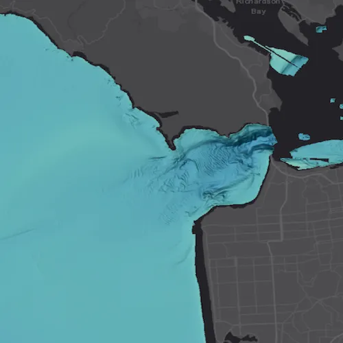
Accessing a raster image from an online service can be useful for analysing the most up-to-date data available for an area. For example, retrieving recent results of bathymetry surveys within a shipping channel monitored for its sediment build-up would allow planners to assess dredging needs.
How to use the sample
Simply launch the sample to see a raster from an image service being used on a map.
How it works
- Create an
ImageServiceRasterusing the service’s URL. - Create a
RasterLayerfrom the image service raster. - Add the raster layer the the map.
Relevant API
- ImageServiceRaster
- RasterLayer
About the data
This sample uses a NOAA raster image service. The service computes a hillshade image from the depth (in meters) of U.S. coastal waters.
Tags
image service, raster
Sample code
// [WriteFile Name=RasterLayerService, Category=Layers]// [Legal]// Copyright 2017 Esri.//// Licensed under the Apache License, Version 2.0 (the "License");// you may not use this file except in compliance with the License.// You may obtain a copy of the License at// http://www.apache.org/licenses/LICENSE-2.0//// Unless required by applicable law or agreed to in writing, software// distributed under the License is distributed on an "AS IS" BASIS,// WITHOUT WARRANTIES OR CONDITIONS OF ANY KIND, either express or implied.// See the License for the specific language governing permissions and// limitations under the License.// [Legal]
#ifdef PCH_BUILD#include "pch.hpp"#endif // PCH_BUILD
// sample headers#include "RasterLayerService.h"
// ArcGIS Maps SDK headers#include "ArcGISTiledLayer.h"#include "Basemap.h"#include "Error.h"#include "ImageServiceRaster.h"#include "LayerListModel.h"#include "Map.h"#include "MapQuickView.h"#include "MapTypes.h"#include "MapViewTypes.h"#include "Point.h"#include "RasterLayer.h"#include "SpatialReference.h"#include "Viewpoint.h"
// Qt headers#include <QFuture>
using namespace Esri::ArcGISRuntime;
RasterLayerService::RasterLayerService(QQuickItem* parent /* = nullptr */) :  QQuickItem(parent){}
RasterLayerService::~RasterLayerService() = default;
void RasterLayerService::init(){  // Register the map view for QML  qmlRegisterType<MapQuickView>("Esri.Samples", 1, 0, "MapView");  qmlRegisterType<RasterLayerService>("Esri.Samples", 1, 0, "RasterLayerServiceSample");}
void RasterLayerService::componentComplete(){  QQuickItem::componentComplete();
  // find QML MapView component  m_mapView = findChild<MapQuickView*>("mapView");  m_mapView->setWrapAroundMode(WrapAroundMode::Disabled);
  // Create a map using the dark gray basemap  m_map = new Map(BasemapStyle::ArcGISDarkGray, this);  m_mapView->setMap(m_map);
  //! [ImageServiceRaster Create a new image service raster]  // create an image service raster  ImageServiceRaster* imageServiceRaster =    new ImageServiceRaster(QUrl(QStringLiteral("https://gis.ngdc.noaa.gov/arcgis/rest/services/bag_hillshades_subsets/ImageServer")), this);  // zoom to the center of the raster once it's loaded  connect(imageServiceRaster, &ImageServiceRaster::doneLoading, this, [this]()  {    constexpr double scale = 200000.;    Viewpoint vpCenter = Viewpoint(Point(-13643095.660131, 4550009.846004, SpatialReference::webMercator()), scale);    m_mapView->setViewpointAsync(vpCenter);  });
  // create a raster layer using the image service raster  m_rasterLayer = new RasterLayer(imageServiceRaster, this);  // add the raster layer to the map's operational layers  m_map->operationalLayers()->append(m_rasterLayer);  //! [ImageServiceRaster Create a new image service raster]}
// [WriteFile Name=RasterLayerService, Category=Layers]// [Legal]// Copyright 2017 Esri.//// Licensed under the Apache License, Version 2.0 (the "License");// you may not use this file except in compliance with the License.// You may obtain a copy of the License at// http://www.apache.org/licenses/LICENSE-2.0//// Unless required by applicable law or agreed to in writing, software// distributed under the License is distributed on an "AS IS" BASIS,// WITHOUT WARRANTIES OR CONDITIONS OF ANY KIND, either express or implied.// See the License for the specific language governing permissions and// limitations under the License.// [Legal]
#ifndef RASTERLAYERSERVICE_H#define RASTERLAYERSERVICE_H
// Qt headers#include <QQuickItem>
namespace Esri::ArcGISRuntime{ class Basemap; class Map; class MapQuickView; class RasterLayer;} // namespace Esri::ArcGISRuntime
class RasterLayerService : public QQuickItem{ Q_OBJECT
public: explicit RasterLayerService(QQuickItem* parent = nullptr); ~RasterLayerService() override;
static void init();
void componentComplete() override;
private: Esri::ArcGISRuntime::Map* m_map = nullptr; Esri::ArcGISRuntime::MapQuickView* m_mapView = nullptr; Esri::ArcGISRuntime::RasterLayer* m_rasterLayer = nullptr;};
#endif // RASTERLAYERSERVICE_H// [WriteFile Name=RasterLayerService, Category=Layers]// [Legal]// Copyright 2017 Esri.//// Licensed under the Apache License, Version 2.0 (the "License");// you may not use this file except in compliance with the License.// You may obtain a copy of the License at// http://www.apache.org/licenses/LICENSE-2.0//// Unless required by applicable law or agreed to in writing, software// distributed under the License is distributed on an "AS IS" BASIS,// WITHOUT WARRANTIES OR CONDITIONS OF ANY KIND, either express or implied.// See the License for the specific language governing permissions and// limitations under the License.// [Legal]
import QtQuickimport QtQuick.Controlsimport Esri.Samples
RasterLayerServiceSample { id: rootRectangle clip: true
width: 800 height: 600
// add a mapView component MapView { anchors.fill: parent objectName: "mapView"
Component.onCompleted: { // Set the focus on MapView to initially enable keyboard navigation forceActiveFocus(); } }}