Vertically exaggerate terrain in a scene.
Use case
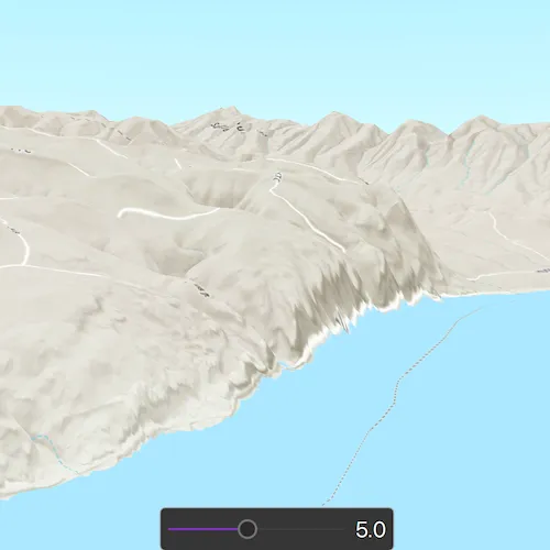
Vertical exaggeration can be used to emphasize subtle changes in a surface. This can be useful in creating visualizations of terrain where the horizontal extent of the surface is significantly greater than the amount of vertical change in the surface. A fractional vertical exaggeration can be used to flatten surfaces or features that have extreme vertical variation.
How to use the sample
Use the slider to update terrain exaggeration.
How it works
- Create an elevation source and add it to a new surface.
- An elevation source defines the terrain based on a digital elevation model (DEM) or digital terrain model (DTM).
- Add the surface.
- The surface visualizes the elevation source.
- Configure the surface’s elevation exaggeration using
Surface::setElevationExaggeration.
Relevant API
- Scene
- Scene::baseSurface
- Surface
- Surface::elevationExaggeration
Tags
3D, DEM, DTM, elevation, scene, surface, terrain
Sample code
// [WriteFile Name=TerrainExaggeration, Category=Scenes]// [Legal]// Copyright 2018 Esri.//// Licensed under the Apache License, Version 2.0 (the "License");// you may not use this file except in compliance with the License.// You may obtain a copy of the License at// http://www.apache.org/licenses/LICENSE-2.0//// Unless required by applicable law or agreed to in writing, software// distributed under the License is distributed on an "AS IS" BASIS,// WITHOUT WARRANTIES OR CONDITIONS OF ANY KIND, either express or implied.// See the License for the specific language governing permissions and// limitations under the License.// [Legal]
#ifdef PCH_BUILD#include "pch.hpp"#endif // PCH_BUILD
// sample headers#include "TerrainExaggeration.h"
// ArcGIS Maps SDK headers#include "ArcGISTiledElevationSource.h"#include "Camera.h"#include "ElevationSourceListModel.h"#include "MapTypes.h"#include "Point.h"#include "Scene.h"#include "SceneQuickView.h"#include "SpatialReference.h"#include "Surface.h"
// Qt headers#include <QFuture>
using namespace Esri::ArcGISRuntime;
TerrainExaggeration::TerrainExaggeration(QQuickItem* parent /* = nullptr */) :  QQuickItem(parent){}
void TerrainExaggeration::init(){  // Register classes for QML  qmlRegisterType<SceneQuickView>("Esri.Samples", 1, 0, "SceneView");  qmlRegisterType<TerrainExaggeration>("Esri.Samples", 1, 0, "TerrainExaggerationSample");}
void TerrainExaggeration::componentComplete(){  QQuickItem::componentComplete();
  // Create a scene and give it to the SceneView  m_sceneView = findChild<SceneQuickView*>("sceneView");  Scene* scene = new Scene(BasemapStyle::ArcGISTopographic, this);  m_surface = new Surface(this);  m_surface->elevationSources()->append(    new ArcGISTiledElevationSource(QUrl("https://elevation3d.arcgis.com/arcgis/rest/services/WorldElevation3D/Terrain3D/ImageServer"), this));
  // Create the camera object at our initial viewpoint  const Point initialPoint(-119.9616962169934, 46.7000413426849, 3183, SpatialReference(4326));  const Camera initialViewpointCamera(initialPoint, 0, 7, 70, 0);
  // Set the initial ViewpointCamera for the scene  m_sceneView->setViewpointCameraAsync(initialViewpointCamera);
  // Initialize the sceneview by applying the surface  scene->setBaseSurface(m_surface);  m_sceneView->setArcGISScene(scene);}
void TerrainExaggeration::setElevationExaggeration(double factor){  // If the surface exists, trigger a change in elevation exaggeration by [factor] amount  if (m_surface)  {    m_surface->setElevationExaggeration(factor);  }}
// [WriteFile Name=TerrainExaggeration, Category=Scenes]// [Legal]// Copyright 2018 Esri.//// Licensed under the Apache License, Version 2.0 (the "License");// you may not use this file except in compliance with the License.// You may obtain a copy of the License at// http://www.apache.org/licenses/LICENSE-2.0//// Unless required by applicable law or agreed to in writing, software// distributed under the License is distributed on an "AS IS" BASIS,// WITHOUT WARRANTIES OR CONDITIONS OF ANY KIND, either express or implied.// See the License for the specific language governing permissions and// limitations under the License.// [Legal]
#ifndef TERRAINEXAGGERATION_H#define TERRAINEXAGGERATION_H
// Qt headers#include <QQuickItem>
namespace Esri::ArcGISRuntime{ class SceneQuickView; class Surface;} // namespace Esri::ArcGISRuntime
class TerrainExaggeration : public QQuickItem{ Q_OBJECT
public: explicit TerrainExaggeration(QQuickItem* parent = nullptr); ~TerrainExaggeration() override = default;
void componentComplete() override; static void init(); Q_INVOKABLE void setElevationExaggeration(double factor);
private: Esri::ArcGISRuntime::SceneQuickView* m_sceneView = nullptr; Esri::ArcGISRuntime::Surface* m_surface = nullptr;};
#endif // TERRAINEXAGGERATION_H// [WriteFile Name=TerrainExaggeration, Category=Scenes]// [Legal]// Copyright 2018 Esri.//// Licensed under the Apache License, Version 2.0 (the "License");// you may not use this file except in compliance with the License.// You may obtain a copy of the License at// http://www.apache.org/licenses/LICENSE-2.0//// Unless required by applicable law or agreed to in writing, software// distributed under the License is distributed on an "AS IS" BASIS,// WITHOUT WARRANTIES OR CONDITIONS OF ANY KIND, either express or implied.// See the License for the specific language governing permissions and// limitations under the License.// [Legal]
import QtQuickimport QtQuick.Controlsimport Esri.Samples
TerrainExaggerationSample { id: terrainExaggerationSample clip: true width: 800 height: 600
SceneView { id: sceneView anchors.fill: parent objectName: "sceneView"
Component.onCompleted: { // Set the focus on SceneView to initially enable keyboard navigation forceActiveFocus(); }
// Slider UI presentation at bottom Rectangle { anchors { horizontalCenter: parent.horizontalCenter bottom: sceneView.attributionTop }
width: childrenRect.width height: childrenRect.height radius: 5 color: palette.base
border { width: 1 color: "darkgrey" }
MouseArea { anchors.fill: parent acceptedButtons: Qt.LeftButton | Qt.RightButton onClicked: mouse => mouse.accepted = true onDoubleClicked: mouse => mouse.accepted = true onWheel: wheel => wheel.accepted = true }
// sliderCombo: A slider and text for its value Row { id: sliderCombo spacing: 10 padding: 8
Slider { id: slider anchors { verticalCenter: parent.verticalCenter } // Slider controls degrees of rotation from: 1 to: 10 onValueChanged: { terrainExaggerationSample.setElevationExaggeration(slider.value); } }
Label { anchors { verticalCenter: parent.verticalCenter margins: 5 } horizontalAlignment: TextInput.AlignHCenter font.pixelSize: 20 text: slider.value.toPrecision(2); } } } }}