Demonstrates the workflow of getting the network state and validating the topology of a utility network.
Use case
Dirty areas are generated where edits to utility network features have not been evaluated against the network rules. Tracing across this area could result in an error or return inaccurate results. Validating the utility network updates the network topology with the edited feature data, maintaining consistency between the features and topology. Querying the network state allows you to determine if there are dirty areas or errors in a utility network, and if it supports network topology.
How to use the sample
Select features to make edits and then use ‘Update and Apply Edit’ to send edits to the server.
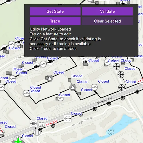
- Click ‘Get state’ to check if validate is required or if tracing is available.
- Click ‘Validate’ to validate network topology and clear dirty areas.
- Click ‘Trace’ to run a trace.
How it works
- Create and load a
Mapwith a web map item URL. - Load the
UtilityNetworkfrom the web map and switch itsServiceGeodatabaseto a new branch version. - Add
LabelDefinitions for the fields that will be updated on a feature edit. - Add the
UtilityNetwork.dirtyAreaTableto the map to visualize dirty areas or errors. - Set a default starting location and trace parameters to stop traversability on an open device.
- Get the
UtilityNetworkCapabilitiesfrom theUtilityNetworkDefinitionand use these values to enable or disable the ‘Get State’, ‘Validate’, and ‘Trace’ buttons. - When an
ArcGISFeatureis selected for editing, populate the choice list for the field value using the field’sCodedValueDomain.codedValues. - When ‘Update and Apply Edits’ is clicked, update the value of the selected feature’s attribute value with the selected
CodedValue.codeand callServiceGeodatabase.applyEditsAsync(). - When ‘Get State’ is clicked, call
UtilityNetwork.getStateAsync()and print the results. - When ‘Validate’ is clicked, get the current map extent and call
UtilityNetwork.validateNetworkTopology(). - When ‘Trace’ is clicked, call
UtilityNetwork.traceAsync()with the predefined parameters and select all features returned. - When ‘Clear Selection’ or ‘Cancel’ are clicked, clear all selected features on each layer in the map and close the attribute picker.
Relevant API
- UtilityElement
- UtilityElementTraceResult
- UtilityNetwork
- UtilityNetworkCapabilities
- UtilityNetworkState
- UtilityNetworkValidationJob
- UtilityTraceConfiguration
- UtilityTraceParameters
- UtilityTraceResult
About the data
The Naperville electric feature service contains a utility network that can be used to query the network state and validate network topology before tracing. The Naperville electric webmap uses the same feature service endpoint and is shown in this sample. Authentication is required and handled within the sample code.
Tags
dirty areas, edit, network topology, online, state, trace, utility network, validate
Sample code
// [WriteFile Name=ValidateUtilityNetworkTopology, Category=UtilityNetwork]// [Legal]// Copyright 2024 Esri.//// Licensed under the Apache License, Version 2.0 (the "License");// you may not use this file except in compliance with the License.// You may obtain a copy of the License at// http://www.apache.org/licenses/LICENSE-2.0//// Unless required by applicable law or agreed to in writing, software// distributed under the License is distributed on an "AS IS" BASIS,// WITHOUT WARRANTIES OR CONDITIONS OF ANY KIND, either express or implied.// See the License for the specific language governing permissions and// limitations under the License.// [Legal]
#ifdef PCH_BUILD#include "pch.hpp"#endif // PCH_BUILD
// sample headers#include "ValidateUtilityNetworkTopology.h"
// ArcGIS Maps SDK headers#include "ArcGISFeature.h"#include "ArcGISFeatureListModel.h"#include "ArcGISRuntimeEnvironment.h"#include "AttributeListModel.h"#include "Authentication/AuthenticationManager.h"#include "Authentication/ArcGISAuthenticationChallenge.h"#include "Authentication/TokenCredential.h"#include "Envelope.h"#include "Error.h"#include "ErrorException.h"#include "FeatureEditResult.h"#include "FeatureLayer.h"#include "FeatureQueryResult.h"#include "FeatureTableEditResult.h"#include "Field.h"#include "Graphic.h"#include "GraphicListModel.h"#include "GraphicsOverlay.h"#include "GraphicsOverlayListModel.h"#include "LabelDefinition.h"#include "LabelDefinitionListModel.h"#include "LayerListModel.h"#include "LoadSettings.h"#include "Map.h"#include "MapQuickView.h"#include "MapTypes.h"#include "Point.h"#include "Portal.h"#include "PortalItem.h"#include "QueryParameters.h"#include "ServiceFeatureTable.h"#include "ServiceGeodatabase.h"#include "ServiceVersionInfo.h"#include "ServiceVersionParameters.h"#include "SimpleLabelExpression.h"#include "SimpleMarkerSymbol.h"#include "SpatialReference.h"#include "SymbolTypes.h"#include "TaskTypes.h"#include "TextSymbol.h"#include "UtilityAssetGroup.h"#include "UtilityAssetType.h"#include "UtilityDomainNetwork.h"#include "UtilityElement.h"#include "UtilityElementTraceResult.h"#include "UtilityNetwork.h"#include "UtilityNetworkCapabilities.h"#include "UtilityNetworkDefinition.h"#include "UtilityNetworkListModel.h"#include "UtilityNetworkSource.h"#include "UtilityNetworkState.h"#include "UtilityNetworkTypes.h"#include "UtilityNetworkValidationJob.h"#include "UtilityTerminal.h"#include "UtilityTerminalConfiguration.h"#include "UtilityTier.h"#include "UtilityTraceParameters.h"#include "UtilityTraceResultListModel.h"#include "UtilityValidationResult.h"#include "Viewpoint.h"
// Qt headers#include <QFuture>#include <QUuid>
using namespace Esri::ArcGISRuntime;using namespace Esri::ArcGISRuntime::Authentication;
ValidateUtilityNetworkTopology::ValidateUtilityNetworkTopology(QObject* parent /* = nullptr */) :  ArcGISAuthenticationChallengeHandler(parent){  ArcGISRuntimeEnvironment::authenticationManager()->setArcGISAuthenticationChallengeHandler(this);
  Portal* portal = new Portal(QUrl("https://sampleserver7.arcgisonline.com/portal/sharing/rest"), this);
  PortalItem* portalItem = new PortalItem(portal, "6e3fc6db3d0b4e6589eb4097eb3e5b9b", this);
  m_map = new Map(portalItem, this);
  connect(m_map, &Map::doneLoading, this, [this]()  {    onMapLoaded();  });}
ValidateUtilityNetworkTopology::~ValidateUtilityNetworkTopology() = default;
void ValidateUtilityNetworkTopology::init(){  // Register the map view for QML  qmlRegisterType<MapQuickView>("Esri.Samples", 1, 0, "MapView");  qmlRegisterType<ValidateUtilityNetworkTopology>("Esri.Samples", 1, 0, "ValidateUtilityNetworkTopologySample");}
MapQuickView* ValidateUtilityNetworkTopology::mapView() const{  return m_mapView;}
// Set the view (created in QML)void ValidateUtilityNetworkTopology::setMapView(MapQuickView* mapView){  if (!mapView || mapView == m_mapView)  {    return;  }
  m_progressBarVisibility = true;  emit progressBarVisibilityChanged();  updateMessage("Loading a webmap...");
  const Envelope envelope(-9815489.0660101417, 5128463.4221229386, -9814625.2768726498, 5128968.4911854975, SpatialReference::webMercator());
  Viewpoint initialViewpoint(envelope);
  m_map->setInitialViewpoint(initialViewpoint);
  // Load in persistent session mode (workaround for server caching issue)  // https://support.esri.com/en-us/bug/asynchronous-validate-request-for-utility-network-servi-bug-000160443  m_map->loadSettings()->setFeatureServiceSessionType(FeatureServiceSessionType::Persistent);
  m_mapView = mapView;  m_mapView->setMap(m_map);
  GraphicsOverlay* overlay = new GraphicsOverlay(this);  m_mapView->graphicsOverlays()->append(overlay);
  emit mapViewChanged();
  connectSignals();}
void ValidateUtilityNetworkTopology::onMapLoaded(){  // Load and switch utility network version  updateMessage("Loading the utility network...");
  m_utilityNetwork = m_map->utilityNetworks()->first();
  const QString randomVersionUuid = QUuid().createUuid().toString(QUuid::WithoutBraces);
  // Restrict editing and tracing on a random branch  ServiceVersionParameters* params = new ServiceVersionParameters(this);  params->setName("ValidateNetworkTopology_" + randomVersionUuid);  params->setAccess(VersionAccess::Private);  params->setDescription("Validate network topology with ArcGIS Runtime");
  connect(m_utilityNetwork, &UtilityNetwork::doneLoading, this, [this]()  {    setupTraceParameters();  });
  m_utilityNetwork->load();  m_serviceGeodatabase = m_utilityNetwork->serviceGeodatabase();
  connect(m_serviceGeodatabase, &ServiceGeodatabase::doneLoading, this, [this, params](const Esri::ArcGISRuntime::Error& loadError)  {    onServiceGeodatabaseLoaded(params, loadError);  });
  m_serviceGeodatabase->load();}
void ValidateUtilityNetworkTopology::onServiceGeodatabaseLoaded(ServiceVersionParameters* params, const Error& loadError){  if (!loadError.isEmpty())  {    return;  }
  m_serviceGeodatabase->createVersionAsync(params).then(this, [this](ServiceVersionInfo* serviceVersionInfo)  {    m_serviceGeodatabase->switchVersionAsync(serviceVersionInfo->name())      .then(this, [this]()    {      displayLabelDefinitions();
      // Visualize dirty area by adding to the map      ArcGISFeatureTable* dirtyAreaTable = m_utilityNetwork->dirtyAreaTable();      m_map->operationalLayers()->append(new FeatureLayer(dynamic_cast<FeatureTable*>(dirtyAreaTable), this));    });    serviceVersionInfo->deleteLater();  });}
void ValidateUtilityNetworkTopology::connectSignals(){  connect(m_mapView, &MapQuickView::mouseClicked, this, [this](QMouseEvent& mouseEvent)  {    if (m_deviceFeatureLayer && m_lineFeatureLayer)    {      // first clear the selection      m_deviceFeatureLayer->clearSelection();      m_lineFeatureLayer->clearSelection();
      m_progressBarVisibility = true;      emit progressBarVisibilityChanged();
      updateMessage("Identifying feature to edit...");
      if (m_map->loadStatus() != LoadStatus::Loaded)      {        return;      }
      // Perform an identify to determine if a user tapped on a feature.      m_mapView->identifyLayersAsync(mouseEvent.position(), 5.0, false)        .then(this, [this](const QList<IdentifyLayerResult*>& results)      {        onIdentifyLayersAsyncCompleted(results);      });    }  });}
void ValidateUtilityNetworkTopology::onIdentifyLayersAsyncCompleted(const QList<IdentifyLayerResult*>& results){  if (!results.isEmpty())  {    for (IdentifyLayerResult* result : results)    {      if (result &&          (result->layerContent()->name() == "Electric Distribution Device" || result->layerContent()->name() == "Electric Distribution Line"))      {        m_feature = static_cast<ArcGISFeature*>(std::as_const(result)->geoElements().first());        break;      }    }  }  else  {    updateMessage("No feature identified. Tap on a feature to edit.");
    m_progressBarVisibility = false;    emit progressBarVisibilityChanged();
    return;  }  m_fieldName = m_feature->featureTable()->tableName() == "Electric Distribution Device" ? "devicestatus" : "nominalvoltage";  Field field = m_feature->featureTable()->field(m_fieldName);  CodedValueDomain codedValueDomain = static_cast<CodedValueDomain>(field.domain());  m_codedValues = codedValueDomain.codedValues();  if (field.isEmpty() || m_codedValues.empty())  {    return;  }
  if (m_feature->loadStatus() != LoadStatus::Loaded)  {    m_feature->load();  }
  m_featureToEdit = m_feature;
  // Select the feature.  if (m_fieldName == "nominalvoltage")  {    m_lineFeatureLayer->selectFeature(m_featureToEdit);  }  else if (m_fieldName == "devicestatus")  {    m_deviceFeatureLayer->selectFeature(m_featureToEdit);  }
  m_choices.clear();
  m_choices.append("");  for (const CodedValue& codedValue : m_codedValues)  {    if (codedValue.code() == m_featureToEdit->attributes()->attributeValue(m_fieldName))    {      m_choices.replace(0, codedValue.name());    }    else    {      m_choices.append(codedValue.name());    }  }  emit choicesChanged();
  updateMessage("Select a new " + m_fieldName);
  m_clearButtonAvailability = true;  emit clearButtonAvailabilityChanged();
  m_updateWindowVisibility = true;  emit updateWindowVisibilityChanged();
  m_progressBarVisibility = false;  emit progressBarVisibilityChanged();
  emit fieldNameChanged();}
void ValidateUtilityNetworkTopology::onApplyEdits(const QString& choice){  CodedValue choiceCodeValue;
  m_serviceGeodatabase = static_cast<ServiceFeatureTable*>(m_featureToEdit->featureTable())->serviceGeodatabase();
  m_progressBarVisibility = true;  emit progressBarVisibilityChanged();
  for (const CodedValue& codedValue : m_codedValues)  {    if (codedValue.name() == choice)    {      choiceCodeValue = codedValue;    }  }
  m_featureToEdit->attributes()->replaceAttribute(m_fieldName, choiceCodeValue.code());
  updateMessage("Updating feature...");
  m_featureToEdit->featureTable()    ->updateFeatureAsync(m_featureToEdit)    .then(this, [this]()  {    updateMessage("Applying edits...");    m_serviceGeodatabase->applyEditsAsync()      .then(this,            [this](const QList<FeatureTableEditResult*>& featureTableEditResults)    {      for (FeatureTableEditResult* featureTableEditResult : featureTableEditResults)      {        const auto results = featureTableEditResult->editResults();        for (FeatureEditResult* featureEditResult : results)        {          if (!featureEditResult->error().isEmpty())          {            updateMessage("Apply edits completed with error.");            return;          }          else          {            updateMessage("Apply edits completed successfully.\n"                          "Click 'Get State' to check the updated network state.");          }        }      }
      m_progressBarVisibility = false;      emit progressBarVisibilityChanged();    })      .onFailed(this, [this]()    {      updateMessage("Apply edits failed.");
      m_progressBarVisibility = false;      emit progressBarVisibilityChanged();    });  });
  m_deviceFeatureLayer->clearSelection();  m_lineFeatureLayer->clearSelection();
  m_updateWindowVisibility = false;  emit updateWindowVisibilityChanged();
  m_validateButtonAvailability = true;  emit validateButtonAvailabilityChanged();
  m_clearButtonAvailability = false;  emit clearButtonAvailabilityChanged();}
void ValidateUtilityNetworkTopology::onClear(){  // Clear the selection.  m_deviceFeatureLayer->clearSelection();  m_lineFeatureLayer->clearSelection();
  m_updateWindowVisibility = false;  emit updateWindowVisibilityChanged();
  m_featureToEdit = nullptr;
  updateMessage("Selection cleared.");
  m_clearButtonAvailability = false;  emit clearButtonAvailabilityChanged();}
void ValidateUtilityNetworkTopology::onGetState(){  m_utilityNetwork = m_mapView ? (m_mapView->map() ? m_mapView->map()->utilityNetworks()->first() : nullptr) : nullptr;
  if (m_utilityNetwork && m_utilityNetwork->definition()->capabilities()->isSupportsNetworkState())  {    m_progressBarVisibility = true;    emit progressBarVisibilityChanged();
    updateMessage("Getting utility network state...");
    m_utilityNetwork->stateAsync().then(this, [this](const QFuture<Esri::ArcGISRuntime::UtilityNetworkState*>& state)    {      m_utilityNetworkstate = state.result();
      // Validate if dirty areas or errors exist      m_validateButtonAvailability = m_utilityNetworkstate->hasDirtyAreas();      emit validateButtonAvailabilityChanged();
      // Trace if network topology is enabled      m_traceButtonAvailability = m_utilityNetworkstate->isNetworkTopologyEnabled();      emit traceButtonAvailabilityChanged();
      m_message = QString("Utility Network State:\n"                          "    Has Dirty Areas: " +                          QString(m_utilityNetworkstate && m_utilityNetworkstate->hasDirtyAreas() ? "true" : "false") +                          "\n"                          "    Has Errors: " +                          QString(m_utilityNetworkstate && m_utilityNetworkstate->hasErrors() ? "true" : "false") +                          "\n"                          "    Is Network Topology Enabled: " +                          QString(m_utilityNetworkstate && m_utilityNetworkstate->isNetworkTopologyEnabled() ? "true" : "false") + "\n");
      if (m_utilityNetworkstate->hasDirtyAreas() || m_utilityNetworkstate->hasErrors())      {        m_message.append("Click 'Validate' before trace or expect a trace error.");      }      else      {        m_message.append("Tap on a feature to edit or click 'Trace' to run a trace.");      }
      updateMessage(m_message);
      m_utilityNetworkstate->deleteLater();
      m_progressBarVisibility = false;      emit progressBarVisibilityChanged();    });  }}
void ValidateUtilityNetworkTopology::onValidate(){  m_utilityNetwork = m_mapView ? (m_mapView->map() ? m_mapView->map()->utilityNetworks()->first() : nullptr) : nullptr;
  if (m_utilityNetwork)  {    // Validate using the current extent    const Envelope extent = m_mapView->currentViewpoint(ViewpointType::BoundingGeometry).targetGeometry().extent();
    m_progressBarVisibility = true;    emit progressBarVisibilityChanged();
    updateMessage("Validating utility network topology...");
    // Get the validation result    UtilityNetworkValidationJob* job = m_utilityNetwork->validateNetworkTopology(extent);
    connect(job, &UtilityNetworkValidationJob::statusChanged, this, [this, job](JobStatus status)    {      if (status == JobStatus::Succeeded)      {        UtilityValidationResult* result = job->result();        result->hasDirtyAreas();        result->hasErrors();
        updateMessage("Utility Validation Result:\n"                      "    Has Dirty Areas: " +                      QString(result->hasDirtyAreas() ? "true" : "false") +                      "\n"                      "    Has Errors: " +                      QString(result->hasErrors() ? "true" : "false") +                      "\n"                      "    Click 'Get State' to check the updated network state.");
        m_validateButtonAvailability = result->hasDirtyAreas();        emit validateButtonAvailabilityChanged();
        m_progressBarVisibility = false;        emit progressBarVisibilityChanged();
        job->deleteLater();      }      else if (status == JobStatus::Failed)      {        updateMessage("Validate network topology failed.");
        m_progressBarVisibility = false;        emit progressBarVisibilityChanged();
        job->deleteLater();      }      else if (status == JobStatus::Canceling)      {        updateMessage("Validate network topology cancelled.");
        m_progressBarVisibility = false;        emit progressBarVisibilityChanged();
        job->deleteLater();      }    });    job->start();  }}
void ValidateUtilityNetworkTopology::onTrace(){  m_utilityNetwork = m_mapView ? (m_mapView->map() ? m_mapView->map()->utilityNetworks()->first() : nullptr) : nullptr;
  if (m_utilityNetwork)  {    updateMessage("Running a downstream trace...");
    m_progressBarVisibility = true;    emit progressBarVisibilityChanged();
    // Clear previous selection from the layers.    m_deviceFeatureLayer->clearSelection();    m_lineFeatureLayer->clearSelection();
    //  Get the trace result from the utility network.    m_utilityNetwork->traceAsync(m_traceParameters)      .then(this,            [this](QList<UtilityTraceResult*>)    {      m_progressBarVisibility = false;      emit progressBarVisibilityChanged();
      UtilityTraceResult* result = m_utilityNetwork->traceResult()->at(0);
      const QList<UtilityElement*> elements = static_cast<UtilityElementTraceResult*>(result)->elements(this);      updateMessage(QString("Trace completed: %1 elements found.").arg(elements.length()));
      QueryParameters deviceParams;      QueryParameters lineParams;      QList<qint64> deviceObjIds;      QList<qint64> lineObjIds;
      for (UtilityElement* item : elements)      {        if (item->networkSource()->name() == "Electric Distribution Device")        {          deviceObjIds.append(item->objectId());        }        else if (item->networkSource()->name() == "Electric Distribution Line")        {          lineObjIds.append(item->objectId());        }      }
      deviceParams.setObjectIds(deviceObjIds);      lineParams.setObjectIds(lineObjIds);
      m_deviceFeatureLayer->selectFeaturesAsync(deviceParams, SelectionMode::Add)        .then(this, [](FeatureQueryResult* rawResult)      {        std::unique_ptr<FeatureQueryResult>{rawResult};      });      m_lineFeatureLayer->selectFeaturesAsync(lineParams, SelectionMode::Add)        .then(this, [this](FeatureQueryResult* rawResult)      {        std::unique_ptr<FeatureQueryResult>{rawResult};
        m_clearButtonAvailability = true;        emit clearButtonAvailabilityChanged();      });      result->deleteLater();    })      .onFailed(this, [this]()    {      updateMessage("Trace failed.\n"                    "Click 'Get State' to check the updated network state.");
      m_progressBarVisibility = false;      emit progressBarVisibilityChanged();    });  }}
void ValidateUtilityNetworkTopology::updateMessage(QString message){  m_message = message;  emit messageChanged();}
void ValidateUtilityNetworkTopology::displayLabelDefinitions(){  FeatureLayer* featureLayer;  // Visualize attribute editing using labels  LabelDefinition* m_deviceLabelDefinition = createDeviceLabelDefinition();  LabelDefinition* m_lineLabelDefinition = createLineLabelDefinition();  LayerListModel* layers = m_mapView->map()->operationalLayers();
  for (Layer* layer : *layers)  {    if (layer->layerType() == LayerType::FeatureLayer)    {      featureLayer = qobject_cast<FeatureLayer*>(layer);
      if (featureLayer->name() == "Electric Distribution Device")      {        m_deviceFeatureLayer = featureLayer;        m_deviceFeatureLayer->labelDefinitions()->append(m_deviceLabelDefinition);        m_deviceFeatureLayer->setLabelsEnabled(true);      }      else if (featureLayer->name() == "Electric Distribution Line")      {        m_lineFeatureLayer = featureLayer;        m_lineFeatureLayer->labelDefinitions()->append(m_lineLabelDefinition);        m_lineFeatureLayer->setLabelsEnabled(true);      }    }  }}
void ValidateUtilityNetworkTopology::setupTraceParameters(){  // Trace with a subnetwork controller as default starting location  m_utilityAssetType =    m_utilityNetwork ?      m_utilityNetwork->definition()->networkSource("Electric Distribution Device")->assetGroup("Circuit Breaker")->assetType("Three Phase") :      nullptr;
  if (m_utilityAssetType)  {    const QList<UtilityTerminal*> utilityTerminals = m_utilityAssetType->terminalConfiguration()->terminals();
    UtilityTerminal* loadTerminal = nullptr;
    for (UtilityTerminal* utilityTerminal : utilityTerminals)    {      // Set the terminal for the location. (For our case, use the "Load" terminal.)      if (utilityTerminal->name() == "Load")      {        loadTerminal = utilityTerminal;        break;      }    }    m_startingLocation =      m_utilityNetwork->createElementWithAssetType(m_utilityAssetType, QUuid("{1CAF7740-0BF4-4113-8DB2-654E18800028}"), loadTerminal, this);  }  else  {    return;  }
  // Display starting location as graphic  m_utilityNetwork->featuresForElementsAsync(QList<UtilityElement*>{m_startingLocation})    .then(this, [this](QList<ArcGISFeature*>)  {    ArcGISFeatureListModel* elementFeaturesList = m_utilityNetwork->featuresForElementsResult();    const Point startingLocationGeometry = geometry_cast<Point>(elementFeaturesList->first()->geometry());
    GraphicsOverlay* overlay = new GraphicsOverlay(this);    SimpleMarkerSymbol* startingPointSymbol = new SimpleMarkerSymbol(SimpleMarkerSymbolStyle::Cross, Qt::green, 25, this);    Graphic* graphic = new Graphic(startingLocationGeometry, startingPointSymbol, this);    overlay->graphics()->append(graphic);
    m_mapView->graphicsOverlays()->append(overlay);  });
  UtilityNetworkDefinition* networkDefinition = m_utilityNetwork->definition();  UtilityDomainNetwork* domainNetwork = networkDefinition->domainNetwork("ElectricDistribution");  UtilityTier* tier = domainNetwork->tier("Medium Voltage Radial");
  m_traceParameters = new UtilityTraceParameters(UtilityTraceType::Downstream, {m_startingLocation}, this);
  UtilityTraceConfiguration* m_traceConfiguration = tier->defaultTraceConfiguration();
  m_traceParameters->setTraceConfiguration(m_traceConfiguration);
  m_validateButtonAvailability = m_utilityNetwork->definition()->capabilities()->isSupportsValidateNetworkTopology();  emit validateButtonAvailabilityChanged();  m_traceButtonAvailability = m_utilityNetwork->definition()->capabilities()->isSupportsTrace();  emit traceButtonAvailabilityChanged();  m_stateButtonAvailability = m_utilityNetwork->definition()->capabilities()->isSupportsNetworkState();  emit stateButtonAvailabilityChanged();  m_clearButtonAvailability = false;  emit clearButtonAvailabilityChanged();
  updateMessage("Utility Network Loaded\n"                "Tap on a feature to edit.\n"                "Click 'Get State' to check if validating is\n"                "necessary or if tracing is available.\n"                "Click 'Trace' to run a trace.");
  m_progressBarVisibility = false;  emit progressBarVisibilityChanged();}
LabelDefinition* ValidateUtilityNetworkTopology::createDeviceLabelDefinition(){  SimpleLabelExpression* labelExpression = new SimpleLabelExpression("[devicestatus]", this);
  TextSymbol* textSymbol = new TextSymbol(this);  textSymbol->setSize(12);  textSymbol->setColor(Qt::blue);  textSymbol->setHaloColor(Qt::white);  textSymbol->setHaloWidth(2);
  LabelDefinition* deviceLabelDefinition = new LabelDefinition(labelExpression, textSymbol, this);  deviceLabelDefinition->setUseCodedValues(true);  return deviceLabelDefinition;}
LabelDefinition* ValidateUtilityNetworkTopology::createLineLabelDefinition(){  SimpleLabelExpression* labelExpression = new SimpleLabelExpression("[nominalvoltage]", this);
  TextSymbol* textSymbol = new TextSymbol(this);  textSymbol->setSize(12);  textSymbol->setColor(Qt::red);  textSymbol->setHaloColor(Qt::white);  textSymbol->setHaloWidth(2);
  LabelDefinition* lineLabelDefinition = new LabelDefinition(labelExpression, textSymbol, this);  lineLabelDefinition->setUseCodedValues(true);  return lineLabelDefinition;}
void ValidateUtilityNetworkTopology::handleArcGISAuthenticationChallenge(ArcGISAuthenticationChallenge* challenge){  TokenCredential::createWithChallengeAsync(challenge, "editor01", "S7#i2LWmYH75", {}, this)    .then(this,          [challenge](TokenCredential* tokenCredential)  {    challenge->continueWithCredential(tokenCredential);  })    .onFailed(this, [challenge](const ErrorException& e)  {    challenge->continueWithError(e.error());  });}
// [WriteFile Name=ValidateUtilityNetworkTopology, Category=UtilityNetwork]// [Legal]// Copyright 2024 Esri.//// Licensed under the Apache License, Version 2.0 (the "License");// you may not use this file except in compliance with the License.// You may obtain a copy of the License at// http://www.apache.org/licenses/LICENSE-2.0//// Unless required by applicable law or agreed to in writing, software// distributed under the License is distributed on an "AS IS" BASIS,// WITHOUT WARRANTIES OR CONDITIONS OF ANY KIND, either express or implied.// See the License for the specific language governing permissions and// limitations under the License.// [Legal]
#ifndef VALIDATEUTILITYNETWORKTOPOLOGY_H#define VALIDATEUTILITYNETWORKTOPOLOGY_H
// ArcGIS Maps SDK headers#include "Authentication/ArcGISAuthenticationChallengeHandler.h"#include "CodedValueDomain.h"#include "IdentifyLayerResult.h"
// Qt headers#include <QObject>
namespace Esri::ArcGISRuntime{ class ArcGISFeature; class FeatureLayer; class LabelDefinition; class Map; class MapQuickView; class ServiceGeodatabase; class ServiceVersionParameters; class UtilityAssetType; class UtilityElement; class UtilityNetwork; class UtilityNetworkState; class UtilityTraceParameters;} // namespace Esri::ArcGISRuntime
namespace Esri::ArcGISRuntime::Authentication{ class ArcGISAuthenticationChallenge;}
Q_MOC_INCLUDE("MapQuickView.h");
class ValidateUtilityNetworkTopology : public Esri::ArcGISRuntime::Authentication::ArcGISAuthenticationChallengeHandler{ Q_OBJECT
Q_PROPERTY(Esri::ArcGISRuntime::MapQuickView* mapView READ mapView WRITE setMapView NOTIFY mapViewChanged) Q_PROPERTY(QString message MEMBER m_message NOTIFY messageChanged) Q_PROPERTY(QList<QString> choices MEMBER m_choices NOTIFY choicesChanged) Q_PROPERTY(bool updateWindowVisibility MEMBER m_updateWindowVisibility NOTIFY updateWindowVisibilityChanged) Q_PROPERTY(QString fieldName MEMBER m_fieldName NOTIFY fieldNameChanged) Q_PROPERTY(bool validateButtonAvailability MEMBER m_validateButtonAvailability NOTIFY validateButtonAvailabilityChanged) Q_PROPERTY(bool traceButtonAvailability MEMBER m_traceButtonAvailability NOTIFY traceButtonAvailabilityChanged) Q_PROPERTY(bool clearButtonAvailability MEMBER m_clearButtonAvailability NOTIFY clearButtonAvailabilityChanged) Q_PROPERTY(bool progressBarVisibility MEMBER m_progressBarVisibility NOTIFY progressBarVisibilityChanged) Q_PROPERTY(bool stateButtonAvailability MEMBER m_stateButtonAvailability NOTIFY stateButtonAvailabilityChanged)
public: explicit ValidateUtilityNetworkTopology(QObject* parent = nullptr); ~ValidateUtilityNetworkTopology() override;
static void init(); Q_INVOKABLE void onApplyEdits(const QString& choice); Q_INVOKABLE void onClear(); Q_INVOKABLE void onGetState(); Q_INVOKABLE void onValidate(); Q_INVOKABLE void onTrace();
signals: void mapViewChanged(); void messageChanged(); void choicesChanged(); void updateWindowVisibilityChanged(); void fieldNameChanged(); void validateButtonAvailabilityChanged(); void traceButtonAvailabilityChanged(); void progressBarVisibilityChanged(); void clearButtonAvailabilityChanged(); void stateButtonAvailabilityChanged();
private: Esri::ArcGISRuntime::MapQuickView* mapView() const; void setMapView(Esri::ArcGISRuntime::MapQuickView* mapView); Esri::ArcGISRuntime::LabelDefinition* createDeviceLabelDefinition(); Esri::ArcGISRuntime::LabelDefinition* createLineLabelDefinition(); void displayLabelDefinitions(); void setupTraceParameters(); void connectSignals(); void onMapLoaded(); void onServiceGeodatabaseLoaded(Esri::ArcGISRuntime::ServiceVersionParameters* params, const Esri::ArcGISRuntime::Error& loadError); void onIdentifyLayersAsyncCompleted(const QList<Esri::ArcGISRuntime::IdentifyLayerResult*>& results); void updateMessage(QString message);
void handleArcGISAuthenticationChallenge(Esri::ArcGISRuntime::Authentication::ArcGISAuthenticationChallenge* challenge) override;
Esri::ArcGISRuntime::Map* m_map = nullptr; Esri::ArcGISRuntime::MapQuickView* m_mapView = nullptr; Esri::ArcGISRuntime::UtilityNetwork* m_utilityNetwork = nullptr; Esri::ArcGISRuntime::UtilityAssetType* m_utilityAssetType = nullptr; Esri::ArcGISRuntime::UtilityElement* m_startingLocation = nullptr; Esri::ArcGISRuntime::ArcGISFeature* m_feature = nullptr; Esri::ArcGISRuntime::ArcGISFeature* m_featureToEdit = nullptr; QList<Esri::ArcGISRuntime::CodedValue> m_codedValues; Esri::ArcGISRuntime::UtilityNetworkState* m_utilityNetworkstate; Esri::ArcGISRuntime::UtilityTraceParameters* m_traceParameters; Esri::ArcGISRuntime::FeatureLayer* m_deviceFeatureLayer = nullptr; Esri::ArcGISRuntime::FeatureLayer* m_lineFeatureLayer = nullptr; Esri::ArcGISRuntime::ServiceGeodatabase* m_serviceGeodatabase = nullptr; QString m_message; QString m_fieldName; QList<QString> m_choices; bool m_updateWindowVisibility = false; bool m_validateButtonAvailability = false; bool m_traceButtonAvailability = false; bool m_progressBarVisibility = false; bool m_clearButtonAvailability = false; bool m_stateButtonAvailability = false;};
#endif // VALIDATEUTILITYNETWORKTOPOLOGY_H// [WriteFile Name=ValidateUtilityNetworkTopology, Category=UtilityNetwork]// [Legal]// Copyright 2024 Esri.//// Licensed under the Apache License, Version 2.0 (the "License");// you may not use this file except in compliance with the License.// You may obtain a copy of the License at// http://www.apache.org/licenses/LICENSE-2.0//// Unless required by applicable law or agreed to in writing, software// distributed under the License is distributed on an "AS IS" BASIS,// WITHOUT WARRANTIES OR CONDITIONS OF ANY KIND, either express or implied.// See the License for the specific language governing permissions and// limitations under the License.// [Legal]
import QtQuickimport QtQuick.Controlsimport QtQuick.Layoutsimport Esri.Samples
Item { // add a mapView component MapView { id: view anchors.fill: parent
Component.onCompleted: { // Set and keep the focus on MapView to enable keyboard navigation forceActiveFocus(); } }
// Declare the C++ instance which creates the map etc. and supply the view ValidateUtilityNetworkTopologySample { id: model mapView: view }
Rectangle { id: backBox anchors { right: parent.right top: parent.top margins: 20 } width: Math.min(layout.width, parent.width * 0.9) height: layout.implicitHeight color: palette.base opacity: 1 border.color: "black" border.width: 1 MouseArea { anchors.fill: parent onClicked: mouse => mouse.accepted = true; } ColumnLayout { id: layout Column { id: column leftPadding: 20 topPadding: 10 rightPadding: 20 bottomPadding: 10 width: grid.width
spacing: 10 GridLayout { id: grid flow: GridLayout.LeftToRight width: Math.min(layout.width, backBox.width * 0.9) columns: 2 Button { id: stateBtn text: qsTr("Get State") onClicked: model.onGetState() enabled: model.stateButtonAvailability Layout.preferredWidth: (grid.width - grid.columnSpacing) / 2 } Button { id: validateBtn text: qsTr("Validate") enabled: model.validateButtonAvailability onClicked: model.onValidate() Layout.preferredWidth: (grid.width - grid.columnSpacing) / 2 } Button { id: traceBtn text: qsTr("Trace") enabled: model.traceButtonAvailability onClicked: model.onTrace() Layout.preferredWidth: (grid.width - grid.columnSpacing) / 2 } Button { id: clearBtn text: qsTr("Clear Selected") onClicked: model.onClear() enabled: model.clearButtonAvailability Layout.preferredWidth: (grid.width - grid.columnSpacing) / 2 } Label { id: status Layout.row: 2 Layout.columnSpan: 2 bottomPadding: 10 text: model.message wrapMode: Text.WordWrap Layout.fillWidth: true } ProgressBar { id: isBusy visible: model.progressBarVisibility Layout.row: 3 Layout.columnSpan: 2 Layout.fillWidth: true indeterminate: true } } } } } Rectangle { id: updateWindow anchors.centerIn: parent visible: model.updateWindowVisibility enabled: visible width: childrenRect.width height: childrenRect.height color: palette.base opacity: 1 border.color: "black" border.width: 1 MouseArea { anchors.fill: parent onClicked: mouse => mouse.accepted = true; } Column{ padding: 10 GridLayout { columns: 2 rows: 2 Label { text: model.fieldName Layout.alignment: Qt.AlignRight rightPadding: 20 }
ComboBox { id: comboBox model: model.choices }
Button { text: qsTr("Update and Apply Edit") onClicked: model.onApplyEdits(comboBox.currentText) }
Button { text: qsTr("Cancel") onClicked: { model.onClear(); comboBox.currentIndex = 0; } } } } }}