Identify features in all layers in a map.
Use case
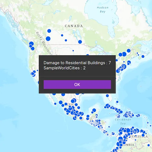
IdentifyLayers allows users to tap on a map, returning features at that location across multiple layers. Because some layer types have sublayers, the sample recursively counts results for sublayers within each layer.
How to use the sample
Tap to identify features. An alert will show all layers with features under the cursor, as well as a layer count.
How it works
- The tapped position is passed to
MapView::identifyLayers - For each
IdentifyLayerResultin the results, features are counted.- Note: there is one identify result per layer with matching features; if the feature count is 0, that means a sublayer contains the matching features.
Relevant API
- IdentifyLayerResult
- IdentifyLayerResult::layerContent::name
- IdentifyLayerResult::sublayerResults
- MapView::identifyLayers
Additional information
The GeoView supports two methods of identify: identifyLayer(), which identifies features within a specific layer and identifyLayers(), which identifies features for all layers in the current view.
Tags
identify, recursion, recursive, sublayers
Sample code
// [WriteFile Name=IdentifyLayers, Category=Maps]// [Legal]// Copyright 2017 Esri.//// Licensed under the Apache License, Version 2.0 (the "License");// you may not use this file except in compliance with the License.// You may obtain a copy of the License at// http://www.apache.org/licenses/LICENSE-2.0//// Unless required by applicable law or agreed to in writing, software// distributed under the License is distributed on an "AS IS" BASIS,// WITHOUT WARRANTIES OR CONDITIONS OF ANY KIND, either express or implied.// See the License for the specific language governing permissions and// limitations under the License.// [Legal]
#ifdef PCH_BUILD#include "pch.hpp"#endif // PCH_BUILD
// sample headers#include "IdentifyLayers.h"
// ArcGIS Maps SDK headers#include "ArcGISMapImageLayer.h"#include "ArcGISSublayer.h"#include "ArcGISSublayerListModel.h"#include "Basemap.h"#include "Error.h"#include "FeatureLayer.h"#include "IdentifyLayerResult.h"#include "LayerListModel.h"#include "Map.h"#include "MapQuickView.h"#include "MapTypes.h"#include "Point.h"#include "ServiceFeatureTable.h"#include "SpatialReference.h"#include "Viewpoint.h"
// Qt headers#include <QFuture>#include <QQueue>#include <QUuid>
using namespace Esri::ArcGISRuntime;
IdentifyLayers::IdentifyLayers(QQuickItem* parent /* = nullptr */) :  QQuickItem(parent){}
void IdentifyLayers::init(){  // Register the map view for QML  qmlRegisterType<MapQuickView>("Esri.Samples", 1, 0, "MapView");  qmlRegisterType<IdentifyLayers>("Esri.Samples", 1, 0, "IdentifyLayersSample");}
void IdentifyLayers::componentComplete(){  QQuickItem::componentComplete();
  // find QML MapView component  m_mapView = findChild<MapQuickView*>("mapView");
  // Create a map using the topographic basemap  m_map = new Map(BasemapStyle::ArcGISTopographic, this);
  // add a map image layer  QUrl mapServiceUrl("https://sampleserver6.arcgisonline.com/arcgis/rest/services/SampleWorldCities/MapServer");  ArcGISMapImageLayer* imageLayer = new ArcGISMapImageLayer(mapServiceUrl, this);  m_map->operationalLayers()->append(imageLayer);
  // hide 2 of the sublayers in the map image layer  connect(imageLayer, &ArcGISMapImageLayer::doneLoading, this, [imageLayer](const Error& e)  {    if (!e.isEmpty())    {      qDebug() << e.message() << e.additionalMessage();      return;    }
    imageLayer->mapImageSublayers()->at(1)->setVisible(false);    imageLayer->mapImageSublayers()->at(2)->setVisible(false);  });
  // add a feature layer  QUrl featureLayerUrl("https://sampleserver6.arcgisonline.com/arcgis/rest/services/DamageAssessment/FeatureServer/0");  ServiceFeatureTable* featureTable = new ServiceFeatureTable(featureLayerUrl, this);  FeatureLayer* featureLayer = new FeatureLayer(featureTable, this);  m_map->operationalLayers()->append(featureLayer);
  // set an initial viewpoint  const double mapScale = 68015210;  const double x = -10977012.785807;  const double y = 4514257.550369;  const Point pt(x, y, SpatialReference::webMercator());  Viewpoint initialViewpoint(pt, mapScale);  m_map->setInitialViewpoint(initialViewpoint);
  // Set map to map view  m_mapView->setMap(m_map);
  // connect signals  connectSignals();}
void IdentifyLayers::connectSignals(){  // identify layers on mouse click  connect(m_mapView, &MapQuickView::mouseClicked, this, [this](QMouseEvent& mouseEvent)  {    const double tolerance = 12.0;    const bool returnPopups = false;    const int maxResults = 10;
    m_mapView->identifyLayersAsync(mouseEvent.position(), tolerance, returnPopups, maxResults)      .then(this, [this](const QList<IdentifyLayerResult*>& results)    {      // reset the message text      m_message = QString();
      for (IdentifyLayerResult* result : results)      {        // lambda for calculating result count        auto geoElementsCountFromResult = [](IdentifyLayerResult* result) -> int        {          // create temp list          QList<IdentifyLayerResult*> tempResults{result};
          // use Depth First Search approach to handle recursion          int count = 0;          int index = 0;
          while (index < tempResults.length())          {            //get the result object from the array            IdentifyLayerResult* identifyResult = tempResults[index];
            // update count with geoElements from the result            count += identifyResult->geoElements().length();
            // check if the result has any sublayer results            // if yes then add those result objects in the tempResults            // array after the current result            if (identifyResult->sublayerResults().length() > 0)            {              tempResults.append(identifyResult->sublayerResults().at(index));            }
            // update the count and repeat            index += 1;          }          return count;        };
        const int count = geoElementsCountFromResult(result);        QString layerName = result->layerContent()->name();        m_message += QString("%1 : %2").arg(layerName).arg(count);        m_message += "\n";      }      //remove last newline character      if (!m_message.isEmpty())      {        m_message.chop(1);      }
      emit messageChanged();      emit showMessage();      qDeleteAll(results);    });  });}
// [WriteFile Name=IdentifyLayers, Category=Maps]// [Legal]// Copyright 2017 Esri.//// Licensed under the Apache License, Version 2.0 (the "License");// you may not use this file except in compliance with the License.// You may obtain a copy of the License at// http://www.apache.org/licenses/LICENSE-2.0//// Unless required by applicable law or agreed to in writing, software// distributed under the License is distributed on an "AS IS" BASIS,// WITHOUT WARRANTIES OR CONDITIONS OF ANY KIND, either express or implied.// See the License for the specific language governing permissions and// limitations under the License.// [Legal]
#ifndef IDENTIFYLAYERS_H#define IDENTIFYLAYERS_H
// Qt headers#include <QQuickItem>
namespace Esri::ArcGISRuntime{ class Map; class MapQuickView;} // namespace Esri::ArcGISRuntime
class IdentifyLayers : public QQuickItem{ Q_OBJECT Q_PROPERTY(QString message MEMBER m_message NOTIFY messageChanged)
public: explicit IdentifyLayers(QQuickItem* parent = nullptr); ~IdentifyLayers() override = default;
void componentComplete() override; static void init();
signals: void messageChanged(); void showMessage();
private: void connectSignals();
private: Esri::ArcGISRuntime::Map* m_map = nullptr; Esri::ArcGISRuntime::MapQuickView* m_mapView = nullptr; QString m_message;};
#endif // IDENTIFYLAYERS_H// [WriteFile Name=IdentifyLayers, Category=Maps]// [Legal]// Copyright 2017 Esri.//// Licensed under the Apache License, Version 2.0 (the "License");// you may not use this file except in compliance with the License.// You may obtain a copy of the License at// http://www.apache.org/licenses/LICENSE-2.0//// Unless required by applicable law or agreed to in writing, software// distributed under the License is distributed on an "AS IS" BASIS,// WITHOUT WARRANTIES OR CONDITIONS OF ANY KIND, either express or implied.// See the License for the specific language governing permissions and// limitations under the License.// [Legal]
import QtQuickimport QtQuick.Controlsimport Esri.Samples
IdentifyLayersSample { id: rootRectangle clip: true width: 800 height: 600
// add a mapView component MapView { anchors.fill: parent objectName: "mapView"
Component.onCompleted: { // Set the focus on MapView to initially enable keyboard navigation forceActiveFocus(); } }
Dialog { id: msgDialog modal: true x: Math.round(parent.width - width) / 2 y: Math.round(parent.height - height) / 2 standardButtons: Dialog.Ok property alias text : textLabel.text Label { id: textLabel text: message } }
onShowMessage: { if (message.length > 0) msgDialog.open(); }}