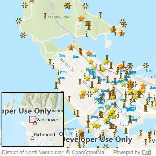
Include an overview or inset map as an additional map view to show the wider context of the primary view.
Use case
An overview map provides a useful, smaller-scale overview of the current map view’s location. For example, when you need to inspect a layer with many features while remaining aware of the wider context of the view, use an overview map to help show the extent of the main map view.
How to use the sample
Pan or zoom across the map view to browse through the tourist attractions feature layer and watch the viewpoint or scale of the linked overview map update automatically. You can also navigate by panning and zooming on the overview map directly.
How it works
- Create a
Mapwith theArcGISTopographicbasemap style and add it to theMapView. - Instantiate a
FeatureLayerfrom aServiceFeatureTableand append it to theMap’s operational layers. - In the user-interface, declare an
OverviewMapobject from the ArcGIS Maps SDK for Qt Toolkit. - Assign the
MapViewto thegeoViewproperty of theOverviewMapto connect theMapViewwith theOverviewMap.
Relevant API
- MapView
- OverviewMap
About the data
The data used in this sample is the OpenStreetMap Tourist Attractions for North America feature layer, which is scale-dependent and displays at scales larger than 1:160,000.
Additional information
This sample uses the overview map toolkit component, which requires the toolkit to be cloned and set up locally. For information about setting up the toolkit, visit the repository’s UI Tools page.
Tags
context, inset, map, minimap, overview, preview, small scale, toolkit, view
Sample code
// [WriteFile Name=DisplayOverviewMap, Category=Maps]// [Legal]// Copyright 2021 Esri.//// Licensed under the Apache License, Version 2.0 (the "License");// you may not use this file except in compliance with the License.// You may obtain a copy of the License at// http://www.apache.org/licenses/LICENSE-2.0//// Unless required by applicable law or agreed to in writing, software// distributed under the License is distributed on an "AS IS" BASIS,// WITHOUT WARRANTIES OR CONDITIONS OF ANY KIND, either express or implied.// See the License for the specific language governing permissions and// limitations under the License.// [Legal]
#ifdef PCH_BUILD#include "pch.hpp"#endif // PCH_BUILD
// sample headers#include "DisplayOverviewMap.h"
// ArcGIS Maps SDK headers#include "Basemap.h"#include "FeatureLayer.h"#include "GeodatabaseTypes.h"#include "LayerListModel.h"#include "Map.h"#include "MapQuickView.h"#include "MapTypes.h"#include "ServiceFeatureTable.h"#include "Viewpoint.h"
using namespace Esri::ArcGISRuntime;
DisplayOverviewMap::DisplayOverviewMap(QObject* parent /* = nullptr */) :  QObject(parent),  m_map(new Map(new Basemap(BasemapStyle::ArcGISTopographic, this), this)){  m_map->setInitialViewpoint(Viewpoint(49.28299, -123.12052, 66619));
  // Access the feature layer and add it to the maps operational layers.  ServiceFeatureTable* serviceFeatureTable =    new ServiceFeatureTable(QUrl("https://services6.arcgis.com/Do88DoK2xjTUCXd1/arcgis/rest/services/OSM_NA_Tourism/FeatureServer/0"), this);  serviceFeatureTable->setFeatureRequestMode(FeatureRequestMode::OnInteractionCache);  FeatureLayer* featureLayer = new FeatureLayer(serviceFeatureTable, this);  m_map->operationalLayers()->append(featureLayer);}
DisplayOverviewMap::~DisplayOverviewMap() = default;
void DisplayOverviewMap::init(){  // Register the map view for QML  qmlRegisterType<MapQuickView>("Esri.Samples", 1, 0, "MapView");  qmlRegisterType<DisplayOverviewMap>("Esri.Samples", 1, 0, "DisplayOverviewMapSample");}
MapQuickView* DisplayOverviewMap::mapView() const{  return m_mapView;}
// Set the view (created in QML)void DisplayOverviewMap::setMapView(MapQuickView* mapView){  if (!mapView || mapView == m_mapView)  {    return;  }
  m_mapView = mapView;  m_mapView->setMap(m_map);
  emit mapViewChanged();}
// [WriteFile Name=DisplayOverviewMap, Category=Maps]// [Legal]// Copyright 2021 Esri.//// Licensed under the Apache License, Version 2.0 (the "License");// you may not use this file except in compliance with the License.// You may obtain a copy of the License at// http://www.apache.org/licenses/LICENSE-2.0//// Unless required by applicable law or agreed to in writing, software// distributed under the License is distributed on an "AS IS" BASIS,// WITHOUT WARRANTIES OR CONDITIONS OF ANY KIND, either express or implied.// See the License for the specific language governing permissions and// limitations under the License.// [Legal]
#ifndef DISPLAYOVERVIEWMAP_H#define DISPLAYOVERVIEWMAP_H
// Qt headers#include <QObject>
namespace Esri::ArcGISRuntime{ class Map; class MapQuickView;} // namespace Esri::ArcGISRuntime
Q_MOC_INCLUDE("MapQuickView.h")
class DisplayOverviewMap : public QObject{ Q_OBJECT
Q_PROPERTY(Esri::ArcGISRuntime::MapQuickView* mapView READ mapView WRITE setMapView NOTIFY mapViewChanged)
public: explicit DisplayOverviewMap(QObject* parent = nullptr); ~DisplayOverviewMap();
static void init();
signals: void mapViewChanged();
private: Esri::ArcGISRuntime::MapQuickView* mapView() const; void setMapView(Esri::ArcGISRuntime::MapQuickView* mapView);
Esri::ArcGISRuntime::Map* m_map = nullptr; Esri::ArcGISRuntime::MapQuickView* m_mapView = nullptr;};
#endif // DISPLAYOVERVIEWMAP_H// [WriteFile Name=DisplayOverviewMap, Category=Maps]// [Legal]// Copyright 2021 Esri.//// Licensed under the Apache License, Version 2.0 (the "License");// you may not use this file except in compliance with the License.// You may obtain a copy of the License at// http://www.apache.org/licenses/LICENSE-2.0//// Unless required by applicable law or agreed to in writing, software// distributed under the License is distributed on an "AS IS" BASIS,// WITHOUT WARRANTIES OR CONDITIONS OF ANY KIND, either express or implied.// See the License for the specific language governing permissions and// limitations under the License.// [Legal]
import QtQuickimport QtQuick.Controlsimport Esri.Samplesimport Esri.ArcGISRuntime.Toolkit
Item {
// add a mapView component MapView { id: view anchors.fill: parent
Rectangle { id: overviewMapBorder width: view.width * 0.4 height: view.height * 0.35 anchors { left: view.left leftMargin: 5 bottom: view.attributionTop bottomMargin: 5 } color: "transparent" border.color: "black" border.width: 2
OverviewMap { id: overviewMap anchors { fill: overviewMapBorder margins: 2 } scaleFactor: 0.5 geoView: view } } }
// Declare the C++ instance which creates the map etc. and supply the view DisplayOverviewMapSample { id: model mapView: view }}