Get the draw status of your map view or scene view to know when all layers in the map or scene have finished drawing.
Use case
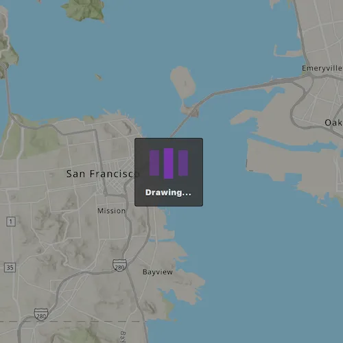
You may want to display a loading indicator while layers are loading.
How it works
- Create a
MapViewand connect to theMapQuickView::drawStatusChangedsignal. - Use
drawStatuson the to determine draw status.
Relevant API
- Map
- drawStatus
- MapQuickView::drawStatusChanged
- MapView
Tags
draw, loading, map, render
Sample code
// [WriteFile Name=DisplayDrawingStatus, Category=Maps]// [Legal]// Copyright 2016 Esri.//// Licensed under the Apache License, Version 2.0 (the "License");// you may not use this file except in compliance with the License.// You may obtain a copy of the License at// http://www.apache.org/licenses/LICENSE-2.0//// Unless required by applicable law or agreed to in writing, software// distributed under the License is distributed on an "AS IS" BASIS,// WITHOUT WARRANTIES OR CONDITIONS OF ANY KIND, either express or implied.// See the License for the specific language governing permissions and// limitations under the License.// [Legal]
#ifdef PCH_BUILD#include "pch.hpp"#endif // PCH_BUILD
// sample headers#include "DisplayDrawingStatus.h"
// ArcGIS Maps SDK headers#include "Envelope.h"#include "FeatureLayer.h"#include "LayerListModel.h"#include "Map.h"#include "MapQuickView.h"#include "MapTypes.h"#include "MapViewTypes.h"#include "ServiceFeatureTable.h"#include "SpatialReference.h"#include "Viewpoint.h"
// Qt headers#include <QUrl>
using namespace Esri::ArcGISRuntime;
DisplayDrawingStatus::DisplayDrawingStatus(QQuickItem* parent) :  QQuickItem(parent){}
DisplayDrawingStatus::~DisplayDrawingStatus() = default;
void DisplayDrawingStatus::init(){  qmlRegisterType<MapQuickView>("Esri.Samples", 1, 0, "MapView");  qmlRegisterType<DisplayDrawingStatus>("Esri.Samples", 1, 0, "DisplayDrawingStatusSample");}
void DisplayDrawingStatus::componentComplete(){  QQuickItem::componentComplete();
  // find QML MapView component  m_mapView = findChild<MapQuickView*>("mapView");  m_mapView->setWrapAroundMode(WrapAroundMode::Disabled);
  // Create a map using the topographic basemap  m_map = new Map(BasemapStyle::ArcGISTopographic, this);  m_map->setInitialViewpoint(Viewpoint(Envelope(-13639984, 4537387, -13606734, 4558866, SpatialReference::webMercator())));
  // create feature layer  ServiceFeatureTable* featureTable =    new ServiceFeatureTable(QUrl("https://sampleserver6.arcgisonline.com/arcgis/rest/services/DamageAssessment/FeatureServer/0"), this);  m_featureLayer = new FeatureLayer(featureTable, this);
  // add the layer to the map  m_map->operationalLayers()->append(m_featureLayer);
  // Set map to map view  m_mapView->setMap(m_map);
  connect(m_mapView, &MapQuickView::drawStatusChanged, this, [this](DrawStatus drawStatus)  {    m_mapDrawing = (drawStatus == DrawStatus::InProgress);    emit mapDrawStatusChanged();  });}
bool DisplayDrawingStatus::mapDrawing() const{  return m_mapDrawing;}
// [WriteFile Name=DisplayDrawingStatus, Category=Maps]// [Legal]// Copyright 2016 Esri.//// Licensed under the Apache License, Version 2.0 (the "License");// you may not use this file except in compliance with the License.// You may obtain a copy of the License at// http://www.apache.org/licenses/LICENSE-2.0//// Unless required by applicable law or agreed to in writing, software// distributed under the License is distributed on an "AS IS" BASIS,// WITHOUT WARRANTIES OR CONDITIONS OF ANY KIND, either express or implied.// See the License for the specific language governing permissions and// limitations under the License.// [Legal]
#ifndef DISPLAYDRAWINGSTATUS_H#define DISPLAYDRAWINGSTATUS_H
// Qt headers#include <QQuickItem>
namespace Esri::ArcGISRuntime{ class Map; class MapQuickView; class FeatureLayer;} // namespace Esri::ArcGISRuntime
class DisplayDrawingStatus : public QQuickItem{ Q_OBJECT
Q_PROPERTY(bool mapDrawing READ mapDrawing NOTIFY mapDrawStatusChanged)
public: explicit DisplayDrawingStatus(QQuickItem* parent = nullptr); ~DisplayDrawingStatus() override;
void componentComplete() override; static void init();
signals: void mapDrawStatusChanged();
private: bool mapDrawing() const;
private: Esri::ArcGISRuntime::Map* m_map = nullptr; Esri::ArcGISRuntime::MapQuickView* m_mapView = nullptr; Esri::ArcGISRuntime::FeatureLayer* m_featureLayer = nullptr; bool m_mapDrawing = false;};
#endif // DISPLAYDRAWINGSTATUS_H// [WriteFile Name=DisplayDrawingStatus, Category=Maps]// [Legal]// Copyright 2016 Esri.//// Licensed under the Apache License, Version 2.0 (the "License");// you may not use this file except in compliance with the License.// You may obtain a copy of the License at// http://www.apache.org/licenses/LICENSE-2.0//// Unless required by applicable law or agreed to in writing, software// distributed under the License is distributed on an "AS IS" BASIS,// WITHOUT WARRANTIES OR CONDITIONS OF ANY KIND, either express or implied.// See the License for the specific language governing permissions and// limitations under the License.// [Legal]
import QtQuickimport QtQuick.Controlsimport Esri.Samples
DisplayDrawingStatusSample { id: displayDrawingStatusSample clip: true width: 800 height: 600
// add a mapView component MapView { anchors.fill: parent objectName: "mapView"
Component.onCompleted: { // Set the focus on MapView to initially enable keyboard navigation forceActiveFocus(); } }
// dim window if map is drawing Rectangle { anchors.fill: parent color: "transparent" visible: displayDrawingStatusSample.mapDrawing
Rectangle { anchors.fill: parent color: "#60000000" }
// pop up to show if MapView is drawing Rectangle { anchors.centerIn: parent width: 100 height: 100 radius: 3 opacity: 0.85 color: palette.base border.color: "black"
Column { anchors { centerIn: parent topMargin: 5 } spacing: 5
BusyIndicator { anchors.horizontalCenter: parent.horizontalCenter height: 60 running: displayDrawingStatusSample.mapDrawing }
Label { anchors.horizontalCenter: parent.horizontalCenter font { weight: Font.Black pixelSize: 12 } height: 20 horizontalAlignment: Text.AlignHCenter text: qsTr("Drawing...") } } } }}