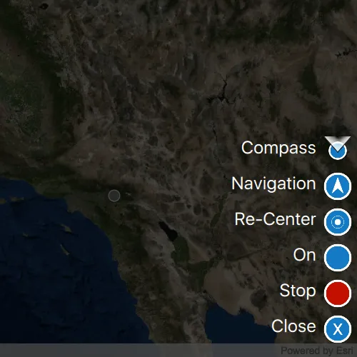
Display your current position on the map, as well as switch between different types of auto pan modes.
Use case
When using a map within a GIS, it may be helpful for a user to know their own location within a map, whether that’s to aid the user’s navigation or to provide an easy means of identifying/collecting geospatial information at their location.
How to use the sample
Tap the button in the lower right (which starts in Stop mode). A menu will appear with the following options:
- Stop - Stops the location display.
- On - Starts the location display with no
AutoPanModemode set. - Re-Center - Starts the location display with auto pan mode set to
LocationDisplayAutoPanMode::Recenter. - Navigation - Starts the location display with auto pan mode set to
LocationDisplayAutoPanMode::Navigation. - Compass - Starts the location display with auto pan mode set to
LocationDisplayAutoPanMode::CompassNavigation.
How it works
- Create a
MapView. - Get the
LocationDisplayobject by callinglocationDisplay()on the map view. - Use
start()andstop()on theLocationDisplayobject as necessary.
Relevant API
- LocationDisplay
- LocationDisplay::setAutoPanMode
- Map
- MapView
Additional information
Location permissions are required for this sample.
Tags
compass, GPS, location, map, mobile, navigation
Sample code
// [WriteFile Name=DisplayDeviceLocation, Category=Maps]// [Legal]// Copyright 2016 Esri.//// Licensed under the Apache License, Version 2.0 (the "License");// you may not use this file except in compliance with the License.// You may obtain a copy of the License at// http://www.apache.org/licenses/LICENSE-2.0//// Unless required by applicable law or agreed to in writing, software// distributed under the License is distributed on an "AS IS" BASIS,// WITHOUT WARRANTIES OR CONDITIONS OF ANY KIND, either express or implied.// See the License for the specific language governing permissions and// limitations under the License.// [Legal]
#ifdef PCH_BUILD#include "pch.hpp"#endif // PCH_BUILD
// sample headers#include "DisplayDeviceLocation.h"
// ArcGIS Maps SDK headers#include "Basemap.h"#include "LocationDisplay.h"#include "Map.h"#include "MapQuickView.h"#include "MapTypes.h"#include "MapViewTypes.h"
// Qt headers#include <QPermissions>
using namespace Esri::ArcGISRuntime;
const QString DisplayDeviceLocation::s_compassMode = QStringLiteral("Compass");const QString DisplayDeviceLocation::s_navigationMode = QStringLiteral("Navigation");const QString DisplayDeviceLocation::s_recenterMode = QStringLiteral("Re-Center");const QString DisplayDeviceLocation::s_onMode = QStringLiteral("On");const QString DisplayDeviceLocation::s_stopMode = QStringLiteral("Stop");const QString DisplayDeviceLocation::s_closeMode = QStringLiteral("Close");
DisplayDeviceLocation::DisplayDeviceLocation(QQuickItem* parent) :  QQuickItem(parent){}
DisplayDeviceLocation::~DisplayDeviceLocation(){  m_mapView->locationDisplay()->stop();}
void DisplayDeviceLocation::init(){  qmlRegisterType<MapQuickView>("Esri.Samples", 1, 0, "MapView");  qmlRegisterType<DisplayDeviceLocation>("Esri.Samples", 1, 0, "DisplayDeviceLocationSample");}
void DisplayDeviceLocation::componentComplete(){  QQuickItem::componentComplete();
  // find QML MapView component  m_mapView = findChild<MapQuickView*>("mapView");
  // create a new basemap instance  Basemap* basemap = new Basemap(BasemapStyle::ArcGISImageryStandard, this);
  // create a new map instance  m_map = new Map(basemap, this);
  // set map on the map view  m_mapView->setMap(m_map);}
void DisplayDeviceLocation::startLocationDisplay(){  QLocationPermission locationPermission{};  locationPermission.setAccuracy(QLocationPermission::Accuracy::Precise);  locationPermission.setAvailability(QLocationPermission::Availability::WhenInUse);  switch (qApp->checkPermission(locationPermission))  {    case Qt::PermissionStatus::Undetermined:      qApp->requestPermission(locationPermission, this, &DisplayDeviceLocation::startLocationDisplay);      return;    case Qt::PermissionStatus::Granted:      //! [start location display api snippet]      // turn on the location display      m_mapView->locationDisplay()->start();      //! [start location display api snippet]      return;    case Qt::PermissionStatus::Denied:      emit locationPermissionDenied();      return;  }}
void DisplayDeviceLocation::stopLocationDisplay(){  // stop location display  m_mapView->locationDisplay()->stop();}
void DisplayDeviceLocation::setAutoPanMode(QString autoPanMode){  // set the correct auto pan mode on the location display  if (autoPanMode == compassMode())  {    m_mapView->locationDisplay()->setAutoPanMode(LocationDisplayAutoPanMode::CompassNavigation);  }  else if (autoPanMode == navigationMode())  {    m_mapView->locationDisplay()->setAutoPanMode(LocationDisplayAutoPanMode::Navigation);  }  else if (autoPanMode == recenterMode())  {    m_mapView->locationDisplay()->setAutoPanMode(LocationDisplayAutoPanMode::Recenter);  }  else if (autoPanMode == stopMode())  {    m_mapView->locationDisplay()->setAutoPanMode(LocationDisplayAutoPanMode::Off);  }  else if (autoPanMode == onMode())  {    m_mapView->locationDisplay()->setAutoPanMode(LocationDisplayAutoPanMode::Off);  }}
const QString DisplayDeviceLocation::compassMode(){  return s_compassMode;}
const QString DisplayDeviceLocation::navigationMode(){  return s_navigationMode;}
const QString DisplayDeviceLocation::recenterMode(){  return s_recenterMode;}
const QString DisplayDeviceLocation::onMode(){  return s_onMode;}
const QString DisplayDeviceLocation::stopMode(){  return s_stopMode;}
const QString DisplayDeviceLocation::closeMode(){  return s_closeMode;}
// [WriteFile Name=DisplayDeviceLocation, Category=Maps]// [Legal]// Copyright 2016 Esri.//// Licensed under the Apache License, Version 2.0 (the "License");// you may not use this file except in compliance with the License.// You may obtain a copy of the License at// http://www.apache.org/licenses/LICENSE-2.0//// Unless required by applicable law or agreed to in writing, software// distributed under the License is distributed on an "AS IS" BASIS,// WITHOUT WARRANTIES OR CONDITIONS OF ANY KIND, either express or implied.// See the License for the specific language governing permissions and// limitations under the License.// [Legal]
#ifndef DISPLAY_DEVICE_LOCATION_H#define DISPLAY_DEVICE_LOCATION_H
// Qt headers#include <QQuickItem>
namespace Esri::ArcGISRuntime{ class Map; class MapQuickView;} // namespace Esri::ArcGISRuntime
class DisplayDeviceLocation : public QQuickItem{ Q_OBJECT
Q_PROPERTY(QString compassMode READ compassMode NOTIFY compassModeChanged) Q_PROPERTY(QString navigationMode READ navigationMode NOTIFY navigationModeChanged) Q_PROPERTY(QString recenterMode READ recenterMode NOTIFY recenterModeChanged) Q_PROPERTY(QString onMode READ onMode NOTIFY onModeChanged) Q_PROPERTY(QString stopMode READ stopMode NOTIFY stopModeChanged) Q_PROPERTY(QString closeMode READ closeMode NOTIFY closeModeChanged)
public: explicit DisplayDeviceLocation(QQuickItem* parent = nullptr); ~DisplayDeviceLocation() override;
void componentComplete() override; static void init(); Q_INVOKABLE void startLocationDisplay(); Q_INVOKABLE void stopLocationDisplay(); Q_INVOKABLE void setAutoPanMode(QString autoPanMode);
signals: void compassModeChanged(); void navigationModeChanged(); void recenterModeChanged(); void onModeChanged(); void stopModeChanged(); void closeModeChanged();
void locationPermissionDenied();
private: static const QString compassMode(); static const QString navigationMode(); static const QString recenterMode(); static const QString onMode(); static const QString stopMode(); static const QString closeMode();
private: Esri::ArcGISRuntime::Map* m_map = nullptr; Esri::ArcGISRuntime::MapQuickView* m_mapView = nullptr; static const QString s_compassMode; static const QString s_navigationMode; static const QString s_recenterMode; static const QString s_onMode; static const QString s_stopMode; static const QString s_closeMode;};
#endif // DISPLAY_DEVICE_LOCATION_H// [WriteFile Name=DisplayDeviceLocation, Category=Maps]// [Legal]// Copyright 2016 Esri.//// Licensed under the Apache License, Version 2.0 (the "License");// you may not use this file except in compliance with the License.// You may obtain a copy of the License at// http://www.apache.org/licenses/LICENSE-2.0//// Unless required by applicable law or agreed to in writing, software// distributed under the License is distributed on an "AS IS" BASIS,// WITHOUT WARRANTIES OR CONDITIONS OF ANY KIND, either express or implied.// See the License for the specific language governing permissions and// limitations under the License.// [Legal]
import QtQuickimport QtQuick.Controlsimport QtQuick.Dialogsimport Esri.Samples
DisplayDeviceLocationSample { id: deviceLocationSample width: 800 height: 600
property string currentModeText: deviceLocationSample.stopMode property string currentModeImage: "qrc:/Samples/Maps/DisplayDeviceLocation/Stop.png"
// add a mapView component MapView { anchors.fill: parent objectName: "mapView"
Component.onCompleted: { // Set the focus on MapView to initially enable keyboard navigation forceActiveFocus();
// populate list model with modes autoPanListModel.append({name: deviceLocationSample.compassMode, image: "qrc:/Samples/Maps/DisplayDeviceLocation/Compass.png"}); autoPanListModel.append({name: deviceLocationSample.navigationMode, image: "qrc:/Samples/Maps/DisplayDeviceLocation/Navigation.png"}); autoPanListModel.append({name: deviceLocationSample.recenterMode, image: "qrc:/Samples/Maps/DisplayDeviceLocation/Re-Center.png"}); autoPanListModel.append({name: deviceLocationSample.onMode, image: "qrc:/Samples/Maps/DisplayDeviceLocation/On.png"}); autoPanListModel.append({name: deviceLocationSample.stopMode, image: "qrc:/Samples/Maps/DisplayDeviceLocation/Stop.png"}); autoPanListModel.append({name: deviceLocationSample.closeMode, image: "qrc:/Samples/Maps/DisplayDeviceLocation/Close.png"}); } }
Rectangle { id: rect anchors.fill: parent visible: autoPanListView.visible color: "black" opacity: 0.7 }
ListView { id: autoPanListView anchors { right: parent.right bottom: parent.bottom margins: 10 } visible: false width: parent.width height: 300 spacing: 10 model: ListModel { id: autoPanListModel }
delegate: Row { id: autopanRow anchors.right: parent.right spacing: 10
Text { text: name font.pixelSize: 25 color: "white" MouseArea { anchors.fill: parent // When an item in the list view is clicked onClicked: { autopanRow.updateAutoPanMode(); } } }
Image { source: image width: 40 height: width MouseArea { anchors.fill: parent // When an item in the list view is clicked onClicked: { autopanRow.updateAutoPanMode(); } } }
// set the appropriate auto pan mode function updateAutoPanMode() { switch (name) { case deviceLocationSample.compassMode: deviceLocationSample.setAutoPanMode(deviceLocationSample.compassMode); deviceLocationSample.startLocationDisplay(); break; case deviceLocationSample.navigationMode: deviceLocationSample.setAutoPanMode(deviceLocationSample.navigationMode); deviceLocationSample.startLocationDisplay(); break; case deviceLocationSample.recenterMode: deviceLocationSample.setAutoPanMode(deviceLocationSample.recenterMode); deviceLocationSample.startLocationDisplay(); break; case deviceLocationSample.onMode: deviceLocationSample.setAutoPanMode(deviceLocationSample.onMode); deviceLocationSample.startLocationDisplay(); break; case deviceLocationSample.stopMode: deviceLocationSample.stopLocationDisplay(); break; }
if (name !== deviceLocationSample.closeMode) { currentModeText = name; currentModeImage = image; }
// hide the list view currentAction.visible = true; autoPanListView.visible = false; } } }
Row { id: currentAction anchors { right: parent.right bottom: parent.bottom margins: 10 bottomMargin: 25 } spacing: 10
Text { text: currentModeText font.pixelSize: 25 color: "white" MouseArea { anchors.fill: parent onClicked: { currentAction.visible = false; autoPanListView.visible = true; } } }
Image { source: currentModeImage width: 40 height: width MouseArea { anchors.fill: parent onClicked: { currentAction.visible = false; autoPanListView.visible = true; } } } }
Connections { target: deviceLocationSample function onLocationPermissionDenied() { permissionDeniedDialog.open() } }
Dialog { id: permissionDeniedDialog title: qsTr("Location Permission Denied") modal: true standardButtons: Dialog.Ok x: (parent.width - width) / 2 y: (parent.height - height) / 2
Label { text: qsTr("This application requires location permissions.") } }}