Cut a geometry along a polyline.
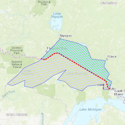
Use case
You might cut a polygon representing a large parcel to subdivide it into smaller parcels.
How to use the sample
Click “Cut” to cut the polygon with the polyline and see the resulting parts (shaded in different colors).
How it works
- Pass the geometry and polyline to
GeometryEngine::cutto cut the geometry along the polyline. - Create a new
Graphicfor each in the list of cut geometries and add them to theGraphicsOverlayon theMapView.
Relevant API
- GeometryEngine::cut
- Polygon
- Polyline
Tags
cut, geometry, split
Sample code
// [WriteFile Name=CutGeometry, Category=Geometry]// [Legal]// Copyright 2018 Esri.//// Licensed under the Apache License, Version 2.0 (the "License");// you may not use this file except in compliance with the License.// You may obtain a copy of the License at// http://www.apache.org/licenses/LICENSE-2.0//// Unless required by applicable law or agreed to in writing, software// distributed under the License is distributed on an "AS IS" BASIS,// WITHOUT WARRANTIES OR CONDITIONS OF ANY KIND, either express or implied.// See the License for the specific language governing permissions and// limitations under the License.// [Legal]
#ifdef PCH_BUILD#include "pch.hpp"#endif // PCH_BUILD
// sample headers#include "CutGeometry.h"
// ArcGIS Maps SDK headers#include "GeometryEngine.h"#include "Graphic.h"#include "GraphicListModel.h"#include "GraphicsOverlay.h"#include "GraphicsOverlayListModel.h"#include "Map.h"#include "MapQuickView.h"#include "MapTypes.h"#include "PolygonBuilder.h"#include "PolylineBuilder.h"#include "SimpleFillSymbol.h"#include "SimpleLineSymbol.h"#include "SpatialReference.h"#include "SymbolTypes.h"
// Qt headers#include <QFuture>
using namespace Esri::ArcGISRuntime;
CutGeometry::CutGeometry(QQuickItem* parent /* = nullptr */) :  QQuickItem(parent){}
void CutGeometry::init(){  // Register the map view for QML  qmlRegisterType<MapQuickView>("Esri.Samples", 1, 0, "MapView");  qmlRegisterType<CutGeometry>("Esri.Samples", 1, 0, "CutGeometrySample");}
void CutGeometry::componentComplete(){  QQuickItem::componentComplete();
  // find QML MapView component  m_mapView = findChild<MapQuickView*>("mapView");
  // Create a map using the topographic basemap  m_map = new Map(BasemapStyle::ArcGISTopographic, this);
  // Set map to map view  m_mapView->setMap(m_map);
  // Add a GraphicsOverlay  m_overlay = new GraphicsOverlay(this);  m_mapView->graphicsOverlays()->append(m_overlay);
  // Create initial graphics  createGraphics();
  // Set Viewpoint  m_mapView->setViewpointGeometryAsync(m_lakeSuperiorGraphic->geometry());}
// Cuts the Lake Superior polygon into two and symbolizes each output graphicvoid CutGeometry::cutPolygon(){  // perform the cut  QList<Geometry> geoms = GeometryEngine::cut(m_lakeSuperiorGraphic->geometry(), geometry_cast<Polyline>(m_borderGraphic->geometry()));
  // create graphics for the U.S. side  SimpleLineSymbol* outline = new SimpleLineSymbol(SimpleLineSymbolStyle::Solid, QColor("blue"), 1.0f, this);  SimpleFillSymbol* usSymbol = new SimpleFillSymbol(SimpleFillSymbolStyle::ForwardDiagonal, QColor("#40ff00"), outline, this);  Graphic* usSide = new Graphic(geoms.at(0), usSymbol, this);
  // create graphics for the Canada side  SimpleFillSymbol* canadaSymbol = new SimpleFillSymbol(SimpleFillSymbolStyle::ForwardDiagonal, QColor("#ffff00"), outline, this);  Graphic* canadaSide = new Graphic(geoms.at(1), canadaSymbol, this);
  // add graphics  m_overlay->graphics()->append(canadaSide);  m_overlay->graphics()->append(usSide);}
void CutGeometry::resetPolygon(){  m_overlay->graphics()->clear();
  m_overlay->graphics()->append(m_lakeSuperiorGraphic);  m_overlay->graphics()->append(m_borderGraphic);}
// Create the two baseline graphicsvoid CutGeometry::createGraphics(){  // Lake Superior Graphic  SimpleLineSymbol* outline = new SimpleLineSymbol(SimpleLineSymbolStyle::Solid, QColor("blue"), 1.0f, this);  SimpleFillSymbol* usSymbol = new SimpleFillSymbol(SimpleFillSymbolStyle::Solid, QColor(198, 204, 255, 178), outline, this);  m_lakeSuperiorGraphic = new Graphic(createLakeSuperiorPolygon(), usSymbol, this);  m_overlay->graphics()->append(m_lakeSuperiorGraphic);
  // Border Graphic  SimpleLineSymbol* borderSymbol = new SimpleLineSymbol(SimpleLineSymbolStyle::Dot, QColor("red"), 5.0f, this);  m_borderGraphic = new Graphic(createBorderPolyline(), borderSymbol, this);  m_borderGraphic->setZIndex(10);  m_overlay->graphics()->append(m_borderGraphic);}
// Create the Lake Superior PolygonPolygon CutGeometry::createLakeSuperiorPolygon(){  PolygonBuilder* polygonBuilder = new PolygonBuilder(SpatialReference::webMercator(), this);  polygonBuilder->addPoint(-10254374.668616, 5908345.076380);  polygonBuilder->addPoint(-10178382.525314, 5971402.386779);  polygonBuilder->addPoint(-10118558.923141, 6034459.697178);  polygonBuilder->addPoint(-9993252.729399, 6093474.872295);  polygonBuilder->addPoint(-9882498.222673, 6209888.368416);  polygonBuilder->addPoint(-9821057.766387, 6274562.532928);  polygonBuilder->addPoint(-9690092.583250, 6241417.023616);  polygonBuilder->addPoint(-9605207.742329, 6206654.660191);  polygonBuilder->addPoint(-9564786.389509, 6108834.986367);  polygonBuilder->addPoint(-9449989.747500, 6095091.726408);  polygonBuilder->addPoint(-9462116.153346, 6044160.821855);  polygonBuilder->addPoint(-9417652.665244, 5985145.646738);  polygonBuilder->addPoint(-9438671.768711, 5946341.148031);  polygonBuilder->addPoint(-9398250.415891, 5922088.336339);  polygonBuilder->addPoint(-9419269.519357, 5855797.317714);  polygonBuilder->addPoint(-9467775.142741, 5858222.598884);  polygonBuilder->addPoint(-9462924.580403, 5902686.086985);  polygonBuilder->addPoint(-9598740.325877, 5884092.264688);  polygonBuilder->addPoint(-9643203.813979, 5845287.765981);  polygonBuilder->addPoint(-9739406.633691, 5879241.702350);  polygonBuilder->addPoint(-9783061.694736, 5922896.763395);  polygonBuilder->addPoint(-9844502.151022, 5936640.023354);  polygonBuilder->addPoint(-9773360.570059, 6019099.583107);  polygonBuilder->addPoint(-9883306.649729, 5968977.105610);  polygonBuilder->addPoint(-9957681.938918, 5912387.211662);  polygonBuilder->addPoint(-10055501.612742, 5871965.858842);  polygonBuilder->addPoint(-10116942.069028, 5884092.264688);  polygonBuilder->addPoint(-10111283.079633, 5933406.315128);  polygonBuilder->addPoint(-10214761.742852, 5888134.399970);  polygonBuilder->addPoint(-10254374.668616, 5901877.659929);  return polygonBuilder->toPolygon();}
// Create the U.S./Canada Border PolylinePolyline CutGeometry::createBorderPolyline(){  PolylineBuilder* polylineBuilder = new PolylineBuilder(SpatialReference::webMercator(), this);  polylineBuilder->addPoint(-9981328.687124, 6111053.281447);  polylineBuilder->addPoint(-9946518.044066, 6102350.620682);  polylineBuilder->addPoint(-9872545.427566, 6152390.920079);  polylineBuilder->addPoint(-9838822.617103, 6157830.083057);  polylineBuilder->addPoint(-9446115.050097, 5927209.572793);  polylineBuilder->addPoint(-9430885.393759, 5876081.440801);  polylineBuilder->addPoint(-9415655.737420, 5860851.784463);  return polylineBuilder->toPolyline();}
// [WriteFile Name=CutGeometry, Category=Geometry]// [Legal]// Copyright 2018 Esri.//// Licensed under the Apache License, Version 2.0 (the "License");// you may not use this file except in compliance with the License.// You may obtain a copy of the License at// http://www.apache.org/licenses/LICENSE-2.0//// Unless required by applicable law or agreed to in writing, software// distributed under the License is distributed on an "AS IS" BASIS,// WITHOUT WARRANTIES OR CONDITIONS OF ANY KIND, either express or implied.// See the License for the specific language governing permissions and// limitations under the License.// [Legal]
#ifndef CUTGEOMETRY_H#define CUTGEOMETRY_H
// ArcGIS Maps SDK headers#include "Polygon.h"#include "Polyline.h"
// Qt headers#include <QQuickItem>
namespace Esri::ArcGISRuntime{ class Map; class MapQuickView; class Graphic; class GraphicsOverlay;} // namespace Esri::ArcGISRuntime
class CutGeometry : public QQuickItem{ Q_OBJECT
public: explicit CutGeometry(QQuickItem* parent = nullptr); ~CutGeometry() override = default;
void componentComplete() override; static void init(); Q_INVOKABLE void cutPolygon(); Q_INVOKABLE void resetPolygon();
private: Esri::ArcGISRuntime::Map* m_map = nullptr; Esri::ArcGISRuntime::MapQuickView* m_mapView = nullptr; Esri::ArcGISRuntime::Graphic* m_lakeSuperiorGraphic = nullptr; Esri::ArcGISRuntime::Graphic* m_borderGraphic = nullptr; Esri::ArcGISRuntime::GraphicsOverlay* m_overlay = nullptr;
private: void createGraphics(); Esri::ArcGISRuntime::Polygon createLakeSuperiorPolygon(); Esri::ArcGISRuntime::Polyline createBorderPolyline();};
#endif // CUTGEOMETRY_H// [WriteFile Name=CutGeometry, Category=Geometry]// [Legal]// Copyright 2018 Esri.//// Licensed under the Apache License, Version 2.0 (the "License");// you may not use this file except in compliance with the License.// You may obtain a copy of the License at// http://www.apache.org/licenses/LICENSE-2.0//// Unless required by applicable law or agreed to in writing, software// distributed under the License is distributed on an "AS IS" BASIS,// WITHOUT WARRANTIES OR CONDITIONS OF ANY KIND, either express or implied.// See the License for the specific language governing permissions and// limitations under the License.// [Legal]
import QtQuickimport QtQuick.Controlsimport Esri.Samples
CutGeometrySample { id: rootRectangle clip: true width: 800 height: 600
// add a mapView component MapView { anchors.fill: parent objectName: "mapView"
Component.onCompleted: { // Set the focus on MapView to initially enable keyboard navigation forceActiveFocus(); } }
Button { id: cutOrResetButton anchors { left: parent.left top: parent.top margins: 10 }
text: qsTr("Cut") onClicked: { if (cutOrResetButton.text === "Cut") { cutPolygon(); cutOrResetButton.text = "Reset"; } else { cutOrResetButton.text = "Cut"; resetPolygon(); } } }}