Group a collection of layers together and toggle their visibility as a group.
Use case
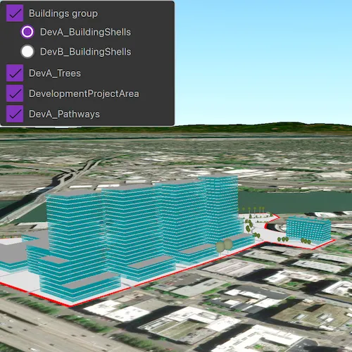
Group layers communicate to the user that layers are related and can be managed together.
In a land development project, you might group layers according to the phase of development.
How to use the sample
The layers in the map will be displayed in a table of contents. Toggle the checkbox next to a layer’s name to change its visibility. Turning a group layer’s visibility off will override the visibility of its child layers.
How it works
- Create an empty
GroupLayer. - Create a new layer and add it to the group layer’s layers collection.
- Set the group layer’s
GroupVisibilityModeto change its behavior:
GroupVisibilityMode::Independentallows each sublayer to change its visibility independently.GroupVisibilityMode::Exclusiveallows only one sublayer to be visible at a time.GroupVisibilityMode::Inheritedtreats the group layer as if it is one merged layer.
- Create a ListView and bind the model the the scene’s operational layer list model.
- Create a delegate for the group layer and and another delegate for all other layers. The group layer delegate will have nested checkboxes.
- Check that the layer is a group layer. If true, load the group layer delegate. If false, load the other delegate.
- Each delegate will use the
nameandlayerVisibleroles exposed on theLayerListModel. - To toggle the visibility of the group, simply change the group layer’s visibility property.
Relevant API
- GroupLayer
- GroupLayer::visibilityMode
- LayerContent
Additional information
The full extent of a group layer may change when child layers are added/removed. Group layers do not have a spatial reference, but the full extent will have the spatial reference of the first child layer.
Tags
3D, group layer, layers
Sample code
// [WriteFile Name=GroupLayers, Category=Layers]// [Legal]// Copyright 2019 Esri.//// Licensed under the Apache License, Version 2.0 (the "License");// you may not use this file except in compliance with the License.// You may obtain a copy of the License at// http://www.apache.org/licenses/LICENSE-2.0//// Unless required by applicable law or agreed to in writing, software// distributed under the License is distributed on an "AS IS" BASIS,// WITHOUT WARRANTIES OR CONDITIONS OF ANY KIND, either express or implied.// See the License for the specific language governing permissions and// limitations under the License.// [Legal]
#ifdef PCH_BUILD#include "pch.hpp"#endif // PCH_BUILD
// sample headers#include "GroupLayers.h"
// ArcGIS Maps SDK headers#include "ArcGISSceneLayer.h"#include "ArcGISTiledElevationSource.h"#include "ElevationSourceListModel.h"#include "Envelope.h"#include "Error.h"#include "FeatureLayer.h"#include "GroupLayer.h"#include "LayerListModel.h"#include "MapTypes.h"#include "Scene.h"#include "SceneQuickView.h"#include "ServiceFeatureTable.h"#include "Surface.h"#include "Viewpoint.h"
// Qt headers#include <QFuture>
using namespace Esri::ArcGISRuntime;
GroupLayers::GroupLayers(QObject* parent /* = nullptr */) :  QObject(parent),  m_scene(new Scene(BasemapStyle::ArcGISImageryStandard, this)){  // create a new elevation source from Terrain3D REST service  ArcGISTiledElevationSource* elevationSource =    new ArcGISTiledElevationSource(QUrl("https://elevation3d.arcgis.com/arcgis/rest/services/WorldElevation3D/Terrain3D/ImageServer"), this);
  // add the elevation source to the scene to display elevation  m_scene->baseSurface()->elevationSources()->append(elevationSource);
  // Create layers and append to a group layer  ArcGISSceneLayer* layer1 =    new ArcGISSceneLayer(QUrl("https://tiles.arcgis.com/tiles/P3ePLMYs2RVChkJx/arcgis/rest/services/DevA_BuildingShells/SceneServer"), this);  ArcGISSceneLayer* layer2 =    new ArcGISSceneLayer(QUrl("https://tiles.arcgis.com/tiles/P3ePLMYs2RVChkJx/arcgis/rest/services/DevB_BuildingShells/SceneServer"), this);  GroupLayer* groupLayer = new GroupLayer(QList<Layer*>{layer1, layer2}, this);  groupLayer->setName("Buildings group");  groupLayer->setVisibilityMode(GroupVisibilityMode::Exclusive);
  // Create additional layers  ArcGISSceneLayer* layer3 =    new ArcGISSceneLayer(QUrl("https://tiles.arcgis.com/tiles/P3ePLMYs2RVChkJx/arcgis/rest/services/DevA_Trees/SceneServer"), this);  ServiceFeatureTable* ft1 =    new ServiceFeatureTable(QUrl("https://services.arcgis.com/P3ePLMYs2RVChkJx/arcgis/rest/services/DevelopmentProjectArea/FeatureServer/0"), this);  FeatureLayer* layer4 = new FeatureLayer(ft1, this);  ServiceFeatureTable* ft2 =    new ServiceFeatureTable(QUrl("https://services.arcgis.com/P3ePLMYs2RVChkJx/arcgis/rest/services/DevA_Pathways/FeatureServer/1"), this);  FeatureLayer* layer5 = new FeatureLayer(ft2, this);
  // Add layers to the scene  m_scene->operationalLayers()->append(groupLayer);  m_scene->operationalLayers()->append(layer3);  m_scene->operationalLayers()->append(layer4);  m_scene->operationalLayers()->append(layer5);
  connect(m_scene, &Scene::doneLoading, this, [this](const Error& e)  {    m_busy = false;    emit busyChanged();
    if (!e.isEmpty())    {      return;    }
    m_layerListModel = m_scene->operationalLayers();    emit layerListModelChanged();  });}
GroupLayers::~GroupLayers() = default;
void GroupLayers::init(){  // Register classes for QML  qmlRegisterType<SceneQuickView>("Esri.Samples", 1, 0, "SceneView");  qmlRegisterType<GroupLayers>("Esri.Samples", 1, 0, "GroupLayersSample");  qmlRegisterUncreatableType<LayerListModel>("Esri.Samples", 1, 0, "AbstractListModel", "AbstractListModel is uncreateable");}
SceneQuickView* GroupLayers::sceneView() const{  return m_sceneView;}
// Set the view (created in QML)void GroupLayers::setSceneView(SceneQuickView* sceneView){  if (!sceneView || sceneView == m_sceneView)  {    return;  }
  m_sceneView = sceneView;  m_sceneView->setArcGISScene(m_scene);
  // create initial viewpoint  Geometry env = Geometry::fromJson(R"({"spatialReference":{                                    "wkid":4326                                    },                                    "xmax":-122.67960721754773,                                    "xmin":-122.68647066116789,                                    "ymax":45.53584958588318,                                    "ymin":45.531539857343745                                    })");  // zoom to viewpoint  m_sceneView->setViewpointAsync(Viewpoint(env.extent()));
  emit sceneViewChanged();}
LayerListModel* GroupLayers::getGroupLayerListModel(int layerId){  if (!m_scene)  {    return nullptr;  }
  GroupLayer* groupLayer = static_cast<GroupLayer*>(m_scene->operationalLayers()->at(layerId));
  if (groupLayer)  {    return groupLayer->layers();  }
  return nullptr;}
// [WriteFile Name=GroupLayers, Category=Layers]// [Legal]// Copyright 2019 Esri.//// Licensed under the Apache License, Version 2.0 (the "License");// you may not use this file except in compliance with the License.// You may obtain a copy of the License at// http://www.apache.org/licenses/LICENSE-2.0//// Unless required by applicable law or agreed to in writing, software// distributed under the License is distributed on an "AS IS" BASIS,// WITHOUT WARRANTIES OR CONDITIONS OF ANY KIND, either express or implied.// See the License for the specific language governing permissions and// limitations under the License.// [Legal]
#ifndef GROUPLAYERS_H#define GROUPLAYERS_H
// Qt headers#include <QObject>
namespace Esri::ArcGISRuntime{ class Scene; class SceneQuickView; class LayerListModel;} // namespace Esri::ArcGISRuntime
class QAbstractListModel;
Q_MOC_INCLUDE("SceneQuickView.h")Q_MOC_INCLUDE("LayerListModel.h")
class GroupLayers : public QObject{ Q_OBJECT
Q_PROPERTY(Esri::ArcGISRuntime::SceneQuickView* sceneView READ sceneView WRITE setSceneView NOTIFY sceneViewChanged) Q_PROPERTY(Esri::ArcGISRuntime::LayerListModel* layerListModel MEMBER m_layerListModel NOTIFY layerListModelChanged) Q_PROPERTY(bool busy MEMBER m_busy NOTIFY busyChanged)
public: explicit GroupLayers(QObject* parent = nullptr); ~GroupLayers();
static void init();
signals: void sceneViewChanged(); void layerListModelChanged(); void busyChanged();
public: Q_INVOKABLE Esri::ArcGISRuntime::LayerListModel* getGroupLayerListModel(int layerId);
private: Esri::ArcGISRuntime::SceneQuickView* sceneView() const; void setSceneView(Esri::ArcGISRuntime::SceneQuickView* sceneView);
Esri::ArcGISRuntime::Scene* m_scene = nullptr; Esri::ArcGISRuntime::SceneQuickView* m_sceneView = nullptr; Esri::ArcGISRuntime::LayerListModel* m_layerListModel = nullptr;
bool m_busy = true;};
#endif // GROUPLAYERS_H// [WriteFile Name=GroupLayers, Category=Layers]// [Legal]// Copyright 2019 Esri.//// Licensed under the Apache License, Version 2.0 (the "License");// you may not use this file except in compliance with the License.// You may obtain a copy of the License at// http://www.apache.org/licenses/LICENSE-2.0//// Unless required by applicable law or agreed to in writing, software// distributed under the License is distributed on an "AS IS" BASIS,// WITHOUT WARRANTIES OR CONDITIONS OF ANY KIND, either express or implied.// See the License for the specific language governing permissions and// limitations under the License.// [Legal]
import QtQuickimport QtQuick.Controlsimport Esri.Samples
Item {
SceneView { id: view anchors.fill: parent
Component.onCompleted: { // Set the focus on SceneView to initially enable keyboard navigation forceActiveFocus(); } }
// Declare the C++ instance which creates the scene etc. and supply the view GroupLayersSample { id: sampleModel sceneView: view }
// Create a window to display the layers Rectangle { id: layerVisibilityRect color: palette.base border.color: "darkgray" radius: 5 width: 250 height: layerVisibilityListView.contentHeight + 20 visible: !sampleModel.busy
// Create a list view to display the items ListView { id: layerVisibilityListView anchors { fill: parent margins: 10 } //clip: true spacing: 12
// Assign the model to the list model of layers model: sampleModel.layerListModel
// Assign the delegate to the delegate created above delegate: Item { height: childrenRect.height
// select the component based on the layer type // GroupLayer is LayerType int value of 22. See API doc for more details: // https://developers.arcgis.com/qt/layers/ Loader { sourceComponent: layerType === 22 ? groupLayerDelegate : layerDelegate }
// Delegate for GroupLayers - Contains secondary repeater for sublayers Component { id: groupLayerDelegate Column { spacing: 8 CheckBox { id: parentBox text: name checked: layerVisible onToggled: layerVisible = checked }
Repeater { model: sampleModel.getGroupLayerListModel(layerVisibilityListView.currentIndex) delegate: RadioButton { checked: index === 0 text: name leftPadding: indicator.width width: layerVisibilityRect.width - leftPadding onCheckedChanged: layerVisible = checked enabled: parentBox.checked } } } }
// Delegate for all other layers - standard Checkbox Component { id: layerDelegate CheckBox { text: name checked: layerVisible onToggled: layerVisible = checked; visible: name !== "" } } } } }
Rectangle { anchors.fill: parent color: "black" opacity: 0.7 visible: sampleModel.busy
BusyIndicator { anchors.centerIn: parent running: sampleModel.busy visible: running } }}