This sample demonstrates applying a dictionary renderer to a graphics overlay in a 3D scene to display military symbology.
Use case
Use a dictionary renderer on a graphics overlay to display more transient data, such as military messages coming through a local tactical network.
How to use the sample
Pan and zoom to explore military symbols on the map.
How it works
- Create a new
DictionarySymbolStyle(dictionaryPath). - Create a new
DictionaryRenderer(symbolDictionary). - Create a new
GraphicsOverlay - Set the dictionary renderer to the graphics overlay.
- Parse through the XML and create a graphic for each element.
- Use the
_wkidkey to get the geometry’s spatial reference. - Use the
_control_pointskey to get the geometry’s shape. - Create a geometry using the shape and spatial reference from above.
- Create a
Graphicfor each attribute, utilizing it’s defined geometry. - Add the graphic to the graphics overlay.
Relevant API
- DictionaryRenderer
- DictionarySymbolStyle
- GraphicsOverlay
Offline Data
To set up the sample’s offline data, see the Use offline data in the samples section of the Qt Samples repository overview.
| Link | Local Location |
|---|---|
| Mil2525d Stylx File | <userhome>/ArcGIS/Runtime/Data/styles/arcade_style/mil2525d.stylx |
| MIL-STD-2525D XML Message File | <userhome>/ArcGIS/Runtime/Data/xml/arcade_style/Mil2525DMessages.xml |
About the data
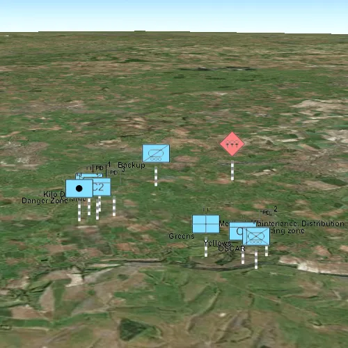
The sample opens to a view of the county Wiltshire, United Kingdom. It displays military symbols illustrating a simulated combat situation in the area.
Tags
defense, military, situational awareness, tactical, visualization
Sample code
// [WriteFile Name=GODictionaryRenderer_3D, Category=DisplayInformation]// [Legal]// Copyright 2016 Esri.//// Licensed under the Apache License, Version 2.0 (the "License");// you may not use this file except in compliance with the License.// You may obtain a copy of the License at// http://www.apache.org/licenses/LICENSE-2.0//// Unless required by applicable law or agreed to in writing, software// distributed under the License is distributed on an "AS IS" BASIS,// WITHOUT WARRANTIES OR CONDITIONS OF ANY KIND, either express or implied.// See the License for the specific language governing permissions and// limitations under the License.// [Legal]
#ifdef PCH_BUILD#include "pch.hpp"#endif // PCH_BUILD
// sample headers#include "GODictionaryRenderer_3D.h"
// ArcGIS Maps SDK headers#include "ArcGISTiledElevationSource.h"#include "Camera.h"#include "DictionaryRenderer.h"#include "DictionarySymbolStyle.h"#include "ElevationSourceListModel.h"#include "GeometryEngine.h"#include "Graphic.h"#include "GraphicListModel.h"#include "GraphicsOverlay.h"#include "GraphicsOverlayListModel.h"#include "MapTypes.h"#include "Point.h"#include "Scene.h"#include "SceneQuickView.h"#include "Surface.h"
// Qt headers#include <QFileInfo>#include <QStandardPaths>#include <QtCore/qglobal.h>
using namespace Esri::ArcGISRuntime;
// helper method to get cross platform data pathnamespace{  QString defaultDataPath()  {    QString dataPath;
#ifdef Q_OS_IOS    dataPath = QStandardPaths::writableLocation(QStandardPaths::DocumentsLocation);#else    dataPath = QStandardPaths::writableLocation(QStandardPaths::HomeLocation);#endif
    return dataPath;  }} // namespace
const QString GODictionaryRenderer_3D::FIELD_CONTROL_POINTS = "_control_points";const QString GODictionaryRenderer_3D::FIELD_WKID = "_wkid";
GODictionaryRenderer_3D::GODictionaryRenderer_3D(QQuickItem* parent) :  QQuickItem(parent),  m_dataPath(defaultDataPath() + "/ArcGIS/Runtime/Data"),  m_graphicsOverlay(new GraphicsOverlay(this)){  connect(m_graphicsOverlay, &GraphicsOverlay::errorOccurred, this, &GODictionaryRenderer_3D::logError);  m_graphicsOverlay->setRenderingMode(GraphicsRenderingMode::Dynamic);}
GODictionaryRenderer_3D::~GODictionaryRenderer_3D() = default;
void GODictionaryRenderer_3D::init(){  qmlRegisterType<SceneQuickView>("Esri.Samples", 1, 0, "SceneView");  qmlRegisterType<GODictionaryRenderer_3D>("Esri.Samples", 1, 0, "GODictionaryRenderer_3DSample");}
void GODictionaryRenderer_3D::logError(const Error& error){  setErrorMessage(QString("%1: %2").arg(error.message(), error.additionalMessage()));}
void GODictionaryRenderer_3D::componentComplete(){  QQuickItem::componentComplete();
  // Set up DictionaryRenderer  if (!QFileInfo::exists(m_dataPath + "/styles/arcade_style/mil2525d.stylx"))  {    setErrorMessage("mil2525d.stylx not found");  }
  DictionarySymbolStyle* dictionarySymbolStyle = DictionarySymbolStyle::createFromFile(m_dataPath + "/styles/arcade_style/mil2525d.stylx", this);  connect(dictionarySymbolStyle, &DictionarySymbolStyle::errorOccurred, this, &GODictionaryRenderer_3D::logError);
  DictionaryRenderer* renderer = new DictionaryRenderer(dictionarySymbolStyle, this);  connect(renderer, &DictionaryRenderer::errorOccurred, this, &GODictionaryRenderer_3D::logError);  m_graphicsOverlay->setRenderer(renderer);
  // Create a scene and give it to the SceneView  m_sceneView = findChild<SceneQuickView*>("sceneView");  connect(m_sceneView, &SceneQuickView::errorOccurred, this, &GODictionaryRenderer_3D::logError);
  Scene* scene = new Scene(BasemapStyle::ArcGISImageryStandard, this);  connect(scene, &Scene::errorOccurred, this, &GODictionaryRenderer_3D::logError);
  Surface* surface = new Surface(this);  connect(surface, &Surface::errorOccurred, this, &GODictionaryRenderer_3D::logError);  surface->elevationSources()->append(    new ArcGISTiledElevationSource(QUrl("https://elevation3d.arcgis.com/arcgis/rest/services/WorldElevation3D/Terrain3D/ImageServer"), this));  scene->setBaseSurface(surface);  m_sceneView->setArcGISScene(scene);  m_sceneView->graphicsOverlays()->append(m_graphicsOverlay);
  parseXmlFile();
  emit graphicsLoaded();
  zoomToGraphics();}
void GODictionaryRenderer_3D::parseXmlFile(){  bool readingMessage = false;  QVariantMap elementValues;  QString currentElementName;
  if (!QFileInfo::exists(m_dataPath + "/xml/arcade_style/Mil2525DMessages.xml"))  {    setErrorMessage("xml/Mil2525DMessages.xml file is missing");  }
  QFile xmlFile(m_dataPath + "/xml/arcade_style/Mil2525DMessages.xml");  // Open the file for reading  if (xmlFile.isOpen())  {    xmlFile.reset();  }  else  {    xmlFile.open(QIODevice::ReadOnly | QIODevice::Text);  }  m_xmlParser.setDevice(&xmlFile);
  // Traverse the XML in a loop  while (!m_xmlParser.atEnd())  {    m_xmlParser.readNext();
    // Is this the start or end of a message element?    if (m_xmlParser.name() == QString("message"))    {      if (!readingMessage)      {        // This is the start of a message element.        elementValues.clear();      }      else      {        /**                 * This is the end of a message element. Here we have a complete message that defines                 * a military feature to display on the map. Create a graphic from its attributes. */        createGraphic(elementValues);      }      // Either we just started reading a message, or we just finished reading a message.      readingMessage = !readingMessage;    }    // Are we already inside a message element?    else if (readingMessage)    {      // Is this the start of an element inside a message?      if (m_xmlParser.isStartElement())      {        // Remember which element we're reading        currentElementName = m_xmlParser.name().toString();      }      // Is this text?      else if (m_xmlParser.isCharacters())      {        // Is this text inside an element?        if (!currentElementName.isEmpty())        {          // Get the text and store it as the current element's value          const QStringView trimmedText = m_xmlParser.text().trimmed();          if (!trimmedText.isEmpty())          {            elementValues[currentElementName] = trimmedText.toString();          }        }      }    }  }}
void GODictionaryRenderer_3D::createGraphic(QVariantMap rawAttributes){  // If _wkid was absent, use WGS 1984 (4326) by default.  int wkid = rawAttributes.count(FIELD_WKID) > 0 ? rawAttributes[FIELD_WKID].toInt() : 4326;  SpatialReference sr(wkid);  Geometry geom;  QStringList pointStrings = rawAttributes[FIELD_CONTROL_POINTS].toString().split(";");  if (pointStrings.length() == 1)  {    // It's a point    QStringList coords = pointStrings[0].split(",");    geom = Point(coords[0].toDouble(), coords[1].toDouble(), sr);  }
  if (!geom.isEmpty())  {    /**         * Get rid of _control_points and _wkid. They are not needed in the graphic's         * attributes. */    rawAttributes.remove(FIELD_CONTROL_POINTS);    rawAttributes.remove(FIELD_WKID);
    Graphic* graphic = new Graphic(geom, rawAttributes, this);    m_graphicsOverlay->graphics()->append(graphic);
    m_bbox = m_bbox.isEmpty() ? geom.extent() : GeometryEngine::unionOf(m_bbox, geom).extent();  }}
void GODictionaryRenderer_3D::zoomToGraphics(){  m_bbox = GeometryEngine::project(m_bbox, m_sceneView->arcGISScene()->spatialReference());
  // Create a camera that looks at the bbox center, height 15000, pitch 70  Camera camera(m_bbox.extent().center(), 15000, 0, 70, 0);
  m_sceneView->setViewpointCameraAndWait(camera);}
QString GODictionaryRenderer_3D::errorMessage() const{  return m_errorMsg;}
void GODictionaryRenderer_3D::setErrorMessage(const QString& msg){  m_errorMsg = msg;  qDebug() << m_errorMsg;  emit errorMessageChanged();}
// [WriteFile Name=GODictionaryRenderer_3D, Category=DisplayInformation]// [Legal]// Copyright 2016 Esri.//// Licensed under the Apache License, Version 2.0 (the "License");// you may not use this file except in compliance with the License.// You may obtain a copy of the License at// http://www.apache.org/licenses/LICENSE-2.0//// Unless required by applicable law or agreed to in writing, software// distributed under the License is distributed on an "AS IS" BASIS,// WITHOUT WARRANTIES OR CONDITIONS OF ANY KIND, either express or implied.// See the License for the specific language governing permissions and// limitations under the License.// [Legal]
#ifndef GraphicsOverlayDictionaryRenderer_3D_H#define GraphicsOverlayDictionaryRenderer_3D_H
// ArcGIS Maps SDK headers#include "Envelope.h"#include "Error.h"#include "SpatialReference.h"
// Qt headers#include <QQuickItem>#include <QXmlStreamReader>
namespace Esri::ArcGISRuntime{ class GraphicsOverlay; class SceneQuickView;} // namespace Esri::ArcGISRuntime
class GODictionaryRenderer_3D : public QQuickItem{ Q_OBJECT
Q_PROPERTY(QString errorMessage READ errorMessage NOTIFY errorMessageChanged)
public: explicit GODictionaryRenderer_3D(QQuickItem* parent = nullptr); ~GODictionaryRenderer_3D() override;
void componentComplete() override; static void init();
signals: void graphicsLoaded(); void errorMessageChanged();
private slots: void logError(const Esri::ArcGISRuntime::Error& error);
private: static const QString FIELD_CONTROL_POINTS; static const QString FIELD_WKID;
void parseXmlFile(); void createGraphic(QVariantMap rawAttributes); void zoomToGraphics(); QString errorMessage() const; void setErrorMessage(const QString& msg);
QString m_dataPath; QXmlStreamReader m_xmlParser; Esri::ArcGISRuntime::SceneQuickView* m_sceneView = nullptr; Esri::ArcGISRuntime::GraphicsOverlay* m_graphicsOverlay = nullptr; Esri::ArcGISRuntime::Envelope m_bbox; QString m_errorMsg;};
#endif // GraphicsOverlayDictionaryRenderer_3D_H// [WriteFile Name=GraphicsOverlayDictionaryRenderer_3D, Category=DisplayInformation]// [Legal]// Copyright 2016 Esri.//// Licensed under the Apache License, Version 2.0 (the "License");// you may not use this file except in compliance with the License.// You may obtain a copy of the License at// http://www.apache.org/licenses/LICENSE-2.0//// Unless required by applicable law or agreed to in writing, software// distributed under the License is distributed on an "AS IS" BASIS,// WITHOUT WARRANTIES OR CONDITIONS OF ANY KIND, either express or implied.// See the License for the specific language governing permissions and// limitations under the License.// [Legal]
import QtQuickimport QtQuick.Controlsimport QtQuick.Layoutsimport Esri.Samples
GODictionaryRenderer_3DSample { id: graphicsOverlayDictionaryRenderer_3DSample width: 800 height: 600
onGraphicsLoaded: progressBar_loading.visible = false;
// Create SceneView here, and create its Scene and GraphicsOverlay in C++ code SceneView { objectName: "sceneView" anchors.fill: parent
Component.onCompleted: { // Set the focus on SceneView to initially enable keyboard navigation forceActiveFocus(); } }
ProgressBar { id: progressBar_loading anchors { horizontalCenter: parent.horizontalCenter bottom: parent.bottom margins: 5 } indeterminate: true }
Dialog { modal: true x: Math.round(parent.width - width) / 2 y: Math.round(parent.height - height) / 2 standardButtons: Dialog.Ok visible: text.length > 0 property alias text : textLabel.text property alias informativeText : detailsLabel.text ColumnLayout { Label { id: textLabel text: errorMessage } Label { id: detailsLabel text: qsTr("Please consult the README.md") } } onAccepted: errorAccepted() }}