View a point scene layer from a scene service.
Use case
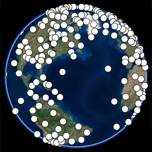
Point scene layers can efficiently display large amounts of point features. While point cloud layers can only display simple symbols, point scene layers can display any type of billboard symbol or even 3D models, as long as the location of the symbol can be described by a point. Points are cached and automatically thinned when zoomed out to improve performance.
How to use the sample
Pan around the scene and zoom in. Notice how many thousands of additional features appear at each successive zoom scale.
How it works
- Create a scene.
- Create an
ArcGISSceneLayerwith the URL to a point scene layer service. - Add the layer to the scene’s operational layers collection.
Relevant API
- ArcGISSceneLayer
About the data
This dataset contains more than 40,000 points representing world airports. Points are retrieved on demand by the scene layer as the user navigates the scene.
Additional information
Point scene layers can also be retrieved from scene layer packages (.slpk) and mobile scene packages (.mspk).
Tags
3D, point scene layer, layers
Sample code
// [WriteFile Name=AddAPointSceneLayer, Category=Scenes]// [Legal]// Copyright 2019 Esri.//// Licensed under the Apache License, Version 2.0 (the "License");// you may not use this file except in compliance with the License.// You may obtain a copy of the License at// http://www.apache.org/licenses/LICENSE-2.0//// Unless required by applicable law or agreed to in writing, software// distributed under the License is distributed on an "AS IS" BASIS,// WITHOUT WARRANTIES OR CONDITIONS OF ANY KIND, either express or implied.// See the License for the specific language governing permissions and// limitations under the License.// [Legal]
#ifdef PCH_BUILD#include "pch.hpp"#endif // PCH_BUILD
// sample headers#include "AddAPointSceneLayer.h"
// ArcGIS Maps SDK headers#include "ArcGISSceneLayer.h"#include "ArcGISTiledElevationSource.h"#include "ElevationSourceListModel.h"#include "LayerListModel.h"#include "MapTypes.h"#include "Scene.h"#include "SceneQuickView.h"#include "Surface.h"
// Qt headers#include <QUuid>
using namespace Esri::ArcGISRuntime;
AddAPointSceneLayer::AddAPointSceneLayer(QObject* parent /* = nullptr */) :  QObject(parent),  m_scene(new Scene(BasemapStyle::ArcGISImageryStandard, this)){  // create a new elevation source from Terrain3D REST service  ArcGISTiledElevationSource* elevationSource =    new ArcGISTiledElevationSource(QUrl("https://elevation3d.arcgis.com/arcgis/rest/services/WorldElevation3D/Terrain3D/ImageServer"), this);
  // add the elevation source to the scene to display elevation  m_scene->baseSurface()->elevationSources()->append(elevationSource);
  // create a new point scene layer from world airport REST service  ArcGISSceneLayer* pointSceneLayer = new ArcGISSceneLayer(    QUrl("https://tiles.arcgis.com/tiles/V6ZHFr6zdgNZuVG0/arcgis/rest/services/Airports_PointSceneLayer/SceneServer/layers/0"), this);
  // add scene layer source to the scene to display points at world airport locations  m_scene->operationalLayers()->append(pointSceneLayer);}
AddAPointSceneLayer::~AddAPointSceneLayer() = default;
void AddAPointSceneLayer::init(){  // Register classes for QML  qmlRegisterType<SceneQuickView>("Esri.Samples", 1, 0, "SceneView");  qmlRegisterType<AddAPointSceneLayer>("Esri.Samples", 1, 0, "AddAPointSceneLayerSample");}
SceneQuickView* AddAPointSceneLayer::sceneView() const{  return m_sceneView;}
// Set the view (created in QML)void AddAPointSceneLayer::setSceneView(SceneQuickView* sceneView){  if (!sceneView || sceneView == m_sceneView)  {    return;  }
  m_sceneView = sceneView;  m_sceneView->setArcGISScene(m_scene);
  emit sceneViewChanged();}
// [WriteFile Name=AddAPointSceneLayer, Category=Scenes]// [Legal]// Copyright 2019 Esri.//// Licensed under the Apache License, Version 2.0 (the "License");// you may not use this file except in compliance with the License.// You may obtain a copy of the License at// http://www.apache.org/licenses/LICENSE-2.0//// Unless required by applicable law or agreed to in writing, software// distributed under the License is distributed on an "AS IS" BASIS,// WITHOUT WARRANTIES OR CONDITIONS OF ANY KIND, either express or implied.// See the License for the specific language governing permissions and// limitations under the License.// [Legal]
#ifndef ADDAPOINTSCENELAYER_H#define ADDAPOINTSCENELAYER_H
// Qt headers#include <QObject>
namespace Esri::ArcGISRuntime{ class Scene; class SceneQuickView;} // namespace Esri::ArcGISRuntime
Q_MOC_INCLUDE("SceneQuickView.h")
class AddAPointSceneLayer : public QObject{ Q_OBJECT
Q_PROPERTY(Esri::ArcGISRuntime::SceneQuickView* sceneView READ sceneView WRITE setSceneView NOTIFY sceneViewChanged)
public: explicit AddAPointSceneLayer(QObject* parent = nullptr); ~AddAPointSceneLayer();
static void init();
signals: void sceneViewChanged();
private: Esri::ArcGISRuntime::SceneQuickView* sceneView() const; void setSceneView(Esri::ArcGISRuntime::SceneQuickView* sceneView);
Esri::ArcGISRuntime::Scene* m_scene = nullptr; Esri::ArcGISRuntime::SceneQuickView* m_sceneView = nullptr;};
#endif // ADDAPOINTSCENELAYER_H// [WriteFile Name=AddAPointSceneLayer, Category=Scenes]// [Legal]// Copyright 2019 Esri.//// Licensed under the Apache License, Version 2.0 (the "License");// you may not use this file except in compliance with the License.// You may obtain a copy of the License at// http://www.apache.org/licenses/LICENSE-2.0//// Unless required by applicable law or agreed to in writing, software// distributed under the License is distributed on an "AS IS" BASIS,// WITHOUT WARRANTIES OR CONDITIONS OF ANY KIND, either express or implied.// See the License for the specific language governing permissions and// limitations under the License.// [Legal]
import QtQuickimport QtQuick.Controlsimport Esri.Samples
Item {
SceneView { id: view anchors.fill: parent
Component.onCompleted: { // Set the focus on SceneView to initially enable keyboard navigation forceActiveFocus(); } }
// Declare the C++ instance which creates the scene etc. and supply the view AddAPointSceneLayerSample { id: model sceneView: view }}