View an integrated mesh layer from a scene service.
Use case
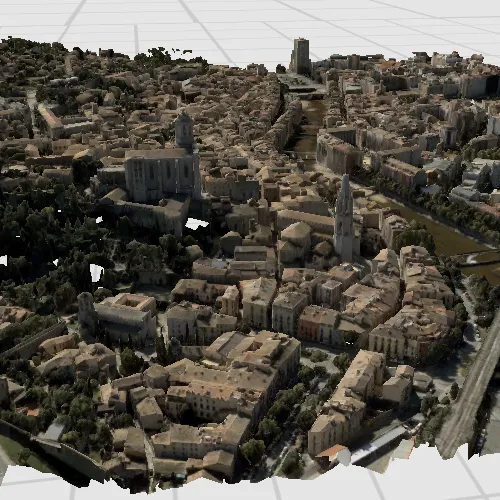
An integrated mesh is used to generate a mesh over a point dataset. They are most often used on high-density point datasets to create a high-resolution seamless surface.
How to use the sample
After launching the sample, watch the integrated mesh layer load in place. Navigate around the scene to visualize the high level of detail on the buildings.
How it works
- Create a
Scene. - Create an
IntegratedMeshLayerwith the URL to an integrated mesh layer scene service. - Add the layer to the scene’s operational layers.
Relevant API
- IntegratedMeshLayer
About the data
This integrated mesh depicts the city of Girona, Spain and is attributed to the Institut Cartogràfic i Geològic de Catalunya (ICGC). The data was produced from photogrammetrically correct imagery. Areas of white space within the integrated mesh are areas that had poor overlapping coverage from photos.
Additional information
An integrated mesh layer can also be added to a scene from a local data source - either from a scene layer package (.slpk) or a mobile scene package (.mspk).
Tags
3D, integrated mesh, layers
Sample code
// [WriteFile Name=AddIntegratedMeshLayer, Category=Scenes]// [Legal]// Copyright 2018 Esri.//// Licensed under the Apache License, Version 2.0 (the "License");// you may not use this file except in compliance with the License.// You may obtain a copy of the License at// http://www.apache.org/licenses/LICENSE-2.0//// Unless required by applicable law or agreed to in writing, software// distributed under the License is distributed on an "AS IS" BASIS,// WITHOUT WARRANTIES OR CONDITIONS OF ANY KIND, either express or implied.// See the License for the specific language governing permissions and// limitations under the License.// [Legal]
#ifdef PCH_BUILD#include "pch.hpp"#endif // PCH_BUILD
// sample headers#include "AddIntegratedMeshLayer.h"
// ArcGIS Maps SDK headers#include "Camera.h"#include "Error.h"#include "IntegratedMeshLayer.h"#include "LayerListModel.h"#include "Point.h"#include "Scene.h"#include "SceneQuickView.h"#include "SpatialReference.h"#include "Viewpoint.h"
// Qt headers#include <QUuid>
using namespace Esri::ArcGISRuntime;
AddIntegratedMeshLayer::AddIntegratedMeshLayer(QObject* parent /* = nullptr */) :  QObject(parent),  m_scene(new Scene(this)),  m_integratedMeshLyr(    new IntegratedMeshLayer(QUrl("https://tiles.arcgis.com/tiles/z2tnIkrLQ2BRzr6P/arcgis/rest/services/Girona_Spain/SceneServer"), this)){  // Connect the doneLoading signal to the handleError() method.  connect(m_integratedMeshLyr, &IntegratedMeshLayer::doneLoading, this, &AddIntegratedMeshLayer::handleError);
  m_scene->operationalLayers()->append(m_integratedMeshLyr);
  setIntegratedMeshViewpoint();}
void AddIntegratedMeshLayer::setIntegratedMeshViewpoint(){  const Point initialPt(2.8259, 41.9906, 200.0, SpatialReference::wgs84());  const Camera initialCamera(initialPt, 200.0, 190.0, 65.0, 0.0);  const Viewpoint initialViewpoint(initialPt, initialPt.z(), initialCamera);  m_scene->setInitialViewpoint(initialViewpoint);}
AddIntegratedMeshLayer::~AddIntegratedMeshLayer() = default;
void AddIntegratedMeshLayer::init(){  // Register classes for QML  qmlRegisterType<SceneQuickView>("Esri.Samples", 1, 0, "SceneView");  qmlRegisterType<AddIntegratedMeshLayer>("Esri.Samples", 1, 0, "AddIntegratedMeshLayerSample");}
SceneQuickView* AddIntegratedMeshLayer::sceneView() const{  return m_sceneView;}
// Set the view (created in QML)void AddIntegratedMeshLayer::setSceneView(SceneQuickView* sceneView){  if (!sceneView || sceneView == m_sceneView)  {    return;  }
  m_sceneView = sceneView;  m_sceneView->setArcGISScene(m_scene);
  emit sceneViewChanged();}
void AddIntegratedMeshLayer::handleError(const Error& error){  // If the doneLoading error message is not empty, an error has been encountered.  if (!error.isEmpty())  {    if (error.additionalMessage().isEmpty())    {      m_errorMessage = error.message();    }    else    {      m_errorMessage = error.message() + "\n" + error.additionalMessage();    }  }
  emit errorMessageChanged();}
// [WriteFile Name=AddIntegratedMeshLayer, Category=Scenes]// [Legal]// Copyright 2018 Esri.//// Licensed under the Apache License, Version 2.0 (the "License");// you may not use this file except in compliance with the License.// You may obtain a copy of the License at// http://www.apache.org/licenses/LICENSE-2.0//// Unless required by applicable law or agreed to in writing, software// distributed under the License is distributed on an "AS IS" BASIS,// WITHOUT WARRANTIES OR CONDITIONS OF ANY KIND, either express or implied.// See the License for the specific language governing permissions and// limitations under the License.// [Legal]
#ifndef ADDINTEGRATEDMESHLAYER_H#define ADDINTEGRATEDMESHLAYER_H
// Qt headers#include <QObject>
namespace Esri::ArcGISRuntime{ class Error; class IntegratedMeshLayer; class Scene; class SceneQuickView;} // namespace Esri::ArcGISRuntime
Q_MOC_INCLUDE("SceneQuickView.h")
class AddIntegratedMeshLayer : public QObject{ Q_OBJECT
Q_PROPERTY(Esri::ArcGISRuntime::SceneQuickView* sceneView READ sceneView WRITE setSceneView NOTIFY sceneViewChanged) Q_PROPERTY(QString errorMessage MEMBER m_errorMessage NOTIFY errorMessageChanged)
public: explicit AddIntegratedMeshLayer(QObject* parent = nullptr); ~AddIntegratedMeshLayer() override;
static void init();
signals: void sceneViewChanged(); void errorMessageChanged();
private: Esri::ArcGISRuntime::SceneQuickView* sceneView() const; void setSceneView(Esri::ArcGISRuntime::SceneQuickView* sceneView);
Esri::ArcGISRuntime::Scene* m_scene = nullptr; Esri::ArcGISRuntime::SceneQuickView* m_sceneView = nullptr; Esri::ArcGISRuntime::IntegratedMeshLayer* m_integratedMeshLyr = nullptr; QString m_errorMessage;
void handleError(const Esri::ArcGISRuntime::Error& error); void setIntegratedMeshViewpoint();};
#endif // ADDINTEGRATEDMESHLAYER_H// [WriteFile Name=AddIntegratedMeshLayer, Category=Scenes]// [Legal]// Copyright 2018 Esri.//// Licensed under the Apache License, Version 2.0 (the "License");// you may not use this file except in compliance with the License.// You may obtain a copy of the License at// http://www.apache.org/licenses/LICENSE-2.0//// Unless required by applicable law or agreed to in writing, software// distributed under the License is distributed on an "AS IS" BASIS,// WITHOUT WARRANTIES OR CONDITIONS OF ANY KIND, either express or implied.// See the License for the specific language governing permissions and// limitations under the License.// [Legal]
import QtQuickimport QtQuick.Controlsimport Esri.Samples
Item {
SceneView { id: view anchors.fill: parent
Component.onCompleted: { // Set the focus on SceneView to initially enable keyboard navigation forceActiveFocus(); } }
// Declare the C++ instance which creates the scene etc. and supply the view AddIntegratedMeshLayerSample { id: model sceneView: view }
Dialog { id: errorMessageDialog anchors.centerIn: parent visible: model.errorMessage !== "" title: qsTr("Error:") contentItem: Label { text: model.errorMessage } }}