Change a graphic’s symbol based on the camera’s proximity to it.
Use case
When showing dense datasets, it is beneficial to reduce the detail of individual points when zooming out to avoid visual clutter and to avoid data points overlapping and obscuring each other.
How to use the sample
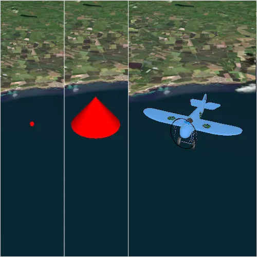
The sample starts looking at a plane. Zoom out from the plane to see it turn into a cone. Keeping zooming out and it will turn into a point.
How it works
- Create a
GraphicsOverlayobject and add it to aSceneViewobject. - Create a
DistanceCompositeSceneSymbolobject. - Create
DistanceSymbolRangeobjects specifying aSymboland the min and max distance within which the symbol should be visible. - Add the ranges to the range collection of the distance composite scene symbol.
- Create a
Graphicobject with the distance composite scene symbol at a location and add it to the graphics overlay.
Relevant API
- DistanceCompositeSceneSymbol
- Range
- RangeCollection
Offline Data
Read more about how to set up the sample’s offline data here.
| Link | Local Location |
|---|---|
| Model Marker Symbol Data | <userhome>/ArcGIS/Runtime/Data/3D/Bristol/Collada/Bristol.dae |
Tags
3D, data, graphic
Sample code
// [WriteFile Name=DistanceCompositeSymbol, Category=Scenes]// [Legal]// Copyright 2016 Esri.//// Licensed under the Apache License, Version 2.0 (the "License");// you may not use this file except in compliance with the License.// You may obtain a copy of the License at// http://www.apache.org/licenses/LICENSE-2.0//// Unless required by applicable law or agreed to in writing, software// distributed under the License is distributed on an "AS IS" BASIS,// WITHOUT WARRANTIES OR CONDITIONS OF ANY KIND, either express or implied.// See the License for the specific language governing permissions and// limitations under the License.// [Legal]
#ifdef PCH_BUILD#include "pch.hpp"#endif // PCH_BUILD
// sample headers#include "DistanceCompositeSymbol.h"
// ArcGIS Maps SDK headers#include "ArcGISTiledElevationSource.h"#include "Basemap.h"#include "DistanceCompositeSceneSymbol.h"#include "ElevationSourceListModel.h"#include "Graphic.h"#include "GraphicListModel.h"#include "GraphicsOverlay.h"#include "GraphicsOverlayListModel.h"#include "LayerSceneProperties.h"#include "MapTypes.h"#include "ModelSceneSymbol.h"#include "OrbitGeoElementCameraController.h"#include "Point.h"#include "Scene.h"#include "SceneQuickView.h"#include "SceneViewTypes.h"#include "SimpleMarkerSceneSymbol.h"#include "SimpleMarkerSymbol.h"#include "SpatialReference.h"#include "Surface.h"#include "SymbolTypes.h"
// Qt headers#include <QStandardPaths>#include <QtCore/qglobal.h>
using namespace Esri::ArcGISRuntime;
// helper method to get cross platform data pathnamespace{  QString defaultDataPath()  {    QString dataPath;
#ifdef Q_OS_IOS    dataPath = QStandardPaths::writableLocation(QStandardPaths::DocumentsLocation);#else    dataPath = QStandardPaths::writableLocation(QStandardPaths::HomeLocation);#endif
    return dataPath;  }} // namespace
DistanceCompositeSymbol::DistanceCompositeSymbol(QQuickItem* parent) :  QQuickItem(parent){}
DistanceCompositeSymbol::~DistanceCompositeSymbol() = default;
void DistanceCompositeSymbol::init(){  qmlRegisterType<SceneQuickView>("Esri.Samples", 1, 0, "SceneView");  qmlRegisterType<DistanceCompositeSymbol>("Esri.Samples", 1, 0, "DistanceCompositeSymbolSample");}
void DistanceCompositeSymbol::componentComplete(){  QQuickItem::componentComplete();
  // get the data path  const QString dataPath = defaultDataPath() + "/ArcGIS/Runtime/Data/3D/Bristol/Collada/Bristol.dae";
  // find QML SceneView component  m_sceneView = findChild<SceneQuickView*>("sceneView");
  // create a new basemap instance  Basemap* basemap = new Basemap(BasemapStyle::ArcGISImageryStandard, this);  // create a new scene instance  m_scene = new Scene(basemap, this);  // set scene on the scene view  m_sceneView->setArcGISScene(m_scene);
  // create a new elevation source  ArcGISTiledElevationSource* elevationSource =    new ArcGISTiledElevationSource(QUrl("https://elevation3d.arcgis.com/arcgis/rest/services/WorldElevation3D/Terrain3D/ImageServer"), this);  // add the elevation source to the scene to display elevation  m_scene->baseSurface()->elevationSources()->append(elevationSource);
  // create a camera  const Point point(-2.708471, 56.096575, 5000, m_sceneView->spatialReference());
  // create a new graphics overlay and add it to the sceneview  GraphicsOverlay* graphicsOverlay = new GraphicsOverlay(this);  graphicsOverlay->setSceneProperties(LayerSceneProperties(SurfacePlacement::Relative));  m_sceneView->graphicsOverlays()->append(graphicsOverlay);
  //! [create model scene symbol]  constexpr float scale = 5.0f;  ModelSceneSymbol* mms = new ModelSceneSymbol(QUrl(dataPath), scale, this);  mms->setHeading(180);  //! [create model scene symbol]
  connect(mms, &ModelSceneSymbol::loadStatusChanged, this, [mms, point, graphicsOverlay, this]()  {    if (mms->loadStatus() == LoadStatus::Loaded)    {      SimpleMarkerSymbol* sms = new SimpleMarkerSymbol(SimpleMarkerSymbolStyle::Circle, QColor("red"), 10.0f, this);      //! [create simple marker scene symbol]      const SimpleMarkerSceneSymbolStyle style = SimpleMarkerSceneSymbolStyle::Cone;      const QColor color("red");      constexpr double height = 75.0;      constexpr double width = 75.0;      constexpr double depth = 75.0;      const SceneSymbolAnchorPosition anchorPosition = SceneSymbolAnchorPosition::Bottom;      SimpleMarkerSceneSymbol* smss = new SimpleMarkerSceneSymbol(style, color, height, width, depth, anchorPosition, this);      //! [create simple marker scene symbol]
      //! [create distance symbol ranges with each symbol type and a distance range(meters)]      DistanceSymbolRange* dsrModel = new DistanceSymbolRange(mms, 0, 999, this); // ModelSceneSymbol      DistanceSymbolRange* dsrCone = new DistanceSymbolRange(smss, 1000, 1999, this); // SimpleMarkerSceneSymbol      DistanceSymbolRange* dsrCircle = new DistanceSymbolRange(sms, 2000, 0, this); // SimpleMarkerSymbol
      DistanceCompositeSceneSymbol* compositeSceneSymbol = new DistanceCompositeSceneSymbol(this);
      compositeSceneSymbol->ranges()->append(dsrModel);      compositeSceneSymbol->ranges()->append(dsrCone);      compositeSceneSymbol->ranges()->append(dsrCircle);      //! [create distance symbol ranges with each symbol type and a distance range(meters)]
      // create a graphic using the composite symbol      Graphic* graphic = new Graphic(point, compositeSceneSymbol, this);
      // add the graphic to the graphics overlay      graphicsOverlay->graphics()->append(graphic);
      // add an orbit camera controller to lock the camera to the graphic      OrbitGeoElementCameraController* cameraController = new OrbitGeoElementCameraController(graphic, 200, this);      cameraController->setCameraPitchOffset(80);      cameraController->setCameraHeadingOffset(-30);      m_sceneView->setCameraController(cameraController);    }  });
  mms->load();}
// [WriteFile Name=DistanceCompositeSymbol, Category=Scenes]// [Legal]// Copyright 2016 Esri.//// Licensed under the Apache License, Version 2.0 (the "License");// you may not use this file except in compliance with the License.// You may obtain a copy of the License at// http://www.apache.org/licenses/LICENSE-2.0//// Unless required by applicable law or agreed to in writing, software// distributed under the License is distributed on an "AS IS" BASIS,// WITHOUT WARRANTIES OR CONDITIONS OF ANY KIND, either express or implied.// See the License for the specific language governing permissions and// limitations under the License.// [Legal]
#ifndef DISTANCE_COMPOSITE_SYMBOL_H#define DISTANCE_COMPOSITE_SYMBOL_H
// Qt headers#include <QQuickItem>
namespace Esri::ArcGISRuntime{ class Scene; class SceneQuickView;} // namespace Esri::ArcGISRuntime
class DistanceCompositeSymbol : public QQuickItem{ Q_OBJECT
public: explicit DistanceCompositeSymbol(QQuickItem* parent = nullptr); ~DistanceCompositeSymbol() override;
void componentComplete() override; static void init();
private: Esri::ArcGISRuntime::Scene* m_scene = nullptr; Esri::ArcGISRuntime::SceneQuickView* m_sceneView = nullptr;};
#endif // DISTANCE_COMPOSITE_SYMBOL_H// [WriteFile Name=DistanceCompositeSymbol, Category=Scenes]// [Legal]// Copyright 2016 Esri.//// Licensed under the Apache License, Version 2.0 (the "License");// you may not use this file except in compliance with the License.// You may obtain a copy of the License at// http://www.apache.org/licenses/LICENSE-2.0//// Unless required by applicable law or agreed to in writing, software// distributed under the License is distributed on an "AS IS" BASIS,// WITHOUT WARRANTIES OR CONDITIONS OF ANY KIND, either express or implied.// See the License for the specific language governing permissions and// limitations under the License.// [Legal]
import QtQuickimport Esri.Samples
DistanceCompositeSymbolSample { width: 800 height: 600
// add a mapView component SceneView { anchors.fill: parent objectName: "sceneView"
Component.onCompleted: { // Set the focus on SceneView to initially enable keyboard navigation forceActiveFocus(); } }}