Edit the values of a KML ground overlay.
Use case
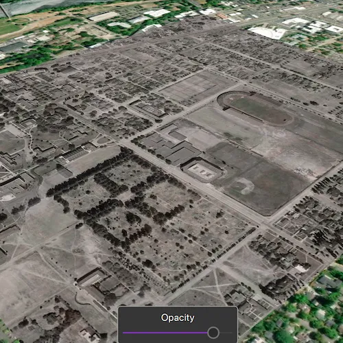
KML ground overlays are used for showing aerial imagery, symbology, or other images draped over a scene. Changing the geometry, rotation, and other attributes of a ground overlay after it has been loaded allows for live editing. For example, editing the geometry and opacity of a historical image draped over present day satellite imagery makes it possible to view change over time.
How to use the sample
Use the slider to adjust the opacity of the ground overlay.
How it works
- Create an
Envelopedefining the geometry of the overlay. - Create a
KmlIconusing aUrllinking to an image. - Create a
KmlGroundOverlayusing the envelope and icon. - Set the value of
KmlGroundOverlay::rotation. - Create a
KmlDatasetusing the ground overlay. - Create a
KmlLayerusing the dataset. - Add the KML layer to the scene.
- Listen for changes to the opacity slider and change the
KmlGroundOverlay::colorvalue appropriately.
Relevant API
- KmlDataset
- KmlGroundOverlay
- KmlIcon
- KmlLayer
About the data
The image used in this sample is an aerial view of the campus of the University of Oregon. This imagery was taken in 1944 by the U.S. Army Corps of Engineers. It is publicly available as Online Aerial Imagery hosted by Oregon University Library. It is also available as a Portal item on ArcGIS Online as University of Oregon Campus Aerial Imagery - 1944.
Tags
imagery, keyhole, KML, KMZ, OGC
Sample code
// [WriteFile Name=EditKmlGroundOverlay, Category=EditData]// [Legal]// Copyright 2019 Esri.//// Licensed under the Apache License, Version 2.0 (the "License");// you may not use this file except in compliance with the License.// You may obtain a copy of the License at// http://www.apache.org/licenses/LICENSE-2.0//// Unless required by applicable law or agreed to in writing, software// distributed under the License is distributed on an "AS IS" BASIS,// WITHOUT WARRANTIES OR CONDITIONS OF ANY KIND, either express or implied.// See the License for the specific language governing permissions and// limitations under the License.// [Legal]
#ifdef PCH_BUILD#include "pch.hpp"#endif // PCH_BUILD
// sample headers#include "EditKmlGroundOverlay.h"
// ArcGIS Maps SDK headers#include "Camera.h"#include "Envelope.h"#include "Error.h"#include "KmlDataset.h"#include "KmlGroundOverlay.h"#include "KmlIcon.h"#include "KmlLayer.h"#include "LayerListModel.h"#include "MapTypes.h"#include "Point.h"#include "Scene.h"#include "SceneQuickView.h"#include "SpatialReference.h"
// Qt headers#include <QFuture>#include <QStandardPaths>#include <QtCore/qglobal.h>
using namespace Esri::ArcGISRuntime;
// helper method to get cross platform data pathnamespace{  QString defaultDataPath()  {    QString dataPath;
#ifdef Q_OS_IOS    dataPath = QStandardPaths::writableLocation(QStandardPaths::DocumentsLocation);#else    dataPath = QStandardPaths::writableLocation(QStandardPaths::HomeLocation);#endif
    return dataPath;  }} // namespace
EditKmlGroundOverlay::EditKmlGroundOverlay(QObject* parent /* = nullptr */) :  QObject(parent),  m_scene(new Scene(BasemapStyle::ArcGISImageryStandard, this)){  // Create Geometry  const Envelope env(-123.066227926904, 44.04736963555683, -123.0796942287304, 44.03878298600624, SpatialReference(4326));
  // Create KML Icon  KmlIcon* kmlIcon = new KmlIcon(QUrl(defaultDataPath() + "/ArcGIS/Runtime/Data/raster/1944.jpg"), this);
  // Create Ground Overlay  m_groundOverlay = new KmlGroundOverlay(env, kmlIcon, this);  m_groundOverlay->setRotation(-3.046024799346924);
  // Create Dataset  KmlDataset* kmlDataset = new KmlDataset(m_groundOverlay, this);
  // Create Layer  KmlLayer* kmlLayer = new KmlLayer(kmlDataset, this);
  // Connect to know when the layer loads  connect(kmlLayer, &KmlLayer::doneLoading, this, [this, env](const Error& e)  {    if (!e.isEmpty() || !m_sceneView)    {      return;    }
    const Camera camera(env.center(), 1250, 45, 60, 0);    m_sceneView->setViewpointCameraAsync(camera);  });  m_scene->operationalLayers()->append(kmlLayer);}
EditKmlGroundOverlay::~EditKmlGroundOverlay() = default;
void EditKmlGroundOverlay::init(){  // Register classes for QML  qmlRegisterType<SceneQuickView>("Esri.Samples", 1, 0, "SceneView");  qmlRegisterType<EditKmlGroundOverlay>("Esri.Samples", 1, 0, "EditKmlGroundOverlaySample");}
void EditKmlGroundOverlay::setOpacity(int opacity){  if (!m_groundOverlay)  {    return;  }
  m_groundOverlay->setColor(QColor(0, 0, 0, opacity));}
SceneQuickView* EditKmlGroundOverlay::sceneView() const{  return m_sceneView;}
// Set the view (created in QML)void EditKmlGroundOverlay::setSceneView(SceneQuickView* sceneView){  if (!sceneView || sceneView == m_sceneView)  {    return;  }
  m_sceneView = sceneView;  m_sceneView->setArcGISScene(m_scene);
  emit sceneViewChanged();}
// [WriteFile Name=EditKmlGroundOverlay, Category=EditData]// [Legal]// Copyright 2019 Esri.//// Licensed under the Apache License, Version 2.0 (the "License");// you may not use this file except in compliance with the License.// You may obtain a copy of the License at// http://www.apache.org/licenses/LICENSE-2.0//// Unless required by applicable law or agreed to in writing, software// distributed under the License is distributed on an "AS IS" BASIS,// WITHOUT WARRANTIES OR CONDITIONS OF ANY KIND, either express or implied.// See the License for the specific language governing permissions and// limitations under the License.// [Legal]
#ifndef EDITKMLGROUNDOVERLAY_H#define EDITKMLGROUNDOVERLAY_H
// Qt headers#include <QObject>
namespace Esri::ArcGISRuntime{ class Scene; class SceneQuickView; class KmlGroundOverlay;} // namespace Esri::ArcGISRuntime
Q_MOC_INCLUDE("SceneQuickView.h")
class EditKmlGroundOverlay : public QObject{ Q_OBJECT
Q_PROPERTY(Esri::ArcGISRuntime::SceneQuickView* sceneView READ sceneView WRITE setSceneView NOTIFY sceneViewChanged)
public: explicit EditKmlGroundOverlay(QObject* parent = nullptr); ~EditKmlGroundOverlay();
static void init(); Q_INVOKABLE void setOpacity(int opacity);
signals: void sceneViewChanged();
private: Esri::ArcGISRuntime::SceneQuickView* sceneView() const; void setSceneView(Esri::ArcGISRuntime::SceneQuickView* sceneView);
Esri::ArcGISRuntime::Scene* m_scene = nullptr; Esri::ArcGISRuntime::SceneQuickView* m_sceneView = nullptr; Esri::ArcGISRuntime::KmlGroundOverlay* m_groundOverlay = nullptr;};
#endif // EDITKMLGROUNDOVERLAY_H// [WriteFile Name=EditKmlGroundOverlay, Category=EditData]// [Legal]// Copyright 2019 Esri.//// Licensed under the Apache License, Version 2.0 (the "License");// you may not use this file except in compliance with the License.// You may obtain a copy of the License at// http://www.apache.org/licenses/LICENSE-2.0//// Unless required by applicable law or agreed to in writing, software// distributed under the License is distributed on an "AS IS" BASIS,// WITHOUT WARRANTIES OR CONDITIONS OF ANY KIND, either express or implied.// See the License for the specific language governing permissions and// limitations under the License.// [Legal]
import QtQuickimport QtQuick.Controlsimport Esri.Samples
Item {
SceneView { id: view anchors.fill: parent
Component.onCompleted: { // Set the focus on SceneView to initially enable keyboard navigation forceActiveFocus(); }
// Slider UI presentation at bottom Rectangle { anchors { horizontalCenter: parent.horizontalCenter bottom: view.attributionTop } width: childrenRect.width height: childrenRect.height radius: 5 color: palette.base border { width: 1 color: "darkgrey" }
Column { padding: 8 spacing: 5
Label { anchors { horizontalCenter: parent.horizontalCenter } text: "Opacity" }
// sliderCombo: A slider and text for its value Row { id: sliderCombo
Slider { id: slider anchors { verticalCenter: parent.verticalCenter } // Slider controls degrees of rotation from: 0 to: 255 value: 255 stepSize: 25 onValueChanged: { // modify the overlay's color/alpha value model.setOpacity(value); } } } } } }
// Declare the C++ instance which creates the scene etc. and supply the view EditKmlGroundOverlaySample { id: model sceneView: view }}