Display a raster contained in a GeoPackage.
Use case
GeoPackages are designed to simplify file management and transfer. They can store raster files (as well as other types of data). An end-user wishing to transfer rasters from ArcGIS Pro or between ArcGIS Maps SDK apps, might need to import raster files from GeoPackages into their map to view and analyze the data.
How to use the sample
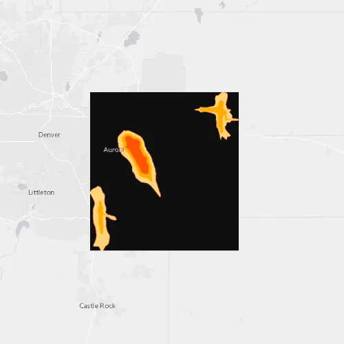
When the sample starts, a raster will be loaded from a GeoPackage and displayed in the map view.
How it works
- Create and load a
GeoPackage, specifying the path to the local .gpkg file. - When it is done loading, get the
GeoPackageRasters from the geopackage. - Construct a
RasterLayerwith the geopackage raster you want to use. - Add the raster layer to the map.
Relevant API
- GeoPackage
- GeoPackageRaster
- RasterLayer
Offline Data
Read more about how to set up the sample’s offline data here.
| Link | Local Location |
|---|---|
| Aurora, Colorado GeoPackage | <userhome>/ArcGIS/Runtime/Data/gpkg/AuroraCO.gpkg |
About the data
The Aurora Colorado GeoPackage holds datasets that cover Aurora, Colorado. The raster that is opened and displayed shows airport noise levels.
Tags
container, data, image, import, layer, OGC, package, raster, visualization
Sample code
// [WriteFile Name=RasterLayerGeoPackage, Category=Layers]// [Legal]// Copyright 2017 Esri.//// Licensed under the Apache License, Version 2.0 (the "License");// you may not use this file except in compliance with the License.// You may obtain a copy of the License at// http://www.apache.org/licenses/LICENSE-2.0//// Unless required by applicable law or agreed to in writing, software// distributed under the License is distributed on an "AS IS" BASIS,// WITHOUT WARRANTIES OR CONDITIONS OF ANY KIND, either express or implied.// See the License for the specific language governing permissions and// limitations under the License.// [Legal]
#ifdef PCH_BUILD#include "pch.hpp"#endif // PCH_BUILD
// sample headers#include "RasterLayerGeoPackage.h"
// ArcGIS Maps SDK headers#include "Error.h"#include "GeoPackage.h"#include "GeoPackageRaster.h"#include "LayerListModel.h"#include "Map.h"#include "MapQuickView.h"#include "MapTypes.h"#include "Point.h"#include "RasterLayer.h"#include "SpatialReference.h"#include "Viewpoint.h"
// Qt headers#include <QStandardPaths>#include <QUrl>#include <QtCore/qglobal.h>
using namespace Esri::ArcGISRuntime;
// helper method to get cross platform data pathnamespace{  QString defaultDataPath()  {    QString dataPath;
#ifdef Q_OS_IOS    dataPath = QStandardPaths::writableLocation(QStandardPaths::DocumentsLocation);#else    dataPath = QStandardPaths::writableLocation(QStandardPaths::HomeLocation);#endif
    return dataPath;  }} // namespace
RasterLayerGeoPackage::RasterLayerGeoPackage(QQuickItem* parent /* = nullptr */) :  QQuickItem(parent){}
void RasterLayerGeoPackage::init(){  // Register the map view for QML  qmlRegisterType<MapQuickView>("Esri.Samples", 1, 0, "MapView");  qmlRegisterType<RasterLayerGeoPackage>("Esri.Samples", 1, 0, "RasterLayerGeoPackageSample");}
void RasterLayerGeoPackage::componentComplete(){  QQuickItem::componentComplete();
  // find QML MapView component  m_mapView = findChild<MapQuickView*>("mapView");
  // Create a map using the light gray basemap  m_map = new Map(BasemapStyle::ArcGISLightGray, this);
  // Set an initial viewpoint  const Point pt(-104.8319, 39.7294, SpatialReference(4326));  const Viewpoint vp(pt, 200000);  m_map->setInitialViewpoint(vp);
  // Create the GeoPackage  const QString dataPath = defaultDataPath() + "/ArcGIS/Runtime/Data/gpkg/";  GeoPackage* gpkg = new GeoPackage(dataPath + "AuroraCO.gpkg", this);
  // Connect to GeoPackage::doneLoading  connect(gpkg, &GeoPackage::doneLoading, this, [this, gpkg](const Error& e)  {    if (!e.isEmpty())    {      return;    }
    if (!(gpkg->geoPackageRasters().size() > 0))    {      return;    }
    GeoPackageRaster* gpkgRaster = gpkg->geoPackageRasters().at(0);    RasterLayer* rasterLayer = new RasterLayer(gpkgRaster, this);    m_map->operationalLayers()->append(rasterLayer);  });
  // Connect to Map::doneLoading  connect(m_map, &Map::doneLoading, this, [gpkg](const Error& e)  {    if (!e.isEmpty())    {      return;    }
    // load the GeoPackage    gpkg->load();  });
  // Set map to map view  m_mapView->setMap(m_map);}
// [WriteFile Name=RasterLayerGeoPackage, Category=Layers]// [Legal]// Copyright 2017 Esri.//// Licensed under the Apache License, Version 2.0 (the "License");// you may not use this file except in compliance with the License.// You may obtain a copy of the License at// http://www.apache.org/licenses/LICENSE-2.0//// Unless required by applicable law or agreed to in writing, software// distributed under the License is distributed on an "AS IS" BASIS,// WITHOUT WARRANTIES OR CONDITIONS OF ANY KIND, either express or implied.// See the License for the specific language governing permissions and// limitations under the License.// [Legal]
#ifndef RASTERLAYERGEOPACKAGE_H#define RASTERLAYERGEOPACKAGE_H
// Qt headers#include <QQuickItem>
namespace Esri::ArcGISRuntime{ class Map; class MapQuickView;} // namespace Esri::ArcGISRuntime
class RasterLayerGeoPackage : public QQuickItem{ Q_OBJECT
public: explicit RasterLayerGeoPackage(QQuickItem* parent = nullptr); ~RasterLayerGeoPackage() override = default;
void componentComplete() override; static void init();
private: Esri::ArcGISRuntime::Map* m_map = nullptr; Esri::ArcGISRuntime::MapQuickView* m_mapView = nullptr;};
#endif // RASTERLAYERGEOPACKAGE_H// [WriteFile Name=RasterLayerGeoPackage, Category=Layers]// [Legal]// Copyright 2017 Esri.//// Licensed under the Apache License, Version 2.0 (the "License");// you may not use this file except in compliance with the License.// You may obtain a copy of the License at// http://www.apache.org/licenses/LICENSE-2.0//// Unless required by applicable law or agreed to in writing, software// distributed under the License is distributed on an "AS IS" BASIS,// WITHOUT WARRANTIES OR CONDITIONS OF ANY KIND, either express or implied.// See the License for the specific language governing permissions and// limitations under the License.// [Legal]
import QtQuickimport Esri.Samples
RasterLayerGeoPackageSample { id: rootRectangle clip: true width: 800 height: 600
// add a mapView component MapView { anchors.fill: parent objectName: "mapView"
Component.onCompleted: { // Set the focus on MapView to initially enable keyboard navigation forceActiveFocus(); } }}