Display KML from a URL, portal item, or local KML file.
Use case
Keyhole Markup Language (KML) is a data format used by Google Earth. KML is popular as a transmission format for consumer use and for sharing geographic data between apps. You can use the ArcGIS Maps SDK for Native Apps to display KML files, with full support for a variety of features, including network links, 3D models, screen overlays, and tours.
How to use the sample
Use the drop-down menu to select a source. A KML file from that source will be loaded and displayed in the map.
How it works
- To create a KML layer from a URL, create a
KmlDatasetusing the URL to the KML file. Then pass the dataset to theKmlLayerconstructor. - To create a KML layer from a portal item, construct a
PortalItemwith aPortaland the KML portal item ID. Pass the portal item to theKmlLayerconstructor. - To create a KML layer from a local file, create a
KmlDatasetusing the absolute file path to the local KML file. Then pass the dataset to theKmlLayerconstructor. - Add the layer as an operational layer to the map with
map::operationalLayers()::append(kmlLayer).
Relevant API
- KmlDataset
- KmlLayer
Offline data
To set up the sample’s offline data, see the Use offline data in the samples section of the Qt Samples repository overview.
| Link | Local Location |
|---|---|
| US State Capitals | <userhome>/ArcGIS/Runtime/Data/kml/US_State_Capitals.kml |
About the data
This sample displays three different KML files:
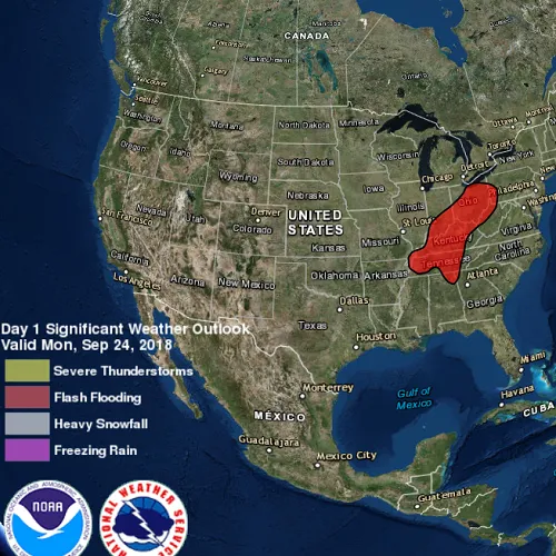
- From URL - this is a map of the convective outlook produced by NOAA/NWS Storm Prediction Center. It uses KML network links to always show the latest data.
- From local file - this is a map of U.S. state capitals. It doesn’t define an icon, so the default pushpin is used for the points.
- From portal item - this is a map of U.S. states.
Tags
keyhole, KML, KMZ, OGC
Sample code
// [WriteFile Name=DisplayKml, Category=Layers]// [Legal]// Copyright 2018 Esri.//// Licensed under the Apache License, Version 2.0 (the "License");// you may not use this file except in compliance with the License.// You may obtain a copy of the License at// http://www.apache.org/licenses/LICENSE-2.0//// Unless required by applicable law or agreed to in writing, software// distributed under the License is distributed on an "AS IS" BASIS,// WITHOUT WARRANTIES OR CONDITIONS OF ANY KIND, either express or implied.// See the License for the specific language governing permissions and// limitations under the License.// [Legal]
#ifdef PCH_BUILD#include "pch.hpp"#endif // PCH_BUILD
// sample headers#include "DisplayKml.h"
// ArcGIS Maps SDK headers#include "ArcGISTiledElevationSource.h"#include "Camera.h"#include "ElevationSourceListModel.h"#include "KmlDataset.h"#include "KmlLayer.h"#include "LayerListModel.h"#include "MapTypes.h"#include "Point.h"#include "PortalItem.h"#include "Scene.h"#include "SceneQuickView.h"#include "SpatialReference.h"#include "Surface.h"#include "Viewpoint.h"
// Qt headers#include <QFuture>#include <QStandardPaths>#include <QtCore/qglobal.h>
using namespace Esri::ArcGISRuntime;
// helper method to get cross platform data pathnamespace{  QString defaultDataPath()  {    QString dataPath;
#ifdef Q_OS_IOS    dataPath = QStandardPaths::writableLocation(QStandardPaths::DocumentsLocation);#else    dataPath = QStandardPaths::writableLocation(QStandardPaths::HomeLocation);#endif
    return dataPath;  }} // namespace
DisplayKml::DisplayKml(QQuickItem* parent /* = nullptr */) :  QQuickItem(parent){}
DisplayKml::~DisplayKml() = default;
void DisplayKml::init(){  // Register classes for QML  qmlRegisterType<SceneQuickView>("Esri.Samples", 1, 0, "SceneView");  qmlRegisterType<DisplayKml>("Esri.Samples", 1, 0, "DisplayKmlSample");}
void DisplayKml::componentComplete(){  QQuickItem::componentComplete();
  // Create a scene and give it to the SceneView  m_sceneView = findChild<SceneQuickView*>("sceneView");  m_scene = new Scene(BasemapStyle::ArcGISImagery, this);  Surface* surface = new Surface(this);  surface->elevationSources()->append(    new ArcGISTiledElevationSource(QUrl("https://elevation3d.arcgis.com/arcgis/rest/services/WorldElevation3D/Terrain3D/ImageServer"), this));  m_scene->setBaseSurface(surface);  m_sceneView->setArcGISScene(m_scene);
  // Create a viewpoint  const Point pt(-98, 39, SpatialReference::wgs84());  constexpr int scale = 10000000;  const Camera camera(pt, scale, 0, 0, 0);  m_viewpoint = Viewpoint(pt, scale, camera);}
void DisplayKml::createFromUrl(){  clearLayers();
  // Create the Dataset from an Online URL  m_kmlDataset = new KmlDataset(QUrl("https://www.wpc.ncep.noaa.gov/kml/noaa_chart/WPC_Day1_SigWx_latest.kml"), this);
  // Create the Layer  m_kmlLayer = new KmlLayer(m_kmlDataset, this);
  // Add the layer to the scene  addLayerToScene(m_kmlLayer);}
void DisplayKml::createFromFile(){  clearLayers();
  // Create the Dataset from a local file  const QString dataPath = defaultDataPath() + "/ArcGIS/Runtime/Data/kml/";  m_kmlDataset = new KmlDataset(QUrl(dataPath + "US_State_Capitals.kml"), this);
  // Create the Layer  m_kmlLayer = new KmlLayer(m_kmlDataset, this);
  // Add the layer to the scene  addLayerToScene(m_kmlLayer);}
void DisplayKml::createFromPortalItem(){  clearLayers();
  // Create the PortalItem  m_portalItem = new PortalItem(QStringLiteral("9fe0b1bfdcd64c83bd77ea0452c76253"), this);
  // Create the Layer  m_kmlLayer = new KmlLayer(m_portalItem, this);
  // Add the layer to the scene  addLayerToScene(m_kmlLayer);}
void DisplayKml::addLayerToScene(KmlLayer* layer){  if (!m_scene)  {    return;  }
  m_scene->operationalLayers()->append(layer);
  if (m_viewpoint.isEmpty())  {    return;  }
  m_sceneView->setViewpointAsync(m_viewpoint);}
void DisplayKml::clearLayers(){  if (!m_scene)  {    return;  }
  // remove the layers  m_scene->operationalLayers()->clear();
  // clean up the kml datasets  if (m_kmlDataset)  {    delete m_kmlDataset;    m_kmlDataset = nullptr;  }
  // clean up the portal items  if (m_portalItem)  {    delete m_portalItem;    m_portalItem = nullptr;  }
  // clean up the kml layers  if (m_kmlLayer)  {    delete m_kmlLayer;    m_kmlLayer = nullptr;  }}
// [WriteFile Name=DisplayKml, Category=Layers]// [Legal]// Copyright 2018 Esri.//// Licensed under the Apache License, Version 2.0 (the "License");// you may not use this file except in compliance with the License.// You may obtain a copy of the License at// http://www.apache.org/licenses/LICENSE-2.0//// Unless required by applicable law or agreed to in writing, software// distributed under the License is distributed on an "AS IS" BASIS,// WITHOUT WARRANTIES OR CONDITIONS OF ANY KIND, either express or implied.// See the License for the specific language governing permissions and// limitations under the License.// [Legal]
#ifndef DISPLAYKML_H#define DISPLAYKML_H
// ArcGIS Maps SDK headers#include "Viewpoint.h"
// Qt headers#include <QQuickItem>
namespace Esri::ArcGISRuntime{ class SceneQuickView; class Scene; class KmlLayer; class KmlDataset; class PortalItem;} // namespace Esri::ArcGISRuntime
class DisplayKml : public QQuickItem{ Q_OBJECT
public: explicit DisplayKml(QQuickItem* parent = nullptr); ~DisplayKml() override;
void componentComplete() override; static void init();
Q_INVOKABLE void createFromUrl(); Q_INVOKABLE void createFromFile(); Q_INVOKABLE void createFromPortalItem();
private: Esri::ArcGISRuntime::SceneQuickView* m_sceneView = nullptr; Esri::ArcGISRuntime::Scene* m_scene = nullptr; Esri::ArcGISRuntime::Viewpoint m_viewpoint; Esri::ArcGISRuntime::KmlDataset* m_kmlDataset = nullptr; Esri::ArcGISRuntime::KmlLayer* m_kmlLayer = nullptr; Esri::ArcGISRuntime::PortalItem* m_portalItem = nullptr;
void addLayerToScene(Esri::ArcGISRuntime::KmlLayer* layer); void clearLayers();};
#endif // DISPLAYKML_H// [WriteFile Name=DisplayKml, Category=Layers]// [Legal]// Copyright 2018 Esri.//// Licensed under the Apache License, Version 2.0 (the "License");// you may not use this file except in compliance with the License.// You may obtain a copy of the License at// http://www.apache.org/licenses/LICENSE-2.0//// Unless required by applicable law or agreed to in writing, software// distributed under the License is distributed on an "AS IS" BASIS,// WITHOUT WARRANTIES OR CONDITIONS OF ANY KIND, either express or implied.// See the License for the specific language governing permissions and// limitations under the License.// [Legal]
import QtQuickimport QtQuick.Controlsimport Esri.Samples
DisplayKmlSample { id: rootRectangle clip: true width: 800 height: 600
SceneView { objectName: "sceneView" anchors.fill: parent
Component.onCompleted: { // Set the focus on SceneView to initially enable keyboard navigation forceActiveFocus(); } }
ComboBox { id: comboBox anchors { right: parent.right top: parent.top margins: 5 }
property int modelWidth: 0 width: modelWidth + leftPadding + rightPadding + (indicator ? indicator.width : 10) + 32
model: ["URL", "Local file", "Portal Item"]
onCurrentIndexChanged: { // create the Layer if (currentIndex === 0) createFromUrl(); else if (currentIndex === 1) createFromFile(); else createFromPortalItem(); }
Component.onCompleted : { for (let i = 0; i < model.length; ++i) { metrics.text = model[i]; modelWidth = Math.max(modelWidth, metrics.width); } currentIndexChanged(); }
TextMetrics { id: metrics font: comboBox.font } }}