Demonstrates how to animate a graphic’s position and rotation and follow it using a OrbitGeoElementCameraController.
Also shows how to combine a SceneView and MapView in an MVC application with property binding.
Use case
Visualize movement through a 3D landscape.
How to use the sample
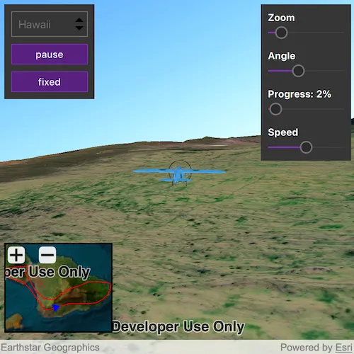
Animation Controls (Top Left Corner):
- Select a mission — selects a location with a route for the plane to fly
- Play/Pause — toggles playing and stopping the animation
- Fixed/Follow — toggles the camera’s free cam mode and follow
- Mission progress — shows how far along the route the plane is. Slide to change keyframe in animation
Camera Controls (Top Right Corner):
- Camare zoom — distance between camera and plane
- Camera angle — viewing angle between camera and plane
- Flight speed — controls speed of animation
2D Map Controls (Bottom Left Corner):
- Plus and Minus — controls distance of 2D view from ground level
How it works
- Create a
GraphicsOverlayand add it to theSceneView. - Create a
ModelSceneSymbolobject. - Create a
Graphicobject and set its geometry to aPoint. - Set the
ModelSceneSymbolobject to the graphic. - Add heading, pitch, and roll attributes to the graphic. Get the attributes from the graphic with
Graphic::attributes. - Create a
SimpleRendererobject and set its expression properties. - Add graphic and a renderer to the graphics overlay.
- Create a
OrbitGeoElementCameraControllerwhich is set to target the graphic. - Assign the camera controller to the
SceneView. - Update the graphic’s location, heading, pitch, and roll.
Relevant API
- Camera
- GlobeCameraController
- Graphic
- GraphicsOverlay
- ModelSceneSymbol
- OrbitGeoElementCameraController
- Renderer
- Scene
- SceneProperties
- SceneView
- SurfacePlacement
Offline Data
Read more about how to set up the sample’s offline data here.
| Link | Local Location |
|---|---|
| Model Marker Symbol Data | <userhome>/ArcGIS/Runtime/Data/3D/Bristol/Collada/Bristol.dae |
| GrandCanyon.csv mission data | <userhome>/ArcGIS/Runtime/Data/3D/Missions/GrandCanyon.csv |
| Hawaii.csv mission data | <userhome>/ArcGIS/Runtime/Data/3D/Missions/Hawaii.csv |
| Pyrenees.csv mission data | <userhome>/ArcGIS/Runtime/Data/3D/Missions/Pyrenees.csv |
| Snowdon.csv mission data | <userhome>/ArcGIS/Runtime/Data/3D/Missions/Snowdon.csv |
Tags
animation, camera, heading, pitch, roll, rotation, visualize
Sample code
// [WriteFile Name=Animate3DSymbols, Category=Scenes]// [Legal]// Copyright 2016 Esri.//// Licensed under the Apache License, Version 2.0 (the "License");// you may not use this file except in compliance with the License.// You may obtain a copy of the License at// http://www.apache.org/licenses/LICENSE-2.0//// Unless required by applicable law or agreed to in writing, software// distributed under the License is distributed on an "AS IS" BASIS,// WITHOUT WARRANTIES OR CONDITIONS OF ANY KIND, either express or implied.// See the License for the specific language governing permissions and// limitations under the License.// [Legal]
#ifdef PCH_BUILD#include "pch.hpp"#endif // PCH_BUILD
// sample headers#include "Animate3DSymbols.h"#include "MissionData.h"
// ArcGIS Maps SDK headers#include "ArcGISTiledElevationSource.h"#include "AttributeListModel.h"#include "Camera.h"#include "DistanceCompositeSceneSymbol.h"#include "ElevationSourceListModel.h"#include "GlobeCameraController.h"#include "Graphic.h"#include "GraphicListModel.h"#include "GraphicsOverlay.h"#include "GraphicsOverlayListModel.h"#include "LayerSceneProperties.h"#include "Map.h"#include "MapQuickView.h"#include "MapTypes.h"#include "ModelSceneSymbol.h"#include "OrbitGeoElementCameraController.h"#include "PointCollection.h"#include "Polyline.h"#include "PolylineBuilder.h"#include "RendererSceneProperties.h"#include "Scene.h"#include "SceneQuickView.h"#include "SceneViewTypes.h"#include "SimpleLineSymbol.h"#include "SimpleMarkerSceneSymbol.h"#include "SimpleMarkerSymbol.h"#include "SimpleRenderer.h"#include "SpatialReference.h"#include "Surface.h"#include "SymbolTypes.h"#include "Viewpoint.h"
// Qt headers#include <QFileInfo>#include <QFuture>#include <QStandardPaths>#include <QStringListModel>#include <QtCore/qglobal.h>
using namespace Esri::ArcGISRuntime;
// helper method to get cross platform data pathnamespace{  QString defaultDataPath()  {    QString dataPath;
#ifdef Q_OS_IOS    dataPath = QStandardPaths::writableLocation(QStandardPaths::DocumentsLocation);#else    dataPath = QStandardPaths::writableLocation(QStandardPaths::HomeLocation);#endif
    return dataPath;  }} // namespace
using namespace Esri::ArcGISRuntime;
const QString Animate3DSymbols::HEADING = QStringLiteral("heading");const QString Animate3DSymbols::ROLL = QStringLiteral("roll");const QString Animate3DSymbols::PITCH = QStringLiteral("pitch");const QString Animate3DSymbols::ANGLE = QStringLiteral("angle");
Animate3DSymbols::Animate3DSymbols(QQuickItem* parent /* = nullptr */) :  QQuickItem(parent),  m_dataPath(defaultDataPath() + "/ArcGIS/Runtime/Data/3D"),  m_missionsModel(    new QStringListModel({QStringLiteral("Grand Canyon"), QStringLiteral("Hawaii"), QStringLiteral("Pyrenees"), QStringLiteral("Snowdon")}, this)),  m_missionData(new MissionData()){}
Animate3DSymbols::~Animate3DSymbols() = default;
void Animate3DSymbols::init(){  qmlRegisterType<SceneQuickView>("Esri.Samples", 1, 0, "SceneView");  qmlRegisterType<MapQuickView>("Esri.Samples", 1, 0, "MapView");  qmlRegisterType<Animate3DSymbols>("Esri.Samples", 1, 0, "Animate3DSymbolsSample");  qmlRegisterUncreatableType<QAbstractListModel>("Esri.Samples", 1, 0, "AbstractListModel", "AbstractListModel is uncreateable");}
void Animate3DSymbols::componentComplete(){  QQuickItem::componentComplete();
  // find QML SceneView component  m_sceneView = findChild<SceneQuickView*>("sceneView");  // create a new scene instance  Scene* scene = new Scene(BasemapStyle::ArcGISImageryStandard, this);
  // set scene on the scene view  m_sceneView->setArcGISScene(scene);
  // for use when not in following mode  m_globeController = new GlobeCameraController(this);
  // create a new elevation source  ArcGISTiledElevationSource* elevationSource =    new ArcGISTiledElevationSource(QUrl("https://elevation3d.arcgis.com/arcgis/rest/services/WorldElevation3D/Terrain3D/ImageServer"), this);
  // add the elevation source to the scene to display elevation  scene->baseSurface()->elevationSources()->append(elevationSource);
  // create a new graphics overlay and add it to the sceneview  GraphicsOverlay* sceneOverlay = new GraphicsOverlay(this);  sceneOverlay->setSceneProperties(LayerSceneProperties(SurfacePlacement::Absolute));  m_sceneView->graphicsOverlays()->append(sceneOverlay);
  SimpleRenderer* renderer3D = new SimpleRenderer(this);  RendererSceneProperties renderProperties = renderer3D->sceneProperties();  renderProperties.setHeadingExpression(QString("[%1]").arg(HEADING));  renderProperties.setPitchExpression(QString("[%1]").arg(PITCH));  renderProperties.setRollExpression(QString("[%1]").arg(ROLL));  renderer3D->setSceneProperties(renderProperties);  sceneOverlay->setRenderer(renderer3D);
  // find QML MapView component  m_mapView = findChild<MapQuickView*>("mapView");  m_mapView->setAttributionTextVisible(false);
  // set up mini map  Map* map = new Map(BasemapStyle::ArcGISImageryStandard, this);  m_mapView->setMap(map);
  // create a graphics overlay for the mini map  GraphicsOverlay* mapOverlay = new GraphicsOverlay(this);  m_mapView->graphicsOverlays()->append(mapOverlay);
  // set up route graphic  createRoute2d(mapOverlay);
  // set up overlay 2D graphic  createModel2d(mapOverlay);}
void Animate3DSymbols::setMissionFrame(int newFrame){  if (!m_missionData || newFrame < 0 || m_frame == newFrame)  {    return;  }
  m_frame = newFrame;  emit missionFrameChanged();}
void Animate3DSymbols::animate(){  if (!m_missionData)  {    return;  }
  if (missionFrame() < missionSize())  {    // get the data for this stage in the mission    const MissionData::DataPoint& dp = m_missionData->dataAt(missionFrame());
    // move 3D graphic to the new position    m_graphic3d->setGeometry(dp.m_pos);    // update attribute expressions to immediately update rotation    m_graphic3d->attributes()->replaceAttribute(HEADING, dp.m_heading);    m_graphic3d->attributes()->replaceAttribute(PITCH, dp.m_pitch);    m_graphic3d->attributes()->replaceAttribute(ROLL, dp.m_roll);
    // move 2D graphic to the new position    m_graphic2d->setGeometry(dp.m_pos);    m_symbol2d->setAngle(dp.m_heading);  }
  // increment the frame count  emit nextFrameRequested();}
void Animate3DSymbols::changeMission(const QString& missionNameStr){  setMissionFrame(0);
  // read the mission data from the samples .csv files  QString formattedname = missionNameStr;  m_missionData->parse(m_dataPath + "/Missions/" + formattedname.remove(" ") + ".csv");
  // if the mission was loaded successfully, move to the start position  if (missionReady() && m_routeGraphic)  {    // create a polyline representing the route for the mission    PolylineBuilder* routeBldr = new PolylineBuilder(SpatialReference::wgs84(), this);    for (int i = 0; i < missionSize(); ++i)    {      const MissionData::DataPoint& dp = m_missionData->dataAt(i);      routeBldr->addPoint(dp.m_pos);    }
    // set the polyline as a graphic on the mapView    m_routeGraphic->setGeometry(routeBldr->toGeometry());
    m_mapView->setViewpointAndWait(Viewpoint(m_routeGraphic->geometry()));    createGraphic3D();  }
  emit missionReadyChanged();  emit missionSizeChanged();}
QAbstractListModel* Animate3DSymbols::missionsModel(){  return m_missionsModel;}
void Animate3DSymbols::setZoom(double zoomDist){  if (m_followingController)  {    m_followingController->setCameraDistance(zoomDist);    emit zoomChanged();  }}
void Animate3DSymbols::setAngle(double angle){  if (m_followingController)  {    m_followingController->setCameraPitchOffset(angle);    emit angleChanged();  }}
void Animate3DSymbols::createModel2d(GraphicsOverlay* mapOverlay){  if (m_symbol2d || m_graphic2d)  {    return;  }
  // get the mission data for the frame  const MissionData::DataPoint& dp = m_missionData->dataAt(missionFrame());
  // create a blue triangle symbol to represent the plane on the mini map  m_symbol2d = new SimpleMarkerSymbol(SimpleMarkerSymbolStyle::Triangle, Qt::blue, 10, this);  m_symbol2d->setAngle(dp.m_heading);
  // create a graphic with the symbol  m_graphic2d = new Graphic(dp.m_pos, m_symbol2d, this);
  mapOverlay->graphics()->append(m_graphic2d);}
void Animate3DSymbols::createRoute2d(GraphicsOverlay* mapOverlay){  // Create a 2d graphic of a solid red line to represen the route of the mission  SimpleLineSymbol* routeSymbol = new SimpleLineSymbol(SimpleLineSymbolStyle::Solid, Qt::red, 1, this);  m_routeGraphic = new Graphic(this);  m_routeGraphic->setSymbol(routeSymbol);  mapOverlay->graphics()->append(m_routeGraphic);}
void Animate3DSymbols::createGraphic3D(){  if (!missionReady())  {    return;  }
  // create the ModelSceneSymbol to be animated in the 3d view  if (!m_model3d)  {    m_model3d = new ModelSceneSymbol(QUrl(m_dataPath + "/Bristol/Collada/Bristol.dae"), 10.0f, this);  }
  // get the mission data for the frame  const MissionData::DataPoint& dp = m_missionData->dataAt(missionFrame());
  if (!m_graphic3d)  {    // create a graphic using the model symbol    m_graphic3d = new Graphic(dp.m_pos, m_model3d, this);    m_graphic3d->attributes()->insertAttribute(HEADING, dp.m_heading);    m_graphic3d->attributes()->insertAttribute(PITCH, dp.m_pitch);    m_graphic3d->attributes()->insertAttribute(ROLL, dp.m_roll);
    // add the graphic to the graphics overlay    m_sceneView->graphicsOverlays()->at(0)->graphics()->append(m_graphic3d);
    // create the camera controller to follow the graphic    m_followingController = new OrbitGeoElementCameraController(m_graphic3d, 500, this);    m_sceneView->setCameraController(m_followingController);  }  else  {    // update existing graphic's geometry and attributes    m_graphic3d->setGeometry(dp.m_pos);    m_graphic3d->attributes()->replaceAttribute(HEADING, dp.m_heading);    m_graphic3d->attributes()->replaceAttribute(PITCH, dp.m_pitch);    m_graphic3d->attributes()->replaceAttribute(ROLL, dp.m_roll);  }}
void Animate3DSymbols::setFollowing(bool following){  if (following)  {    m_sceneView->setCameraController(m_followingController);  }  else  {    m_sceneView->setCameraController(m_globeController);  }}
void Animate3DSymbols::zoomMapIn(){  if (!m_mapView || !m_routeGraphic)  {    return;  }
  // zoom the map view in, focusing on the position of the 2d graphic for the airplane  m_mapView->setViewpointAsync(Viewpoint((Point)m_routeGraphic->geometry(), m_mapView->mapScale() / m_mapZoomFactor));}
void Animate3DSymbols::zoomMapOut(){  if (!m_mapView || !m_routeGraphic)  {    return;  }
  // zoom the map view out, focusing on the position of the 2d graphic for the airplane  m_mapView->setViewpointAsync(Viewpoint((Point)m_routeGraphic->geometry(), m_mapView->mapScale() * m_mapZoomFactor));}
void Animate3DSymbols::viewWidthChanged(bool sceneViewIsWider){  if (!m_sceneView || !m_mapView)  {    return;  }
  // only show the attribution text on the view with the widest visible extent  m_sceneView->setAttributionTextVisible(sceneViewIsWider);  m_mapView->setAttributionTextVisible(!sceneViewIsWider);}
bool Animate3DSymbols::missionReady() const{  if (!m_missionData)  {    return false;  }
  return m_missionData->ready();}
int Animate3DSymbols::missionSize() const{  if (!m_missionData)  {    return 0;  }
  return (int)m_missionData->size();}
int Animate3DSymbols::missionFrame() const{  return m_frame;}
double Animate3DSymbols::zoom() const{  return m_followingController ? m_followingController->cameraDistance() : 200.0;}
double Animate3DSymbols::angle() const{  return m_followingController ? m_followingController->cameraDistance() : 45.0;}
double Animate3DSymbols::minZoom() const{  return m_followingController ? m_followingController->minCameraDistance() : 0;}
// [WriteFile Name=Animate3DSymbols, Category=Scenes]// [Legal]// Copyright 2016 Esri.//// Licensed under the Apache License, Version 2.0 (the "License");// you may not use this file except in compliance with the License.// You may obtain a copy of the License at// http://www.apache.org/licenses/LICENSE-2.0//// Unless required by applicable law or agreed to in writing, software// distributed under the License is distributed on an "AS IS" BASIS,// WITHOUT WARRANTIES OR CONDITIONS OF ANY KIND, either express or implied.// See the License for the specific language governing permissions and// limitations under the License.// [Legal]
#ifndef ANIMATE3DSYMBOLS_H#define ANIMATE3DSYMBOLS_H
// Qt headers#include <QQuickItem>#include <QString>
// STL headers#include <memory>
class MissionData;
namespace Esri::ArcGISRuntime{ class GlobeCameraController; class Graphic; class GraphicsOverlay; class MapQuickView; class ModelSceneSymbol; class OrbitGeoElementCameraController; class SceneQuickView; class SimpleMarkerSymbol;} // namespace Esri::ArcGISRuntime
class QAbstractListModel;class MissionData;
Q_MOC_INCLUDE("QAbstractListModel")
class Animate3DSymbols : public QQuickItem{ Q_PROPERTY(bool missionReady READ missionReady NOTIFY missionReadyChanged) Q_PROPERTY(int missionSize READ missionSize NOTIFY missionSizeChanged) Q_PROPERTY(int missionFrame READ missionFrame WRITE setMissionFrame NOTIFY missionFrameChanged) Q_PROPERTY(QAbstractListModel* missionsModel READ missionsModel CONSTANT) Q_PROPERTY(double minZoom READ minZoom NOTIFY minZoomChanged) Q_PROPERTY(double zoom READ zoom WRITE setZoom NOTIFY zoomChanged) Q_PROPERTY(double angle READ angle WRITE setAngle NOTIFY angleChanged) Q_OBJECT
public: Animate3DSymbols(QQuickItem* parent = nullptr); ~Animate3DSymbols() override;
void componentComplete() override; static void init();
Q_INVOKABLE void animate(); Q_INVOKABLE void changeMission(const QString& missionName); QAbstractListModel* missionsModel(); Q_INVOKABLE void zoomMapIn(); Q_INVOKABLE void zoomMapOut(); Q_INVOKABLE void viewWidthChanged(bool sceneViewIsWider); Q_INVOKABLE void setFollowing(bool following);
bool missionReady() const; int missionSize() const; int missionFrame() const; double zoom() const; double angle() const; double minZoom() const;
void setMissionFrame(int newFrame); void setZoom(double zoomDist); void setAngle(double angle); void setSpeed(int intervalMs);
signals: void missionReadyChanged(); void missionSizeChanged(); void nextFrameRequested(); void minZoomChanged(); void zoomChanged(); void angleChanged(); void missionFrameChanged();
private: void createModel2d(Esri::ArcGISRuntime::GraphicsOverlay* mapOverlay); void createRoute2d(Esri::ArcGISRuntime::GraphicsOverlay* mapOverlay); void createGraphic3D();
static const QString HEADING; static const QString ROLL; static const QString PITCH; static const QString ANGLE;
Esri::ArcGISRuntime::SceneQuickView* m_sceneView = nullptr; Esri::ArcGISRuntime::MapQuickView* m_mapView = nullptr; Esri::ArcGISRuntime::ModelSceneSymbol* m_model3d = nullptr; Esri::ArcGISRuntime::Graphic* m_graphic3d = nullptr; Esri::ArcGISRuntime::Graphic* m_graphic2d = nullptr; Esri::ArcGISRuntime::SimpleMarkerSymbol* m_symbol2d = nullptr; Esri::ArcGISRuntime::Graphic* m_routeGraphic = nullptr; Esri::ArcGISRuntime::GlobeCameraController* m_globeController = nullptr; Esri::ArcGISRuntime::OrbitGeoElementCameraController* m_followingController = nullptr; QString m_dataPath; QAbstractListModel* m_missionsModel = nullptr; std::unique_ptr<MissionData> m_missionData; int m_frame = 0; double m_mapZoomFactor = 5.0;};
#endif // ANIMATE3DSYMBOLS_H// [WriteFile Name=Animate3DSymbols, Category=Scenes]// [Legal]// Copyright 2018 Esri.//// Licensed under the Apache License, Version 2.0 (the "License");// you may not use this file except in compliance with the License.// You may obtain a copy of the License at// http://www.apache.org/licenses/LICENSE-2.0//// Unless required by applicable law or agreed to in writing, software// distributed under the License is distributed on an "AS IS" BASIS,// WITHOUT WARRANTIES OR CONDITIONS OF ANY KIND, either express or implied.// See the License for the specific language governing permissions and// limitations under the License.// [Legal]
#ifdef PCH_BUILD#include "pch.hpp"#endif // PCH_BUILD
// sample headers#include "MissionData.h"
// Qt headers#include <QFile>
// MissionData
MissionData::MissionData() : m_ready(false){}
MissionData::~MissionData() = default;
bool MissionData::parse(const QString& dataPath){ m_data.clear(); m_ready = false;
QFile file(dataPath); if (!file.exists()) { return false; }
if (!file.open(QIODevice::ReadOnly)) { return false; }
while (!file.atEnd()) { QByteArray line = file.readLine(); QList<QByteArray> parts = line.split(','); if (parts.size() < 6) { continue; }
bool ok = false; double lon = parts.at(0).toDouble(&ok); if (!ok) { continue; }
double lat = parts.at(1).toDouble(&ok); if (!ok) { continue; }
double elevation = parts.at(2).toDouble(&ok); if (!ok) { continue; }
double heading = parts.at(3).toDouble(&ok); if (!ok) { continue; }
double pitch = parts.at(4).toDouble(&ok); if (!ok) { continue; }
double roll = parts.at(5).simplified().toDouble(&ok); if (!ok) { continue; }
m_data.emplace_back((double)lon, (double)lat, (double)elevation, (double)heading, (double)pitch, (double)roll); }
m_ready = m_data.size() > 0; return m_ready;}
const MissionData::DataPoint& MissionData::dataAt(size_t i) const{ if (i < m_data.size()) { return m_data[i]; }
static MissionData::DataPoint dataPoint; return dataPoint;}// [WriteFile Name=Animate3DSymbols, Category=Scenes]// [Legal]// Copyright 2018 Esri.//// Licensed under the Apache License, Version 2.0 (the "License");// you may not use this file except in compliance with the License.// You may obtain a copy of the License at// http://www.apache.org/licenses/LICENSE-2.0//// Unless required by applicable law or agreed to in writing, software// distributed under the License is distributed on an "AS IS" BASIS,// WITHOUT WARRANTIES OR CONDITIONS OF ANY KIND, either express or implied.// See the License for the specific language governing permissions and// limitations under the License.// [Legal]
#ifndef MISSIONDATA_H#define MISSIONDATA_H
// ArcGIS Maps SDK headers#include "Point.h"#include "SpatialReference.h"
// STL headers#include <cmath>
class MissionData{public: struct DataPoint { DataPoint() { }
DataPoint(double lon, double lat, double elevation, double heading, double pitch, double roll) : m_pos(Esri::ArcGISRuntime::Point(lon, lat, elevation, Esri::ArcGISRuntime::SpatialReference::wgs84())), m_heading(heading), m_pitch(pitch), m_roll(roll) { }
Esri::ArcGISRuntime::Point m_pos; double m_heading = NAN; double m_pitch = NAN; double m_roll = NAN; };
typedef std::vector<DataPoint> DataPointList;
MissionData(); ~MissionData();
bool parse(const QString& dataPath);
bool isEmpty() const { return m_data.empty(); }
size_t size() const { return m_data.size(); }
const DataPoint& dataAt(size_t i) const;
bool ready() const { return m_ready; }
private: DataPointList m_data; bool m_ready;};
#endif // MISSIONDATA_H// [WriteFile Name=Animate3DSymbols, Category=Scenes]// [Legal]// Copyright 2016 Esri.//// Licensed under the Apache License, Version 2.0 (the "License");// you may not use this file except in compliance with the License.// You may obtain a copy of the License at// http://www.apache.org/licenses/LICENSE-2.0//// Unless required by applicable law or agreed to in writing, software// distributed under the License is distributed on an "AS IS" BASIS,// WITHOUT WARRANTIES OR CONDITIONS OF ANY KIND, either express or implied.// See the License for the specific language governing permissions and// limitations under the License.// [Legal]
import QtQuickimport QtQuick.Controlsimport QtQuick.Layoutsimport Esri.Samples
Animate3DSymbolsSample { id: rootRectangle
property bool following: followButton.checked
missionFrame: progressSlider.value zoom: cameraDistance.value angle: cameraAngle.value
onNextFrameRequested: { progressSlider.value = progressSlider.value + 1; if (progressSlider.value >= missionSize) progressSlider.value = 0; }
Component.onCompleted: { missionList.currentIndex = 0; }
SceneView { id: sceneView objectName: "sceneView" anchors.fill: parent
Component.onCompleted: { // Set the focus on SceneView to initially enable keyboard navigation forceActiveFocus(); }
// Left menu - Mission selector and controls Pane { id: leftPane padding: 10 anchors { left: parent.left top: parent.top margins: 10 } width: children.implicitWidth
ColumnLayout { spacing: 10 width: children.implicitWidth
ComboBox { id: missionList enabled: !playButton.checked model: missionsModel textRole: "display" property real modelWidth: 0 Layout.fillWidth: true
onModelChanged: { for (let i = 0; i < missionsModel.rowCount(); ++i) { const index = missionsModel.index(i, 0); textMetrics.text = missionsModel.data(index); modelWidth = Math.max(modelWidth, textMetrics.width); } }
onCurrentTextChanged: { changeMission(currentText); progressSlider.value = 0; }
TextMetrics { id: textMetrics font: missionList.font }
Component.onCompleted: missionList.currentTextChanged() }
Button { id: playButton checked: false checkable: true enabled: missionReady text: checked ? qsTr("pause") : qsTr("play") Layout.fillWidth: true }
Button { id: followButton enabled: missionReady text: checked ? qsTr("fixed") : qsTr("follow") checked: true checkable: true onCheckedChanged: setFollowing(checked); Layout.fillWidth: true } } }
// Right menu - Slider controls Pane { id: sliderPane padding: 10 anchors { top: parent.top right: parent.right margins: 10 } width: children.implicitWidth
ColumnLayout { spacing: 15 anchors.fill: parent
// Zoom Slider ColumnLayout { spacing: 4 Layout.fillWidth: true Layout.maximumWidth: parent.width
Label { text: qsTr("Zoom") font.bold: true Layout.maximumWidth: parent.width elide: Text.ElideRight } Slider { id: cameraDistance from: 10.0 to: 5000.0 value: 500.0 Layout.fillWidth: true Layout.maximumWidth: parent.width } }
// Camera Angle Slider ColumnLayout { spacing: 4 Layout.fillWidth: true
Label { text: qsTr("Angle") font.bold: true elide: Text.ElideRight } Slider { id: cameraAngle from: 0 to: 180.0 value: 45.0 Layout.fillWidth: true } }
// Progress Slider ColumnLayout { spacing: 4 Layout.fillWidth: true
Label { text: qsTr("Progress: " + (progressSlider.value / missionSize * 100).toLocaleString(Qt.locale(), 'f', 0) + "%") font.bold: true elide: Text.ElideRight } Slider { id: progressSlider from: 0 to: missionSize enabled: missionReady Layout.fillWidth: true } }
// Animation Speed Slider ColumnLayout { spacing: 4 Layout.fillWidth: true
Label { text: qsTr("Speed") font.bold: true elide: Text.ElideRight } Slider { id: animationSpeed from: 1 to: 100 value: 50 Layout.fillWidth: true } }
// Spacer Item { Layout.fillHeight: true } } }
// Map view at bottom left Rectangle { id: mapFrame anchors { left: parent.left bottom: sceneView.attributionTop margins: 10 } height: parent.height * 0.25 width: parent.width * 0.3 color: "black" clip: true
MapView { id: mapView anchors { fill: parent margins: 2 } objectName: "mapView"
MouseArea { anchors.fill: parent onPressed: mouse => mouse.accepted onWheel: wheel.accepted } }
RowLayout { anchors { left: parent.left top: parent.top } spacing: 2
ToolButton { Layout.margins: 5 padding: 0 icon { source: "qrc:/Samples/Scenes/Animate3DSymbols/minus-24.svg" width: 24 height: 24 color: palette.buttonText } onClicked: zoomMapOut()
background: Rectangle { implicitWidth: 24 implicitHeight: 24 color: parent.hovered ? palette.midlight : palette.button opacity: 0.9 radius: 5 } }
ToolButton { Layout.margins: 5 padding: 0 icon { source: "qrc:/Samples/Scenes/Animate3DSymbols/plus-24.svg" width: 24 height: 24 color: palette.buttonText } onClicked: zoomMapIn()
background: Rectangle { implicitWidth: 24 implicitHeight: 24 color: parent.hovered ? palette.midlight : palette.button opacity: 0.9 radius: 5 } } } } }
Timer { id: timer interval: 16.0 + 84 * (animationSpeed.to - animationSpeed.value) / 100.0; running: playButton.checked; repeat: true onTriggered: animate(); }}