Apply a colormap renderer to a raster.
Use case
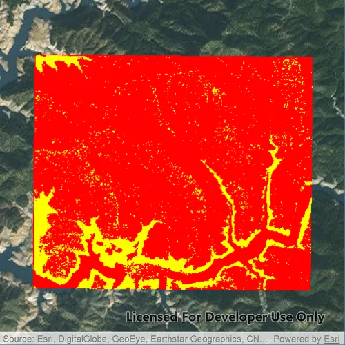
A colormap renderer transforms pixel values in a raster to display raster data based on specific colors, aiding in visual analysis of the data. For example, a forestry commission may want to quickly visualize areas above and below the tree-line line occurring at a know elevation on a raster containing elevation values. They could overlay a transparent colormap set to color those areas below the tree-line elevation green, and those above white.
How to use the sample
Pan and zoom to explore the effect of the colormap applied to the raster.
How it works
- Create a
Rasterfrom a raster file. - Create a
RasterLayerfrom the raster. - Create a
QList<QColor>: colors at the beginning of the list replace the darkest values in the raster and colors at the end of the list replaced the brightest values of the raster. - Create a colormap renderer with the color list and apply it to the raster layer with
RasterLayer::setRenderer(RasterRenderer *renderer).
Relevant API
- ColormapRenderer
- Raster
- RasterLayer
Offline Data
Read more about how to set up the sample’s offline data here.
| Link | Local Location |
|---|---|
| ShastaBW.tif raster | <userhome>/ArcGIS/Runtime/Data/raster/ShastaBW.tif |
About the data
The raster used in this sample shows an area in the south of the Shasta-Trinity National Forest, California.
Tags
colormap, data, raster, renderer, visualization
Sample code
// [WriteFile Name=RasterColormapRenderer, Category=Layers]// [Legal]// Copyright 2017 Esri.//// Licensed under the Apache License, Version 2.0 (the "License");// you may not use this file except in compliance with the License.// You may obtain a copy of the License at// http://www.apache.org/licenses/LICENSE-2.0//// Unless required by applicable law or agreed to in writing, software// distributed under the License is distributed on an "AS IS" BASIS,// WITHOUT WARRANTIES OR CONDITIONS OF ANY KIND, either express or implied.// See the License for the specific language governing permissions and// limitations under the License.// [Legal]
#ifdef PCH_BUILD#include "pch.hpp"#endif // PCH_BUILD
// sample headers#include "RasterColormapRenderer.h"
// ArcGIS Maps SDK headers#include "ColormapRenderer.h"#include "Envelope.h"#include "Error.h"#include "LayerListModel.h"#include "Map.h"#include "MapQuickView.h"#include "MapTypes.h"#include "MapViewTypes.h"#include "Raster.h"#include "RasterLayer.h"
// Qt headers#include <QFuture>#include <QStandardPaths>#include <QtCore/qglobal.h>
using namespace Esri::ArcGISRuntime;
// helper method to get cross platform data pathnamespace{  QString defaultDataPath()  {    QString dataPath;
#ifdef Q_OS_IOS    dataPath = QStandardPaths::writableLocation(QStandardPaths::DocumentsLocation);#else    dataPath = QStandardPaths::writableLocation(QStandardPaths::HomeLocation);#endif
    return dataPath;  }} // namespace
RasterColormapRenderer::RasterColormapRenderer(QQuickItem* parent /* = nullptr */) :  QQuickItem(parent),  m_dataPath(defaultDataPath() + "/ArcGIS/Runtime/Data/raster"){}
RasterColormapRenderer::~RasterColormapRenderer() = default;
void RasterColormapRenderer::init(){  // Register the map view for QML  qmlRegisterType<MapQuickView>("Esri.Samples", 1, 0, "MapView");  qmlRegisterType<RasterColormapRenderer>("Esri.Samples", 1, 0, "RasterColormapRendererSample");}
void RasterColormapRenderer::componentComplete(){  QQuickItem::componentComplete();
  // find QML MapView component  m_mapView = findChild<MapQuickView*>("mapView");  m_mapView->setWrapAroundMode(WrapAroundMode::Disabled);
  //! [RasterColormapRenderer cpp add raster basemap]  // Create the raster and raster layer  Raster* raster = new Raster(m_dataPath + "/ShastaBW.tif", this);  m_rasterLayer = new RasterLayer(raster, this);
  connect(m_rasterLayer, &RasterLayer::doneLoading, this, [this](const Error& error)  {    if (!error.isEmpty())    {      qDebug() << error.message() << error.additionalMessage();      return;    }
    m_mapView->setViewpointGeometryAsync(m_rasterLayer->fullExtent(), 50);  });
  ColormapRenderer* colormapRenderer = createRenderer();
  // set the colormap renderer on the raster layer  m_rasterLayer->setRenderer(colormapRenderer);
  // Add the raster to the map as an operational layer  Map* map = new Map(BasemapStyle::ArcGISImageryStandard, this);
  map->operationalLayers()->append(m_rasterLayer);
  m_mapView->setMap(map);  //! [RasterColormapRenderer cpp add raster basemap]}
ColormapRenderer* RasterColormapRenderer::createRenderer(){  // create a color map where values 0-150 are red and 150-250 are yellow  QList<QColor> colors;  colors.reserve(250);  for (int i = 0; i < 250; ++i)  {    colors.append(i < 150 ? Qt::red : Qt::yellow);  }
  // create a colormap renderer  ColormapRenderer* colormapRenderer = new ColormapRenderer(colors, this);
  return colormapRenderer;}
// [WriteFile Name=RasterColormapRenderer, Category=Layers]// [Legal]// Copyright 2017 Esri.//// Licensed under the Apache License, Version 2.0 (the "License");// you may not use this file except in compliance with the License.// You may obtain a copy of the License at// http://www.apache.org/licenses/LICENSE-2.0//// Unless required by applicable law or agreed to in writing, software// distributed under the License is distributed on an "AS IS" BASIS,// WITHOUT WARRANTIES OR CONDITIONS OF ANY KIND, either express or implied.// See the License for the specific language governing permissions and// limitations under the License.// [Legal]
#ifndef COLORMAPRENDERER_H#define COLORMAPRENDERER_H
// Qt headers#include <QQuickItem>
namespace Esri::ArcGISRuntime{ class ColormapRenderer; class Map; class MapQuickView; class RasterLayer;} // namespace Esri::ArcGISRuntime
class RasterColormapRenderer : public QQuickItem{ Q_OBJECT
public: explicit RasterColormapRenderer(QQuickItem* parent = nullptr); ~RasterColormapRenderer() override;
static void init();
void componentComplete() override;
private: Esri::ArcGISRuntime::ColormapRenderer* createRenderer();
Esri::ArcGISRuntime::Map* m_map = nullptr; Esri::ArcGISRuntime::MapQuickView* m_mapView = nullptr; Esri::ArcGISRuntime::RasterLayer* m_rasterLayer = nullptr; QString m_dataPath;};
#endif // COLORMAPRENDERER_H// [WriteFile Name=RasterColormapRenderer, Category=Layers]// [Legal]// Copyright 2017 Esri.//// Licensed under the Apache License, Version 2.0 (the "License");// you may not use this file except in compliance with the License.// You may obtain a copy of the License at// http://www.apache.org/licenses/LICENSE-2.0//// Unless required by applicable law or agreed to in writing, software// distributed under the License is distributed on an "AS IS" BASIS,// WITHOUT WARRANTIES OR CONDITIONS OF ANY KIND, either express or implied.// See the License for the specific language governing permissions and// limitations under the License.// [Legal]
import QtQuickimport QtQuick.Controlsimport Esri.Samples
RasterColormapRendererSample { id: rootRectangle clip: true width: 800 height: 800
// add a mapView component MapView { anchors.fill: parent objectName: "mapView"
Component.onCompleted: { // Set the focus on MapView to initially enable keyboard navigation forceActiveFocus(); } }}