Create and use a raster layer made from a local raster file.
Use case
Rasters can be digital aerial photographs, imagery from satellites, digital pictures, or even scanned maps. An end-user will frequently need to import raster files acquired through various data-collection methods into their map to view and analyze the data.
How to use the sample
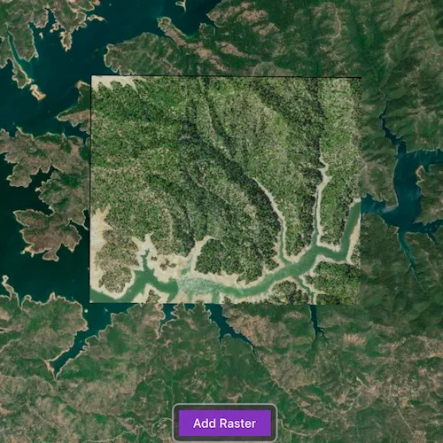
The sample will load with a map showing a basemap and a loaded raster layer. Tap on “Add Raster” to browse for a new raster file. On desktop platforms the sample also allows you to drag and drop supported raster files to load.
How it works
- Create a
Rasterfrom a raster file. - Create a
RasterLayerfrom the raster. - Add it as an operational layer with
map::operationalLayers()::append(rasterLayer).
Relevant API
- Raster
- RasterLayer
Offline Data
Read more about how to set up the sample’s offline data here.
| Link | Local Location |
|---|---|
| Shasta.tif raster | <userhome>/ArcGIS/Runtime/Data/raster/Shasta.tif |
Additional information
See the topic What is raster data? in the ArcMap documentation for more information about raster images.
Tags
data, image, import, layer, raster, visualization
Sample code
// [WriteFile Name=RasterLayerFile, Category=Analysis]// [Legal]// Copyright 2016 Esri.//// Licensed under the Apache License, Version 2.0 (the "License");// you may not use this file except in compliance with the License.// You may obtain a copy of the License at// http://www.apache.org/licenses/LICENSE-2.0//// Unless required by applicable law or agreed to in writing, software// distributed under the License is distributed on an "AS IS" BASIS,// WITHOUT WARRANTIES OR CONDITIONS OF ANY KIND, either express or implied.// See the License for the specific language governing permissions and// limitations under the License.// [Legal]
#ifdef PCH_BUILD#include "pch.hpp"#endif // PCH_BUILD
// sample headers#include "RasterLayerFile.h"
// ArcGIS Maps SDK headers#include "Basemap.h"#include "Envelope.h"#include "Error.h"#include "LayerListModel.h"#include "Map.h"#include "MapQuickView.h"#include "MapTypes.h"#include "MapViewTypes.h"#include "Point.h"#include "Raster.h"#include "RasterLayer.h"
// Qt headers#include <QFuture>#include <QStandardPaths>#include <QUrl>#include <QtCore/qglobal.h>
using namespace Esri::ArcGISRuntime;
// helper method to get cross platform data pathnamespace{  QString defaultDataPath()  {    QString dataPath;
#ifdef Q_OS_IOS    dataPath = QStandardPaths::writableLocation(QStandardPaths::DocumentsLocation);#else    dataPath = QStandardPaths::writableLocation(QStandardPaths::HomeLocation);#endif
    return dataPath;  }} // namespace
RasterLayerFile::RasterLayerFile(QQuickItem* parent /* = nullptr */) :  QQuickItem(parent){}
RasterLayerFile::~RasterLayerFile() = default;
void RasterLayerFile::init(){  qmlRegisterType<MapQuickView>("Esri.Samples", 1, 0, "MapView");  qmlRegisterType<RasterLayerFile>("Esri.Samples", 1, 0, "RasterLayerFileSample");}
void RasterLayerFile::componentComplete(){  QQuickItem::componentComplete();
  const QString dataPath = defaultDataPath() + "/ArcGIS/Runtime/Data/raster/";
  // find QML MapView component  m_mapView = findChild<MapQuickView*>("mapView");  m_mapView->setWrapAroundMode(WrapAroundMode::Disabled);
  Basemap* basemap = new Basemap(BasemapStyle::ArcGISImageryStandard, this);  m_map = new Map(basemap, this);  m_mapView->setMap(m_map);
  // Create a map using a raster layer  createAndAddRasterLayer(dataPath + "Shasta.tif");}
void RasterLayerFile::createAndAddRasterLayer(QString dataPath){  // correct data path if contains file:/ prefix  if (dataPath.contains("file:/"))  {    dataPath = QString(QUrl(dataPath).toLocalFile());  }
  //! [RasterLayerFile cpp new raster layer]  Raster* raster = new Raster(dataPath, this);  RasterLayer* rasterLayer = new RasterLayer(raster, this);  //! [RasterLayerFile cpp new raster layer]
  connect(rasterLayer, &RasterLayer::doneLoading, this, [this, rasterLayer](const Error& loadError)  {    if (!loadError.isEmpty())    {      return;    }
    m_mapView->setViewpointCenterAsync(rasterLayer->fullExtent().center(), 80000);  });
  m_map->operationalLayers()->clear();  m_map->operationalLayers()->append(rasterLayer);}
// [WriteFile Name=RasterLayerFile, Category=Analysis]// [Legal]// Copyright 2016 Esri.//// Licensed under the Apache License, Version 2.0 (the "License");// you may not use this file except in compliance with the License.// You may obtain a copy of the License at// http://www.apache.org/licenses/LICENSE-2.0//// Unless required by applicable law or agreed to in writing, software// distributed under the License is distributed on an "AS IS" BASIS,// WITHOUT WARRANTIES OR CONDITIONS OF ANY KIND, either express or implied.// See the License for the specific language governing permissions and// limitations under the License.// [Legal]
#ifndef RASTERLAYERFILE_H#define RASTERLAYERFILE_H
// Qt headers#include <QQuickItem>
namespace Esri::ArcGISRuntime{ class Map; class MapQuickView;} // namespace Esri::ArcGISRuntime
class RasterLayerFile : public QQuickItem{ Q_OBJECT
public: explicit RasterLayerFile(QQuickItem* parent = nullptr); ~RasterLayerFile() override;
void componentComplete() override; static void init();
Q_INVOKABLE void createAndAddRasterLayer(QString dataPath);
private: Esri::ArcGISRuntime::Map* m_map = nullptr; Esri::ArcGISRuntime::MapQuickView* m_mapView = nullptr;};
#endif // RASTERLAYERFILE_H// [WriteFile Name=RasterLayerFile, Category=Layers]// [Legal]// Copyright 2016 Esri.//// Licensed under the Apache License, Version 2.0 (the "License");// you may not use this file except in compliance with the License.// You may obtain a copy of the License at// http://www.apache.org/licenses/LICENSE-2.0//// Unless required by applicable law or agreed to in writing, software// distributed under the License is distributed on an "AS IS" BASIS,// WITHOUT WARRANTIES OR CONDITIONS OF ANY KIND, either express or implied.// See the License for the specific language governing permissions and// limitations under the License.// [Legal]
import QtQuickimport Qt.labs.platform
Item { id: root signal rasterFileChosen(url url);
property var supportedExtensions: [] property alias folder: fileDialog.folder
function open() { fileDialog.open(); }
DropArea { anchors.fill: parent
onDropped: { if (!drop.hasText) return;
if (drop.urls.length !== 1) return;
if (!root.validateFileExtension(drop.urls[0])) return;
if (drop.proposedAction !== Qt.MoveAction && drop.proposedAction !== Qt.CopyAction) return;
drop.acceptProposedAction(); root.rasterFileChosen(drop.urls[0]); } }
FileDialog { id: fileDialog
onAccepted: { root.rasterFileChosen(fileDialog.file) } }
function validateFileExtension(filePath) { const extension = filePath.split('.').pop(); const idx = supportedExtensions.indexOf(extension);
return idx !== -1; }
onSupportedExtensionsChanged: { let nameFiltersString = "Raster files ("; for (let i = 0; i < supportedFormats.length; i++) nameFiltersString += "*." + supportedFormats[i] + " ";
nameFiltersString += ")"; fileDialog.nameFilters = nameFiltersString; }}// [WriteFile Name=RasterLayerFile, Category=Analysis]// [Legal]// Copyright 2016 Esri.//// Licensed under the Apache License, Version 2.0 (the "License");// you may not use this file except in compliance with the License.// You may obtain a copy of the License at// http://www.apache.org/licenses/LICENSE-2.0//// Unless required by applicable law or agreed to in writing, software// distributed under the License is distributed on an "AS IS" BASIS,// WITHOUT WARRANTIES OR CONDITIONS OF ANY KIND, either express or implied.// See the License for the specific language governing permissions and// limitations under the License.// [Legal]
import QtQuickimport QtQuick.Controlsimport Esri.Samples
RasterLayerFileSample { id: rootRectangle clip: true
readonly property var supportedFormats: ["img","I12","dt0","dt1","dt2","tc2","geotiff","tif", "tiff", "hr1","jpg","jpeg","jp2","ntf","png","i21","ovr"]
// add a mapView component MapView { anchors.fill: parent objectName: "mapView"
Component.onCompleted: { // Set the focus on MapView to initially enable keyboard navigation forceActiveFocus(); } }
Rectangle { visible: addButton.visible anchors.centerIn: addButton radius: 8 height: addButton.height + (16) width: addButton.width + (16) color: palette.base border.color: "darkgrey" border.width: 2 opacity: 0.75 }
Button { id: addButton anchors { bottom: parent.bottom horizontalCenter: parent.horizontalCenter margins: 32 }
text: qsTr("Add Raster") onClicked: loader.open(); }
RasterLoader { id: loader anchors.fill: rootRectangle supportedExtensions: supportedFormats
onRasterFileChosen: url => createAndAddRasterLayer(url); }}