Find the closest vertex and coordinate of a geometry to a point.
Use case
Determine the shortest distance between a location and the boundary of an area. For example, developers can snap imprecise user clicks to a geometry if the click is within a certain distance of the geometry.
How to use the sample
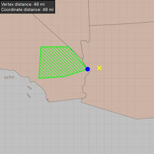
Click anywhere on the map. A yellow cross will show at that location. A blue circle will show the polygon’s nearest vertex to the point that was clicked. A red diamond will appear at the coordinate on the geometry that is nearest to the point that was clicked. If clicked inside the geometry, the red and orange markers will overlap. The information box showing distance between the clicked point and the nearest vertex/coordinate will be updated with every new location clicked.
How it works
- Get a
Geometryand aPointto check the nearest vertex against. - Call
GeometryEngine::nearestVertex(inputGeometry, point). - Use the returned
ProximityResultto get thePointrepresenting the polygon vertex, and to determine the distance between that vertex and the clicked point. - Call
GeometryEngine::nearestCoordinate(inputGeometry, point). - Use the returned
ProximityResultto get thePointrepresenting the coordinate on the polygon, and to determine the distance between that coordinate and the clicked point.
Relevant API
- GeometryEngine
- ProximityResult
Additional information
The value of ProximityResult::distance() is planar (Euclidean) distance. Planar distances are only accurate for geometries that have a defined projected coordinate system, which maintain the desired level of accuracy. The example polygon in this sample is defined in California State Plane Coordinate System - Zone 5 (WKID 2229), which maintains accuracy near Southern California. Accuracy declines outside the state plane zone.
Tags
analysis, coordinate, geometry, nearest, proximity, vertex
Sample code
// [WriteFile Name=NearestVertex, Category=Geometry]// [Legal]// Copyright 2020 Esri.//// Licensed under the Apache License, Version 2.0 (the "License");// you may not use this file except in compliance with the License.// You may obtain a copy of the License at// http://www.apache.org/licenses/LICENSE-2.0//// Unless required by applicable law or agreed to in writing, software// distributed under the License is distributed on an "AS IS" BASIS,// WITHOUT WARRANTIES OR CONDITIONS OF ANY KIND, either express or implied.// See the License for the specific language governing permissions and// limitations under the License.// [Legal]
#ifdef PCH_BUILD#include "pch.hpp"#endif // PCH_BUILD
// sample headers#include "NearestVertex.h"
// ArcGIS Maps SDK headers#include "Basemap.h"#include "Envelope.h"#include "FeatureLayer.h"#include "GeometryEngine.h"#include "Graphic.h"#include "GraphicListModel.h"#include "GraphicsOverlay.h"#include "GraphicsOverlayListModel.h"#include "LayerListModel.h"#include "Map.h"#include "MapQuickView.h"#include "Point.h"#include "PolygonBuilder.h"#include "PortalItem.h"#include "ProximityResult.h"#include "SimpleFillSymbol.h"#include "SimpleLineSymbol.h"#include "SimpleMarkerSymbol.h"#include "SpatialReference.h"#include "SymbolTypes.h"
// Qt headers#include <QFuture>
using namespace Esri::ArcGISRuntime;
namespace{  const SpatialReference statePlaneCaliforniaZone5SpatialReference = SpatialReference(2229);}
NearestVertex::NearestVertex(QObject* parent /* = nullptr */) :  QObject(parent){  m_map = new Map(statePlaneCaliforniaZone5SpatialReference, this);
  PortalItem* portalItem = new PortalItem("8c2d6d7df8fa4142b0a1211c8dd66903", this);  FeatureLayer* usStatesGeneralizedLayer = new FeatureLayer(portalItem, this);  m_map->basemap()->baseLayers()->append(usStatesGeneralizedLayer);}
NearestVertex::~NearestVertex() = default;
void NearestVertex::init(){  // Register the map view for QML  qmlRegisterType<MapQuickView>("Esri.Samples", 1, 0, "MapView");  qmlRegisterType<NearestVertex>("Esri.Samples", 1, 0, "NearestVertexSample");}
MapQuickView* NearestVertex::mapView() const{  return m_mapView;}
int NearestVertex::vertexDistance() const{  return m_vertexDistance;}
int NearestVertex::coordinateDistance() const{  return m_coordinateDistance;}
// Set the view (created in QML)void NearestVertex::setMapView(MapQuickView* mapView){  if (!mapView || mapView == m_mapView)  {    return;  }
  m_mapView = mapView;  m_mapView->setMap(m_map);
  // shows the polygon, clicked location, and nearest coordinate and vertex on polygon  setupGraphics();
  // Set viewpoint to the polygon graphic  m_mapView->setViewpointCenterAsync(m_mapView->graphicsOverlays()->first()->graphics()->first()->geometry().extent().center(), 8e6);
  emit mapViewChanged();}
void NearestVertex::setupGraphics(){  // create a graphics overlay to show the polygon, clicked location, and nearest vertex  GraphicsOverlay* graphicsOverlay = new GraphicsOverlay(this);
  // Construct a polygon from a point collection that uses the California zone 5 (ftUS) state plane coordinate system  QList<Point> points = {Point(6627416.41469281, 1804532.53233782), Point(6669147.89779046, 2479145.16609522),                         Point(7265673.02678292, 2484254.50442408), Point(7676192.55880379, 2001458.66365744),                         Point(7175695.94143837, 1840722.34474458)};
  PolygonBuilder* polygonBuilder = new PolygonBuilder(statePlaneCaliforniaZone5SpatialReference, this);  polygonBuilder->addPoints(points);  SimpleLineSymbol* polygonOutlineSymbol = new SimpleLineSymbol(SimpleLineSymbolStyle::Solid, Qt::green, 2, this);  SimpleFillSymbol* polygonFillSymbol = new SimpleFillSymbol(SimpleFillSymbolStyle::ForwardDiagonal, Qt::green, polygonOutlineSymbol, this);  Graphic* polygonGraphic = new Graphic(polygonBuilder->toGeometry(), polygonFillSymbol, this);
  graphicsOverlay->graphics()->append(polygonGraphic);
  // create graphics for the clicked location, nearest coordinate, and nearest vertex markers  SimpleMarkerSymbol* clickedLocationSymbol = new SimpleMarkerSymbol(SimpleMarkerSymbolStyle::X, Qt::yellow, 15, this);  SimpleMarkerSymbol* nearestCoordinateSymbol = new SimpleMarkerSymbol(SimpleMarkerSymbolStyle::Diamond, Qt::red, 10, this);  SimpleMarkerSymbol* nearestVertexSymbol = new SimpleMarkerSymbol(SimpleMarkerSymbolStyle::Circle, Qt::blue, 15, this);
  Graphic* clickedLocationGraphic = new Graphic(this);  clickedLocationGraphic->setSymbol(clickedLocationSymbol);  Graphic* nearestCoordinateGraphic = new Graphic(this);  nearestCoordinateGraphic->setSymbol(nearestCoordinateSymbol);  Graphic* nearestVertexGraphic = new Graphic(this);  nearestVertexGraphic->setSymbol(nearestVertexSymbol);
  graphicsOverlay->graphics()->append(clickedLocationGraphic);  graphicsOverlay->graphics()->append(nearestCoordinateGraphic);  graphicsOverlay->graphics()->append(nearestVertexGraphic);
  // add graphic to clicked location  connect(m_mapView, &MapQuickView::mouseClicked, this,          [nearestVertexGraphic, nearestCoordinateGraphic, polygonBuilder, clickedLocationGraphic, this](QMouseEvent& e)  {    const Point clickedLocation = m_mapView->screenToLocation(e.position().x(), e.position().y());    // normalizing the geometry before performing geometric operations    const Point normalizedPoint = geometry_cast<Point>(GeometryEngine::normalizeCentralMeridian(clickedLocation));
    clickedLocationGraphic->setGeometry(normalizedPoint);
    const ProximityResult nearestCoordinateResult = GeometryEngine::nearestCoordinate(polygonBuilder->toGeometry(), normalizedPoint);    nearestCoordinateGraphic->setGeometry(nearestCoordinateResult.coordinate());
    const ProximityResult nearestVertexResult = GeometryEngine::nearestVertex(polygonBuilder->toGeometry(), normalizedPoint);    nearestVertexGraphic->setGeometry(nearestVertexResult.coordinate());
    // get the distances to the nearest vertex and nearest coordinate, converted from feet to miles    m_vertexDistance = nearestVertexResult.distance() / 5280;    m_coordinateDistance = nearestCoordinateResult.distance() / 5280;
    e.accept();    emit vertexDistanceCalculated();    emit coordinateDistanceCalculated();  });
  m_mapView->graphicsOverlays()->append(graphicsOverlay);}
// [WriteFile Name=NearestVertex, Category=Geometry]// [Legal]// Copyright 2020 Esri.//// Licensed under the Apache License, Version 2.0 (the "License");// you may not use this file except in compliance with the License.// You may obtain a copy of the License at// http://www.apache.org/licenses/LICENSE-2.0//// Unless required by applicable law or agreed to in writing, software// distributed under the License is distributed on an "AS IS" BASIS,// WITHOUT WARRANTIES OR CONDITIONS OF ANY KIND, either express or implied.// See the License for the specific language governing permissions and// limitations under the License.// [Legal]
#ifndef NEARESTVERTEX_H#define NEARESTVERTEX_H
// Qt headers#include <QObject>
namespace Esri::ArcGISRuntime{ class Map; class MapQuickView;} // namespace Esri::ArcGISRuntime
Q_MOC_INCLUDE("MapQuickView.h")
class NearestVertex : public QObject{ Q_OBJECT
Q_PROPERTY(Esri::ArcGISRuntime::MapQuickView* mapView READ mapView WRITE setMapView NOTIFY mapViewChanged) Q_PROPERTY(int vertexDistance READ vertexDistance NOTIFY vertexDistanceCalculated) Q_PROPERTY(int coordinateDistance READ coordinateDistance NOTIFY coordinateDistanceCalculated)
public: explicit NearestVertex(QObject* parent = nullptr); ~NearestVertex();
static void init();
signals: void mapViewChanged(); void vertexDistanceCalculated(); void coordinateDistanceCalculated();
private: Esri::ArcGISRuntime::MapQuickView* mapView() const; int vertexDistance() const; int coordinateDistance() const; void setMapView(Esri::ArcGISRuntime::MapQuickView* mapView); void setupGraphics();
Esri::ArcGISRuntime::Map* m_map = nullptr; Esri::ArcGISRuntime::MapQuickView* m_mapView = nullptr; int m_vertexDistance = 0; int m_coordinateDistance = 0;};
#endif // NEARESTVERTEX_H// [WriteFile Name=NearestVertex, Category=Geometry]// [Legal]// Copyright 2020 Esri.//// Licensed under the Apache License, Version 2.0 (the "License");// you may not use this file except in compliance with the License.// You may obtain a copy of the License at// http://www.apache.org/licenses/LICENSE-2.0//// Unless required by applicable law or agreed to in writing, software// distributed under the License is distributed on an "AS IS" BASIS,// WITHOUT WARRANTIES OR CONDITIONS OF ANY KIND, either express or implied.// See the License for the specific language governing permissions and// limitations under the License.// [Legal]
import QtQuickimport QtQuick.Controlsimport Esri.Samples
Item {
// add a mapView component MapView { id: view anchors.fill: parent
Component.onCompleted: { // Set the focus on MapView to initially enable keyboard navigation forceActiveFocus(); } }
// Declare the C++ instance which creates the map etc. and supply the view NearestVertexSample { id: model mapView: view }
// Rectangle to display distances Rectangle { width: childrenRect.width height: childrenRect.height color: palette.base border.color: "black" border.width: 2
MouseArea { anchors.fill: parent acceptedButtons: Qt.LeftButton | Qt.RightButton onClicked: mouse => mouse.accepted = true onDoubleClicked: mouse => mouse.accepted = true onWheel: wheel => wheel.accepted = true }
Label { id: distancesLabel text: "Vertex distance: " + model.vertexDistance + " mi\nCoordinate distance: " + model.coordinateDistance + " mi"; font.pointSize: 14 padding: 5 } }}