Perform a line of sight analysis between two points in real time.
Use case
A line of sight analysis can be used to assess whether a view is obstructed between an observer and a target. Obstructing features could either be natural, like topography, or man-made, like buildings. Consider an events planning company wanting to commemorate a national event by lighting sequential beacons across hill summits or roof tops. To guarantee a successful event, ensuring an unobstructed line of sight between neighboring beacons would allow each beacon to be activated as intended.
How to use the sample
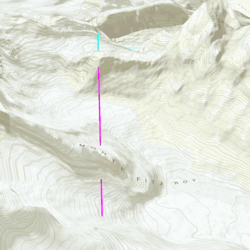
The sample loads with a preset observer and target location, linked by a colored line. A red segment on the line means the view between observer and target is obstructed, whereas green means the view is unobstructed.
Click and hold to turn on the mouse moved signal, then move the mouse to update the target location in real time. Release the click to lock the target location.
How it works
- Create an
AnalysisOverlayand add it to the scene view. - Create a
LocationLineOfSightwith initial observer and target locations and add it to the analysis overlay. - Connect to the
SceneQuickView::mouseClickedslot to capture to capture mouse movement. Turn the screen point into a scene point withsceneView::screenToLocation(screenPoint). - Update the target location with
LineOfSight::setTargetLocation(scenePoint).
Relevant API
- AnalysisOverlay
- LocationLineOfSight
- SceneView
Tags
3D, line of sight, visibility, visibility analysis
Sample Code
// [WriteFile Name=LineOfSightLocation, Category=Analysis]
// [Legal]
// Copyright 2017 Esri.
// Licensed under the Apache License, Version 2.0 (the "License");
// you may not use this file except in compliance with the License.
// You may obtain a copy of the License at
// http://www.apache.org/licenses/LICENSE-2.0
// Unless required by applicable law or agreed to in writing, software
// distributed under the License is distributed on an "AS IS" BASIS,
// WITHOUT WARRANTIES OR CONDITIONS OF ANY KIND, either express or implied.
// See the License for the specific language governing permissions and
// limitations under the License.
// [Legal]
#ifdef PCH_BUILD
#include "pch.hpp"
#endif // PCH_BUILD
#include "LineOfSightLocation.h"
#include "ArcGISTiledElevationSource.h"
#include "Scene.h"
#include "SceneQuickView.h"
#include "LocationLineOfSight.h"
#include "AnalysisOverlay.h"
#include "Camera.h"
#include "MapTypes.h"
#include "Surface.h"
#include "ElevationSourceListModel.h"
#include "AnalysisOverlayListModel.h"
#include "AnalysisListModel.h"
#include "SpatialReference.h"
#include "Point.h"
#include <QFuture>
using namespace Esri::ArcGISRuntime;
LineOfSightLocation::LineOfSightLocation(QQuickItem* parent /* = nullptr */):
QQuickItem(parent)
{
}
void LineOfSightLocation::init()
{
// Register classes for QML
qmlRegisterType<SceneQuickView>("Esri.Samples", 1, 0, "SceneView");
qmlRegisterType<LineOfSightLocation>("Esri.Samples", 1, 0, "LineOfSightLocationSample");
}
void LineOfSightLocation::componentComplete()
{
QQuickItem::componentComplete();
// Create a scene and give it to the SceneView
m_sceneView = findChild<SceneQuickView*>("sceneView");
Scene* scene = new Scene(BasemapStyle::ArcGISTopographic, this);
Surface* surface = new Surface(this);
surface->elevationSources()->append(
new ArcGISTiledElevationSource(
QUrl("https://elevation3d.arcgis.com/arcgis/rest/services/WorldElevation3D/Terrain3D/ImageServer"),
this));
scene->setBaseSurface(surface);
m_sceneView->setArcGISScene(scene);
// Add an Analysis Overlay
m_analysisOverlay = new AnalysisOverlay(this);
m_sceneView->analysisOverlays()->append(m_analysisOverlay);
// set initial viewpoint
setInitialViewpoint();
// create LocationLineOfSight
createLineOfSight();
// connect signals
connectSignals();
}
void LineOfSightLocation::createLineOfSight()
{
// create the observer/target points
const Point observerPt(-73.06958032962375, -49.253112971555446, 2000, SpatialReference::wgs84());
const Point targetPt(-73.079266999709162, -49.300457676730559, 1312, SpatialReference::wgs84());
// create the line of sight
m_lineOfSight = new LocationLineOfSight(observerPt, targetPt, this);
m_analysisOverlay->analyses()->append(m_lineOfSight);
// configure the LoS color and width
LineOfSight::setVisibleColor(QColor("cyan"));
LineOfSight::setObstructedColor(QColor("magenta"));
LineOfSight::setLineWidth(2.0f);
}
void LineOfSightLocation::setInitialViewpoint()
{
// Set a viewpoint
Point point(-73.0815, -49.3272, 4059, SpatialReference::wgs84());
const double heading = 11;
const double pitch = 62;
const double roll = 0;
Camera camera(point, heading, pitch, roll);
m_sceneView->setViewpointCameraAsync(camera);
}
void LineOfSightLocation::connectSignals()
{
// on mouse click perform the location viewshed
connect(m_sceneView, &SceneQuickView::mouseClicked, this, [this](QMouseEvent& event)
{
const Point pt = m_sceneView->screenToBaseSurface(event.position().x(), event.position().y());
m_lineOfSight->setTargetLocation(pt);
});
connect(m_sceneView, &SceneQuickView::mousePressedAndHeld, this, [this]
{
m_calculating = true;
});
connect(m_sceneView, &SceneQuickView::mouseMoved, this, [this](QMouseEvent& event)
{
if (m_calculating)
{
const Point pt = m_sceneView->screenToBaseSurface(event.position().x(), event.position().y());
m_lineOfSight->setTargetLocation(pt);
}
});
connect(m_sceneView, &SceneQuickView::mouseReleased, this, [this]
{
m_calculating = false;
});
}