Create a Feature Collection Layer from a Feature Collection Table, and add it to a map.
Use case
A Feature Collection allows easily importing external data (such as CSV files), as well as creating custom schema for data that is in non-standardized format. This data can then be used to populate a Feature Collection Table, and displayed in a Feature Collection Layer using the attributes and geometries provided in the external data source. For example, an electricity supplier could use this functionality to visualize existing location data of coverage areas (polygons), power stations (points), transmission lines (polylines), and others.
How to use the sample
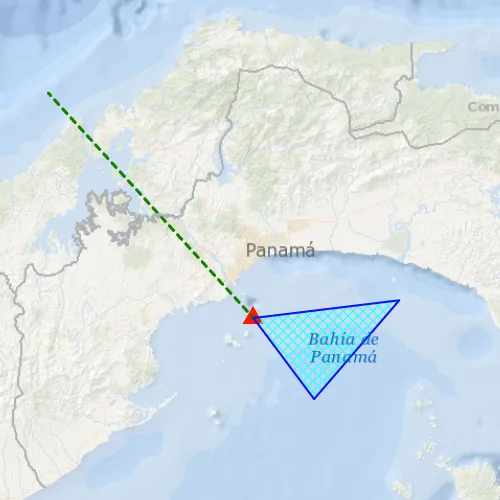
When launched, this sample displays a FeatureCollectionLayer with a Point, Polyline and Polygon geometry. Pan and zoom to explore the scene.
How it works
- Create a
FeatureCollectionLayerusing a new feature collection,FeatureCollectionLayer(featureCollection) - Add the feature collection layer to the map,
Map::operationalLayers()::append(featureCollectionLayer). - Create a
FeatureCollectionTablefor theGeometryTypesPoint,Polyline, andPolygon,FeatureCollectionTable(fields, geometryType, spatialRefernce)- Additionally, pass in a list of
Fieldobjects to represent the table’s schema. In this case a field of type String namednameis added.
- Additionally, pass in a list of
- Assign a
SimpleRendererto each table to render anyFeatures from that table using theSymbolthat was set. - Add the feature collection table to the feature collection,
FeatureCollection::tables()::append(featureCollectionTable). - Use the
createFeaturemethod to create a feature from the feature collection table, passing an attribute and geometry for that feature,FeatureCollectionTable::createFeature(attributes, geometry). - Add new features to the table,
FeatureCollectionTable::addFeatureAsync(feature).
Relevant API
- Feature
- FeatureCollection
- FeatureCollectionLayer
- FeatureCollectionTable
- Field
- SimpleRenderer
Tags
collection, feature, layers, table
Sample code
// [WriteFile Name=Feature_Collection_Layer, Category=Layers]// [Legal]// Copyright 2016 Esri.//// Licensed under the Apache License, Version 2.0 (the "License");// you may not use this file except in compliance with the License.// You may obtain a copy of the License at// http://www.apache.org/licenses/LICENSE-2.0//// Unless required by applicable law or agreed to in writing, software// distributed under the License is distributed on an "AS IS" BASIS,// WITHOUT WARRANTIES OR CONDITIONS OF ANY KIND, either express or implied.// See the License for the specific language governing permissions and// limitations under the License.// [Legal]
#ifdef PCH_BUILD#include "pch.hpp"#endif // PCH_BUILD
// sample headers#include "Feature_Collection_Layer.h"
// ArcGIS Maps SDK headers#include "AttributeListModel.h"#include "Basemap.h"#include "Envelope.h"#include "Feature.h"#include "FeatureCollection.h"#include "FeatureCollectionLayer.h"#include "FeatureCollectionTable.h"#include "FeatureCollectionTableListModel.h"#include "Field.h"#include "LayerListModel.h"#include "Map.h"#include "MapQuickView.h"#include "MapTypes.h"#include "MapViewTypes.h"#include "Point.h"#include "PolygonBuilder.h"#include "PolylineBuilder.h"#include "SimpleFillSymbol.h"#include "SimpleLineSymbol.h"#include "SimpleMarkerSymbol.h"#include "SimpleRenderer.h"#include "SpatialReference.h"#include "SymbolTypes.h"#include "Viewpoint.h"
// Qt headers#include <QFuture>
using namespace Esri::ArcGISRuntime;
Feature_Collection_Layer::Feature_Collection_Layer(QQuickItem* parent /* = nullptr */) :  QQuickItem(parent){}
Feature_Collection_Layer::~Feature_Collection_Layer() = default;
void Feature_Collection_Layer::init(){  qmlRegisterType<MapQuickView>("Esri.Samples", 1, 0, "MapView");  qmlRegisterType<Feature_Collection_Layer>("Esri.Samples", 1, 0, "Feature_Collection_LayerSample");}
void Feature_Collection_Layer::componentComplete(){  QQuickItem::componentComplete();
  // find QML MapView component  m_mapView = findChild<MapQuickView*>("mapView");  m_mapView->setWrapAroundMode(WrapAroundMode::Disabled);
  // Create a map using the topographic basemap  m_map = new Map(BasemapStyle::ArcGISOceans, this);  m_map->setInitialViewpoint(    Viewpoint(Envelope(-8917856.590171767, 903277.583136797, -8800611.655131537, 1100327.8941287803, SpatialReference(102100))));
  // Set map to map view  m_mapView->setMap(m_map);
  // Create FeatureCollection and FeatureCollectionLayer  m_featureCollection = new FeatureCollection(this);  m_featureCollectionLayer = new FeatureCollectionLayer(m_featureCollection, this);
  // Add the Layer to the Map  m_map->operationalLayers()->append(m_featureCollectionLayer);
  // Create the FeatureCollectionTables  createPointTable();  createPolylineTable();  createPolygonTable();}
void Feature_Collection_Layer::createPointTable(){  // Define the schema  QList<Field> pointFields;  Field placeField = Field::createText("Place", "Place Name", 50);  pointFields.append(placeField);
  // Create the table  FeatureCollectionTable* pointsTable = new FeatureCollectionTable(pointFields, GeometryType::Point, SpatialReference(4326), this);
  // Define the renderer  SimpleMarkerSymbol* sms = new SimpleMarkerSymbol(SimpleMarkerSymbolStyle::Triangle, QColor("red"), 18.0, this);  SimpleRenderer* renderer = new SimpleRenderer(sms, this);  pointsTable->setRenderer(renderer);
  // Add the table to the collection  m_featureCollection->tables()->append(pointsTable);
  // Add features to the table  Point pt1(-79.497238, 8.849289, SpatialReference::wgs84());  addPointToTable("Place", "Current location", pt1, pointsTable);}
void Feature_Collection_Layer::createPolylineTable(){  // Define the schema  QList<Field> lineFields;  Field boundaryField = Field::createText("Boundary", "Boundary Name", 50);  lineFields.append(boundaryField);
  // Create the table  FeatureCollectionTable* linesTable = new FeatureCollectionTable(lineFields, GeometryType::Polyline, SpatialReference(4326), this);
  // Define the renderer  SimpleLineSymbol* sls = new SimpleLineSymbol(SimpleLineSymbolStyle::Dash, QColor("green"), 3.0, this);  SimpleRenderer* renderer = new SimpleRenderer(sls, this);  linesTable->setRenderer(renderer);
  // Add the table to the collection  m_featureCollection->tables()->append(linesTable);
  // Add features to the table  Point pt1(-79.497238, 8.849289, SpatialReference::wgs84());  Point pt2(-80.035568, 9.432302, SpatialReference::wgs84());  QList<Point> points{pt1, pt2};  addPolylineToTable("Boundary", "AManAPlanACanalPanama", points, linesTable);}
void Feature_Collection_Layer::createPolygonTable(){  // Define the schema  QList<Field> polyFields;  Field areaField = Field::createText("Area", "Area Name", 50);  polyFields.append(areaField);
  // Create the table  FeatureCollectionTable* polysTable = new FeatureCollectionTable(polyFields, GeometryType::Polygon, SpatialReference(4326), this);
  // Define the renderer  SimpleLineSymbol* sls = new SimpleLineSymbol(SimpleLineSymbolStyle::Solid, QColor("blue"), 2.0, this);  SimpleFillSymbol* sfs = new SimpleFillSymbol(SimpleFillSymbolStyle::DiagonalCross, QColor("cyan"), sls, this);  SimpleRenderer* renderer = new SimpleRenderer(sfs, this);  polysTable->setRenderer(renderer);
  // Add the table to the collection  m_featureCollection->tables()->append(polysTable);
  // Add features to the table  const Point pt1(-79.497238, 8.849289, SpatialReference::wgs84());  const Point pt2(-79.337936, 8.638903, SpatialReference::wgs84());  const Point pt3(-79.11409, 8.895422, SpatialReference::wgs84());  const QList<Point> points{pt1, pt2, pt3};  addPolygonToTable("Area", "Restricted area", points, polysTable);}
void Feature_Collection_Layer::addPointToTable(QString attrName, QString attrValue, Point point, FeatureCollectionTable* table){  // Create the new feature  Feature* feature = table->createFeature(this);  feature->attributes()->replaceAttribute(attrName, attrValue);  feature->setGeometry(point);
  // Add the feature to the table  auto future = table->addFeatureAsync(feature);  Q_UNUSED(future)}
void Feature_Collection_Layer::addPolylineToTable(QString attrName, QString attrValue, QList<Point> points, FeatureCollectionTable* table){  // Create the new feature  Feature* feature = table->createFeature(this);  feature->attributes()->replaceAttribute(attrName, attrValue);  PolylineBuilder* builder = new PolylineBuilder(SpatialReference(4326), this);  for (const Point& pt : points)  {    builder->addPoint(pt);  }  feature->setGeometry(builder->toGeometry());
  // Add the feature to the table  auto future = table->addFeatureAsync(feature);  Q_UNUSED(future)}
void Feature_Collection_Layer::addPolygonToTable(QString attrName, QString attrValue, QList<Point> points, FeatureCollectionTable* table){  // Create the new feature  Feature* feature = table->createFeature(this);  feature->attributes()->replaceAttribute(attrName, attrValue);  PolygonBuilder* builder = new PolygonBuilder(SpatialReference(4326), this);  for (const Point& pt : points)  {    builder->addPoint(pt);  }  feature->setGeometry(builder->toGeometry());
  // Add the feature to the table  auto future = table->addFeatureAsync(feature);  Q_UNUSED(future)}
// [WriteFile Name=Feature_Collection_Layer, Category=Layers]// [Legal]// Copyright 2016 Esri.//// Licensed under the Apache License, Version 2.0 (the "License");// you may not use this file except in compliance with the License.// You may obtain a copy of the License at// http://www.apache.org/licenses/LICENSE-2.0//// Unless required by applicable law or agreed to in writing, software// distributed under the License is distributed on an "AS IS" BASIS,// WITHOUT WARRANTIES OR CONDITIONS OF ANY KIND, either express or implied.// See the License for the specific language governing permissions and// limitations under the License.// [Legal]
#ifndef FEATURE_COLLECTION_LAYER_H#define FEATURE_COLLECTION_LAYER_H
// ArcGIS Maps SDK headers#include "Point.h"
// Qt headers#include <QList>#include <QQuickItem>
namespace Esri::ArcGISRuntime{ class Map; class MapQuickView; class FeatureCollection; class FeatureCollectionLayer; class FeatureCollectionTable;} // namespace Esri::ArcGISRuntime
class Feature_Collection_Layer : public QQuickItem{ Q_OBJECT
public: explicit Feature_Collection_Layer(QQuickItem* parent = nullptr); ~Feature_Collection_Layer() override;
void componentComplete() override; static void init();
private: void createPointTable(); void createPolylineTable(); void createPolygonTable(); void addPointToTable(QString attrName, QString attrValue, Esri::ArcGISRuntime::Point point, Esri::ArcGISRuntime::FeatureCollectionTable* table); void addPolylineToTable(QString attrName, QString attrValue, QList<Esri::ArcGISRuntime::Point> points, Esri::ArcGISRuntime::FeatureCollectionTable* table); void addPolygonToTable(QString attrName, QString attrValue, QList<Esri::ArcGISRuntime::Point> points, Esri::ArcGISRuntime::FeatureCollectionTable* table);
private: Esri::ArcGISRuntime::Map* m_map = nullptr; Esri::ArcGISRuntime::MapQuickView* m_mapView = nullptr; Esri::ArcGISRuntime::FeatureCollection* m_featureCollection = nullptr; Esri::ArcGISRuntime::FeatureCollectionLayer* m_featureCollectionLayer = nullptr;};
#endif // FEATURE_COLLECTION_LAYER_H// [WriteFile Name=Feature_Collection_Layer, Category=Layers]// [Legal]// Copyright 2016 Esri.//// Licensed under the Apache License, Version 2.0 (the "License");// you may not use this file except in compliance with the License.// You may obtain a copy of the License at// http://www.apache.org/licenses/LICENSE-2.0//// Unless required by applicable law or agreed to in writing, software// distributed under the License is distributed on an "AS IS" BASIS,// WITHOUT WARRANTIES OR CONDITIONS OF ANY KIND, either express or implied.// See the License for the specific language governing permissions and// limitations under the License.// [Legal]
import QtQuickimport QtQuick.Controlsimport Esri.Samples
Feature_Collection_LayerSample { id: rootRectangle clip: true width: 800 height: 600
// add a mapView component MapView { anchors.fill: parent objectName: "mapView"
Component.onCompleted: { // Set the focus on MapView to initially enable keyboard navigation forceActiveFocus(); } }}