Create a feature collection layer to show a query result from a service feature table.
Use case
Consider a national wireless telecommunications company who wants to improve connectivity within areas of poor coverage. Their cell towers, cell tower radii and state boundaries data are held within service feature tables, which can be queried for states that don’t meet a certain threshold of coverage. The query result can be used to create and display a single feature collection layer for analysis of areas requiring improved coverage.
How to use the sample
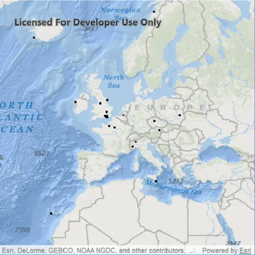
When launched, this sample displays a map with point features as a feature collection layer. Pan and zoom to explore the map.
How it works
- Perform a query using the
queryFeaturesAsync()method on aServiceFeatureTable. - Instantiate a
FeatureCollectionTablewith the result of the query. - Create a
FeatureCollectionand add the feature collection table to it. - Create a
FeatureCollectionLayerfrom the feature collection. - Add the feature collection layer to the map’s
operationalLayerslist.
Relevant API
- FeatureCollection
- FeatureCollectionLayer
- FeatureCollectionTable
- FeatureLayer
- FeatureQueryResult
- FeatureTable
- QueryParameters
- ServiceFeatureTable
About the data
This application utilizes data from the wildfire feature service. It loads at full extent with features indicating wildfire response point features across the world.
Tags
layer, query, search, table
Sample code
// [WriteFile Name=FeatureCollectionLayerQuery, Category=Layers]// [Legal]// Copyright 2017 Esri.//// Licensed under the Apache License, Version 2.0 (the "License");// you may not use this file except in compliance with the License.// You may obtain a copy of the License at// http://www.apache.org/licenses/LICENSE-2.0//// Unless required by applicable law or agreed to in writing, software// distributed under the License is distributed on an "AS IS" BASIS,// WITHOUT WARRANTIES OR CONDITIONS OF ANY KIND, either express or implied.// See the License for the specific language governing permissions and// limitations under the License.// [Legal]
#ifdef PCH_BUILD#include "pch.hpp"#endif // PCH_BUILD
// sample headers#include "FeatureCollectionLayerQuery.h"
// ArcGIS Maps SDK headers#include "FeatureCollection.h"#include "FeatureCollectionLayer.h"#include "FeatureCollectionTable.h"#include "FeatureQueryResult.h"#include "LayerListModel.h"#include "Map.h"#include "MapQuickView.h"#include "MapTypes.h"#include "QueryParameters.h"#include "ServiceFeatureTable.h"
// Qt headers#include <QFuture>#include <QString>#include <QUuid>
using namespace Esri::ArcGISRuntime;
FeatureCollectionLayerQuery::FeatureCollectionLayerQuery(QQuickItem* parent /* = nullptr */) :  QQuickItem(parent){}
void FeatureCollectionLayerQuery::init(){  // Register the map view for QML  qmlRegisterType<MapQuickView>("Esri.Samples", 1, 0, "MapView");  qmlRegisterType<FeatureCollectionLayerQuery>("Esri.Samples", 1, 0, "FeatureCollectionLayerQuerySample");}
bool FeatureCollectionLayerQuery::busy() const{  return m_busy;}
void FeatureCollectionLayerQuery::setBusy(bool val){  if (val == m_busy)  {    return;  }
  m_busy = val;  emit busyChanged();}
void FeatureCollectionLayerQuery::componentComplete(){  QQuickItem::componentComplete();
  // find QML MapView component  m_mapView = findChild<MapQuickView*>("mapView");
  // Create a map using the oceans basemap  m_map = new Map(BasemapStyle::ArcGISOceans, this);
  // Set map to map view  m_mapView->setMap(m_map);
  //initialize service feature table to be queried  m_featureTable =    new ServiceFeatureTable(QUrl(QStringLiteral("https://sampleserver6.arcgisonline.com/arcgis/rest/services/Wildfire/FeatureServer/0")), this);
  //create query parameters  QueryParameters queryParams;
  // 1=1 will give all the features from the table  queryParams.setWhereClause("1=1");
  m_featureTable->queryFeaturesAsync(queryParams)    .then(this, [this](FeatureQueryResult* featureQueryResult)  {    setBusy(false);
    if (!featureQueryResult)    {      return;    }
    //create a feature collection table fromt the query results    FeatureCollectionTable* featureCollectionTable = new FeatureCollectionTable(featureQueryResult, this);
    //create a feature collection from the above feature collection table    FeatureCollection* featureCollection = new FeatureCollection(QList<FeatureCollectionTable*>{featureCollectionTable}, this);
    //create a feature collection layer    FeatureCollectionLayer* featureCollectionLayer = new FeatureCollectionLayer(featureCollection, this);
    //add the layer to the operational layers array    m_map->operationalLayers()->append(featureCollectionLayer);  });  setBusy(true);}
// [WriteFile Name=FeatureCollectionLayerQuery, Category=Layers]// [Legal]// Copyright 2017 Esri.//// Licensed under the Apache License, Version 2.0 (the "License");// you may not use this file except in compliance with the License.// You may obtain a copy of the License at// http://www.apache.org/licenses/LICENSE-2.0//// Unless required by applicable law or agreed to in writing, software// distributed under the License is distributed on an "AS IS" BASIS,// WITHOUT WARRANTIES OR CONDITIONS OF ANY KIND, either express or implied.// See the License for the specific language governing permissions and// limitations under the License.// [Legal]
#ifndef FEATURECOLLECTIONLAYERQUERY_H#define FEATURECOLLECTIONLAYERQUERY_H
// Qt headers#include <QQuickItem>
namespace Esri::ArcGISRuntime{ class Map; class MapQuickView; class ServiceFeatureTable;} // namespace Esri::ArcGISRuntime
class FeatureCollectionLayerQuery : public QQuickItem{ Q_OBJECT
Q_PROPERTY(bool busy READ busy NOTIFY busyChanged)
public: explicit FeatureCollectionLayerQuery(QQuickItem* parent = nullptr); ~FeatureCollectionLayerQuery() override = default;
void componentComplete() override; static void init();
signals: void busyChanged();
private: bool busy() const; void setBusy(bool val);
Esri::ArcGISRuntime::Map* m_map = nullptr; Esri::ArcGISRuntime::MapQuickView* m_mapView = nullptr; Esri::ArcGISRuntime::ServiceFeatureTable* m_featureTable = nullptr; bool m_busy = false;};
#endif // FEATURECOLLECTIONLAYERQUERY_H// [WriteFile Name=FeatureCollectionLayerQuery, Category=Layers]// [Legal]// Copyright 2017 Esri.//// Licensed under the Apache License, Version 2.0 (the "License");// you may not use this file except in compliance with the License.// You may obtain a copy of the License at// http://www.apache.org/licenses/LICENSE-2.0//// Unless required by applicable law or agreed to in writing, software// distributed under the License is distributed on an "AS IS" BASIS,// WITHOUT WARRANTIES OR CONDITIONS OF ANY KIND, either express or implied.// See the License for the specific language governing permissions and// limitations under the License.// [Legal]
import QtQuickimport QtQuick.Controlsimport Esri.Samples
FeatureCollectionLayerQuerySample { id: rootRectangle clip: true width: 800 height: 600
// add a mapView component MapView { anchors.fill: parent objectName: "mapView"
Component.onCompleted: { // Set the focus on MapView to initially enable keyboard navigation forceActiveFocus(); } }
BusyIndicator { anchors.centerIn: parent visible: busy }}