Extrude features based on their attributes.
Use case
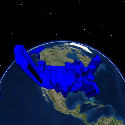
Extrusion is the process of stretching a flat, 2D shape vertically to create a 3D object in a scene. For example, you can extrude building polygons by a height value to create three-dimensional building shapes.
How to use the sample
Press the button to switch between using population density and total population for extrusion. Higher extrusion directly corresponds to higher attribute values.
How it works
- Create a
ServiceFeatureTablefrom a URL. - Create a feature layer from the service feature table.
- Make sure to set the rendering mode to dynamic,
setRenderingMode(FeatureRenderingMode::Dynamic).
- Apply a
SimpleRendererto the feature layer. - Set
ExtrusionModeof render,renderer::sceneProperties()::setExtrusionMode(ExtrusionMode::AbsoluteHeight). - Set extrusion expression of renderer,
renderer::getSceneProperties()::setExtrusionExpression("[POP2007] / 10").
Relevant API
- ExtrusionExpression
- ExtrusionMode
- FeatureLayer
- FeatureRenderingMode
- SceneProperties
- ServiceFeatureTable
- SimpleRenderer
Tags
3D, extrude, extrusion, extrusion expression, height, renderer, scene
Sample code
// [WriteFile Name=FeatureLayerExtrusion, Category=Scenes]// [Legal]// Copyright 2017 Esri.//// Licensed under the Apache License, Version 2.0 (the "License");// you may not use this file except in compliance with the License.// You may obtain a copy of the License at// http://www.apache.org/licenses/LICENSE-2.0//// Unless required by applicable law or agreed to in writing, software// distributed under the License is distributed on an "AS IS" BASIS,// WITHOUT WARRANTIES OR CONDITIONS OF ANY KIND, either express or implied.// See the License for the specific language governing permissions and// limitations under the License.// [Legal]
#ifdef PCH_BUILD#include "pch.hpp"#endif // PCH_BUILD
// sample headers#include "FeatureLayerExtrusion.h"
// ArcGIS Maps SDK headers#include "ArcGISTiledElevationSource.h"#include "Camera.h"#include "ElevationSourceListModel.h"#include "FeatureLayer.h"#include "LayerListModel.h"#include "MapTypes.h"#include "Point.h"#include "RendererSceneProperties.h"#include "Scene.h"#include "SceneQuickView.h"#include "SceneViewTypes.h"#include "ServiceFeatureTable.h"#include "SimpleFillSymbol.h"#include "SimpleLineSymbol.h"#include "SimpleRenderer.h"#include "SpatialReference.h"#include "Surface.h"#include "SymbolTypes.h"#include "Viewpoint.h"
using namespace Esri::ArcGISRuntime;
FeatureLayerExtrusion::FeatureLayerExtrusion(QQuickItem* parent /* = nullptr */) :  QQuickItem(parent),  // define line and fill symbols for a simple renderer  m_lineSymbol(new SimpleLineSymbol(SimpleLineSymbolStyle::Solid, QColor("Black"), 1.0f, this)),  m_fillSymbol(new SimpleFillSymbol(SimpleFillSymbolStyle::Solid, QColor("Blue"), m_lineSymbol, this)),  m_renderer(new SimpleRenderer(m_fillSymbol, this)){  // set renderer extrusion mode to absolute to prevent clipping  RendererSceneProperties props = m_renderer->sceneProperties();  props.setExtrusionMode(ExtrusionMode::AbsoluteHeight);  props.setExtrusionExpression("[POP2007] / 10");  m_renderer->setSceneProperties(props);}
void FeatureLayerExtrusion::init(){  // Register classes for QML  qmlRegisterType<SceneQuickView>("Esri.Samples", 1, 0, "SceneView");  qmlRegisterType<FeatureLayerExtrusion>("Esri.Samples", 1, 0, "FeatureLayerExtrusionSample");}
void FeatureLayerExtrusion::componentComplete(){  QQuickItem::componentComplete();
  // Create the feature service to use  m_featureTable = new ServiceFeatureTable(QUrl("https://sampleserver6.arcgisonline.com/arcgis/rest/services/Census/MapServer/3"), this);
  // add the service feature table to a feature layer  m_featureLayer = new FeatureLayer(m_featureTable, this);
  // set the feature layer to render dynamically to allow extrusion  m_featureLayer->setRenderingMode(FeatureRenderingMode::Dynamic);
  // set the simple renderer to the feature layer  m_featureLayer->setRenderer(m_renderer);
  // Create a scene and give it to the SceneView  m_sceneView = findChild<SceneQuickView*>("sceneView");  Scene* scene = new Scene(BasemapStyle::ArcGISImageryStandard, this);  Surface* surface = new Surface(this);  surface->elevationSources()->append(    new ArcGISTiledElevationSource(QUrl("https://elevation3d.arcgis.com/arcgis/rest/services/WorldElevation3D/Terrain3D/ImageServer"), this));  scene->setBaseSurface(surface);  scene->operationalLayers()->append(m_featureLayer);
  // set initial viewpoint  const double distance = 12940924;  const Point lookAtPoint(-99.659448, 20.513652, distance, SpatialReference::wgs84());  const Camera camera(lookAtPoint, 0, 15, 0);  const Viewpoint initialVp(lookAtPoint, distance, camera);  scene->setInitialViewpoint(initialVp);
  // apply initial extrusion  totalPopulation();
  m_sceneView->setArcGISScene(scene);}
void FeatureLayerExtrusion::popDensity(){  // multiply population density by 5000 to make data legible  RendererSceneProperties props = m_renderer->sceneProperties();  props.setExtrusionExpression("([POP07_SQMI] * 5000) + 100000");  m_renderer->setSceneProperties(props);}
void FeatureLayerExtrusion::totalPopulation(){  // divide total population by 10 to make data legible  RendererSceneProperties props = m_renderer->sceneProperties();  props.setExtrusionExpression("[POP2007] / 10");  m_renderer->setSceneProperties(props);}
// [WriteFile Name=FeatureLayerExtrusion, Category=Scenes]// [Legal]// Copyright 2017 Esri.//// Licensed under the Apache License, Version 2.0 (the "License");// you may not use this file except in compliance with the License.// You may obtain a copy of the License at// http://www.apache.org/licenses/LICENSE-2.0//// Unless required by applicable law or agreed to in writing, software// distributed under the License is distributed on an "AS IS" BASIS,// WITHOUT WARRANTIES OR CONDITIONS OF ANY KIND, either express or implied.// See the License for the specific language governing permissions and// limitations under the License.// [Legal]
#ifndef FEATURELAYEREXTRUSION_H#define FEATURELAYEREXTRUSION_H
// ArcGIS Maps SDK headers#include "Camera.h"#include "Point.h"
// Qt headers#include <QQuickItem>
namespace Esri::ArcGISRuntime{ class FeatureLayer; class ServiceFeatureTable; class SceneQuickView; class OrbitLocationCameraController; class SimpleLineSymbol; class SimpleFillSymbol; class SimpleRenderer; enum class FeatureRenderingMode;} // namespace Esri::ArcGISRuntime
class FeatureLayerExtrusion : public QQuickItem{ Q_OBJECT
public: explicit FeatureLayerExtrusion(QQuickItem* parent = nullptr); ~FeatureLayerExtrusion() override = default;
void componentComplete() override; static void init(); Q_INVOKABLE void popDensity(); Q_INVOKABLE void totalPopulation();
private: Esri::ArcGISRuntime::SceneQuickView* m_sceneView = nullptr; Esri::ArcGISRuntime::FeatureLayer* m_featureLayer = nullptr; Esri::ArcGISRuntime::ServiceFeatureTable* m_featureTable = nullptr; Esri::ArcGISRuntime::SimpleLineSymbol* m_lineSymbol = nullptr; Esri::ArcGISRuntime::SimpleFillSymbol* m_fillSymbol = nullptr; Esri::ArcGISRuntime::SimpleRenderer* m_renderer = nullptr; bool m_showTotalPopulation = true;};
#endif // FEATURELAYEREXTRUSION_H// [WriteFile Name=FeatureLayerExtrusion, Category=Scenes]// [Legal]// Copyright 2017 Esri.//// Licensed under the Apache License, Version 2.0 (the "License");// you may not use this file except in compliance with the License.// You may obtain a copy of the License at// http://www.apache.org/licenses/LICENSE-2.0//// Unless required by applicable law or agreed to in writing, software// distributed under the License is distributed on an "AS IS" BASIS,// WITHOUT WARRANTIES OR CONDITIONS OF ANY KIND, either express or implied.// See the License for the specific language governing permissions and// limitations under the License.// [Legal]
import QtQuickimport QtQuick.Controlsimport Esri.Samples
FeatureLayerExtrusionSample { id: rootRectangle clip: true width: 800 height: 600
SceneView { id: sceneView objectName: "sceneView" anchors.fill: parent
Component.onCompleted: { // Set the focus on SceneView to initially enable keyboard navigation forceActiveFocus(); }
// combo box to update the extrusion ComboBox { id: popCombo anchors { top: parent.top left: parent.left margins: 10 }
property int modelWidth: 0 width: modelWidth + leftPadding + rightPadding + (indicator ? indicator.width : 10)
model: [qsTr("TOTAL POPULATION"), qsTr("POPULATION DENSITY")]
onCurrentTextChanged: { if (currentText === "TOTAL POPULATION") totalPopulation(); else popDensity(); }
Component.onCompleted : { for (let i = 0; i < model.length; ++i) { metrics.text = model[i]; modelWidth = Math.max(modelWidth, metrics.width); } } TextMetrics { id: metrics font: popCombo.font } } }}