Show a line of sight between two moving objects.
Use case
A line of sight between GeoElements (i.e. observer and target) will not remain constant whilst one or both are on the move.
A GeoElementLineOfSight is therefore useful in cases where visibility between two GeoElements requires monitoring over a period of time in a partially obstructed field of view (such as buildings in a city).
How to use the sample
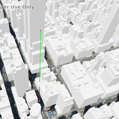
A line of sight will display between a point on the Empire State Building (observer) and a taxi (target). The taxi will drive around a block and the line of sight should automatically update. The taxi will be highlighted when it is visible. You can change the observer height with the slider to see how it affects the target's visibility.
How it works
- Instantiate an
AnalysisOverlayand add it to theSceneView's analysis overlays collection. - Instantiate a
GeoElementLineOfSight, passing in observer and targetGeoElements (features or graphics). Add the line of sight to the analysis overlay's analyses collection. - To get the target visibility when it changes, react to the target visibility changing on the
GeoElementLineOfSightinstance.
Relevant API
- AnalysisOverlay
- GeoElementLineOfSight
- LineOfSight::targetVisibility
Offline data
| Link | Local Location |
|---|---|
| Taxi CAD | <userhome>/ArcGIS/Runtime/Data/3D/dolmus\_3ds/dolmus.zip |
Tags
3D, line of sight, visibility, visibility analysis
Sample Code
// [WriteFile Name=LineOfSightGeoElement, Category=Analysis]
// [Legal]
// Copyright 2019 Esri.
// Licensed under the Apache License, Version 2.0 (the "License");
// you may not use this file except in compliance with the License.
// You may obtain a copy of the License at
// http://www.apache.org/licenses/LICENSE-2.0
// Unless required by applicable law or agreed to in writing, software
// distributed under the License is distributed on an "AS IS" BASIS,
// WITHOUT WARRANTIES OR CONDITIONS OF ANY KIND, either express or implied.
// See the License for the specific language governing permissions and
// limitations under the License.
// [Legal]
#ifdef PCH_BUILD
#include "pch.hpp"
#endif // PCH_BUILD
#include "LineOfSightGeoElement.h"
#include "ArcGISSceneLayer.h"
#include "ArcGISTiledElevationSource.h"
#include "GeoElementLineOfSight.h"
#include "GeometryEngine.h"
#include "GraphicsOverlay.h"
#include "GraphicsOverlayListModel.h"
#include "ModelSceneSymbol.h"
#include "PointBuilder.h"
#include "Scene.h"
#include "SceneQuickView.h"
#include "SceneViewTypes.h"
#include "SimpleRenderer.h"
#include "MapTypes.h"
#include "Surface.h"
#include "ElevationSourceListModel.h"
#include "LayerListModel.h"
#include "LayerSceneProperties.h"
#include "RendererSceneProperties.h"
#include "SymbolTypes.h"
#include "GraphicListModel.h"
#include "Error.h"
#include "AttributeListModel.h"
#include "AnalysisOverlay.h"
#include "AnalysisOverlayListModel.h"
#include "AnalysisListModel.h"
#include "Camera.h"
#include "GeodeticDistanceResult.h"
#include "LinearUnit.h"
#include "AngularUnit.h"
#include "SpatialReference.h"
#include "Point.h"
#include "Graphic.h"
#include "SimpleMarkerSymbol.h"
#include <array>
#include <QFuture>
#include <QtCore/qglobal.h>
#include <QStandardPaths>
using namespace Esri::ArcGISRuntime;
// helper method to get cross platform data path
namespace
{
QString defaultDataPath()
{
QString dataPath;
#ifdef Q_OS_IOS
dataPath = QStandardPaths::writableLocation(QStandardPaths::DocumentsLocation);
#else
dataPath = QStandardPaths::writableLocation(QStandardPaths::HomeLocation);
#endif
return dataPath;
}
} // namespace
namespace
{
// Initial fixed point to observe taxi.
const Point observationPoint(-73.9853, 40.7484, 200, SpatialReference::wgs84());
// Waypoints around the block for taxi to drive.
const std::array<Point, 4> waypoints = {{
{ -73.984513, 40.748469, 2, SpatialReference::wgs84() },
{ -73.985068, 40.747786, 2, SpatialReference::wgs84() },
{ -73.983452, 40.747091, 2, SpatialReference::wgs84() },
{ -73.982961, 40.747762, 2, SpatialReference::wgs84() }
}};
}
LineOfSightGeoElement::LineOfSightGeoElement(QObject* parent /* = nullptr */):
QObject(parent),
m_scene(new Scene(BasemapStyle::ArcGISImageryStandard, this))
{
// create a new elevation source from Terrain3D rest service
ArcGISTiledElevationSource* elevationSource = new ArcGISTiledElevationSource(
QUrl("https://elevation3d.arcgis.com/arcgis/rest/services/WorldElevation3D/Terrain3D/ImageServer"), this);
// add the elevation source to the scene to display elevation
m_scene->baseSurface()->elevationSources()->append(elevationSource);
// Load up the buildings that will block the line of sight.
ArcGISSceneLayer* buildings = new ArcGISSceneLayer(
QUrl("https://tiles.arcgis.com/tiles/z2tnIkrLQ2BRzr6P/arcgis/rest/services/New_York_LoD2_3D_Buildings/SceneServer/layers/0"));
m_scene->operationalLayers()->append(buildings);
// Trigger animation of taxi every 100ms.
m_animation.setInterval(100);
m_animation.callOnTimeout(this, &LineOfSightGeoElement::animate);
}
LineOfSightGeoElement::~LineOfSightGeoElement() = default;
void LineOfSightGeoElement::init()
{
// Register classes for QML
qmlRegisterType<SceneQuickView>("Esri.Samples", 1, 0, "SceneView");
qmlRegisterType<LineOfSightGeoElement>("Esri.Samples", 1, 0, "LineOfSightGeoElementSample");
}
double LineOfSightGeoElement::heightZ() const
{
if (m_observer)
{
const Point p = geometry_cast<Point>(m_observer->geometry());
return p.isValid() ? p.z() : 0.0;
}
else
{
return 0.0;
}
}
void LineOfSightGeoElement::setHeightZ(double z)
{
if (!m_observer)
return;
const Point p = geometry_cast<Point>(m_observer->geometry());
if (p.isValid())
{
PointBuilder builder(p);
builder.setZ(z);
m_observer->setGeometry(builder.toGeometry());
emit heightZChanged();
}
}
SceneQuickView* LineOfSightGeoElement::sceneView() const
{
return m_sceneView;
}
// Set the view (created in QML)
void LineOfSightGeoElement::setSceneView(SceneQuickView* sceneView)
{
if (!sceneView || sceneView == m_sceneView)
{
return;
}
m_sceneView = sceneView;
m_sceneView->setArcGISScene(m_scene);
emit sceneViewChanged();
if (!defaultDataPath().isEmpty() && m_sceneView)
initialize();
}
void LineOfSightGeoElement::initialize()
{
// Setup the graphics overlay - ensure that all z-position are relative to the height of the surface.
GraphicsOverlay* graphicsOverlay = new GraphicsOverlay(this);
{
LayerSceneProperties properties = graphicsOverlay->sceneProperties();
properties.setSurfacePlacement(SurfacePlacement::Relative);
graphicsOverlay->setSceneProperties(properties);
}
m_sceneView->graphicsOverlays()->append(graphicsOverlay);
// Set up the renderer so that we can orient the taxi using the `HEADING` attribute.
SimpleRenderer* renderer3D = new SimpleRenderer(this);
{
RendererSceneProperties properties = renderer3D->sceneProperties();
properties.setHeadingExpression("[HEADING]");
renderer3D->setSceneProperties(properties);
}
graphicsOverlay->setRenderer(renderer3D);
// Create our observation point as a red sphere.
m_observer = new Graphic(observationPoint, new SimpleMarkerSymbol(SimpleMarkerSymbolStyle::Circle, Qt::red, 5.f), this);
emit heightZChanged(); // We now have a point to extract the Z-height from.
graphicsOverlay->graphics()->append(m_observer);
// Get our Taxi model. We will attempt to load it and continue our setup after it has loaded.
const QUrl modelPath = defaultDataPath() + "/ArcGIS/Runtime/Data/3D/dolmus_3ds/dolmus.3ds";
ModelSceneSymbol* taxiSymbol = new ModelSceneSymbol(modelPath, 1.0, this);
taxiSymbol->setAnchorPosition(SceneSymbolAnchorPosition::Bottom);
connect(taxiSymbol, &ModelSceneSymbol::doneLoading, this,
[this, graphicsOverlay, taxiSymbol](const Error& error)
{
if (!error.isEmpty())
{
return;
}
// Create taxi from loaded taxi symbol, with an initial "HEADING" attribute for orientation.
m_taxi = new Graphic(waypoints.front(), taxiSymbol, this);
m_taxi->attributes()->insertAttribute("HEADING", 0.0);
graphicsOverlay->graphics()->append(m_taxi);
// Set up our line of sight analysis.
AnalysisOverlay* analysisOverlay = new AnalysisOverlay(this);
m_sceneView->analysisOverlays()->append(analysisOverlay);
GeoElementLineOfSight* lineOfSight = new GeoElementLineOfSight(m_observer, m_taxi, this);
analysisOverlay->analyses()->append(lineOfSight);
connect(lineOfSight, &GeoElementLineOfSight::targetVisibilityChanged, this,
[this](LineOfSightTargetVisibility targetVisibility)
{
// Select taxi whenever there is a clear line of sight from observer position.
m_taxi->setSelected(targetVisibility == LineOfSightTargetVisibility::Visible);
});
Camera camera(observationPoint, 700, -30, 45, 0);
m_sceneView->setViewpointCameraAsync(camera, 0);
m_animation.start();
});
taxiSymbol->load();
}
void LineOfSightGeoElement::animate()
{
// Goal point to travel to
Point waypoint = waypoints.at(m_waypointIndex);
// Calculate azimuth between current location and goal location for taxi.
Point location = geometry_cast<Point>(m_taxi->geometry());
if (!location.isValid())
return;
GeodeticDistanceResult distance = GeometryEngine::distanceGeodetic(
location, waypoint, LinearUnit::meters(), AngularUnit::degrees(), GeodeticCurveType::Geodesic);
// Move taxi one metre along the line between its current position and the goal location.
QList<Point> newPoints = GeometryEngine::moveGeodetic(
{ location }, 1.0, LinearUnit::meters(), distance.azimuth1(), AngularUnit::degrees(), GeodeticCurveType::Geodesic);
if (newPoints.size() > 0)
{
location = newPoints.last();
}
// Update taxi position and orientation.
m_taxi->setGeometry(geometry_cast<Geometry>(location));
m_taxi->attributes()->replaceAttribute("HEADING", distance.azimuth1());
// When taxi is close enough to the waypoint then increment the index for a new goal next animation step.
// Index is cyclic and an element of [0, 3].
if (distance.distance() <= 2) {
m_waypointIndex = (m_waypointIndex + 1) % waypoints.size();
}
}