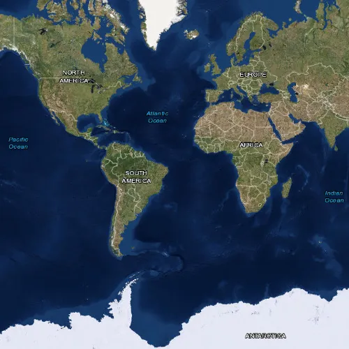
Display a map with an imagery basemap.
Use case
The map is the fundamental building block of any GIS application and is used to specify how geographic data is organized and communicated to your users.
How to use the sample
Run the sample to view the map. Pan and zoom to navigate the map.
How it works
- Create a
Mapwith a basemap using theBasemapStyle::ArcGISImageryBasemapStyle. - Create a
MapViewobject to display the map. - Set the map to the map view.
Relevant API
- BasemapStyle
- Map
- MapView
Tags
basemap, map
Sample code
// [WriteFile Name=DisplayMap, Category=Maps]// [Legal]// Copyright 2022 Esri.//// Licensed under the Apache License, Version 2.0 (the "License");// you may not use this file except in compliance with the License.// You may obtain a copy of the License at// http://www.apache.org/licenses/LICENSE-2.0//// Unless required by applicable law or agreed to in writing, software// distributed under the License is distributed on an "AS IS" BASIS,// WITHOUT WARRANTIES OR CONDITIONS OF ANY KIND, either express or implied.// See the License for the specific language governing permissions and// limitations under the License.// [Legal]
#ifdef PCH_BUILD#include "pch.hpp"#endif // PCH_BUILD
// sample headers#include "DisplayMap.h"
// ArcGIS Maps SDK headers#include "Map.h"#include "MapQuickView.h"#include "MapTypes.h"
using namespace Esri::ArcGISRuntime;
DisplayMap::DisplayMap(QObject* parent /* = nullptr */):  QObject(parent),  m_map(new Map(BasemapStyle::ArcGISImagery, this)){}
DisplayMap::~DisplayMap() = default;
void DisplayMap::init(){  // Register the map view for QML  //! [Register the map view for QML]  qmlRegisterType<MapQuickView>("Esri.Samples", 1, 0, "MapView");  //! [Register the map view for QML]  qmlRegisterType<DisplayMap>("Esri.Samples", 1, 0, "DisplayMapSample");}
MapQuickView* DisplayMap::mapView() const{  return m_mapView;}
//! [MapQuickView API Snippet]// Set the view (created in QML)void DisplayMap::setMapView(MapQuickView* mapView){  if (!mapView || mapView == m_mapView)    return;
  m_mapView = mapView;  m_mapView->setMap(m_map);
  emit mapViewChanged();} //! [MapQuickView API Snippet]
// [WriteFile Name=DisplayMap, Category=Maps]// [Legal]// Copyright 2022 Esri.//// Licensed under the Apache License, Version 2.0 (the "License");// you may not use this file except in compliance with the License.// You may obtain a copy of the License at// http://www.apache.org/licenses/LICENSE-2.0//// Unless required by applicable law or agreed to in writing, software// distributed under the License is distributed on an "AS IS" BASIS,// WITHOUT WARRANTIES OR CONDITIONS OF ANY KIND, either express or implied.// See the License for the specific language governing permissions and// limitations under the License.// [Legal]
#ifndef DISPLAYMAP_H#define DISPLAYMAP_H
// Qt headers#include <QObject>
namespace Esri::ArcGISRuntime{class Map;class MapQuickView;}
Q_MOC_INCLUDE("MapQuickView.h");
class DisplayMap : public QObject{ Q_OBJECT
Q_PROPERTY(Esri::ArcGISRuntime::MapQuickView* mapView READ mapView WRITE setMapView NOTIFY mapViewChanged)
public: explicit DisplayMap(QObject* parent = nullptr); ~DisplayMap();
static void init();
signals: void mapViewChanged();
private: Esri::ArcGISRuntime::MapQuickView* mapView() const; void setMapView(Esri::ArcGISRuntime::MapQuickView* mapView);
Esri::ArcGISRuntime::Map* m_map = nullptr; Esri::ArcGISRuntime::MapQuickView* m_mapView = nullptr;};
#endif // DISPLAYMAP_H// [WriteFile Name=DisplayMap, Category=Maps]// [Legal]// Copyright 2022 Esri.//// Licensed under the Apache License, Version 2.0 (the "License");// you may not use this file except in compliance with the License.// You may obtain a copy of the License at// http://www.apache.org/licenses/LICENSE-2.0//// Unless required by applicable law or agreed to in writing, software// distributed under the License is distributed on an "AS IS" BASIS,// WITHOUT WARRANTIES OR CONDITIONS OF ANY KIND, either express or implied.// See the License for the specific language governing permissions and// limitations under the License.// [Legal]
import QtQuickimport QtQuick.Controlsimport Esri.Samples
Item {
// add a mapView component //! [add a mapView component] MapView { id: view anchors.fill: parent
Component.onCompleted: { // Set and keep the focus on MapView to enable keyboard navigation forceActiveFocus(); } } //! [add a mapView component]
// Declare the C++ instance which creates the map etc. and supply the view DisplayMapSample { id: model mapView: view }}