Version 2.1.0 - July, 2025.
This page provides details about enhancements, deprecations, resolved issues, and known issues in the 2.1 release of ArcGIS Maps SDK for Unity.
Enhancements
This section outlines new features and improvements (what's new).
3D Tiles enhancements
This release includes several improvements to 3D Tiles support, enhancing visual fidelity, performance, and compatibility with ArcGIS content.
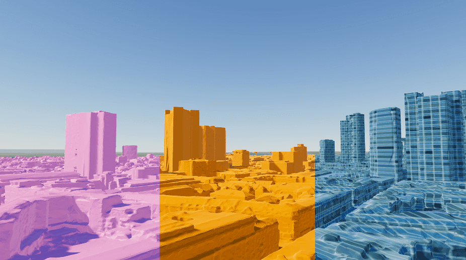
Support for lit materials
3D Tiles layers now react to lighting in the scene, resolving an issue where they appeared too dark in daytime scenes or too light in nighttime scenes.
Performance
Performance of 3D Tiles layers has been enhanced through a new data loading pattern that minimizes the amount of data fetched for a given viewpoint and prioritizes requesting data closer to the camera. Additionally, the lighting changes noted above result in reduced processing time of meshes by eliminating the need to de-index them and recalculate lighting normals. This reduction in unnecessary data loading facilitates faster load times, lower memory usage, and smoother interaction, especially when working with large 3D Tiles layers. Users can expect improved rendering performance and a more responsive overall experience.
3D Tiles with external resources
Added support for 3D Tiles services with external resources; previously, only embedded resources were supported.
Support 3D Tiles content type from ArcGIS portals
This release enhances the behavior of 3D Tiles layers when added from an ArcGIS portal. By default, 3D Tiles layers are automatically treated as containing discrete 3D objects, typically used to represent individual features such as buildings. If the portal item metadata includes the type keyword Integrated then the layer is treated as a continuous mesh, such as those from a reality capture. This change provides more accurate visual integration with the scene, especially for occlusion and relative placement purposes. For 3D Tiles services that aren't hosted as portal items, the behavior remains unchanged. For more information about type keywords, see the Items and item types page.
Scene layer performance improvements
This release brings significant performance improvements to scene layers through an optimized approach to loading Levels of Detail (LoD). This reduction in unnecessary data loading facilitates faster load times, lower memory usage, and smoother interaction, especially when working with large scene layers. Users can expect improved rendering performance and a more responsive overall experience.
Custom materials support on additional layer types
The ArcGIS Maps SDK for Unity now supports custom materials in additional layer types, including integrated mesh layers and 3D Tiles layers. This enhancement allows developers to colorize these layers using custom materials to better convey the meaning of the data and tailor their appearance to the intended audience.
Authentication persistence
This release introduces the ability to serialize OAuth credentials, allowing users to save their credentials for seamless access to protected resources across application sessions. With this feature, users can store and load existing credentials in JSON format without the need to re-authenticate each time.
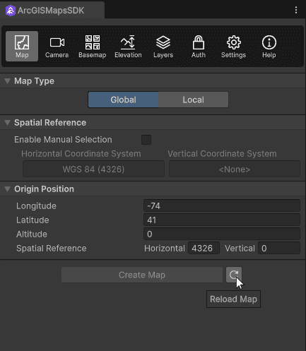
Reload map button
This release introduces a Reload Map button to improve management of spatial reference (SR) changes in scenes. When developers add or modify basemaps or elevation layers that have a different SR than the current SR of the map, the map may need to be reloaded to reflect the changes. Previously, this could only be triggered by entering Play mode or manually reloading the map, causing the map to appear out of sync. Now, the UI and components display the current SR with a one-click reload button that applies changes immediately. This enhancement simplifies map configuration and improves overall usability.
Android 16 KB page sizes
ArcGIS Maps SDK for Unity now supports Android devices and emulators that are configured to use a memory page size of 16 KB.
C# API
- The
ArcGISenum has been introduced to categorize authentication challenges.Authentication Challenge Type typeproperty has been added to theArcGISclass, indicating which type of ArcGISCredential should be created to handle it.Authentication Challenge - New styles have been added to the
ArcGISenum representing various options for the new Open Basemap published by Esri:Basemap Style OpenBlueprint OpenDark Gray OpenDark Gray Base OpenDark Gray Labels OpenHybrid OpenHybrid Detail OpenLight Gray OpenLight Gray Base OpenLight Gray Labels OpenNavigation OpenNavigation Dark OpenOSM Style OpenOSM Style Relief OpenOSM Style Relief Base OpenStreets OpenStreets Night OpenStreets Relief OpenStreets Relief Base
materialproperty has been added to theReference ArcGISOGandC3 D Tiles Layer ArcGISclasses to support custom materials in those layers.Integrated Mesh Layer ArcGISJSONinterface has been implemented to support serialization and deserialization of ArcGIS JSON objects in the following classes:Serializable <T > ArcGISArcGIS Building Attribute Filter ArcGISCredential ArcGISGeometry ArcGISOAuth User Configuration ArcGISSpatial Reference
- The following properties have been added to the
ArcGISclass:Spatial Reference resolution: Defines the minimum distance between stored x,y coordinate values, determining horizontal precision.tolerance: Specifies the minimum x,y distance used to determine if two coordinates are considered equal in spatial operations.vertical: Defines the minimum distance between stored z-values, determining vertical precision.Resolution vertical: Specifies the minimum z-value difference used to determine equality in vertical spatial operations.Tolerance
Components
- A reload map button has been added to the ArcGISMap component next to the Map Type drop-down. Developers can reload the map when changes are made to the map configuration that impact the spatial reference, such as basemap or elevation layer changes.
Map Creator UI
- A reload map button has been added to the Map tab next to the Create Map button in the Map Creator UI. Developers can reload the map when changes are made to the map configuration that impact the spatial reference, such as basemap or elevation layer changes.
Behavior changes
In SDK versions 1.x–2.0, the ArcGIS Camera component was disabled by default when a camera was created. It could not be enabled in the Unity Editor, but would automatically enable itself when entering Play mode.
Starting in 2.1, the ArcGIS Camera component now behaves like a standard Unity component:
- It is enabled by default when created.
- Its enabled/disabled state can be toggled directly in the Unity Editor.
- The toggle state is persisted when saving the scene or project.
Impact of the change
Scenes created in earlier versions may have the ArcGIS Camera component saved in a disabled state (often unintentionally).
When opened in 2.1, the ArcGIS Camera component will remain disabled until manually re-enabled, which may cause the scene to not render during the Play mode.
Recommended action
If upgrading from 1.x–2.0, check the ArcGIS Camera component in your scenes and ensure it is enabled as needed. For more information, see the Upgrade to a new plugin version page.
Deprecations
This section lists OS and framework deprecation information.
API deprecations
OpenStreetMap (OSM) basemaps are in mature support and will no longer be updated. They will be removed in a future version of ArcGIS Maps SDK for Unity. For more information, see the Overture Maps Data in ArcGIS blog. The following styles are deprecated in the ArcGIS enum; we recommend replacing your OSM BasemapStyle with the equivalent Open Basemap styles, as follows:
| OSM Basemap style | Open Basemap style |
|---|---|
| OSMStandard | openOSMStyle |
| OSMStandardRelief | openOSMStyleRelief |
| OSMStandardReliefBase | openOSMStyleReliefBase |
| OSMStreets | openStreets |
| OSMStreetsRelief | openStreetsRelief |
| OSMLightGray | openLightGray |
| OSMLightGrayBase | openLightGrayBase |
| OSMLightGrayLabels | openLightGrayLabels |
| OSMDarkGray | openDarkGray |
| OSMDarkGrayBase | openDarkGrayBase |
| OSMDarkGrayLabels | openDarkGrayLabels |
| OSMStreetsReliefBase | openStreetsReliefBase |
| OSMBlueprint | openBlueprint |
| OSMHybrid | openHybrid |
| OSMHybridDetail | openHybridDetail |
| OSMNavigation | openNavigation |
| OSMNavigationDark | openNavigationDark |
OS and framework deprecations
- iOS/iPadOS 16 is no longer supported. A minimum of iOS/iPadOS 17 is now required.
- Android 8 (API level 26) is no longer supported. A minimum of Android 9 (API level 28) is now required.
- macOS Ventura (version 13) is no longer supported. A minimum of macOS Sonoma (version 14) is now required.
Issues resolved
- BUG-000177450: 3D Tiles appear unlit and are not affected by light.
- BUG-000175990: Memory leak issue: The managed object is not released from the memory heap and will cause FPS to drop due to GarbageCollector overflow.
- BUG-000175650: The Unity editor crashes if the values of the Map Extent (clipping area) are outside the bounds of the current Map Spatial Reference.
- BUG-000169958: Services cannot be loaded using the portal item URL if there are non-ASCII characters the service URL.
- BUG-000169955: Changes on the component are not reflected in the Map Creator UI.
Known issues
-
Question on Esri Community: Integrated mesh scene layer behind terrain relief is rendered with URP.
Summary: When an integrated mesh scene layer is behind terrain such as behind a mountain, the layer is visible.
Workaround: No workaround available.
-
BUG-000169956: Custom basemaps disappear from the basemap gallery after entering Play mode.
Summary: After adding custom basemaps from the Map Creator UI, click Play once removes all custom basemaps that are not currently selected.
Workaround: No workaround available.
-
BUG-000169776: Custom basemap name is lost after clicking Play.
Summary: The name for the custom basemap that is added from the Map Creator UI is automatically changed to User Basemap after clicking Play.
Workaround: No workaround available.
-
BUG-000169957: Local file packages cannot be added from the ArcGIS Map component using the ellipsis menu (three dots icon).
Summary: Adding local file packages from the ArcGIS Map component using the ellipsis menu does not add the file path to the Source field, and an
Invalidmessage is logged in the Unity Console.Operation Exception : Stack empty Workaround: Set the file path manually in the Source field. For example:
C.:/ Users/my _username/my _folder/example.slpk -
Question on Esri Community: Collider offsets in rendered OSM 3D buildings.
Summary: The collision mesh is not properly aligned with the corresponding rendered OSM 3D building, which can result in inaccurate collision detection or unexpected behavior when interacting with the 3D environment.
Workaround: No workaround available.
Related topics
- Product Life Cycle (Esri Support Site)