A scene layer
Scene layers are automatically reprojected to the spatial reference of the ArcGIS Map when they don't match in both global and local scenes. Therefore, you can use scene layers that are in any geographic and projected coordinate system.
Scene layer types
The plugin currently supports the following data layers from the I3S specification (version 1.7 or higher). To find the scene layers version, open the service JSON and look for "service.
3D object scene layers
A 3D object scene layer represents objects such as buildings that are explicitly modeled in 3D. You can visualize a 3D object scene layer with textures embedded into the 3D features. A 3D object scene layer is automatically thinned to improve performance and visibility at different scale ranges.
3D object scene layers support custom materials that apply to the entire layer. You can also change materials by attributes that apply to various parts of the layer. 3d object scene layers also support spatial filtering.

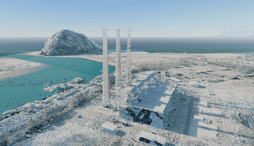
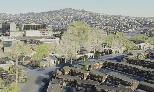
Integrated mesh scene layers
An integrated mesh scene layer is generally created for citywide 3D mapping. It is often captured by drones and structures from motion mapping.
Integrated mesh scene layers support custom materials that apply to the entire layer and mesh modifications that remove areas specified by polygon areas.

Building scene layers
A building scene layer is a 3D representation of a building model, which may be derived from 3D construction content, such as 3D BIM (Building Information Modeling) data. The building scene layer organizes construction data and groups content into standard engineering disciplines. Content in a building scene layer may represent a partial building, an individual building, or multiple buildings on a campus.
A building scene layer could contain both 3D object scene layers and point scene layers as sublayers. However, as point scene layers are not currently supported, they will not be rendered as sublayers. Only 3D object scene layers will be rendered.
With building scene layers, you can control the visibility of sublayers with building filters. If you want to remove areas specified by polygon areas, apply a spatial filter.

Point cloud scene layers
A point cloud layer displays large collections of 3D points, typically captured through lidar, mobile mapping, or drone photogrammetry. Each point stores attributes—such as elevation, intensity, classification, or RGB values—that the dataset uses to represent terrain, vegetation, buildings, or other real-world features.
Point cloud layers support several visualization options, including point size, color by attribute, and density. Depending on the data, you may also apply attribute-based renderers that highlight properties such as elevation, intensity, or classification codes.
Point scene layers
Point scene layers are optimized for rendering large volumes of point data efficiently in real-time 3D environments.
These layers are ideal for visualizing features such as trees, street furniture, or other objects that can be located with a point geometry and represented by a range of marker and model symbols.
Scene services
A scene service
You can use the following kinds of URLs for the source to add services to your ArcGIS Map:
- Item page URL (recommended). This URL points to the specific item page of a service. It provides details about the item, such as metadata, sharing settings, and access options. You can find it by navigating to the item page on ArcGIS Online or in your portal and copying the URL from the browser address bar.
- Example:
httpsfor items accessible via the ArcGIS Online public URL or://www.arcgis.com/home/item.html?id=9f86716d941c4410b0b406d911754b2c httpsfor items within your organization.://yourorg.maps.arcgis.com/home/item.html?id=9f86716d941c4410b0b406d911754b2c
- Example:
- Services URL. This URL directly points to the REST endpoint of a web service. You can find the service URL by accessing the service item in your portal and copying the URL from the item's details page (usually at the lower right).
- Example:
https, which is://tiles.arcgis.com/tiles/ P3e PLM Ys2 RV Chk Jx/arcgis/rest/services/ Esri _Hydro _Reference _Overlay/ Map Server https://yourserver.domain.com/arcgis/rest/services/ Your Folder/ Your Map Service/ Map Server
- Example:
Local scene layer packages
Scene layers can also access data from scene layer packages (.slpk files) stored locally.
The plugin currently supports the following types of scene layers from .slpk files: integrated mesh scene layer package, 3D object scene layer package, building scene layer package, and point cloud scene layer package. Scene layer package files are created using different geoprocessing tools depending on the original data files and the desired output. For more information see the Share a scene layer package topic.